► Are you looking for a list of all entries in a place called Nevada? Or in a locality called Nevada? Or in a state or province called Nevada?
By Cosmos Mariner, June 19, 2016
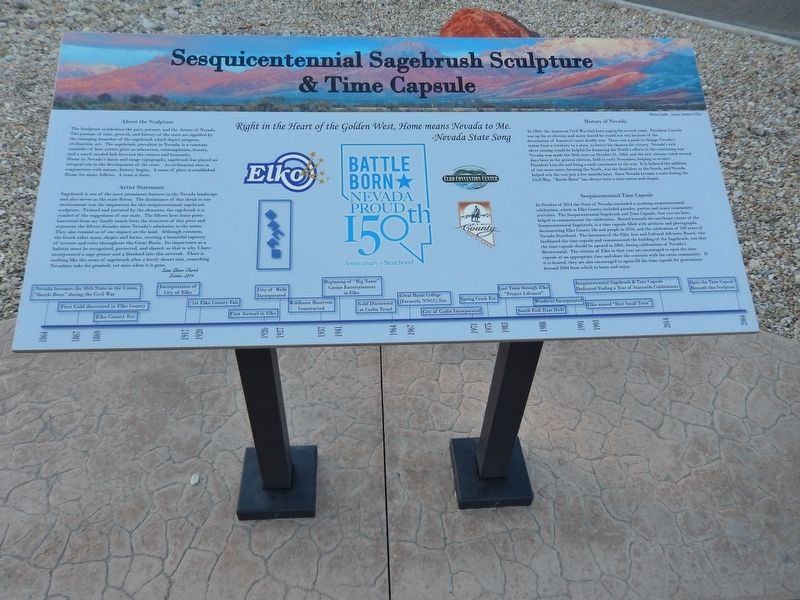
Sesquicentennial Sagebrush Sculpture & Time Capsule Marker
RANKED BY RELEVANCE
| On College Avenue at Idaho Street, on the right when traveling east on College Avenue. |
| On Idaho Street, on the right when traveling west. |
| On Riverside Drive, on the right when traveling west. |
| On Tomera Road near Nevada Route 278, on the right when traveling west. |
| On Railroad Street at 7th Street, on the right when traveling north on Railroad Street. |
| On Court Street, on the right when traveling west. |
| On North Main Street at Bateman Street, on the right when traveling north on North Main Street. |
| On South Street at Virginia Hill on South Street. |
| On Main Street (California Route 152), on the right when traveling west. |
| On Lamoille Canyon Road (Forest Road 660) near Lamoille Highway (Nevada Route 227), on the right when traveling south. |
| On Idaho Street 0.1 miles north of 14th Street, on the left when traveling north. |
| Near S Las Vegas Boulevard. Reported missing. |
| On Idaho Street, on the right when traveling west. |
| Near U.S. 95 at Interstate 80, on the right when traveling south. |
| On Genoa Lane at Main Street, on the right when traveling west on Genoa Lane. |
| Near Interstate 80 at milepost 292, on the right when traveling west. |
| On Railroad Street at 7th Street, on the right when traveling north on Railroad Street. |
| On Idaho Street 0.2 miles north of 14th Street, on the left when traveling north. |
| Near Interstate 80 at milepost 258, on the right when traveling east. |
| Near Interstate 80 at milepost 187, on the right when traveling west. |
| Near U.S. 395 0.1 miles south of Pangborne Lane, on the right when traveling south. |
| Near Western Pacific Way 0.2 miles west of Main Street. |
| On Museum Avenue near Maple Avenue, on the left when traveling west. |
| On Earthquake Fault Road 0.3 miles south of U.S. 50, on the right when traveling south. |
| On W. Hamilton Street at B Street, on the left when traveling west on W. Hamilton Street. |
| On Commercial Street at 7th Street, on the right when traveling south on Commercial Street. |
| On Wendover Boulevard (Business Route 80) 1 mile west of Alternate U.S. 93, on the right when traveling west. |
| On Nevada Route 278 at Palisade Ranch Road, on the left when traveling south on Nevada Route 278. |
| Near Un-named Dirt Road 17 miles east of Interstate 80, on the right when traveling east. |
| On Carolina Beach Avenue North at Scotch Bonnet Lane, on the right when traveling south on Carolina Beach Avenue North. |
| On North Cooley Street, on the left when traveling north. |
| On Monterey Road (California Route 82). |
| Near Interstate 80 11.8 miles west of Nevada Route 306, on the right when traveling west. |
| Near Truckee River Lane near West Street. |
| On Railroad Street at 7th Street, on the right when traveling north on Railroad Street. |
Thin black lines indicate changes in relevance. Between each pair of lines entries are ordered geographically but all have the same relevance.* Inflectional forms of words are their plurals, singulars, and possessives as well as gramatical tenses and similar variations.
Oct. 24, 2026
