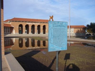
On South Main Street, on the right when traveling south.
Designed by Phoenix architects Royal W. Lescher and John R. Kibbey and completed in 1916, this neo-classical revival style structure has overtones of the Spanish revival style. The school board chose a one story as the children would have already . . . — — Map (db m26623) HM
On North Main Street north of 12th Street, on the left when traveling north.
Built in 1948, this Contemporary Pueblo Revival building initially housed all town government administration and the Town Council chambers. The Town had a mayor and council-commissioner form of government. With limited staff, each Councilmember was . . . — — Map (db m195851) HM
On North Willow Street near 10th Street, on the right when traveling north.
The Florence Woman's Club was organized in 1897. In 1929, architects Lescher & Mahoney designed this Spanish Colonial Revival Style clubhouse. The original light fixtures are suspended from the ceiling, and an ornate Spanish-style fireplace is . . . — — Map (db m26746) HM
On West Ruggles Avenue, on the left when traveling west.
This was originally a flat-roofed Sonoran adobe built in 1875 for George A. Brown, Adamsville saloon keeper. The house served briefly as the Wells Fargo office during a rash of stagecoach robberies. "By God" Brown known for his oft-repeated phrase, . . . — — Map (db m26710) HM
On South Central Avenue, on the right when traveling north.
This Colonial Revival adobe was the home of George Brockway and his wife Esther. Brockway was the town medical doctor, Pinal County Hospital Superintendent and Territorial Prison physician. He owned a drugstore, and in 1908 became the first mayor of . . . — — Map (db m26712) HM
On Florence-Coolidge Highway (State Highway 287) at East Adamsville Road, on the right when traveling west on Florence-Coolidge Highway.
In the 1870's, a flour mill and a few stores formed the hub of life in Adamsville, where shootings and knifings were commonplace, and life was one of the cheapest commodities. Most of the adobe houses have been washed away by the flooding Gila River. — — Map (db m26805) HM
Near East Adamsville Road 1.2 miles west of South Main Street.
March 12 1825 - Jan 11 1891
Judge- District court of New Mexico
Delegate to Confederate Congress
Arizona Mounted Volunteers CSA
Territorial legislature
US Congress
Pioneer- Soldier- Statesman — — Map (db m32394) HM
On West Ruggles Street, on the left when traveling west.
The smaller adobe outbuilding was constructed by Granville Wheat and appears on an 1869 army map of Florence. The flat earthen roof was replaced with a rare mono-pitched waterproof metal roof. The original door and wood frame remain. Wheat was a . . . — — Map (db m68341) HM
On South Main Street near Brady Street, on the right when traveling south.
This example of Early Transitional architecture combined Sonoran and Victorian elements. Built of adobe in 1880, the house was later veneered with red brick to give it a Victorian appearance. Physician William Harvey was known as an "Angel of Mercy" . . . — — Map (db m184138) HM
On East Butte Avenue east of North Park Street, on the right when traveling east.
Dr. George Huffman built this large, two-story Bungalow-style adobe house to accommodate his family and his medical practice. Surgical rooms were located on the first floor with rooms for patients upstairs. Square pillars support full-width porches. . . . — — Map (db m32439) HM
On North Silver Street, on the left when traveling south.
Ignacio Manjarres was a rancher in Florence as early as 1898 when a brand was registered in his name with the county. He was a charter member of the Pinal County Cattle Growers Association. At various times he raised sheep and pigs, fruit trees and . . . — — Map (db m68360) HM
On North Pinal Street, on the left when traveling north.
Built in 1888 for Swiss-born tinsmith Jacob Suter. Constructed of adobe brick with 20-inch-thick outer walls. The house displays a traditional Sonoran floor plan and originally included a zaguan, or breezeway. The wood mansard roof, windows, and . . . — — Map (db m26748) HM
On North Baily Street, on the right when traveling north.
Jesus Martinez, a farmer from New Mexico, began construction on this adobe house in 1872. Completed in 1880, the U-shaped building had a traditional Sonoran flat dirt roof and central patio enclosed on three sides. By 1890 the house was divided . . . — — Map (db m26683) HM
On East 11th Street at North Baily Street, on the left when traveling west on East 11th Street.
In 1880, Juan Luna built this single-story, Sonoran-style adobe house for his wife and put the title in her name. According to Spanish tradition, it was the polite thing to do. The building's two L-shaped wings are one-room deep, and the original . . . — — Map (db m26791) HM
On North Willow Street near 9th Street, on the left when traveling north.
This single-story adobe, built in 1888, retains its basic integrity as an example of the symmetrical, pyramidal-roofed, Late-Transitional style. Keating was a pioneer stage driver. He served as a territorial legislator, Florence town councilman, and . . . — — Map (db m26803) HM
On North Baily Street, on the left when traveling north.
Called the "New Beer Hall," this single-story, mud-roofed, one-room deep, adobe Sonoran-style house was said to be "the coolest place in town" by owner John Nicholas. In 1890, the Arizona Weekly Enterprise, Florence's second newspaper, leased . . . — — Map (db m26794) HM
On East 11th Street near North Baily Street, on the right when traveling west.
Designed by prominent Arizona Architect James M. Creighton, this is the oldest standing fired-brick building in Florence. Soon after completion, French-born rancher-farmer John Nicholas moved his saloon to this building in 1889. Tradition has it . . . — — Map (db m26792) HM
On North Granite Street, on the left when traveling north.
Built in 1878 for John P. Clum, Indian agent, editor of Florence's first newspaper, the "Arizona Citizen" and founder of the "Tombstone Epitaph."
Typical of transitional architecture, the home is a Sonoran adobe with an Anglo-influenced roof. . . . — — Map (db m26744) HM
On North Willow Street, on the right when traveling north.
One of a series of Craftsman bungalows on Willow Street, this was the home of the John Zellweger family. Zellweger was a founder of the First National Bank of Florence. His father and George Push owned the large Steam Pump Ranch north of Tucson. . . . — — Map (db m68339) HM
On North Main Street near 8th Street, on the right when traveling north.
Juan Avenenti, an Italian immigrant who came to Arizona about 1870, purchased this property in 1886 from Frank M. Griffen. Previously, it had belonged to Florence pioneers Levi Ruggles and Charles Douglas. Avenenti, a grocer, butcher and rancher, . . . — — Map (db m26736) HM
On East 8th Street, on the right when traveling east.
This first Catholic Church in central Arizona, built in 1870 by Father Andre Echallier, was called "La Capilla del Gila". In 1883 a larger edifice commemorating the Assumption of the Blessed Virgin Mary, was constructed to the west: a convent was . . . — — Map (db m26689) HM
On West Ruggles Avenue, on the right when traveling west.
Civil War veteran Levi Ruggles came to Arizona Territory in 1866 as a U.S. Indian Agent. Recognizing the agricultural potential of this valley, he found an easily fordable crossing on the Gila River and surveyed a townsite here. He called the . . . — — Map (db m26709) HM
On North Baily Street north of East Butte Avenue, on the right.
Manuel Robles made the adobes and built this house in 1881. The single-story residence is an excellent example of a modified Sonoran-style rowhouse. Originally it was an L-shaped structure with a flat earth-filled roof, then about 1913 a flat metal . . . — — Map (db m30403) HM
On North Main Street, on the right when traveling south.
Built in 1925, this is an example of early 20th Century Commercial style. One of three structures in Florence designed by George Mauk of Phoenix. He was an architect movie house mogul, and U.S. marshal. This building was used as Arizona Edison and . . . — — Map (db m26733) HM
On East Ruggles Street, on the right when traveling west.
Frenchman Jean Baptiste Michea and his wife, Carmen Robles of Sonora built a 3-unit rowhouse/store on this site by 1878.
Typically Sonoran in style, it was built up to the property line, and had plastered adobe walls with an earthen roof over . . . — — Map (db m67495) HM
On North Baily Street, on the left when traveling north.
French-born John Nicholas built this single-story flat-roofed, Sonoran-style, adobe house along the side-street property line. Its raised foundation offered some protection from flooding. Originally rectangular, it was L-shaped in 1890 and square by . . . — — Map (db m26793) HM
On North Pinal Parkway (State Highway 79) 0.1 miles south of East Hunt Highway, on the left when traveling north.
Charles Debrille Poston, 1825-1902, often referred to as the "Father of Arizona", promoted territorial status for Arizona during President Lincoln's administration. Poston, motivated by silver mining interests lobbied for federal legislation to . . . — — Map (db m26661) HM
On North Granite Street at 6th Street, on the right when traveling south on North Granite Street.
In 1876, Roderick Ross, one of Florence's first blacksmiths, constructed this Sonoran-style adobe house. The original flat earthen roof made of round log beams, saguaro ribs, and mud is well-preserved by a gable roof added between 1899 and 1910. . . . — — Map (db m131734) HM
On North Pinal Street near 10th Street, on the right when traveling north.
The oldest portion of this adobe was built for Sam Kee in 1882. Typical of Sonoran row houses, this home was built on the property line and was transformed to late-transitional style in 1977 by the addition of the wood-shingled, hipped roof . . . — — Map (db m26747) HM
On North Main Street at Ruggles Avenue, on the left when traveling north on North Main Street.
Built in 1876 for William Long, a partner in the Silver King Mine. Originally an unplastered, L-shaped adobe with gabled roof, the Silver King was renamed the Florence Hotel in 1890. Fire destroyed a portion of the hotel which was replaced by the . . . — — Map (db m26665) HM
On North Baily Street, on the right when traveling north.
This one-story, detached dwelling began as an American Victorian-style building, with walls of locally made brick and a metal-covered, timber-framed hip roof. Brick arches topped door and window openings. Bungalow-style additions included an open, . . . — — Map (db m26802) HM
On East Buttle Avenue near Orlando Street, on the right when traveling east.
This second-oldest Presbyterian Church in continuous usage in Arizona was founded in 1888. The present building was designed by architects Wallingford and Bell of Phoenix in the Spanish Colonial Revival style, with mission-type tile on the roof. . . . — — Map (db m26627) HM
On South Matilda, on the right when traveling north.
The Fulbrights moved into the home on February 14, 1934 continuing to complete the house as cash became available. The adobe patio wall was completed in 1934, the outside and inside walls were plastered in 1937 and the tile roof was installed in . . . — — Map (db m71776) HM
On South Main Street, on the right when traveling north.
This is the original Tony, Jr. that was used for the memorial to Tom Mix which was dedicated on December 5, 1947, south of Florence.
The silhouette was designed by Fernando Arriola. This Tony, Jr. was stolen and missing for two years. The . . . — — Map (db m26672) HM
On South Main Street, on the right when traveling south.
A transformed early Sonoran adobe, this house is the only structure in Florence that has a full second story added to an adobe core. Built by W. C. Truman, the sheriff known for capturing lady stagecoach robber Pearl Heart in 1900, it was later . . . — — Map (db m26625) HM
On North Main Street, on the right when traveling north.
In 1901, Aquiles Arriola opened his store here with a great variety of goods lining the store walls. Arriola's son, Gustavo, grew up to be a well-known cartoonist with his own comic strip "Gordo". He wrote in his auto biography "Accidental . . . — — Map (db m71775) HM
On East Ruggles Street at Church Street, on the right when traveling east on East Ruggles Street.
Originally a Sonoran adobe row house built C. 1877 for John D. Walker friend, agent, and physician to the Pima Indians at Sacaton. This building was used as courtroom and county offices during his terms as justice of the peace, county surveyor and . . . — — Map (db m68386) HM
On North Main Street near 8th Street, on the right when traveling south.
This single-story commercial building includes a partial basement, wide-open interior spaces, and a tall, carefully detailed, Main Street store front of exposed, buff-colored, pressed brick. The other walls are composed of common red brick. A metal . . . — — Map (db m26735) HM
On North Main Street near 10th Street, on the right when traveling south.
Built for Silver King mining engineer William Clark in 1884, this house is a prime example of cultural fusion in architecture.
The Sonoran mud-plastered adobe walls were combined with an elegant Victorian louvered bay window, prefabricated . . . — — Map (db m26737) HM
The Gila River north of this site marked the international border of the United States and Mexico from 1848 to 1854. James Gadsden negotiated to purchase 38,000 sq. miles of "wild country" for $15 million in gold. Amended to $10 million for 29,640 . . . — — Map (db m33689) HM
The Gila River north of this site marked the international border of the United States and Mexico from 1848 to 1854. James Gadsden negotiated to purchase 38,000 sq. miles of "wild country" for $15 million in gold. Amended to $10 million for 29,640 . . . — — Map (db m33692) HM
Here the first Government Indian School was established for Pimas and Maricopas in 1871, with Rev. Charles H. Cook as teacher. It was the location of Pima villages, friendly resting place for travelers during the Mexican War and the Gold Rush. It . . . — — Map (db m33688) HM
Here the first Government Indian School was established for Pimas and Maricopas in 1871, with Rev. Charles H. Cook as teacher. It was the location of Pima villages, friendly resting place for travelers during the Mexican War and the Gold Rush. It . . . — — Map (db m33691) HM
Near Casa Blanca Road 0.6 miles east of Interstate 10.
Rivers, Arizona
Gila River Indian Community land was selected by the United States Government as one of ten camp sites and construction was started without the permission of the community. The permit for the United States Government to use the . . . — — Map (db m34537) HM
On North Broad Street 0.1 miles south of Hackney Avenue, on the right when traveling south.
From a Sycamore near this spot, L.V. Grime and C.B. Hawley were lynched on Aug. 24, 1882 for the hold up – murder of Andrew Hall, Wells Fargo Packer, and Dr. S.T. Vail. The culprits had a fair hearing before JP Allen on Wednesday eve, and at 2 . . . — — Map (db m34116) HM
On Alden Road north of Upton Road, on the right when traveling east.
At the outbreak of the Mexican War in 1846, President Polk directed Colonel Kearny to organize the so-called "Army of the West" and to lead it to Santa Fe and thence on to secure California. On August 18, 1846, Kearny claimed the area of Santa Fe . . . — — Map (db m232146) HM
On Alden Road north of Upton Road, on the right when traveling east.
This locomotive is a gift to the citizens of Kearny, Arizona, by the Kennecott Copper Corporation. This is a Porter Air Locomotive, used by Kennecott Copper Corporation in the original underground Ray Copper Mine. It was used to transport men, ore, . . . — — Map (db m232147) HM
Immigrant Mexican miners working for the Ray Consolidated Copper Company named the town of Sonora, built near here in 1911. It boomed as a thriving, dynamic community, rich in Mexican culture, language and traditions. In the mid-1950's, the company . . . — — Map (db m250606) HM
On Mount Lemmon Road 1 mile south of Webb Road, on the right when traveling south.
Isaac Lorraine, discoverer of the American Flag gold and silver mine, built this adobe house about 1877. It served as his residence and headquarters for nearby mining and ranching operations. On December 20, 1880, it became the first post office in . . . — — Map (db m29898) HM
Near South Highjinks Road 0.7 miles north of Campo Bonito Road.
On this site on April 14, 1912, Colonel William F. "Buffalo Bill" Cody – Pony Express rider, plainsman, Indian Wars scout, and Wild West showman – staked the High Jinks gold mine, after investing in Oracle mining for ten years. He sometimes stayed . . . — — Map (db m70305) HM
Dedicated to those Confederate frontiersmen who occupied Arizona Territory, C.S.A., created by President Jefferson Davis, February 14, 1862. Just two months later, ten of Capt. Sherod Hunter's Confederate Cavalrymen successfully defended Picacho . . . — — Map (db m73899) HM
Juan Bautista de Anza
National Historic Trail
While the American Revolution brewed on the Atlantic Coast, Spain expanded its New World empire to protect California against the British and Russians. In 1774, Juan Bautista de Anza, commander . . . — — Map (db m82941) HM
Lieut. James Barrett – Co. A.
Private George Johnson – Co. A.
Private William S. Leonard - Co. D
1st California Cavalry Volunteers
killed April 15, 1862 at Picacho Pass.
In only battle of the Civil War
fought in Arizona . . . — — Map (db m73897) HM WM
The Mormon Battalion of the U.S. Army camped here enroute to California December 17, 1846. During the war with Mexico, on the longest infantry march of record, they were first to unfurl the flag of the United States in Tucson.
This marker . . . — — Map (db m92383) HM
On East Cam Correo south of Interstate 10, on the right when traveling east.
Established June 14, 1887. A small conical red peak gave Red Rock its name. Red Rock was a major cattle shipping point via the S.P. Railroad. This post office celebrated its
Centennial in June 1987. — — Map (db m31190) HM
On Sacaton Road (Arizona Route 87) at Sacaton-Casa Blanca Road, on the right when traveling east on Sacaton Road.
Dedicated to
Ira H. Hayes USMC
February 23rd 1992
by the Memorial Committee
Lance Lewis Director,
Shirley Lewis Coordinator
JR Currea Artist
In Country Vietnam Veterans
Post 2 Tempe Arizona
Ira H. Hayes American . . . — — Map (db m32845) WM
On Casa Blanca Road at Sacaton Road, ( Route 87), on the right when traveling east on Casa Blanca Road.
Dedicated to the Memory of
Matthew B. Juan
Co K 28th Infantry
First Arizonian Killed in the World War
Battle of Cantingy
May 28th 1918 — — Map (db m42026) HM
On Sacaton Road (Arizona Route 87) at Casa Blanca Road, on the right when traveling east on Sacaton Road.
Honoring Native American
Women Veterans
Dedicated February 22, 2003
American Legion Post 84
Sacaton, AZ
Sculptor: Oscar Urrea
Artist: Jim Covarrubias — — Map (db m32844) WM
On Sacaton Road (Arizona Route 87) at Sacaton-Casa Blanca Road on Sacaton Road.
Military Order Purple Heart of the U.S.A.
1782 - 1932
Dedicated to
KIA-MIA-WIA
In memory of tribal members
by
Military Order of Purple Heart Sun Lakes, Arizona Chapter 1958
in the year 2000
[ Lower Plaque: ]
This . . . — — Map (db m40341) HM
The Pinal Cemetery served the nearby mill town of Picketpost/Pinal (1876 to 1892), which processed the silver ore taken from the Silver King Mine. Resting here in a cross-section of people from the surrounding area: the first settlers, miners, mill . . . — — Map (db m73003) HM
On U.S. 60 at milepost 223, on the right when traveling east.
A landmark and lookout point during Indian Wars; site of outpost of Camp Pinal which was located at head of Stoneman Grade to the east. Soldiers protected Pinal City and the Silver King Mine from Apache raiders. It was the home of Col. William Boyce . . . — — Map (db m34122) HM
Born in Rutledge, Tennessee, he became a self-taught construction engineer and builder of railroads. In 1909, he settled in the mining town of Superior, site of the Magma Copper Company. He opened his first drug store in Superior in 1913, later . . . — — Map (db m34104) HM
On U.S. 60 at milepost 226.3, on the left when traveling east.
This historical trail began in 1997 when Broken Hill Proprietary Company Limited ( BHP ) donated local mining artifacts from the 120 year old magma mine to the Superior Historical Society, Inc. due to their age and size, it was determined that these . . . — — Map (db m67494) HM
Near U.S. 60 at milepost 223 at Boyce Thompson Road, on the right when traveling east.
Colonel William Boyce Thompson was a mining promoter, financial magnate, and Red Cross officer. He fell in love with the Picketpost Mountain area when he first visited his Magma Copper Mine near Superior and chose this spot for his winter home. . . . — — Map (db m117109) HM
167 entries matched your criteria. Entries 101 through 167 are listed above. ⊲ Previous 100