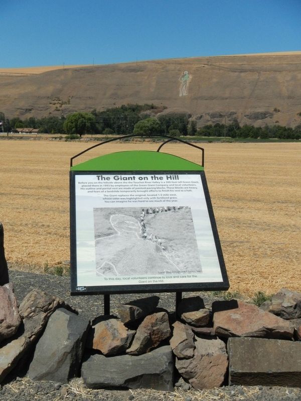
Before you on the hillside above the Touchet River Valley is a 300-foot tall Green Giant, placed there in 1993 by employees of the Green Giant Company and local volunteers. His outline and partial vest are made of painted paving blocks. These . . . — — Map (db m158960) HM
This vanishing grist wheel and it's mate in the 'run', built in 1867, were shipped around the horn from the Gristwheel Foundry Yorkshire Great Britain. — — Map (db m308089) HM
"well timbered pine land"
While camped along the Touchet River a few miles west of here, Lewis and Clark commented on the familiarity of the countryside: "I see very little difference between the apparent face of the country . . . — — Map (db m312112) HM
This land will always be home to the Cayuse, Umatilla and Walla Walla people. The land is used by and shared with relatives and neighbors such as the Palouse, Wanapum, Yakama, Wishxam, Wyam, Tenino and Nez Perce.
In 1805 and 1806, Lewis . . . — — Map (db m312124) HM
William Clark Meriwether Lewis
" my friend ... If therefore there is anything...in this enterprise which would induce you to participate with me in it's fatigues, it's dangers and it's honors, believe me there is no man on . . . — — Map (db m312056) HM
"the young and succulent stem of a large course plant" President Thomas Jefferson instructed Meriwether Lewis to observe the "soil and face of the country; its growth and vegetable productions, especially those not known to the United . . . — — Map (db m312121) HM
Welcome to the homelands of the Nimiipuu (meaning "the people") or Nez Perce tribe and other tribes of the Columbia Plateau. As you travel the Lewis and Clark Trail and across tribal homelands, please be good stewards and respectful . . . — — Map (db m312070) HM
M - R
Military
Wagon Road
Located by
Capt. John Mullan
1858-1862
Pyramid erected by
Mullan Road Ass'n
Tablet Furnished by
Washington State
Historical Society
1926 — — Map (db m113458) HM
"Swifter than any horse could run"
In fall 1805, the Lewis and Clark Expedition raced against time, hoping to reach the Pacific Ocean before winter set in. Traveling faster than at any other time during the journey, the party often . . . — — Map (db m312055) HM
"great quantities of the qualmish"
After breaking camp on May 4, 1806, a cold and disagreeable morning, the Lewis and Clark Expedition crossed 'Alpáha (Alpowa) Summit, just north of here. The explorers noticed the rich soil of . . . — — Map (db m159274) HM
"the road leaves the creek"
You can see where two timeworn trails once intersected here. The trail descending the hillside (Photo B) crossed the Patáha Creek valley trail, and then continued up the hill to the northeast (across . . . — — Map (db m159254) HM
[Front]
Erected by
Garfield County
Roster of Deceased Comrades
Collins, Michael • Garrett, David - Co. E, 134 Ill. In. • Hand, Cyrenus - Co. C, 47 Ill. In. • Ryan, Thomas - Co. I.N.Y.H.A. • Spedden, Col. R.R. - 40 Mo. • Conwell, . . . — — Map (db m197093) WM
Early in May, 1806, Captains Meriwether Lewis and William Clark, with a 30-man party and 23 pack horses passed eastward through this roadless area after wintering near the ocean at the western terminus - Fort Clatsop. They were short of food, horses . . . — — Map (db m159255) HM
On May 3, 1806, the Lewis and Clark Expedition camped at a grove of cottonwoods approximately 100 yards south of here after a "disagreeable journey of 28 miles" up Pataha Creek. Supper that night consisted of scant rations of dried meat and dog. A . . . — — Map (db m312243) HM
Famous for its annual Christmas Lights Celebration, Colton is well situated as a bedroom community between Pullman and Clarkston. Descendants of some of its early German settlers continue to farm wheat, garbanzo beans, peas, barley, and . . . — — Map (db m129097) HM
Shooting the Rapids
The Lewis and Clark Expedition successfully navigated 139 miles of the raging Snake River in six days (October 10-16). 1805). The explorers had to contend with long stretches of boiling-rapids, churning whirlpools . . . — — Map (db m312470) HM
"we can kill no game in these plains"
Finding food for 33 people was a constant challenge for the Lewis and Clark Expedition. During fall 1805 and spring 1806 when the explorers passed through this region, they had a difficult time . . . — — Map (db m312460) HM
The original wooden church was built by the United Presbyterians in 1899 for $4,000. In 1913, the building was moved to the back of the lot with a brick addition built in front. The entire church was then veneered with Tenino sandstone for $50,000. . . . — — Map (db m305948) HM
Built at a cost of $84,000 with federal funds from the Johnson Administration's Highway Beautification Program, this safety rest area has been in use since October 1967. Last year over 282,000 used this facility. — — Map (db m303269) HM
Here on May 17, 1858, 159 American soldiers, commanded by Lt. Col. E.J. Steptoe, engaged in a running fight with a large band of Spokane, Palouse and Coeur D'Alene Indians. Taking cover on a nearby hill, they beat off a series of attacks until night . . . — — Map (db m269025) HM
This butte was first called Pyramid Peak. It was named “Steptoe” for a commander in the Indian wars at a battle in 1858 near the present town of Rosalia. In the 1880s James S. Davis built a resort and observatory on the Butte’s top. A . . . — — Map (db m129095) HM
122 entries matched your criteria. Entries 101 through 122 are listed above. ⊲ Previous 100