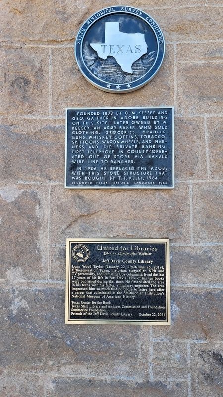
Lonn Wood Taylor (January 22, 1940-June 26, 2019), fifth-generation Texan, historian, storyteller, NPR and TV personality, and Rambling Boy columnist, lived the last 17 years of his life in Fort Davis. Five of his ten books were published during . . . — — Map (db m220362) HM
Ruins of
the ranch home of Manuel Musquiz,
a pioneer who settled here
in 1854
Abandoned due to Indian raids
the deserted buildings served as
a Ranger Station intermittently,
1880 - 1882
while the country was being
cleared of . . . — — Map (db m145336) HM
Original unit in complex forming one of the great observatory centers of the world. Built in the 1930s under terms of legacy from William Johnson McDonald (1844-1926), a Paris (Texas) banker interested in the stars. A well-educated man, McDonald . . . — — Map (db m228569) HM
The location of Fort Davis's town square is the outcome of competition between two pioneer entrepreneurs and two types of American townscapes.
Daniel Murphy was an Irish immigrant who saw service in Mexico during the Mexican War. He lived in . . . — — Map (db m218630) HM
Confederate supply point and frontier outpost on great military road from San Antonio to El Paso 1861-62. After surrendered by U. S. Army, occupied by detachment 2nd Texas Mounted Rifles. Apaches ambushed patrol from fort under Lt. Mays in Big Bend . . . — — Map (db m73299) HM
Used from 1870s to 1914. Settlers buried here include: Mr. and Mrs. Diedrick Dutchover, immigrants from Belgium and Spain; their surname, coined by a recruiter in the Mexican War, is borne by many descendants. Dolores, who on her wedding eve . . . — — Map (db m178374) HM
Andrew Prude purchased three sections of land here in 1897 from J.F. Taylor, and established the A.G. Prude Ranch. Soon he moved his wife Ora to a small log house on their property on Limpia Creek. In 1900 he completed a wooden frame house for . . . — — Map (db m128292) HM
Westward expeditions opened trails from San Antonio to El Paso in the late 1840s. Two routes, called the upper and lower roads, converged at the Pecos River to traverse the Davis Mountains.
Henry Skillman (1814-1864) began a courier service . . . — — Map (db m61196) HM
2nd Lieutenant Robert Safford
Troop C, 10th U.S. Cavalry
In July 1879, the young lieutenant came down with dysentery, an infection of the lower intestines that produces severe diarrhea, pain, and fever. He was scouting for Mescalero . . . — — Map (db m218511) HM
In 1873, Archie Smith, a former Buffalo Soldier in the 24th U.S. Infantry at Fort Davis, built a home on 160 acres near the base of Dolores Mountain using local materials. Native oak beams support the near-rectangular one-story adobe. A large room . . . — — Map (db m234776) HM
Catholic clergy began serving residents of the Fort Davis area about 1872. Father Joseph Hoban was appointed pastor in 1876 and the First St. Joseph Catholic Church building was erected in 1879. Father Hoban was followed by circuit-riding priest who . . . — — Map (db m61208) HM
Where you are standing was once a crossroads of activity for Fort Davis. Guarding the mail, building roads and telegraph lines, scouting for water, and searching for elusive Apaches or Comanches were not the only duties of soldiers. Many critical . . . — — Map (db m218392) HM
F Co. 2nd Bat. 142nd Inf. Reg. 36th Inf. Div. At Salerno, 9, Sept. 1943, alone: 4 machine gun nests, one mortar squad, one 88mm gun, wounded…kept going. At Cassino: knocked out Mark IV tank with a bazooka.
Distinguished Service Cross, Silver . . . — — Map (db m61145) HM
In 1854, the U.S. Army established Fort Davis, which extended from this location westward into the box canyon. Initially, the fort consisted of crude wooden buildings with thatched and canvas roofs. Six stone barracks were later erected for the . . . — — Map (db m96009) HM
Chapel... library. . . schoolroom. . . and Friday night ballroom, this unadorned building was the community center.
Mattie Belle Anderson, the town's first schoolteacher wrote, "A non- commissioned officer conducted a school for the children in . . . — — Map (db m218486) HM
An excellent example of a Queen Anne style house executed in native stone, adobe, and milled wood, this house was built about 1898 as a summer home for the family of Henry M. and Annie Trueheart, residents of Galveston, where Mr. Trueheart was a . . . — — Map (db m61195) HM
Founded 1873 by O. M. Keesey and Geo. Gaither in adobe building on this site. Later owned by W. Keesey, an army baker, who sold clothing, groceries, cradles, guns, whiskey, coffins, tobacco, spittoons, wagonwheels, and harness, and did private . . . — — Map (db m61193) HM
In early days the Indian trail through these mountains followed the gorge below known as Limpia Canyon. To avoid the floods travelers over the San Antonio - El Paso Road, emigrants, U.S. troops and supply trains, and the mail chose this higher pass . . . — — Map (db m239563) HM
Valentine was established in 1881 as a station on
the Southern Pacific Railroad. Although legend
suggests that the town received its name by being
founded on Valentine's Day, it is more likely that
it was named for Southern Pacific . . . — — Map (db m164555) HM
Education for local children of Mexican descent dates from 1889, when the former Methodist church became a schoolhouse. The school, named for longtime principal Jesse Blackwell, served hundreds of Hispanic children up to ninth grade. Students were . . . — — Map (db m60796) HM
Constructed in 1920, Building 98 housed the officers club and bachelor officers quarters for Fort D. A. Russell. During the latter years of World War II, from 1943 to 1945, German prisoners of war from Field Marshal Erwin Rommel’s Afrika . . . — — Map (db m26356) HM
Named for the nearby Paisano Mountain pass, this structure was completed in 1930. Gateway Hotel Company, owners of several area hotels, built it in anticipation of a local oil boom that never materialized. The architectural firm Trost and Trost of . . . — — Map (db m53926) HM
Originally named Camp Marfa, this installation began as a supply post for U.S. Army border patrol stations in 1911. It was a cavalry camp during the years of the Mexican Revolution. Renamed for Civil War general David Allen Russell, it became a . . . — — Map (db m56185) HM
This was the home of rancher, merchant and community leader John Humphris and his wife Mary. Built in 1883 by local builder Saturnino Naborette, the house represents traditional building methods of early pioneer days in west Texas, with a central . . . — — Map (db m60797) HM
In 1940, Marfa received a Works Progress Administration (WPA) grant of more than $15,000 to help build a new gymnasium named to honor athletic director Boren Hunter. The modified rectangular plan building features plastered adobe infill walls, a . . . — — Map (db m60810) HM
A very famous Texas Ranger. Born in Austin, son of Adjutant General of Texas. At 16 became cowboy on western frontier. At 19 joined Rangers; hunted down raiding Indians, rustlers, feuding settlers. After serving 1875-1881, became El Paso city . . . — — Map (db m215123) HM
The Marfa Lights, mysterious and unexplained lights that have been reported in the area for over one hundred years, have been the subject of many theories. The first recorded sighting of the lights was by rancher Robert Ellison in 1883. Variously . . . — — Map (db m26358) HM
The Marfa Mystery Lights are visible on many clear nights between Marfa and Paisano Pass as one looks towards the Chinati Mountains.
The lights may appear in various colors as they move about, split apart, melt together, disappear and reappear. . . . — — Map (db m290096) HM
Above the scenic mountains surrounding the Marfa
Plateau, an abundance of atmospheric energy
attracts gliding enthusiasts from around the world.
Since 1960, sailplane pilots have utilized convective
thermal updrafts, the "Marfa Dry Line" and . . . — — Map (db m245102) HM
Built in 1920 by the Galveston, Harrisburg, and San Antonio Railway Company, the Marfa stockyards provided a central shipping point for livestock raised in Presidio, Jeff Davis, and Brewster counties. As many as 70,000 head of cattle were shipped . . . — — Map (db m60811) HM
The earliest large-scale cattleman to settle in the Big Bend, Milton (Don Meliton) Faver prospered against seemingly impossible odds to become the first cattle baron west of the Pecos. While operating a freighting business on the Chihuahua Trail, he . . . — — Map (db m240786) HM
Milton Faver (ca.1822-1889), a native of the Midwest United States, moved to this area in the 1850s from Presidio del Norte, where he owned a general store and operated a freighting business on the Chihuahua Trail. By the 1880s, Faver controlled . . . — — Map (db m60848) HM
Legend recounts that two Spaniards meeting here greeted each other "Mi Paisano" (My Countryman). First known to history when Juan Dominguez de Mendoza camped here on January 3, 1684. Well known after 1850 as a point on the Chihuahua Trail, an . . . — — Map (db m26360) HM
Porvenir was a community in remote northwest Presidio County on the Rio Grande. In the midst of military conflicts and raids across and along the international border and in the immediate area during the Mexican Revolution, the small farming and . . . — — Map (db m141382) HM
At confluence of Concho and
Rio Grande Rivers.
A settlement for over 10,000 years
Site of
first recorded wagon train
crossing into Texas
December 10, 1582
Headed by Antonio de Espejo — — Map (db m215858) HM
Formed from Bexar County
Created January 3, 1850
Organized March 13, 1875
So named for the early "Fortress
garrisoned by soldiers."
Erected for the protection of the
Big Bend missions.
County seat
Fort Davis, 1875
Marfa, . . . — — Map (db m60843) HM
A landmark of the Big Bend. Large dome is visible for miles. Constructed of native stone and brick made at Marfa. Stucco added later.
Built 1886 in this county's third seat of justice. First county seat was Fort Leaton, on the Rio Grande; . . . — — Map (db m60809) HM
During World War II, the U.S. Army Air Forces (USAAF) established a significant number of training airfields across the state of Texas. The USAAF Western Flying Training Command selected Marfa as the site for an advanced multi-engine flying school . . . — — Map (db m26477) HM
English natives John and Mary (Walker) Humphris came to Texas in the early 1870s and arrived in Marfa in 1883. John, his brother-in-law, James Walker, and partner Charles Murphy founded Humphris and Co., which became the largest mercantile between . . . — — Map (db m139129) HM
Kentucky native William Edward Russell (1839-1890) came to Texas in the 1850s and worked his way to the Big Bend region, where he traded along the Chihuahua Trail and had a store at the Horsehead Crossing of the Pecos River. Russell became a . . . — — Map (db m240835) HM
One of nine Missions established in the Big Bend country by Father Fray Nicolas Lopez, O.F.M., and Don Juan Dominguez de Mendoza in 1683-1684. Maintained by Franciscan missionaries for the civilizing and Christianizing of the Jumano, Julimes and . . . — — Map (db m234634) HM
Born in Kentucky. Came to Texas before 1846. Was a U. S. Army scout in Mexican War. Established the first mail service from San Antonio to El Paso in 1851.
Drove first Butterfield Overland mail coach in 1858 through dangerous Comanche Indian . . . — — Map (db m60854) HM
About 1773, the Spanish garrison at Presidio del Norte, present Ojinaga, Mexico, established El Fortin de San Jose in this vicinity to protect local farmers. The settlement retained the name after the post was abandoned about 1810. After Ben Leaton . . . — — Map (db m60855) HM
First Anglo-American farmer
in Presidio County
In August 1848, Mr. Leaton acquired
the building and it has since
been known as Fort Leaton — — Map (db m234608) HM
Approximate site of
Mission del Apostol Santiago
One of nine missions established
in the Big Bend country
by Father Fray Nicolas Lopez, O.F.M.,
and Don Juan Dominguez de Mendoza
in 1683-1684
Maintained by Franciscan missionaries . . . — — Map (db m234607) HM
Proximate site of Presidio del Norte de la Junta established by Captain Alonzo Rubin de Celis in 1759-1760. Name of post retained in part by the present town and county. In this vicinity the missions of San Antonio de los Puliques, San Francisco . . . — — Map (db m234606) HM
George H. Brooks (1833-1911) served in a California volunteer unit during the Civil War before settling in Presidio County in the 1860s. In 1878 he married Mexican native Ygnacia Reza. This cemetery began with the burial of their son, Albion E. . . . — — Map (db m60851) HM
Here
Milton Faver
established in the fifties the first
Anglo-American owned ranch
in the Big Bend
Three quadrangular adobe fortresses
situated at the Big Springs
Cibolo, Cienaga and La Morita
served as a defense against
hostile . . . — — Map (db m60852) HM
150 entries matched your criteria. Entries 101 through 150 are listed above. ⊲ Previous 100