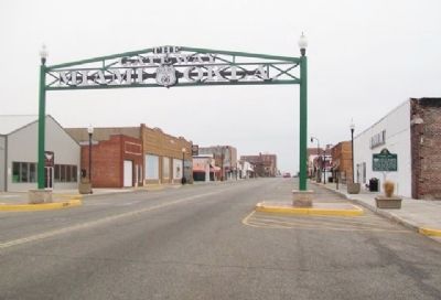
A replica of a sign originally constructed in the 1900's that spanned Central and C Street adjacent to the railroad station. For many years this sign welcomed visitors to downtown Miami. The original sign was removed during the 1930's. Today's . . . — — Map (db m119947) HM
In 1833, this area ceded Quapaw Tribe by U.S. Lands near granted Indians of 20 Tribes including Seneca, Shawnee, Peoria, Miami, Ottawa, Wyandot. Wealth came to the Quapaw and other Indians here, from discovery of lead and zinc mines beginning in . . . — — Map (db m77948) HM
The Modoc Church and Cemetery, the last remaining site commemorating the 153 Modoc prisoners of war exiled to the Quapaw Agency, Indian Territory in 1873. — — Map (db m80586) HM
A battle at Ingalls, Sept. 1, 1893, between a Dalton-Doolin gang and U.S. marshals was a climax in bringing law and order to Oklahoma and Indian territories. Three marshals and two residents were killed; several persons were wounded; one outlaw was . . . — — Map (db m52624) HM
J.E. Wright, D.D.S., opened first permanent dental office in the Indian Territory, Savanna, 1885. He practiced as itinerant dentist at Tishomingo Academy, Stonewall, Johnsonville, and White Bead Hill before settling in Savanna. Moved to South . . . — — Map (db m26088) HM
Occupied 1834 by Chief Black Dog's Osage band on buffalo hunt. Gen. Henry Leavenworth and the First Dragoons, including officers Henry Dodge, S.W. Kearney, R.B. Mason, Jefferson Davis, Nathan Boone, and noted artist, George Catlin, camped here June . . . — — Map (db m64130) HM
Dr. Brewster Higley (b. 1822) of Indiana wrote this song when he lived in Kansas. The words were printed in a local paper (1873) and became a favorite song along the cattle trails. First published in 1910, the author never saw a copy nor received . . . — — Map (db m170625) HM
Louise Funk Fluke (1900-1986) designer of the State Flag of Oklahoma, was born in Arkansas and raised in Shawnee. She entered the winning flag design in a statewide contest in 1925 through the Wunagisa Chapter Daughters of the American Revolution. . . . — — Map (db m181808) HM
This is the site of "Nanih Waiya", first Choctaw Capitol and Council Ground where first constitution written in Oklahoma was adopted by Choctaw Nation, 1834. Joseph Kincaid, Thomas LeFlore, and Nitakechi Chiefs. Tuskahoma Council House last Choctaw . . . — — Map (db m221148) HM
This building was erected in 1884 during term of Chief Jackson McCurtain who made his farewell address there. It housed the offices of Chief, Secretary, Attorney, Treasurer, Auditor and two house Legislature. Now serves as a museum.
. . . — — Map (db m224776) HM
Nov. 27, 1868, Col. George A. Custer, commanding 7th Cavalry, attacked the Cheyenne village of Chief Black Kettle. 153 Cheyenne casualties, and 34 U.S. troops killed or wounded. Among the killed was Capt. L.M. Hamilton, grandson of Alexander . . . — — Map (db m11573) HM
California Road, crossed here. First traveled by gold seekers in Rush for California spring 1849, under military escort commanded by Captain R.B. Marcy, west from Fort Smith, Arkansas. Antelope Hills, 8 miles northwest, once landmark for . . . — — Map (db m113944) HM
Site of battle in "Strawberry Moon" 1817, when Chief Clermont's Osage village was wiped out by Cherokees. This Osage band from Missouri had settled near the mound at insistence of fur traders of St. Louis. Osages became the wealthiest Indians in . . . — — Map (db m40995) HM
Andrew Hartley Payne, a 1927 graduate of Foyil, won the 1928 transcontinental footrace, LA-NYC, a 3423.5 mi. world record in 573 hr 4 min & 34 sec. Andy "Greatest Long Distance Runner in History of Competitive Running" won in the 880 & mile . . . — — Map (db m67809) HM
Injection of water into an oil reservoir to increase recovery was first attempted in Oklahoma on an oil lease 5.8 miles east of this location.
From that effort, a recovery method previously used in eastern fields was adapted to conditions . . . — — Map (db m43783) HM
The largest individual gas reserve in the United States covers much of the Oklahoma panhandle extending northward from Texas through this area and into Kansas this sprawling Hugoton Panhandle field provides gas to comfort mankind fire the boilers of . . . — — Map (db m78818) HM
From this famous well, cattlemen watered their herds of thousands of stock while waiting shipment over the Rock Island Railroad, after long trail drives to the end of the track near old Tyrone. The well was located by J. U. Shade and H. B. Fore in . . . — — Map (db m55271) HM
For years, beginning in 1909, pure sparkling water from a spring here was piped to the water tower behind City Hall. The city grew Christmas trees here during the Depression and sold them in town. As new water sources were secured for the . . . — — Map (db m225259) HM
Ida Sieling, widow of Henry Sieling and daughter of Herman Scheer, landscaped a run-down, city-owned plot of land across the street from her home into a beautiful botanical park. The Self Culture Club donated additional lots in 1938. Sieling Park . . . — — Map (db m42027) HM
The gas processing industry west of the Mississippi River had its beginning near here in 1909 at the D.W. Franchot & Company Plant three miles west of this marker. Liquid hydrocarbons were extracted from gas produced with oil in the surrounding . . . — — Map (db m180697) HM
First called Posey, town dated to 1880s and then was renamed for noted landmark. Citizens moved to Mounds in 1903 when R.R. bypassed town. 1905 discovery of oil nearby on Glenn farm led to boom that lasted into 1920s. Thos. Gilcrease's allotment . . . — — Map (db m180650) HM
This first battle of the Civil War in Indian Territory began 6 miles south, Nov. 19, 1861, when Col. D.H. Cooper's Confederate vanguard was repulsed by Little Captain's warriors from Opothleyahola's Indian allies moving to north of the Ark. River to . . . — — Map (db m52261) HM
This battle site is 9 miles NE., SE at the Caving Banks Bend on Bird Creek. Here Dec. 9, 1861 Opothleyahola's Union Indians forced the retreat of Col. D.H. Cooper's Confederate troops. Marker sponsored by the Tulsa Historical Society. — — Map (db m39564) HM
Prince-Mackey Home
Mabel B. Little Heritage House
322 N. Greenwood Ave.
One of the stately homes of the day, the Prince-Mackey House was built shortly after the Tulsa race war. Their white frame home was destroyed during the battle. The . . . — — Map (db m171409) HM
Constructed on this site in 1913, Booker T. Washington High School served as the separate school for Black students in Tulsa.
The first building was a four-room wooden frame structure. A sixteen-room brick facility with a basement replaced . . . — — Map (db m111510) HM
First oil well in Tulsa County, completed on June 25, 1901 .4 mi west by Drs. J.C.W. Bland and Fred S. Clinton. This well brought first nation wide publicity and oil boom to Indian Ter. Rapid industrial development made Tulsa "Oil Capital of the . . . — — Map (db m34129) HM
The International Petroleum Exposition was founded at Tulsa, Oklahoma, in 1923 providing a display to the world of the latest in equipment, operational ideas and practices used in the petroleum and related industries.
When the first exposition . . . — — Map (db m111504) HM
Creek Indian school founded by Rev. R. M. Loughridge, Presbyterian Bd Foreign Miss. 1843. Coweta, ancient Creek town in Alabama, re-established in this vicinity by Creeks who arrived Ft. Gibson on steamboat, "Facility," 1828. This was home town . . . — — Map (db m68058) HM
Choctaw Indians made hunting expedition from Mississippi to this region, Jan. 1807, led by famous Chief Pushmataha. Camped east on Verdigris River was Joseph Bogy, French trader among Osages, whose armed men engaged Pushmataha's band in battle . . . — — Map (db m73126) HM
This Creek Indian school was founded by Rev. R.M. Loughridge, Presbyterian Bd. [Board] Foreign Miss. [Missions], 1848. Rev. W.S. Robertson was employed as the supt. Rebuilt by Creeks when destroyed by fire in 1880. Operated until 1907 for . . . — — Map (db m73128) HM
Was trading post in 1829-33, named and conducted by ex-Gov. Sam Houston of Tenn., who was called Colonah (The Raven) by his Cherokee friends. As a celebrity in the Indian Ter., Houston was visited by the American author, Washington Irving who . . . — — Map (db m73125) HM
Became Indian Territory's first incorporated town Jan. 4, 1896 under Mansfield's Digest of the Laws of Arkansas. The citizens (about 2,000) sought to form a city government to provide improvements and the upbuilding of society. Wagoner began . . . — — Map (db m68059) HM
Early inhabitants of the area were plains Indians who followed and hunted the roaming herds of buffalo that grazed the rich grasslands of this area. evidence of several Indian encampments have been located on Trail Elk, Turkey and Oak Creeks as well . . . — — Map (db m119435) HM
David Lee Walters, 24th Governor of Oklahoma and first Governor from Western Oklahoma, was born in Canute on Nov. 20. 1951. Raised on a nearby farm, he attended schools in Canute and graduated from Canute High School as Valedictorian in 1969. He . . . — — Map (db m120164) HM
St. Francis of Assisi Church, two miles south and two miles east of present day Canute, was an important outpost of the Roman Catholic Church in western Oklahoma. Founded by Father Steber in 1899, it served as "the mother parish of the west", from . . . — — Map (db m120160) HM
Cloud Creek #1
Washita River Basin
Dedicated July 8, 1948
Rededicated July 3, 1998
Cloud Creek Dam No. 1 located 11 miles southeast of Cordell was the first of 1140 dams in the Washita river basin and the first of over 10.000 . . . — — Map (db m120178) HM
Established Nov. 1868 by Gen. Alfred Sully with 5 companies of 3rd Inf. This was the supply base for Col. Custer's 7th Cav. Here, Dec. 2, 1868, Gen. Sheridan received Custer returning from the Battle of the Washita. Name changed to Ft. Supply 1889. . . . — — Map (db m39803) HM
139 entries matched your criteria. Entries 101 through 139 are listed above. ⊲ Previous 100