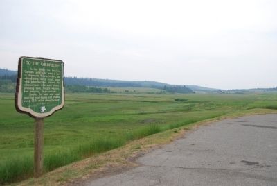
On Provincial Highway 97 23.3 kilometers south of 150 Mile House, on the right when traveling south.
In the 1860s, the fabulous Cariboo goldfields were a lure to thousands. Miners, traders, and adventurers, many afoot, some with wheelbarrows, shared the pioneer route with mule trains, plodding oxen, freight wagons, and swaying stage-coaches. . . . — — Map (db m8857) HM
English:
A search for the source of placer gold found on lower parts of the Fraser River led to discoveries of lode mines in the Cariboo, of which Williams Creek, is said to have yielded $19,000,000. As a centre of population in the . . . — — Map (db m42712) HM
On Barkerville Highway (Provincial Highway 26) 1 kilometer south of Reduction Road, on the left when traveling south.
This rare example of a 19th century Chinese benevolent society hall conformed to a Chee Kung Tong tradition that placed services to members on the ground floor and formal functions above. With its hostel, kitchen, and meeting and ceremonial spaces, . . . — — Map (db m42533) HM
This overshot water wheel is 16 feet in diameter. It is modeled after wheels and pumps used in the tin mines of Cornwall. The early miners found that the pay gravel often lay 40 to 100 feet under the surface. The wheels were used to pump the water . . . — — Map (db m42710) HM
Built in 1882, this is British Columbia’s oldest surviving courthouse, replacing one which stood here from 1862-1882. By 1918, declining population in Richfield led to the building’s closure. Designated a Provincial historic object in 1945, it was . . . — — Map (db m42763) HM
On Kwah Road West 0.3 kilometers west of Stewart Lake Highway (British Columbia Highway 27), on the right when traveling west.
English:
Simon Fraser and John Stuart established Fort St. James among the Carrier Indians in 1806. Originally a North West Company post, it passed to the Hudson’s Bay Company in 1821. From the beginning an important centre of trade and . . . — — Map (db m42736) HM
On Chilcotin-Bella Coola Highway (Provincial Highway 20) 8.2 kilometers east of Hanceville Cut Off Road, on the right when traveling east. Reported missing.
Norman Lee left his ranch in this valley in 1898 with 200 head on a 1500-mile "beef" drive to the Klondyke gold camps. Five months later, winter forced him to butcher the herd. He loaded the meat on scows, which were lost on Teslin Lake, 500 miles . . . — — Map (db m187944) HM
On Cariboo Highway (Provincial Highway 97) 1.1 kilometers south of Spur Road, on the right when traveling south.
Down river lay the perilous and unnavigable canyon. Up-river the Fraser was swift and strong, but sternwheelers could travel for 400 miles from Soda Creek. Men and supplies embarked here in the 1860's for the fabulous Cariboo goldfields. Later, as . . . — — Map (db m187977) HM
On Front Street (Provincial Highway 97) at Carson Street, on the left when traveling north on Front Street.
Promoted by Perry Collins, the U.S. Commercial Agent in Russia, and dependent on the Western Union Telegraph Company’s money, men and technology for its execution, this early telegraph line roused the enthusiasm of the white residents of . . . — — Map (db m276496) HM
For over half a century the Boyd family operated this haven for man and beast. Here weary travellers found lodging, food, and drink. Here fresh horses were hitched to stage-coaches and miners bought supplies.
This historic road-house, built in 1864 . . . — — Map (db m42766) HM
Near Cariboo Highway (Provincial Highway 97) 2.2 kilometers south of Unity Road, on the left when traveling south. Reported missing.
Plans to complete the Pacific Great Eastern Railroad to Prince George in 1921 failed because instable ground prevented use of the proposed bridge site on the Cottonwood River. Thus construction stopped at Quesnel. As northern expansion continued, . . . — — Map (db m188026) HM
On Southern Yellowhead Highway (Provincial Highway 5) 2.4 kilometers south of Bear Road, on the left when traveling south.
On Nov. 21, 1950, a westbound
train carrying Canadian troops
en route to the Korean War
collided with an eastbound train
near Canoe River, killing 21
people. A telegraph operator
was charged with manslaughter
for the miscommunication and
was . . . — — Map (db m187887) HM
Near Yellowhead Highway (Provincial Highway 16) at British Columbia-Alberta boundary line, on the right when traveling west.
Named after “Tete Jaune”, blond fur trader at Jasper House, this low pass was favoured by Sandford Fleming in his railway surveys of the 1870's. Rejected by the C.P.R., the route was later used by the Grand Trunk Pacific and the Canadian Northern . . . — — Map (db m187943) HM
On Yellowhead Highway (Provincial Highway 16) 24.8 kilometers west of Icefields Parkway (Provincial Highway 93), on the right when traveling west.
[English] This pass was used for brief periods from the mid-1820s to the early 1850s by the Hudson's Bay Company, principally to transport leather, especially moosehides, from the Saskatchewan District to its posts in New Caledonia. . . . — — Map (db m202600) HM
Near Viewpoint Road 0.2 kilometers east of Kinney Lake Road, on the left when traveling east.
In 1942, over 21,000 Japanese Canadians were unjustifiably removed from British Columbia's coast. Despite their protests many men aged 19 to 60+ were torn from their families and sent to road camps like Red Pass. Internees gave 290,238 man-days of . . . — — Map (db m187875) HM
On Caine Drive, on the right when traveling north.
Simon Fraser's men cut the first spruce logs near the junction of the Nechako and Fraser Rivers in 1807 to construct Fort George. Starting near the original fort a century later, Prince George became in the 1940's the centre of the white spruce . . . — — Map (db m187962) HM