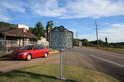
Near here stood Beech Bottom Fort, which was with Fort Pitt and Fort Henry in the group of posts guarding the western borders during the Revolution and its attendant Indian wars. Troops from Fort Pitt helped garrison this important fort. — — Map (db m54915) HM
On land near here was state's first military airfield, home to the West Virginia Flying Corps. Founded in April 1917 by Louis Bennett Jr. and backed by state and private funds, the corps was modeled after the French Lafayette Escadrille with the . . . — — Map (db m176858) HM
Here lived the leading influence in America's largest indigenous religious movement, Christian Church (Disciples of Christ), and founder of Bethany College. Built in four periods: the John Brown Mansion, completed in 1793; Buffalo Seminary, in 1819; . . . — — Map (db m20826) HM
Born in Prince Edward Island, Canada, September 4, 1849
Died December 15, 1920
Fourth President of Bethany College
For thirty-nine years Chief Executive of the
Foreign Christian Missionary Society
Every missionary sent to . . . — — Map (db m20836) HM
Bethany
Here Scots-Irish Alexander Campbell founded a religious movement which he called the Disciples of Christ. In this place Amos Dolbear perfected parts of the telephone, and longtime Speaker of the House "Champ" Clark, Supreme Court . . . — — Map (db m79899) HM
Bethany
Bethany College, established here in 1840, oldest school of college rank in State. The home and the study of Alexander Campbell, founder, are here. Prof. A. E. Dolbear here perfected parts of the telephone, which Bell used.
. . . — — Map (db m79900) HM
Bethany Church of Christ, the oldest church building in Bethany, was built in 1852 according to plans drawn by Alexander Campbell, founder of Bethany College and leader in the Disciples Movement. Its foundation is built of stone from the original . . . — — Map (db m20830) HM
Here are buried the Campbell family; the first missionaries, other prominent leaders in the Disciples Movement, presidents and distinguished teachers of Bethany College. The seven foot hand hewed stonewall is a unique feature of Cemetery. — — Map (db m20963) HM
In this house, 8 Bethany College Students - William Cunningham, John Johnson, Alexander Earle, Richard Alfred, Eugene Tarr, Henry Bell, John Hunt and Jacob Lowe - Met in 1858 and founded Delta Tau Delta. This social fraternity soon spread across the . . . — — Map (db m20849) HM
A major grant from the Renner Foundation, which was matched by alumni gifts, made possible, in 1970, the complete remodeling of Bethany House built in 1948. Henry Clay and James A. Garfield were among the notable guest at the first Bethany House . . . — — Map (db m79901) HM
Born in County Down, Ireland, Feb. 1, 1763, and died at the residence of his son Alexander, Jan. 4, 1851, aged 91 years, 11 mthns, five days. Many years a minister of the Secession Presbyterian Church in Ireland and Scotland. In the United States . . . — — Map (db m20835) HM
Brooke County, West Virginia
World Championship Boxing Match
Joe Goss - Champion
(England, 180 lb., 52 years old)
vs
Patty Ryan - Challenger
(American, 180 lb., 28 years old)
Winner after 87 rounds, Patty Ryan
(Ryan . . . — — Map (db m298963) HM
In honor of each member of all faiths of this community who so heroically served in the Armed Forces and dedicated to the sacred memory of those who sacrificed their lives for democracy, peace and justice — — Map (db m298866) WM
Founded in 1793 by Joseph Doddridge. It is the first Episcopal Church west of the Alleghenies and the oldest continuous worshipping congregation within this religious body in West Virginia. The first church, made of logs, was burned by Indians. . . . — — Map (db m79897) HM
This monument was dedicated by American Legion Post 45 on Memorial Day May 25, 1998 to honor our heroes who served
in World War I - World War II - Korea - Vietnam
Granada - Lebanon - Panama and the Persian Gulf — — Map (db m223836) WM
John Decker built a fort of logs and stone on a site just north of State St. near Ohio River, 1774. Leaden bullets and arrowheads found here on the river bank signify Native American attack on the fort from Mingo Island. — — Map (db m21605) HM
This flag pole is dedicated to the memory of
Joseph "Joey" Perito
who died for our freedom during the Vietnam War in the U.S. Army — — Map (db m223725) WM
Dedicated to the honor and sacrifice of our men and women of Cross Creek District who honorably served our country in all wars
☆ ☆ ☆ ☆ ☆
This memorial is erected in grateful remembrance to those the living . . . — — Map (db m225649) WM
WACs Army •
WAVES Navy •
WAF Air Corps •
AWRS Marines •
SPARS Coast Guard •
WASP Air Service Pilots •
Nurses Corps •
Red Cross Salvation Army •
Gold Star Mothers •
U S O •
Women Defense Workers •
Women Air Raid Wardens — — Map (db m223708) WM
Village of Power. Built to house employees of the Windsor Power Plant, the village of Power consisted of 100 homes along tree-lined streets, a post office, and a company-owned store. There also was a fulltime doctor. Residents gathered at the . . . — — Map (db m285130) HM
In memory of
Joseph Robinson
who made the Supreme Sacrifice
and
the following members of the
Weirton Heights Volunteer Fire Dept.
who served their country in World War II
Ray Poland • John Ritchie • Obie Phebus • Robert De . . . — — Map (db m155999) WM
In memory of those who perished September 11, 2001 during the Attack on America
Steel Beams from the World Trade Center New York City
Weirton Steel Corporation presented these World Trade Center steel beams to . . . — — Map (db m160900) WM
In memory of
William "Bill" Courtney (1950 - 2010)
Husband ~ Father ~ Brother ~ Friend
Patriot
27 years military service
Forever in our hearts
U.S. Navy
U.S. Air Force — — Map (db m155996) WM
Constructed by Alexander Wells at
65 Washington St., Buffaloe, Virginia
(present day Third St.,
Wellsburg, West Virginia)
The Wells Log House was, and is, in the
“National Register of Historic Places”
District of . . . — — Map (db m21634) HM
(Brooke County, Virginia) was built here in 1799 by Samuel Herdman, who lived to see it torn down and re-built in 1849 as the present Brooke County West Virginia Courthouse — — Map (db m189409) HM
First highway tunnels constructed west of Alleghenies. They were built in 1831 by Richard Waugh at personal expense to ease transportation to his flour mills. The tunnels, a mile apart, were removed by the State in 1957. — — Map (db m21614) HM
Dedicated to the men and women from Brooke County who have honorably served in the armed forces of our country in time of war and peace — — Map (db m21616) HM
Born in Wellsburg. January 8. 1819, Tarr opposed Virginia secession in 1861. A staunch Unionist. he was a delegate to the first and second Wheeling conventions, raised Union Troops, and was treasurer for the Restored Government of Virginia. He . . . — — Map (db m189408) HM
Constructed by John Fowler, 1848-51 with bricks fired on the property. First known as Fowler's Inn, the house provided food and lodging for drovers herding livestock over the Wellsburg-Washington Turnpike to eastern markets. Other services provided . . . — — Map (db m42167) HM
George Washington began a journey on October 5, 1770 to the Ohio Country to see lands he had fought to win and now hoped to own. After a trip, on November 3, up the Kanawha River, the party headed back up the Ohio River. On November 17, they reached . . . — — Map (db m33913) HM
Watering trough marks location of first Grimes Golden Apple tree, discovered by owner of land, Thomas Grimes, in 1802. Memorial Trough sponsored by the Franklin Country Women's Club in 1922. — — Map (db m70931) HM
The first glass house in Western Virginia was built at Charlestown, now Wellsburg, in 1813, by Isaac Taylor Duvall and Company. It was located on the southeast corner of Fifth and Yankee Streets. Cobalt blue, green and clear flint glass wares were . . . — — Map (db m285126) HM
Born in Wellsburg in 1824, Duval worked as a scout in the western US and joined the 1849 Gold Rush before returning to Brooke County. He served in the Union Army during the Civil War. rising to the rank of major general. Postwar, Duval served terms . . . — — Map (db m167222) HM
Built by John Henderson prior to 1798 in Federal style, the building was leased by William Miller and operated as a tavern for 50 years. Since 1974 building has housed the Brooke County Museum. — — Map (db m21628) HM
Sergeant on the Lewis and Clark
Expedition, he published the first
account of that exploration in 1807
Veteran of the War of 1812, he
fought in the Battle of Lundy's Lane
and at Fort Erie
Citizen of Wellsburg for more than . . . — — Map (db m21629) HM
Born 12 June 1771, Gass served as carpenter for Lewis and Clark. The expedition explored and studied the land, waterways, animal life, natural features and resources of the West. Gass's journal of trip was published in 1807. Soldier in the War of . . . — — Map (db m39731) HM
The grave of Patrick M. Gass, a sergeant on the Lewis and Clark Expedition and a soldier of the War of 1812 is located in this cemetery. His wife Maria is buried beside him. — — Map (db m54977) HM
The Corps of Discovery, under the command of Meriwether Lewis and William Clark, was the first official expedition through the interior of the North American Continent sponsored by the United States.
Captain Meriwether Lewis passed Charles . . . — — Map (db m21639) HM
Methodism in Wellsburg dates back to 1787 with the establishment of the “Ohio Circuit.” Early services were held in “The Academy” on High Street. Bishop Asbury preached at the courthouse on September 6, 1803.
On April . . . — — Map (db m21635) HM
Four flour mills were constructed near Wellsburg in the early 1800s. The first of these mills was built by John Moore in 1800. Moore's son-in-law, Richard Waugh, built the old stone mill in 1824, and the upper mill in 1835. A. M. Buchanan built the . . . — — Map (db m79898) HM
Established in 1791. Brooke Academy, started, 1778, incorporated in 1799. Here lived Joseph Doddridge, the author of "Frontier Notes," and Patrick Gass, member of the Lewis and Clark Expedition and author of its "Journal." — — Map (db m39699) HM
In the 1790's, flatboats left here with their cargoes for southern markets. To accommodate and store products, warehouses and wharfs were built along our river banks. This wharf, which was established in the 1800's, extended twenty feet out in the . . . — — Map (db m21637) HM
This giant Sycamore tree stands at the top of the Wellsburg Wharf it was planted in the early years of the 19th century by Dr. Albert Wheeler who practiced medicine in Wellsburg until his death in 1864.
It was under this tree that militiamen . . . — — Map (db m21641) HM
One of two tollgate houses erected by the Wellsburg and Washington Turnpike Company in 1834. Served taking tolls on the Pike until 1910. The other tollgate house was located one-half mile east of Wellsburg and was torn down when the Pike was rebuilt . . . — — Map (db m258086) HM
To you from falling hands we throw the torch, be yours to hold it high.
In grateful memory of the sons and daughters of this community who served our country.
Courage • Loyalty • Sacrifice • Victory — — Map (db m269334) WM
Erected in loving memory of the men of Chester, W. Va. who made the supreme sacrifice in World War I and World War II
World War I
Jesse Burge
World War II
Walter Albright • Lawrence Allison • Randall H. Archer • George Arner, Jr. • . . . — — Map (db m269333) WM
Seal of the City of Chester
Collins Memorial Drive
dedicated in loving memory of
Rodney Ray Collins
Chester's only son claimed in Vietnam
May 3, 1948 - October 24, 1969 — — Map (db m269338) HM WM
1938 - Measuring 14 feet high and 14 feet in diameter, the Chester Teapot was constructed by William "Babe" Devon. The Teapot started its life as a gigantic wooden hogshead barrel for a Hire's Root Beer advertising campaign. Devon purchased . . . — — Map (db m269281) HM
Post 6450-Change Of Name
December 2, 2013
From Burge-Casto VFW Post 6450
To
Bob Milby VFW Post 6450
To honor
Robert J. (Bob) Milby
For his
Honesty, integrity and dedication to the post serving as the Quarter Master for 64 years. . . . — — Map (db m269289) HM
Named for natural springs reputedly used by George Washington. Donated in 1857 for picnics and prize fights. Developed in 1897 as amusement park served by streetcar and boat attracting 15-20 thousand daily. Included dance pavilions, shooting . . . — — Map (db m49697) HM
Proud Army Veteran of the European Theater in WW II, earning 3 Bronze Stars, and active member of Chester American Legion Post 121 and Chester VFW Post 6450.
Master carpenter whose work is found throughout the tri-state area, including the . . . — — Map (db m269283) HM WM
State Of Ohio. Named for the river, called by the Iroquois the "Beautiful River Visited by La Salle in 1669-1670. Once part of the Northwest Territory. Settled at Marietta, 1788. Admitted to the Union, 1803 Home of eight United States . . . — — Map (db m288602) HM
POW - MIA
You are not forgotten
United States of America
Department of the Army
1775
United States of America
Department of the Navy
American Legion
US
Post 121
Chester, WV
Est. 1947
United States
Marine Corps . . . — — Map (db m269339) WM
By the Authority of the Veterans of the Foreign Wars of the United States:
Be it Known that Comrades:
Dale K. Allison • Arthur O. Clendenning, Jr. • Eugene Cochran • O. H. Cook • David R. Cooper • John L. Cornell • Brent E. Davis • Richard . . . — — Map (db m269285) HM WM
Site of Nesselroad's powder mill which operated from 1795 to 1801. To the south on King's Creek stood Hartford's grist mill which served local settlers in early 1800's. In 1823, Swearingen's grist mill and Eaton's saw mill were built near the same . . . — — Map (db m39654) HM
On This Spot. On September 18, 1781, Adam Poe and Andrew Poe while freeing white captives, engaged in combat with a war party of the Wyandott tribe and killed the sons of the Wyandott Chief. — — Map (db m39661) HM
Named by boat captains for many brick works shipping from area. John Gamble first mined clay in 1839; James Porter had first brick works in 1832. By 1844, five works produced 1.5 million bricks. Later, some 20 plants: including Captain John Porter, . . . — — Map (db m44118) HM
Named by boat captains for many brick works shipping from area. John Gamble first mined clay in 1830; James Porter had first brick works in 1832; five works in 1844 produced 1.5 million bricks. Later, over 20 plants, using local clay, gas and coal, . . . — — Map (db m44120) HM
Side A:Captain John Porter(August 7, 1838 - February 7, 1893) Early developer of New Cumberland, he operated line of steamboats and barges on Ohio River, Chelsea China Company and glass plants. Known as "brick king" he owned Sligo, . . . — — Map (db m44121) HM
Hancock County, formed in 1848 in home of Sam C. Allison in Fairview, also known as Pughtown and New Manchester. In election for county seat, New Cumberland won by 13; refusal to move led to another vote and majority of 46 in 1850 to move. In May . . . — — Map (db m44124) HM
1862 on Deep Cut a stock company drilled for oil and failed. They did strike a huge natural gas well. People knew little about gas. It roared for two years with a deafening_noise until it was accidentally ignited. Flames shot skyward to over 80', . . . — — Map (db m269277) HM
Flood of 1936. The flood of 1884 was thought to be the great flood at 47' 11". But the 1936 flood crested at 51' 6" on March 18. It was followed by another flood on March 26-35' 9". Over 1,000 citizens were fed at the community house and . . . — — Map (db m269276) HM
Located beside courthouse, original building of four rooms built in 1869, opened in 1870 with town hall on 2nd floor. In 1888 two wings were added. By 20 January 1939, when destroyed by fire, had 14 rooms with 500 students. Rebuilt on same site, it . . . — — Map (db m44126) HM
W. A. Atkinson
Post No. 18 Dep't W. Va.
Grand Army of the Republic
1861 - Veteran - 1866
Appomattox.
Yet loved ones
have fallen
and still where
they sleep
a sorrowing nation shall . . . — — Map (db m269416) WM
World War I
Edmond D. Stewart
Byron Corn
World War II
Arthur Crow • Byron Long • Howard Peterson • Frank Zielinsky • Richard Vulgamore • Dwight Archer • Boaz Blosser • Lawrence Bysarovich • Harold Clark • Harold Mull • . . . — — Map (db m269363) WM
Near New Cumberland, George Chapman settled, about 1783, and built an Indian fort. Here are graves of the Chapmans, Gregorys, Graftons, and other pioneer families. Pughtown, settled about 1810, was the first county seat. — — Map (db m39685) HM
Near New Cumberland, George Chapman settled, about 1783, and built an Indian fort. Here are graves of the Chapmans, Gregorys, Graftons, and other pioneer families. Pughtown, settled about 1810, was the first county seat. — — Map (db m44130) HM
Dedicated to the men and women of New Cumberland who served their country in all wars.
Remembering and honoring those who have fallen.
World War I
Byron Corn • William L. Currant • John K. Moutafes • Edmond D. Stewart
World War . . . — — Map (db m269419) WM
The river flowing past New Cumberland contributed significantly to the political, economic and social development of the town. Early settlers to New Cumberland came by river and then depended on the river as means of receiving supplies and . . . — — Map (db m44133) HM
In 1839 John Cuppy laid out 42 lots on his farm between Ohio River and hill; added 50 lots in 1850. Named Vernon but called Cuppy Town. In 1840 John Chapman built the first house. Industry based on rich clay deposits, brick plants and river . . . — — Map (db m39743) HM
In 1839 John Cuppy laid out 42 lots on his farm between Ohio River and hill; added 50 lots in 1850. Named Vernon but called Cuppy Town. In 1840 John Chapman built the first house. Industry based on rich clay deposits, brick plants and river . . . — — Map (db m44135) HM
Propeller of M. V.
The Clifty Creek
blt 1954. Formerly owned
by C. A. Johnson
given to Swanees Landing
by J-T River Service
1986 — — Map (db m269420) HM
Rockyside. Rockyside was a community of mining and brick making families who lived on the steep hillside just north of New Cumberland along what was then Route 66. The early brickyards attracted workers, many of them Poles or Slavs, who came . . . — — Map (db m269275) HM
Woman's Club Of New Cumberland. Organized in 1933, the Woman's Club of New Cumberland's objective was to promote mental, moral, civic, and social improvement in the The home and community. Their motto is "Unity in Diversity." original 44 . . . — — Map (db m269278) HM
The millstone displayed here is one of the few remaining artifacts from four gristmills located along Tomlinson Run. This stone is a nether millstone. The stationary lower stone, from Hartford's Grist Mill, is 44 inches in diameter. The grooves . . . — — Map (db m269362) HM
On Tomlinson Run, Nesselroad's powder mill began operation about 1795. Near by occurred the famous fight between Andrew and Adam Poe, border scouts, and Chief Big Foot and another Indian in 1782. The Poes won. Two Indians died. — — Map (db m66535) HM
In gratefull remembrance
of
New Manchester's
sons and daughters
who served our country
to preserve freedom
We cannot understand unless we remember
American Revolution Bicentennial 1776 - 1976 — — Map (db m269360) WM
World War I
Raymond Howard • Raymond McCauley
World War II
Dwight Archer • Pete Bobovitch • Cecil Cline • Clem Gadd • Walter Gibas • James E. Graham • Ernest Howell • Earl F. Jones • Frank Knox • Oscar W. Lashley • Charles H. . . . — — Map (db m269353) WM
In 1907, Laurel Hollow Park was created for the benefit of the residents of the then newly formed town, Newell, West Virginia. Unfortunately, it only lasted about six years and would eventually be taken over by wild growth.
George Washington . . . — — Map (db m269354) HM
One of the events which led up to Dunmore's War was the killing at this point of the family of Chief Logan, eloquent leader of the Mingo Indians, April, 1774, opposite their village at the mouth of Yellow Creek in Ohio. — — Map (db m44727) HM
1963 Cyrus Salsberry • Billy R. Stevens • Carl Harris • 1964 John Bumpus • Earl Daugherty • Jack Gourley • 1965 Mervin Summers • Robert Martin • Roy Mayes • James L. Smith • Clarence Jones • Stanley Simcox • 1966 William Simcox • Jack . . . — — Map (db m269440) WM
In July 1863, Confederate Gen. John H. Morgan raided through Kentucky. Indiana, and Ohio seeking to bring the war to the North. Defeated at Buffington Island, he fled up the Ohio River and tried to cross into West Virginia. Members of the state . . . — — Map (db m189407) HM
Developed by subsidiaries of the Homer Laughlin China Company, the town has been home to the world's largest single pottery unit. A key industry in the county and state, fine wares made here have sold around the world. — — Map (db m44730) HM
Rescued from the 1953 Restoration
Donated by
Vernon Betteridge & Doris Durham
This bench has been restored using the
original framework from Laurel Park. — — Map (db m269359) HM
This is the site of the original bears' den which housed two polar bears in 1909.
It was converted to an amphitheater 101 years later through the generous donation of the Newell American Legion Post 114 — — Map (db m269357) HM
On October 27, 2021,
His All-Holiness Ecumenical Patriarch
Bartholomew of Constantinople
and
his Eminence Archbishop
Elpidophoros of America
made a historic visit to the
All Saints Greek Orthodox Church
of Weirton, West Virginia. . . . — — Map (db m269421) HM
In memory of
the nineteen men whose lives were lost in the
Brown's Island Coke Plant Explosion
December 15, 1972
you are not forgotten.
Charles Bowers • Howard Bray • James Brown • Paul Byrne • Michael Crowley • Edward "Dick" Arthurs • . . . — — Map (db m269473) HM
Blessed by Bishop Joseph Hodges of Wheeling
Feast of All Souls, in the year 1977
Built by the people of God of this area,
Acme Marble & Granite Co., Inc. of New Orleans
and Trushel Construction Company of Weirton — — Map (db m269477) HM
In Memory Of
Ernest T. Weir
Founder of
City of Weirton and Weirton Steel
and to the honor of all who have contributed to the growth and progress of the city and its industry
Dedicated in America's Bicentennial Year . . . — — Map (db m155988) HM
460 entries matched your criteria. The first 100 are listed above. Next 100 ⊳