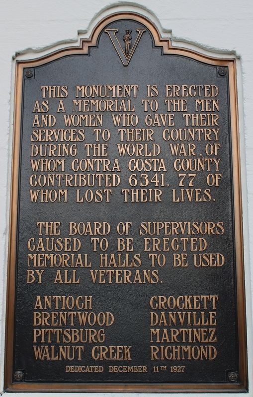
Plaque One:
Dedicated to those from Contra Costa County who served their country in the World War, and to the memory of these who “Gave the last full measure of devotion”
1914 – 1918
Simeon M. Anderson • Adolph C. Bauer, Jr. • Peter . . . — — Map (db m217766) WM
Built in 1905 by Mrs. James Rankin
after fire destroyed two city blocks
Palm Garden Grill
W.C. Reed - Confectioner & Stationer
E. Pasch - Haberdasher
A.B. Wilson - Jeweler & Optician
Historic Marker No. V
Martinez Historical . . . — — Map (db m27647) HM
Grove C. Cook, a native of Kentucky, came to California in 1841 as a member of the Bidwell-Bartleson Party, the first overland emigrant wagon train to set out from the United States to cross the continent to the Pacific Slope.
The party was forced . . . — — Map (db m62419) HM
INDIANS have lived in the greater Bay Area for thousands of years. Black Diamond was located in the backcountry between three tribes: Chupcan (Concord), Volvon (Clayton), and Ompin (Pittsburg). All spoke the Bay Miwok language. With the arrival . . . — — Map (db m198457) HM
William Hook came to the California gold country in 1850 to sell mining equipment and build mining machinery. In 1853 Hook opened a general store at the corner of Ferry and Main Streets in Martinez. Over the years Hook brought up land in Contra . . . — — Map (db m93510) HM
In dedication to the Firefighters who heroically defended Wildlife Waystation throughout the entire December 2017 Creek Fire. Our eternal gratitude for their selfless act of bravery - Cal Fire, Contra Costa County Fire, Los Angeles County Fire Dept, . . . — — Map (db m138093) HM
1885 First Domoto nursery opens in Oakland. The Domotos pioneer California's Japanese American nursery industry and create its wholesale market.
1902 Yataro Nabeta founds the first Japanese American nursery in Contra Costa County, near . . . — — Map (db m146036) HM
In the early 19th century many canneries operated throughout California. The rich agricultural and fishing areas of east Contra Costa County hosted a number of canneries and packing sheds. The picturesque Antioch waterfront was home to two canneries . . . — — Map (db m18292) HM
David and Eliza Glass began their journey west from Iowa in 1850, during the height of the Gold Rush. They arrived in Placerville and after a short time moved on, settling in Alamo. Their son, Clement Rolla Glass, later wrote about their journey: . . . — — Map (db m202053) HM
Miwok Indians inhabited this valley at the base of Mt. Diablo when Spanish explorers came in the 1770’s. Scouts, trappers, prospectors and settlers followed.
In 1857 Clayton was founded by Joel Clayton, a miner, farmer, and wagonmaster from . . . — — Map (db m59954) HM
(front or street side:)
"At four in the morning they would
start preparing the flowers for market.
Grandfather would carefully put the
flowers in a basket and sling it over
his shoulder. Grandmother, carrying
a lantern, would lead him . . . — — Map (db m156299) HM
Located on hiking trail one quarter mile south east
of this point is the intersecting corner of Ranchos
Acalanes, El Sobrante and Boca de la Canada del
Pinole.
Rancho Acalanes
3,329 acres granted to Candelario Valencia
by Governor Jose . . . — — Map (db m178377) HM
History
The Richmond-San Rafael Bridge opened to traffic in 1956, following 2 years of planning and design and 4 years of construction. At the time, its 4.5 mile-length and double-decker design made it one of the most complex bridges in the . . . — — Map (db m223322) HM
Paul De Martini built Clayton Vineyards Winery in 1885 on land formerly owned by Joel Clayton, the area’s first vintner. An Austrian stone mason directed construction, using stone quarried on Mount Diablo and hauled here by wagon teams. This was . . . — — Map (db m312022) HM
Black Diamond Mines Regional Preserve is the site of California's largest coal field. From the mid-1850s to the early 1900s, a dozen mines supplied nearly four million tons of coal to the expanding urban and industrial centers of the San Francisco . . . — — Map (db m197398) HM
This area in the mid 1850s, was a known hideout for legendary bandit Joaquin Murrieta, who worked as a vaquero for John Marsh on his rancho just east of here. It was also frequented by John "Grizzly" Adams, famed California mountain man.
In 1927 . . . — — Map (db m94657) HM
In this cemetery are laid to rest many of the early California pioneers, settlers and their families. One of the more famous is Joseph Reddeford Walker, XNGH - mountain man, guide and pathfinder. — — Map (db m93507) HM
Founded by Dr. Robert Semple in 1847, the Martinez-Benicia ferry was the first established and longest operating ferry service in the S.F. Bay Area. In 1850 Oliver Coffin took over the operation and with his brothers purchased a new ferryboat, the . . . — — Map (db m27645) HM
In 1988, a massive oil spill from the nearby Shell Refinery
inundated the Carquinez Strait and downstream marshes
including McNabney Marsh. As a result of a settlement with
a number of agencies, Shell Oil paid over $12 million into a
Natural . . . — — Map (db m145095) HM
Jose Joaquin Moraga - member of the Juan Bautista de Anza
1776 expedition, founder and first Commandante of the
Presidio of San Francisco - was the grandfather of
Don Joaquin Moraga who with his cousin Don Juan Bernal was awarded this grant in . . . — — Map (db m158344) HM
On this site a school was founded in 1944 to serve
Richmond students. The school was named after
Harry Leander Ells, who served on the Stege
School Board and served the 22nd District of the
State Assembly in 1903-1905 representing Contra
Costa . . . — — Map (db m144416) HM