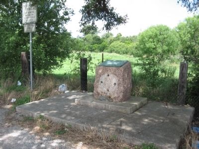
First known to Spanish settlers as Nuestra Senora de Loreto, later called La Bahia del Espritu Santo.
Established as a mission in 1749. Became a strategic fort under Spanish, Mexican, Texas occupancy, 1810-1821, 1835-1836. Name changed to Goliad . . . — — Map (db m34291) HM
On East Broadway Street (U.S. 87) at East Courthouse Street, on the left when traveling west on East Broadway Street.
De Witt County
Included in the colonial grant in 1825 to Green De Witt, Texas empesario ▲ Settled until 1840 largely by Anglo Americans ▲ Created a county of the state of Texas March 24, 1846, its area being taken from Gonzales, . . . — — Map (db m269140) HM
Near State Park Road 27 at Farm to Market Road 2506.
Fannin residents keep the memory of the battle alive
The Battle of Coleto Creek was a harsh loss for the Texians. Although it did not inspire movies and books as the Alamo defeat did, it helped rally the Texian forces a few weeks . . . — — Map (db m192256) HM
On Calle Cinco de Mayo at Camino De Bexar, on the right when traveling south on Calle Cinco de Mayo.
The presidio Nuestra Señora de Loreto was originally established near Matagorda Bay (La Bahía del Espíritu Santo) in 1721 to prevent future French landings in the area and to protect the mission Nuestra Señora del Espíritu Santo de Zúñiga. It was . . . — — Map (db m235084) HM
On North Church Street 0.2 miles south of West Ward Street, on the right when traveling north.
The first Mexican American to attend and graduate from Goliad High School was William Rubio Carbajal. The effort to get him admitted to the high school and receive the same education as Anglo Americans was an important struggle for Mexican Americans . . . — — Map (db m192203) HM
Near State Park Road 27 at Farm to Market Road 2506.
People make the site their own
Improvements to the site were made throughout the 1920s. A two-story bandstand was constructed and dedicated on March 2, 1928. People flocked to the location for community events such as picnics, parties, . . . — — Map (db m192340) HM
On South Market Street north of East Franklin Street, on the right when traveling north.
One of the three first Texas municipalities. Old Aranama Indian village called Santa Dorotea by the Spanish. Presidio La Bahia and Mission Espiritu de Zuniga established 1749. Here early events leading to the Texas Revolution were expeditions of . . . — — Map (db m34142) HM
On Loop 71 at U.S. 183, on the left when traveling east on Loop 71.
In the Spanish colonization system, houses built outside the presidio fort walls by civilians and soldiers' families were intended to become a center of settlement. A diverse population - Spanish, Indian, African and European - flourished around the . . . — — Map (db m235136) HM
On Smith-Walker Cemetery 0.1 miles John Pettus Road, on the right when traveling east.
Virginia native John Freeman Pettus (b. 1808) came to Texas in the early 1820s as a member of Stephen F. Austin's first colony. During the Texas Revolution he served with Ben Milam in the siege of Bexar and participated in the Battle of San Jacinto. . . . — — Map (db m267137) HM
Near Navasota Street north of East 7th Street, on the right when traveling north.
Participated in the disturbance at Anahuac June, 1832 and the storming and capture of Bexar, December 5 to 10, 1835. Born in North Carolina February 20, 1801. Died in Goliad County, Texas March 4, 1881.
Eliza Hancock Shipman Wife of Daniel . . . — — Map (db m25666) HM
On Church Road 0.1 miles south of State Highway 119, on the right when traveling south.
The community of Weesatche began in the late 1840s and 1850s as Middletown. Most early settlers were farmers, ranchers, laborers and of professional occupations, many of them German immigrants or of German descent. When the Methodist church moved to . . . — — Map (db m235023) HM
On Cabrera Road at Barnhill Road, on the right when traveling north on Cabrera Road.
Texan soldiers of Colonel Fannin's command killed and mortally wounded in battle of March 19, 1836 and buried in Texan trenches on the battlefield
Alfred Dorsey • Conrad Eigenauer • John Jackson • John Kelly • William H. Mann • George McKnight . . . — — Map (db m237668) WM
On Lower Mission Valley Road 1.5 miles west of Coffey Lane, on the right when traveling west.
Traditionally recognized as the first great cattle ranch in Texas, Espíritu Santo Ranch traces its history to the Spanish Mission of Nuestra Senõra del Espíritu Santo de Zúniga, established on Garcitas Creek in present Jackson County in 1722. It . . . — — Map (db m208015) HM
On Park Road 6 0.1 miles west of U.S. 183, on the right when traveling west.
Originally established near present Matagorda Bay, Mission Nuestra Señora del Espíritu Santo de Zuñiga was moved to this San Antonio River location in 1749. Here, for more than 70 years, the Franciscan missionaries taught the native Aranama peoples . . . — — Map (db m235186) HM
Near State Park Road 27 at Farm to Market Road 2506.
Historic Markers and Memorials
The creation of what is now the Fannin Battleground State Historic Site began in 1913, when the Hanleys, owners of the land, deeded 10 acres to the state. The next year, a cement wall four feet high . . . — — Map (db m234640) HM
On Calle Cinco de Mayo at Camino de Bexar on Calle Cinco de Mayo.
The Texan victory at the Battle of San Jacinto led to the withdrawal of the Mexican army from Texas. At the end of May 1836, General Thomas Rusk reoccupied Victoria and Goliad. The Centralist soldiers had only partially burned the bodies of . . . — — Map (db m235075) HM
On South Commercial Street, on the right when traveling north.
A cyclone, considered one of the two most disastrous in Texas history, struck Goliad on Sunday, May 18, 1902. The twister touched down on the south side of the San Antonio River at 3:35 p.m. Sounding like a heavily loaded freight train, the storm . . . — — Map (db m34115) HM
On South Jefferson Street (U.S. 183) at Auditorium Drive, on the right when traveling south on South Jefferson Street.
Mississippi native and Goliad County Judge James Arthur White (1878-1953) possessed a fervent interest in Texas history, notably that of his adopted city of Goliad. He began in 1928 to organize support for a state park to protect Goliad's many . . . — — Map (db m122045) HM
Near South Dixie Highway (U.S. 31W) 0.1 miles north of L and N Turnpike Road (Kentucky Highway 335), on the left when traveling north.
(Front Side)
Texas
Remembers the valor and devotion of its sons who served with distinction on Kentucky battlefields during the Civil War.
At Houston, Texas, during August and September 1861, Benjamin Franklin Terry and Thomas . . . — — Map (db m250166) HM WM
On U.S. 59 0.2 miles west of State Highway 239, on the left when traveling west.
The mission remains are not yet fully understood, but archeologists have determined how some of the structures were used.
A. First Chapel
The eastern side of the main structure is believed to have been the first chapel, constructed . . . — — Map (db m235456) HM
On U.S. 59 2 miles west of State Highway 239, on the left when traveling west.
Struggling to overcome cultural differences, the Spanish and native inhabitants of the Texas missions forged connections that would alter the course of Texas history.
Conflict and Cooperation
When the first missionaries arrived, South . . . — — Map (db m235452) HM
On U.S. 59 2 miles west of State Highway 239, on the left when traveling west.
Though today you may only see stone foundations, this was once the site of a lively mission community.
From Glory to Ruins
Ahead of you are the remains of the Spanish Mission Nuestra Señora del Rosario. Established in 1754 to bring . . . — — Map (db m235459) HM
On U.S. 183 0.2 miles north of Farm to Market Road 1961, on the left when traveling north.
Many German and Polish immigrants came to Texas in the 19th century on a ship named Weser. Arriving at the Port of Galveston, a number of the pioneer settlers made their way overland to this area, establishing a community in the 1850s and . . . — — Map (db m122047) HM
On State Highway 72 at North Louis Avenue, on the right when traveling north on State Highway 72.
Created March 24, 1846
from Gonzales, Victoria
and Goliad counties;
Organized July 13, 1846,
with Cuero as the county seat
Named in honor of
Green De Witt
A Texas Empresario
Born in Kentucky September 16, 1797
Died in . . . — — Map (db m131927) HM
Near Park Road 6 0.2 miles west of South Jefferson Street (U.S. 183).
Founded in 1722 by the Aguayo Expedition on "La Bahia del Espiritu Santo" (the Bay of the Holy Spirit), present Lavaca Bay. This mission reflects its former site in the popular name, "La Bahia". Its formal name (in part) honored Baltasar de . . . — — Map (db m116299) HM
Thin black lines indicate changes in relevance. Between each pair of lines entries are ordered geographically but all have the same relevance.
* Inflectional forms of words are their plurals, singulars, and possessives as well as gramatical tenses and similar variations.