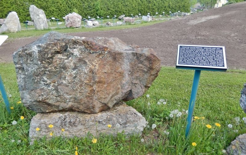
Near Latchford Street just south of Florence Street, on the right when traveling south.
Formed with “metallic inclusions”, this geologic anomaly was put on display at Teck-Hughes Gold Mine by manager George Gilchrist. In 1962 it was extracted from the 3400 foot level by Don Dekker & Al Murphy by way of the South Shaft and an interior . . . — — Map (db m304797) HM
On Sutherland Way just south of Blackwall Street, on the left when traveling south.
[English] The Sisters of Assumption, a congregation of French nuns, were devoted to the teaching of young girls and the Convent was one of the first educational institutions in this northern region. The building is . . . — — Map (db m304593) HM
On Riverside Drive 0.2 kilometers east of May Street South.
English: The Little Clay Belt, the rich agricultural belt extending north from New Liskeard, was originally inhabited by the Algonquin First Nations, including Joachim "Clear Sky" Wabigijic and Angela Lapointe who lived by the mouth . . . — — Map (db m199224) HM
On Whitewood Avenue West at Paget Street South, on the left when traveling west on Whitewood Avenue West.
[English] The Grand Union Hotel was built in 1905 by two Syrian immigrants, Mike Abraham and Dick Zahalan. The hotel was built 4 stories high, with 48 bedrooms, a high class parlour, its own electric plant and . . . — — Map (db m305133) HM
On Farr Drive just north of Marcella Street, on the right when traveling north.
One of the “Ten Worst Disasters in Canadian History” occurred on 4 October 1922. Within six hours ninety percent of the Town of Haileybury was destroyed by a raging bush-fire. Strong westerly winds had thrown burning embers onto the Town and then . . . — — Map (db m304724) HM
On Farr Drive at Broadway Street, on the right when traveling north on Farr Drive.
[English] The First Chartered Air Mail Service and the Haileybury Wharf: The wharf at Haileybury was an active hub for planes, boats and people in the early days. The Laurentide Air Service Ltd. was the first to be . . . — — Map (db m304594) HM
On Farr Drive at Marcella Street, on the right when traveling north on Farr Drive.
At the beginning of the 20th Century, when wood was the main heating fuel, Quebec farmers regularly crossed the ice on Lake Temiskaming with sleigh loads of cord wood drawn by teams of horses. Their goal was to sell the wood to Haileybury . . . — — Map (db m304597) HM
Near Latchford Street just south of Florence Street, on the right when traveling south.
[English] The Inukshuk, symbol of the North, can be found throughout the Arctic. The Inukshuk represents a strong connection to the land and has many purposes. It may give direction to a traveler, mark a cache of . . . — — Map (db m304747) HM
On Georgina Avenue at Main Street, on the right when traveling north on Georgina Avenue.
The City of Temiskaming Shores honours the contribution of the 90 years of continuous charitable service by the women of the IODE Haileybury Chapter (1923-2013) Now part of the history of the area, the Chapter began in 1923 in answer to the needs of . . . — — Map (db m304598) HM
Near Riverside Drive 0.3 kilometers east of May Street South.
Historical Bits Suggested reading: A Boater's Guide To Historic Lake Temiskaming by Peter Fancy available at Haileybury Heritage Museum. Kipawa River Lodge On the north shore of the Kipawa river, at the falls is the Tim-Kip Lodge as it . . . — — Map (db m305203) HM
On Lakeshore Road South 0.3 kilometers north of Latchford Street, on the right when traveling north.
[English] Lake Temiskaming, a freshwater lake is shared by both Ontario and Quebec as it forms part of the provincial border between the two provinces. Created during the last ice age, as the glacier carved its way . . . — — Map (db m304595) HM
On Provincial Highway 65 just east of Trans-Canada Highway (Provincial Highway 11), on the right when traveling south.
[English] The structure of the museum is modelled after the Shepherdson Wood and Basket Works which was originally located on Shepherdson Road. The LCHM represents the homesteaders who developed the area. It is . . . — — Map (db m305154) HM
Near Latchford Street just south of Florence Street, on the right when traveling south.
[English] The principal source of the world's white opals is from the South Australian outback where temperatures exceed 50 degrees Celsius. Miners insulate themselves by living and working beneath the surface. Much . . . — — Map (db m304599) HM
On Lakeshore Road South at Brewster Street, on the left when traveling north on Lakeshore Road South.
[English] Millionaires Row in Haileybury is characterized by stately homes situated along Lakeshore Road looking out on the lake. This section of Lakeshore Road came to be known as Millionaires Row in reference to the . . . — — Map (db m304592) HM
On Beach Boulevard just east of Lakeshore Road North, on the right when traveling north.
[English] New Liskeard was, and still is, well known for its “Mile of Beach” that runs along the north shore of Lake Temiskaming. The Beach in the early days had a grand-stand, racetrack, dance pavilion, . . . — — Map (db m305174) HM
On Whitewood Avenue West at Wellington Street South, on the right when traveling east on Whitewood Avenue West.
[English] Prior to its present location, the local library had various residencies in the town. The building of the New Liskeard Library was facilitated by a grant of $10,000 from the Andrew Carnegie Library Foundation in 1910. The new . . . — — Map (db m195930) HM
On Whitewood Avenue West at Wellington Street South, on the right when traveling east on Whitewood Avenue West.
The New Liskeard Public Library Building was erected in 1910 through the assistance of a grant from Andrew Carnegie. Local limestone was used in the construction and it remains a classic example of the Carnegie libraries. Much of the original . . . — — Map (db m195929) HM
On Riverside Drive 0.2 kilometers east of May Street South, on the right when traveling east.
[English] Northern Farm Country As with many northern Ontario towns, the Town of New Liskeard was shaped by geography and geology. In the wake of the glaciation era, some 10,000 years ago, rich deposits of clay . . . — — Map (db m305295) HM
Near Farr Drive at Main Street, on the right when traveling north.
[English] Ottawa River A bird's-eye-view of the Ottawa Valley illustrates its most important natural feature the Ottawa River. One of the great rivers on the continent and the second largest in eastern . . . — — Map (db m304788) HM
On Riverside Drive 0.2 kilometers east of May Street South, on the right when traveling east.
[English] Ottawa River A bird's-eye-view of the Ottawa Valley illustrates its most important natural feature the Ottawa River. One of the great rivers on the continent and the second largest in eastern Canada, . . . — — Map (db m305180) HM
Near Latchford Street just south of Florence Street, on the right when traveling south.
[English] The Haileybury School of Mines began in 1912, offering part time classes, as part of the regular curriculum of the Haileybury High School. The school is currently under the direction of Northern College and . . . — — Map (db m304596) HM
Near Farr Drive at Main Street, on the right when traveling north.
[English] Settlement and Conflagration Charles Cobbold Farr, chief trader at the Hudson Bay Company's Fort Temiskaming, in 1883 purchased 30 acres of land known as Humphrey's Depot. Natives had originally named . . . — — Map (db m304795) HM
On Riverside Drive 0.2 kilometers east of South May Street, on the right when traveling east.
[English] Staking a Claim The Town of New Liskeard is situated at the mouth of the Wabi River where it flows into Lake Temiskaming, a location long known as a haven from storms. This was once the seasonal . . . — — Map (db m305256) HM
Near Latchford Street just south of Florence Street, on the right when traveling south.
[English] This sculpture, from a set of six, was originally mounted on the William H. Wright building in Toronto, home of the Globe and Mail Newspaper. In 1974 when the Wright building was demolished, the Globe and . . . — — Map (db m304781) HM
On Whitewood Avenue West just west of Wellington Street South, on the left when traveling west.
[top tablet]In honored memory of the men of New Liskeard and vicinity who gave their lives in the Great War 1914-1918S. Alberta • R. Arnold • E. Arnold • B. Armstrong • L. Bass • G. H. Ball . . . — — Map (db m305296) WM