On Webster Street at Deeds Park Drive, on the left when traveling north on Webster Street.
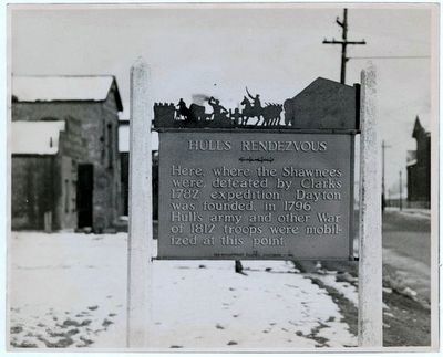
Here, where the Shawnees were defeated by Clark's 1782 expedition, Dayton was founded, in 1796. Hull's army and other War of 1812 troops were mobilized at this point. — — Map (db m36365) HM
On North Main Street (U.S. 68) at Miami Street (U.S. 36), on the right when traveling south on North Main Street.
This tablet mark's the Site of Doolittle's Tavern, Headquarters of Gov. Meigs during the quartering of Gen. Hull's Army at Urbana in the War of 1812. — — Map (db m19798) HM
On North Detroit Street (U.S. 68) at Columbus Street, on the right when traveling north on North Detroit Street.
Hull's Trace. A trail over which General Hull's army marched to Detroit in 1812. At this point a company of scouts recruited by Capt. Wm. McColloch of Zanetown joined Hull's army.
Moluntha. Chief Moluntha, Grand Sachem of the . . . — — Map (db m198041) HM
On County Road 91 west of County Road 130, on the left when traveling west.
Hull's
Army In 1812
encamped on this land
owned by
Col. James McPherson
a Revolutionary Soldier
who lies buried in the
adjoining cemetery — — Map (db m58638) HM
On County Route 39, 2.5 miles north of Ohio Route 274, on the right when traveling south.
[North Side of Marker]
Named for a Wyandot Chief. Once home of Chief Tarhee. During American Revolution was headquarters of renegade Simon Girty who brought Simon Kenton here after saving his life in 1778. Hull camped here in 1812. . . . — — Map (db m34246) HM
On Lynn Valley Pike, 0.2 miles south of County Route 106, on the left when traveling south.
Approximately 1000 feet east of this marker lies the graves of sixteen American soldiers from Fort McArthur who gave their lives during the War of 1812. The fort, a one-half acre timber stockade containing huts, was built in the summer of 1812 to . . . — — Map (db m22250) HM
This Tablet marks Hull’s Trail; 1812. One-half mile south of this is the site of Old Fort McArthur. Built in 1812 on yonder hillside, Gen. Tupper and 1,000 men camped the entire winter of 1812-13. At the foot of the hill is their “Spring of . . . — — Map (db m18416) HM
On State Route 701 (Ohio Route 701) at County Road 135 (County Route 135) on State Route 701.
Hull’s Trail was a rough passageway through Ohio to the Canadian border, used by General William Hull’s army during the War of 1812 on its way to attack the English at Detroit. Woodsmen cleared the trail to permit the Ohio Army Militia with its . . . — — Map (db m18464) HM
On S. Main Street (Ohio Route 12), on the right when traveling south.
[Marker Front]:
Early in the War of 1812, Gen. Wm. Hull, commander of Ohio troops, ordered Col.. James Findlay to open a road from Ft. McArthur on the Scioto River to Blanchard’s Fork. Under Findlay, a stockade 50 yards square, with a . . . — — Map (db m19335) HM
On US Turnpike Road, 0.3 miles north of Strong Road, on the right when traveling north.
General Hull's army hewed out of the wilderness the first Michigan road when it advanced from the River Raisin to Detroit at the beginning of the War of 1812.
In Monroe the original crossing of the river by Hull's Army was at a ford near the . . . — — Map (db m164706) HM
On South Gibraltar Road, 0.1 miles east of West Jefferson Avenue, on the right when traveling east.
In this vicinity on Aug. 5, 1812, six weeks after the outbreak of war, an Indian force, led by the famous Shawnee chief, Tecumseh, ambushed about 200 Americans under Major Thomas Van Horne who were on the way south to the River Raisin. There, . . . — — Map (db m182549) HM
On South Gibraltar Road, 0.1 miles east of West Jefferson Avenue, on the right when traveling east.
[First Tablet, Lower Tablet Facing East]:
War of 1812 Memorial
Dedicated on Aug. 5, 2006
Original monument was dedicated
In 1908 at W. Jefferson Ave.
Near Gibraltar Road by
Dr. Hal C. Wyman
Moved in 1958-1959 to . . . — — Map (db m182550) WM
On West Jefferson Avenue, 0.4 miles south of Slocum Street, on the right when traveling north. Reported missing.
Battle of Monguagon
On August 9, 1812, a force of about 600 American troops, regulars and militia, moved down the River Road in an attempt to reach Frenchtown (Monroe) and bring back supplies needed desperately by the Americans in Detroit. . . . — — Map (db m182553) HM
On Shelby Street at West Fort Street (Michigan Highway 85), on the right when traveling south on Shelby Street.
This marks the site of the southwest bastion of Fort Lernoult. It was here, on July 11, 1796, that the American flag was first flown over Detroit. The fort was built by the British in 1778-79 to protect Detroit against the possibility of attack by . . . — — Map (db m21736) HM
On 2072 Riverside Drive East west of Walker Road, on the left when traveling east.
On July 4, 1812, Brigadier-General William Hull, commander of the North Western Army of the United States, landed with about 2,000 men near this site. He issued a proclamation stating that he came here to liberate Canada from oppression. The British . . . — — Map (db m34302) HM
On Pitt Street West west of Ferry Street, on the right when traveling west.
This house and adjacent farmland were the property of François Baby (1763-1856), first member for Kent in the Legislative Assembly of Upper Canada (1792-96), militia officer and Assistant Quarter Master General during the War of 1812. When the . . . — — Map (db m34303) HM
On Sandwich Street at Ojibway Parkway, on the right when traveling south on Sandwich Street.
Confident of victory, General Hull had invaded Canada in July 1812, but failed to take advantage of his early success and the demoralization of the defenders. Fear of the Indians then rallying to the British cause and an inability to maintain supply . . . — — Map (db m34321) HM
On Front Street North (Provincial Highway 20) north of North Side Road, on the right when traveling south.
In the War of 1812, the first engagement in Canada involving British and American forces in significant numbers occurred here on the Canard River. On July 12, 1812, Brigadier-General William Hull invaded Canada and encamped near Sandwich. British . . . — — Map (db m34336) HM