By Mark Hilton, March 6, 2019
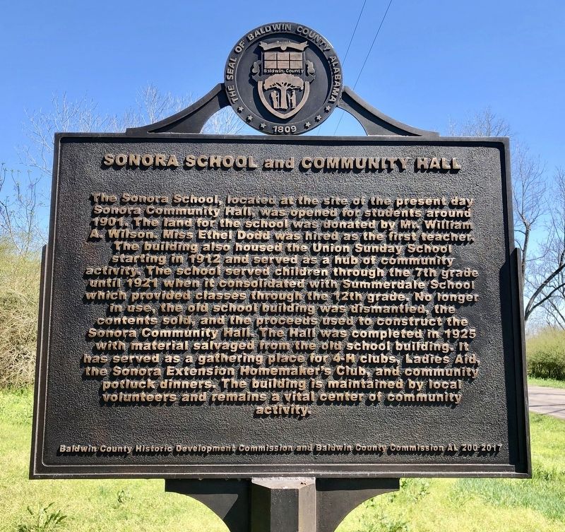
Sonora School and Community Hall Marker
GEOGRAPHIC SORT Title Sort Marker Number Sort Marker Number Sort N Marker Number Sort T Publication Order Sort Publication Order Sort A Erected Year Sort Most Viewed Sort Most Recent-Interest Sort Most Recently Changed Sort SEE FAQ #33 FOR DESCRIPTIONS
On County Road 32, 0.2 miles west of Sherman Road, on the right when traveling west.
Near Summit Bridge Road (Delaware Route 71) 0.4 miles south of Green Giant Road, on the left when traveling south.
Near Constitution Avenue Northwest (U.S. 1/50) at 12th Street Northwest, on the right when traveling east.
On Jefferson Drive Southwest west of 12th Street Southwest, on the right when traveling east.
Near Stadium Road, 0.2 miles west of Newell Drive.
On Unnamed Road, 0.3 miles east of Rock Eagle Road, on the left when traveling east.
On Rock Eagle Road NW at Unnamed entrance road to 4-H Center, on the right when traveling north on Rock Eagle Road NW.
On West Madison Street just east of La Salle Street (Illinois Route 23), on the left when traveling west.
On South 16th Street (U.S. 71) south of Essie Davison Drive, on the left when traveling south.
On 16th Street / Glenn Miller Avenue (U.S. 71) south of Essie Davison Drive, on the left when traveling south.
On South 16th Street (U.S. 71) south of Essie Davison Drive, on the left when traveling south.
On U.S. 56, on the left when traveling east.
Near Detour Road, 0.4 miles east of Harmony Road (Maryland Route 16), on the right when traveling east.
Near Detour Road east of Harmony Road (Maryland Route 16), on the right when traveling east.
Paid Advertisement
Near Detour Road east of Harmony Road (Maryland Route 16), on the right when traveling east.
Near Connecticut Avenue (Maryland Route 185) south of Thornapple Street, on the right when traveling south.
Near Connecticut Avenue (Maryland Route 185) south of Thornapple Street, on the right when traveling south.
On Brooke Road, 0.1 miles west of Chandlee Mill Road, on the right when traveling west.
Near 7th Avenue West east of Douglas Street, on the right when traveling east.
On 1st Street north of Peters Avenue, on the left when traveling north.
Near S. Main Street at W. Russell Street.
On West Franklin Street (State Highway 84) east of South Robinson Avenue, on the left when traveling east.
Near North Nebraska Avenue at 4-H Drive, on the right when traveling north.
Near Lake Avenue (New York State Route 78) 0.5 miles north of Old Niagara Road.
On North Academy Street (U.S. 13) at Main Street, on the left when traveling north on North Academy Street.
On U.S. 36, on the right when traveling west.
On Limestone Street, on the left when traveling north.
On North Limestone Street (Ohio Route 72) just north of White Cliffs Court, on the right when traveling south.
On Limestone Street, on the left when traveling north.
Paid Advertisement
On Limestone Street at Columbia Street, on the left when traveling north on Limestone Street.
On Cheshire Road at Old State Road/Lackey Old State Road, on the right when traveling west on Cheshire Road.
On Fred Taylor Drive at Borror Dr., on the left when traveling north on Fred Taylor Drive.
On County Road MN, 0.1 miles east of Harrison Lake Road, on the left when traveling east.
On County Road MN, 0.1 miles east of Harrison Lake Road, on the left when traveling east.
On County Road MN, 0.1 miles east of Harrison Lake Road.
On U.S. 36 at Alcony-Conover Road (County Route 26), on the left when traveling east on U.S. 36.
On U.S. 36, 0.7 miles west of Elm Tree Road North (County Road 21), on the right when traveling west.
On Henry M. Turner Street at Cedar Lane, on the right when traveling east on Henry M. Turner Street.
On Johnston Highway (State Highway 191) 0.2 miles north of State Highway 19, on the right when traveling south.
On Earlysville Road, 0.2 miles south of Woodlands Road, on the right when traveling south.
On McKenney Highway (Virginia Route 40) at Old White Oak Road (County Route 610), on the right when traveling west on McKenney Highway.
Near West Ox Road (Virginia Route 608) west of Rogers Lane, on the right when traveling west.
Near 4H Camp Road (County Route 76) 1 mile north of Goshen Road (County Route 77), on the left when traveling north.
Near 4H Camp Road (County Route 76) 1 mile north of Goshen Road (County Route 77), on the left when traveling north.
Paid Advertisement
Near 4H Camp Road (County Road 76) 0.4 miles north of County Road 76/1, on the left when traveling north.
On 4H Camp Road (County Route 76) 0.9 miles north of Goshen Road (County Route 77), on the left when traveling north.
Near 4H Camp Road (County Route 76) 1 mile north of Goshen Road (County Route 77), on the left when traveling north.
On 4H Camp Road (County Route 76) 1 mile north of Goshen Road (County Route 77), on the left when traveling north.
Near 4H Camp Road (County Road 76) 1 mile north of County Road 76/1, on the left when traveling north.
Near 4H Camp Road (County Route 76) 1 mile north of Goshen Road (County Route 77), on the left when traveling north.
On 4H Camp Road (County Route 76) 1 mile north of Goshen Road (County Route 77), on the left when traveling north.
On Old Yorkville Road at 63rd Road, on the right when traveling west on Old Yorkville Road.