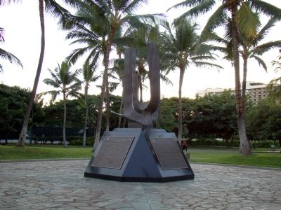
Honoring the World War II Veterans of the 100th Infantry Battalion (Separate), the 442nd Regimental Combat Team, the Military Intelligence Service, and the 1399th Engineer Construction Battalion.
“Veterans who served in these units, . . . — — Map (db m26939) HM
(tablet on back of base)
David Kalākaua was born on November 16, 1836. He succeeded to the throne on February 12, 1874, and ruled with his queen, Kapi‘olani. King Kalākaua was the catalyst for the revival and flowering of . . . — — Map (db m13586) HM
Ancient Hawaii was governed by a sharply defined caste system. The kings were the highest authority. Chiefs, or Alii, ruled over sections of the land at the pleasure of the kings. At times there was a king for each of the major islands in the . . . — — Map (db m75626) HM
A hybrid between a False Killer Whale & Atlantic Bottlenose Dolphin.
Born May 15, 1985.
She shows her whale heritage in her dark coloration, bodylength, width, and large teeth.
Her profile is unique blend of both parents with a short, . . . — — Map (db m82138) HM
St. Philomena Church is the only remaining building from the early settlement at Kalawao. The original church on this site was built by Brother Victorin Bertrant in 1872, about a year before Father Damien arrived at the settlement. Assisted by . . . — — Map (db m184696) HM
Father Damien recognized the special needs of children at the settlement. In 1886 he organized a home for boys. By 1894 the home included 29 separate structures on this site. The line of tall palms bordering the far side of this field marked the . . . — — Map (db m184697) HM
This 1926 Hanalei School classroom building was designed by architect John Waiamau. Scheduled for demolition in 1987, it was moved to the present site and adapted to a new retail use in 1989. The restored building is on the National Register of . . . — — Map (db m27062) HM
The Waioli Mission Hall was established by American Christian missionaries in 1834. A pole and thatch meeting house was constructed by Hawaiians on this site, in anticipation of the arrivals of the missionaries. The first meeting house was destroyed . . . — — Map (db m9804) HM
Houola (dew of life) is the name passed down from ancient times for this place at the mouth of the Wailua River. Historical accounts suggest a pu'uhonua (place of refuge) was located here where one could escape punishment and find safety . . . — — Map (db m65754) HM
The mountain ridges of Maunakapu and Nounou divided the Wailua ahupua'a into two sections. Wailua Kai, traditionally referred to as, "Wailuanuiaho'ano," encompasses about 2800 acres of land seaward. Wailua Uka is comprised of more than 17,455 acres. . . . — — Map (db m65795) HM
Many generations ago, every stone was brought by hand up to this bluff from the rivers below to build this heiau (temple). A heiau was often remodeled by a new ruling ali'i (chief) and his kahuna (priest).
Within . . . — — Map (db m65809) HM
Roxy Square stands on the lot where the largest movie theater in the islands was built by W.A. and Agnes Scharsch Fernandez in 1939. Designed by the well-known Honolulu architect C.W. Dickey, it was modeled after the famous Roxy Theater in New York . . . — — Map (db m40423) HM
The 15-foot cast concrete lantern was constructed in 1915 by Kaua‘i’s first generation Japanese immigrants. As a tribute to their homeland, the lantern commemorates the 1912 coronation of Emperor Taisho. An inscription reads: “Great Japan . . . — — Map (db m9786) HM
Steeped in Hawaiian oral traditions, Wai'ale'ale mountain represents the piko or navel of Kaua'i. Its peak, Kawaikini is the highest point on the island at 5,243 feet. Reputed as one of the world's wettest spots, it average 400 to 600 inches of . . . — — Map (db m65794) HM
May the glimmer of both this historic lighthouse, guiding ships to safe harbor, and the legacy of Senator Daniel K. Inouye, illuminating the voices of Hawaii citizens, always continue to serve as beacons of hope.
'Ike vision, Lawelawe . . . — — Map (db m65776) HM
Buddhist temples provided Japanese immigrants a place to worship, study their language, learn martial arts and participate in social events. This Jodo Mission used a specialist in temple architecture from Japan to build the large temple’s interior. . . . — — Map (db m13007) HM
Kōloa Missionary Church sanctuary is part of a homestead once owned by Dr. James W. Smith, a medical missionary. In 1842, he began a practice of over 40 years, later becoming an ordained minister at The Church at Kōloa. His grandson, Dr. . . . — — Map (db m13023) HM
The Beginning. Near this site, on September 12, 1835, William Hooper began clearing 12 acres of land to plant sugar cane. The land was part of 980 acres leased by Hooper’s employer, Ladd & Co. of Honolulu. The land was leased from King . . . — — Map (db m18760) HM
Built at the turn of the 20th century, The Yamamoto Building functioned at various times as a plantation camp store and general store with service station. Behind it, the Kōloa Hotel offered rooms to traveling salesmen and actors. The o-furo, . . . — — Map (db m13010) HM
Spouting Horn Park was called puhi, or blowhole, by early Hawaiians. Legends tell of a huge mo‘o, or lizard, caught in this puhi, which was formed when waves eroded softer, underlying rocks and wore through the harder top rock. Water rushing into . . . — — Map (db m12764) HM
In the mid 1800s, Kōloa Landing was the third largest whaling port in all of Hawai‘i and the only port of entry for foreign goods. The sugar industry increased its use until 1912, when better facilities became available. Up to 60 ships a year . . . — — Map (db m12787) HM
Lava rock walls near Hapa Road signify Hawaiian habitation ca. 1200 A.D., while the road dates to the late 1880s. Nearby tracks once held trains hauling cane to Kōloa Plantation for milling. Hapa Road served as a supply and emergency evacuation . . . — — Map (db m12866) HM
Stone and coral tools found a Keoneloa Bay , or long sand, helped arcaeologists determine that early Hawaiians used the area between 200 and 600 A.D. as a temporary fishing camp. Later Hawaiians left remnants of heiau, or temples, and ahu, or . . . — — Map (db m12806) HM
The walled heiau (temple) that once stood here was 130 feet by 90 feet; dedicated to Kāne, a major god of Hawai‘i, Hulokoki, a bird god, Kū-hai-moana and Ka-moho-ali‘i, two shark gods. Three hala-lihilihi-‘ula trees situated on the outside . . . — — Map (db m12803) HM
The eastern sand dunes of Makawehi, calm face, and Pā‘ā, hard rock, yield fossilized plant roots, bird bones, crab claws and other treasures. Prior to extensive wave erosion, this prominent limestone ridge extended across Keoneloa Bay. . . . — — Map (db m12859) HM
What began as a hobby garden by the Kōloa Plantation manager’s wife became celebrated as one of the world’s best of its kind. Numerous cactus planted in the 1930s thrived in the arid, rocky soil here. Many escaped to surrounding areas to become . . . — — Map (db m12797) HM
Abundant, easy-to-view marine life in calm waters is a major attraction at Po‘ipū Beach. The endangered native Hawaiian Monk seal and threatened Green sea turtle are frequent visitors. From November through May, the endangered Humpback whale . . . — — Map (db m12805) HM
Prince Jonah Kūhiō Kalaniana‘ole was born in a grass hut near this spot to Princess Kinoike Kekaulike and High Chief David Kahalepouli Pi‘ikoi. He became a delagate to U.S. Congress after Hawai‘i became a Territory in 1900, serving for 19 . . . — — Map (db m12778) HM
More than 5 million years ago, a hotspot in the earth spewed lava upward to form the volcanic mountain island of Kaua‘i. Nearby Hā‘upu Ridge and Mountain contain some of the oldest geologic formations. Look for the youngest volcanic cones, such . . . — — Map (db m12864) HM
The bay before you—named Keoneloa (or ‘the long sand’)—is the site of one of the oldest known Hawaiian occupation on Kaua‘i, a temporary fishing camp, dating to A.D. 220–660.
The Hawaiians divided each island into . . . — — Map (db m12807) HM
You are now standing at what was – for a few months in 1816 and 1817 – the site of a Russian fort named for the Emperor Alexander. How a fort came to be built here, what became of it, and how this part of Kaua'i later got the name . . . — — Map (db m65811) HM
In 1942, Albert S. Morgan, Sr. a native Hawaiian, married Helen Farias and raised five children. The family lived in the community of Wailua where Mr. Morgan served a term as president of the Wailua House Lots Community Association.
As the . . . — — Map (db m40453) HM
In January, 1778, two ships under the command of British navigator Captain James Cook sighted the northwest coast of O'ahu. The next day they cruised from Maha'ulepu to Waimea Bay on Kaua'i where they set anchor. Acquainted with the Tahitian . . . — — Map (db m65777) HM
The row of hewn stone along the inner side of the road is a remnant of one wall of a water-course which is said to have been made by the MENEHUNES (Hawaiian dwarves or Brownies)
The stones were brought from Mokihana
There is an old . . . — — Map (db m27646) HM
Fort History
Fort Elizabeth was one of three Russian Forts partially built between 1815 and 1817 on the island of Kauai. Fort Alexander and Fort Barclay were built near the mouths of the Hanalei River on the north shore of Kauai while Fort . . . — — Map (db m65778) HM
< The landscape of Haleakala National Park rises from a lush valley beneath a waterfall at sea level to a red desert of cinder cones here at the volcanic summit of Haleakala. An astounding array of climates and life zones lies in between. Yet the . . . — — Map (db m62199) HM
Kipahulu-Founded 1864-We welcome visitors to this historic, missionary church in Kipahulu. Out of respect for church members, relatives & descendants of those buried in the graveyard, we ask that you treat this religious site with reverence & care. — — Map (db m71842) HM
The landscape of Haleakalā National Park rises from a lush valley beneath a waterfall at sea level to a red desert of cinder cones here at the volcanic summit of Haleakala. An astounding array of climates and life zones lies in between. Yet the . . . — — Map (db m71753) HM
The Nene is a native Hawaiian Goose that lives in the wild on the islands of Hawaii and Maui. This rare State bird is believed to have descended from the Canada Goose, and isolated on these islands for thousands of years, it has evolved into a . . . — — Map (db m71754) HM
Holy Ghost Catholic Church has been placed on the National Register of Historic Places by the United States Department of the Interior — — Map (db m71770) HM
The trail climbs to the top of a volcanic cinder cone for views of the Haleakala Wilderness Area and the highest peaks of the Big Island. At first glance the trail environment seems nothing but barren rock. Yet these rocks are living habitat for . . . — — Map (db m71765) HM
This ranch wall stacked stone by stone in the late 1800s, represents an investment in the land. Stretching for two miles, it guided cattle through the harsh landscape of Haleakala to pasture lands on the east and west sides of Maui. The ranching era . . . — — Map (db m71762) HM
The Hawaiian Islands are very isolated. Colonizing species arrived, against overwhelming odds, by wind, waves, or wings as a small group or flock, or even just a single individual. A species survival depended upon ability to find suitable food and . . . — — Map (db m71756) HM
This monument commemorates the arrival of the Norwegian barque Beta which dropped anchor near this spot on February 18, 1881, and of her sister ship Musca, which arrived in Honolulu May 13, 1881. They brought more than six hundred . . . — — Map (db m73188) HM
A heiau is a Hawaiian religious structure which centralized the ceremonies and rituals of old Hawaii. The construction of a heiau was directed by the highest chiefs or alii and required a great expenditure of organized labor. The ceremonies and . . . — — Map (db m71864) HM
Commonly called ʻĪao Needle, the traditional Hawaiian name for this 2,250 foot high peak is Kūka‘emoku. This peak is known as the phallic stone of Kanaloa, Hawaiian god of the ocean.
During periods of warfare, the peak was . . . — — Map (db m31540) HM
Navigators! Visually, the open ocean is a featureless environment. This makes it difficult to use sight for navigation. Hammerhead sharks can travel vast distances across the ocean by detecting electromagnetic fields around the Earth. . . . — — Map (db m71861) HM
In the distant future, when our descendants ask, tell them here lies the first altar made by Korean American Christians.
Today, when more than three thousand Korean churches in America, along with their members ask, tell them you all are . . . — — Map (db m73191) HM
248 entries matched your criteria. Entries 201 through 248 are listed above. ⊲ Previous 100