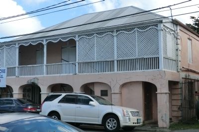
Two story, masonry, residence and shop, with 4 arcades on lower floor and gingerbread trim on second story balcony. Studio of photographer Alex Ovesen and birthplace of Evelyn Richardson. Owners include Samuel Wescott’s children 1864-1950, Wenona de . . . — — Map (db m60817) HM
Along the wharf you would have heard the creaking of rigging and pulleys as ships unloaded foodstuffs, plantation supplies, and building materials. The scent of sugar and molasses sweetened the air. Down the street plodded oxen, snorting with . . . — — Map (db m60815) HM
This building was the third stop in the local chain of commerce. After conducting business at the Scales and Guinea Company Warehouse, merchants and planters paid import and export taxes to Danish customs officials here in the ground-floor . . . — — Map (db m60709) HM
This fort played a vital role in Christiansted’s international trade. Built at harbor’s edge to protect commercial shipping from pirates and privateers, the fort embodied colonists’ fears as well as economic strength. Here were quartered Danish . . . — — Map (db m60707) HM
Since the dawn of consciousness, time has been measured by the movement of the sun. This marker, in the year 2000, is a continuum between all who have come before and all who are yet to come. The design concept starts with the Roman numeral “M”= . . . — — Map (db m60837) HM
This site marks the only point on the United States Territory where members of the crew of Christopher Columbus came ashore on his second voyage to the New World in November 1493. It also relates to the first recorded altercation between . . . — — Map (db m60782) HM
This building was the first Danish Lutheran church on the island—one of the few government buildings not directly involved in international trade. From 1754 to 1831 the Steeple Building was the embodiment of the Danish state religion. All . . . — — Map (db m60711) HM
Eighteenth Century Danish Customs House with nineteenth century addition of the 2nd story gallery. Owner is V.I. Government. Little Altered and in good condition. — — Map (db m60873) HM
The Virgin Islands government had proposed a territorial park for the Reef Bay region of St. John as early as 1937. This led to feasibility studies by the U.S. Department of the Interior to determine if the resources of St. John warranted the . . . — — Map (db m60712) HM
In 1956 Laurance S. Rockefeller, financier and conservationist, donated over 5,000 acres through the Jackson Hole Preserve for the establishment of Virgin Islands National Park. While sailing the Caribbean in 1952, he became enchanted with the . . . — — Map (db m60713) HM
Private philanthropy has a long history and important role in the development of America’s National Park system.
Charitable donations by the Rockefeller family, notably by Laurance S. Rockefeller, helped to establish, enlarge or improve . . . — — Map (db m60716) HM
This bread oven trapped heat from charcoal in the chamber to bake bread slowly in the oven. Enslaved
people and their emancipated descendants burned hard wood in a pit elsewhere to create charcoal as a
more even heat source for this oven and . . . — — Map (db m291780) HM
In 1935, Herman Creque bought the Annaberg Plantation from Carl Francis, the son of
George Francis. Creque's heirs sold the property to Laurance Rockefeller's Jackson Hole
Preserve in 1954. Two years later, the preserve transferred the iconic . . . — — Map (db m291804) HM
Peter Oxholm designed the plans for the Annaberg sugar factory and windmill in 1797. Enslaved African craftsmen constructed the buildings while the plantation was under the ownership of "slave trader, merchant, and shipbuilder" James Murphy. The . . . — — Map (db m291782) HM
You are looking north towards the British Virgin Islands (BVI), a beacon of freedom for enslaved people on St. John during the mid-1800s.
On August 1, 1834, a massive uprising of enslaved people forced King William IV of Great Britain to . . . — — Map (db m291789) HM
Throughout its history, Annaberg's enslaved residents engaged in a struggle for power and
dignity. The planter class fought to dehumanize and control them in pursuit of profit.
Annaberg's legacies call us to reflect on the conditions that . . . — — Map (db m291781) HM
George Francis was born into slavery on Annaberg Plantation during the first decade of the 1800s. When he was enslaved, Francis gained influence that gave him opportunities beyond the reach of the other enslaved people. After inheriting two acres . . . — — Map (db m291778) HM
The sugar boom created an economy built on the brutal enslavement of human beings. The strength, experience, and intelligence of enslaved people guided every aspect of sugar production from cultivation to refinement. Beginning with piles of sugar . . . — — Map (db m291786) HM
The building you are standing in once housed a complete sugar factory. The extracted cane juice flowed from the windmill or animal mill, through gutters, and into this boiling room.
Each sugar factory operation required an artisan "sugar . . . — — Map (db m291784) HM
As you wander the ruins, picture the thriving 18th-19th century sugar factory: big rollers crushing the cane, juice pouring down to the boiling room, and everywhere the thick scent of rum and molasses. This was the Danish plantation era, when . . . — — Map (db m60776) HM
Intense heat. Steam rising from huge cauldrons. A foreman shouting to watch the last copper. This empty ruin was once the heart of Annaberg’s sugar operation.
Workers ladled the cane juice from kettle to kettle, gradually concentrating and . . . — — Map (db m60781) HM
When the breeze died, mules, horses or oxen plodded an endless circle in the sun while slaves fed cane to the rollers. A box at the base caught and held the juice until the factory called for more.
In the early 1900’s, after the sugar . . . — — Map (db m60780) HM
Primarily used for sleeping and household storage, typical “wattle and daub”’ huts with woven stick walls (wattle), dirt floors, and tyre palm roofs comprised Annaberg’s slave quarters on the slope below. The exteriors were plastered (daubed) . . . — — Map (db m60777) HM
If there was a steady breeze, cane was brought to the windmill. Revolving sails turned a central shaft, rotating the rollers and crushing the stalks. Juice ran down the rollers into the gutter and flowed downhill to the factory.
The windmill, as . . . — — Map (db m60779) HM
In Commemoration of the visit
to the Virgin Islands
— of —
Mrs. Lyndon Baines Johnson
Here in Emancipation Park on
June 2, 1965
America's First Lady addressed
the people of St. Thomas — — Map (db m40458) HM
Built in 1874 to replace a wooden
structure, this neo-classical building
served as a military barracks for Fort
Christian. It later housed the Charlotte
Amalie High School, and today the
Virgin Islands Legislature. A grand
staircase with . . . — — Map (db m193621) HM
A Brief History…
Fort Christian, at the grand age of 326 years, is the oldest standing structure in continuous use in the Virgin Islands and the oldest Danish fortication under the American flag. In 1977, Fort Christian was designated a . . . — — Map (db m40333) HM
In 1666, the same year that the Danish West India Company took possession of St. Thomas, this congregation was founded by Pastor K.J. Slagelse as an outpost of the Evangelical (Lutheran) State Church of Denmark. Worshipping at first in private . . . — — Map (db m40615) HM
Built before 1725, the Frederick Church Parsonage is one of the oldest homes on St. Thomas in continual use since construction. It is situated next to Government House and directly north of Frederick Church and Fort Christian. Its location bears . . . — — Map (db m229190) HM
In the Virgin Islands there landed on 4 April 1607 for a stay of 3 days, a company of 144 Englishmen bound for Virginia. On 13 May 1607 that same group founded at Jamestown, Virginia, the first permanent English settlement beyond the British . . . — — Map (db m193617) HM
In the late 1600s detractors of the Danish Colony referred
to St. Thomas with justification as "The Den of Pirates".
Pirates performed acts of bloody violence. Times glossed over their
crimes and imbued them with romance. Titillating legends . . . — — Map (db m193622) HM
1904 1969
This Bandstand is Dedicated
to the memory of
David E. Monsanto
Bandmaster
St. Thomas Community Band
1935 - 1969
Pursuant to the Act. No. 2804 Bill No. 4534
8th Legislature of the V.I. of the U.S.
His was a life of . . . — — Map (db m40457) HM
Dedicated To You, A Free Citizen In A Free Land
This reproduction of the Liberty Bell was presented to the People of the
Virgin Islands
By the direction of
The Honorable John W. Snyder
Secretary of the Treasury
It was the . . . — — Map (db m40456) HM
The St. Thomas Reformed Church is the oldest congregation in the Virgin Islands and a member of the oldest denomination with a continuous ministry in the United States. Organized by Dutch traders, the first European settlers, as the St. Thomas . . . — — Map (db m193619) HM
Originally built as a private home in Danish Manor style, it was acquired by Frederick Church in 1908.
Bethania has been used by the congregation as a home for the aged and parochial school. It has served the community as a post office and . . . — — Map (db m193618) HM
United States Army [Emblem]
Edwin O. Hendricks, 1946 - Army
Alberic M. Daniel, July 31, 1946 - Army
Bromley E. Berkley, October 14, 1952 - Army
Viggo E. Sewer, February 05, 1953 - Army
Anton G. Hatchett, March 12, 1954 - Army
John . . . — — Map (db m291806) WM
These buildings shown on the 1837 Hindelberg map, were quarters for enslaved Africans and a part of the former Lange property across the street. Several families resided here and shared the enclosed courtyard and brick oven. — — Map (db m267610) HM
This plaque expresses appreciation and perpetuates the memory of Arthur S. Fairchild long time friend and president of St. Thomas who on December 27, 1946 donated the major portion of Magens Bay Beach and 56 acres of land in perpetuity to the . . . — — Map (db m40461) HM