(two markers are mounted on this kiosk)
Master Traders
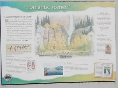
The Lewis and Clark Expedition first met Chinookan tribes as they traveled through the Columbia River Gorge in autumn 1805. At the time, Chinookan society . . . — — Map (db m158244) HM
The rocks project into the river in many places and have the appearance of having fallen from the high hills…
This part of the river resembles a pond partly drained leaving many stumps bare both in & out of the water…
We can plainly hear the . . . — — Map (db m112268) HM
The Legion Park overlook allows a glimpse into the distant past. Here the panoramic view of Port Gardner Bay extends all the way to Mukilteo, and includes views of Smith Island, Priest Point, Camano, Jetty and Gedney (Hat) Islands. On a clear day . . . — — Map (db m135694) HM
Welcome to a walking tour of Mukilteo Lighthouse Park and Mukilteo's historic light station. We hope you enjoy this walk, learning more about Mukilteo and its lighthouse. The tour is fully accessible, and restrooms are located here in the park. . . . — — Map (db m178833) HM
Use of the Spit in Mukilteo
This area is within the traditional territory of the Snohomish who, along with the Snoqualmie, Skykomish and other allied tribes and bands, are Salish-speaking indigenous peoples that lived along the shoreline . . . — — Map (db m178832) HM
"When you're on the water, you know that you're celebrating your ancestors and taking care of your spirit"
-Tulalip tribal member, Sydney Napeahl.
Cedar canoes are the traditional mode of transportation for Coastal Native American . . . — — Map (db m179260) HM
Treaty of Point Elliott, 1855
On January 22, 1855, a treaty was negotiated between the United States Government and the Coast Salish tribes of this area. More than 2,000 Indians gathered here from throughout the Northern Puget Sound . . . — — Map (db m178806) HM
Coast Salish peoples, here for thousands of years before settlers arrived, shared a strong belief in the existence of "myth age," when beings sharing both human and animal qualities roamed the earth. According to legend, a Changer . . . — — Map (db m179253) HM
In 1853, Washington's territorial governor Isaac Stevens identified 30 different Indian tribes in the Puget Sound area. A presidential order directed him to sign treaties with them. The Point Elliott Treaty, signed on this waterfront in 1855, . . . — — Map (db m179257) HM
The Gifts from the Old Growth Cedars
Back 1,000 years ago until the 1880’s, old growth cedar was abundant along the drainages of our streams and the Snohomish River. Just as salmon and marine species played an important role in providing . . . — — Map (db m178754) HM
At this place on January 22, 1855,
Governor Isaac I. Stevens
concluded the treaty by which the
Indians ceded the lands from Point
Pully to the British boundary. Of the
one hundred signatures, eighty-two
were by Indian chiefs, headmen . . . — — Map (db m135450) HM
From the 1940’s – 1960’s, U.S. Indian Policy was Termination. The policy strove for Native American Tribes to sell their lands to the government. The Tribes would disband and “assimilate” into American society, ending their unique . . . — — Map (db m134142) HM
In 1877, the few white people living in Spokane Falls, and settlers from the surrounding area came here for protection because the Nez Perce Indians were on the warpath. They chose this island, then known as Big Island, for defense because of the . . . — — Map (db m154270) HM
Its location on the banks of a major inland waterway, and its strategic access to annual salmon runs, have made the Spokane Falls a gathering place for thousands of years. The Spokane Indians who traditionally occupied the region around Spokane . . . — — Map (db m148641) HM
The Spokane River originates at Lake Coeur d'Alene, flowing about 112 miles through seven dams in its journey west to Lake Roosevelt and the Columbia. For native people, the river provided fish, spiritual sustenance and a gathering place. Today, the . . . — — Map (db m148679) HM
1 1/4 miles north-west
is a bronze tablet
placed by
Sacajawea Chapter D.A.R.
marking site where
Governor Stevens
held council with Nisqually,
Puyallup and Squaxon Indians,
December 24-26, 1854.
This stone erected by
. . . — — Map (db m221682) HM
This site, long the home and hunting ground of the Indian, was first sighted by white man in 1792 when Lt. Broughton was sent by Capt. Vancouver to verify the Gray’s reported discovery of the Columbia, and visited by Lewis and Clark in 1805 on . . . — — Map (db m116586) HM
Geology at Wallula
From 15,000-18,000 years ago what many geologists believe were the Earth's largest floods raced through Wallula Gap. Some of these floods were as many as twenty times as large as the combined discharge of all the world's . . . — — Map (db m182195) HM
The longest battle in the history of Washington Territory was fought in this area, from December 7-10,1855. The primary fighting extended from the Larocque cabin a mile west of here, held by approximately 350 Oregon Mounted Volunteers, to the . . . — — Map (db m158900) HM
The crops and livestock Marcus Whitman raised here fed his mission family. Hungry travelers found food for winter, and their payments helped to offset mission expenses.
For the Indians, the farming methods Whitman taught were training for . . . — — Map (db m159348) HM
Fur traders began coming to this area after the 1804-06 Lewis & Clark Expedition. In 1818, the Canadian Northwest Company established Fort Nez Perce, the first trading post in this area, near the confluence of the Walla Walla and Columbia rivers . . . — — Map (db m158756) HM
In contrast with the industrial Frenchtowns of New England, western Frenchtowns were a by-product of the fur trade, established by former employees of the North West Company (NMC) and the Hudson's Bay Company (HBC). Upon . . . — — Map (db m158826) HM
Tribal peoples lived in this area for thousands of years before the coming of Lewis and Clark in 1805-06, This site was part of the Walla Walla and Cayuse peoples' traditional hunting, fishing, and gathering grounds. The Walla Walla Valley is part . . . — — Map (db m158752) HM
The house that once stood here was the home of Marcus and Narcissa Whitman for nine years. It also served as a school, hospital, orphanage, and church. One tragic day changed everything. — — Map (db m159436) HM
The first of three Saint Rose missions in the area was established in 1847 at the confluence of the Yakama and Columbia rivers by Father Eugene Chirouse and was vacated the same year during the Cayuse War. In 1853, Saint Rose of the Cayouse . . . — — Map (db m158770) HM
Here stood
St. Rose Mission
also known as
Frenchtown
1850 - 1900
Land Donation Claim of Narcisse Reymond
Cemetery on hill north
Oregon Volunteers fought Indians Dec. 7, 8, 9, 1855
Chief Peu-Peu-Mox-Mox of Walla . . . — — Map (db m158694) HM
The longest Indian battle in the history of Washington Territory was fought here in 1855 from the 7th to the 10th of December. The Battle of Walla Walla at Frenchtown involved approximately 350 Oregon Mounted Volunteers and an estimated thousand . . . — — Map (db m158759) HM
The Cayuse name of the Prince is not recorded. "Prince" was often used in fur trade culture to refer to a headman or trading partner's younger brother or son. The Prince was a young brother of Hiyumtipin, headman at Pášxapa, the . . . — — Map (db m158828) HM
A short distance to the south, near the Walla Walla River, is Wai-i-lat-pu, "The Place of the People of the Rye Grass,” a mission founded among the Cayuse Indians of the Walla Walla Valley in 1836 by Dr. Marcus Whitman and his wife, Narcissa. . . . — — Map (db m3766) HM
This site honors the trading post built by the North West Company of Canada as Fort Nez Percés and rebuilt by the Hudson's Bay Company as Fort Walla Walla in the early 1800's. In 1811, David Thompson of the Northwest Company led a fur trading party . . . — — Map (db m129498) HM
Geology at Wallula From 15,000-18,000 years ago what many geologists believe were the Earth’s largest floods raced through Wallula Gap. Some of these floods were as many as twenty times as large as the combined discharge of all the world’s . . . — — Map (db m129497) HM
Along the western shore of Bellingham Bay lies the Lummi Peninsula, named for the native American people who still derive their traditional livelihood from harvesting seafood, particularly salmon. Before the arrival of pioneer settlers to Whatcom . . . — — Map (db m179052) HM
7 1/10 miles South 10° West of here is a marker where Captain A. J. Hembree was killed by Indians April 10, 1856. Spot located by Lieutenant W. D. Stillwell of Captain Hembree’s Company, and Yakima tribesman Wy-Kolas. — — Map (db m129696) HM
Charlie Newell’s knowledge of the Indian language and his wide acquaintance with the Yakama Indians enabled him to avert a crisis in which a massacre seemed imminent. The Indian Agency had forbidden the racing of horses and gambling at their meets. . . . — — Map (db m129700) HM
During the long cold winters, the Indian braves spent time hunting, and the women handled the cooking and clothing. The winter lodge was the gathering place for social functions. Painted in the summer of 1992 by Bothell, Washington artist Hulan . . . — — Map (db m129760) HM
Originally called the "Fall Roundup," the rodeo has been part of the history of Toppenish since the late 1800's. In 1913 it was changed to "Rodeo" and later to "Pow Wow & Rodeo." This old worn poster brings back many fond memories of past rodeos to . . . — — Map (db m129764) HM
The patterns on these Pendleton blankets were taken from a 1905 catalog. They are authentic. Painted by artist Robert Morgan of Clancy, Montana in May of 1992. The traders of that era were the first whites to befriend the Indians.
The . . . — — Map (db m129765) HM
In the late Spring of 1855, representatives from the major tribes of Washington Territory gathered in council at Walla Walla. Chief Ka-Mi-Akin was the leader of the Confederacy of Tribes & Bands. The Yakima Treaty created a reservation of . . . — — Map (db m129697) HM
Indian tribes from throughout the Northwest gathered to pick hops by hand. Hop growing in Washington State started in the early 1800's. During the daylight hours, the hops were picked and the evenings were spent in relaxation such as playing the . . . — — Map (db m129762) HM
143 entries matched your criteria. Entries 101 through 143 are listed above. ⊲ Previous 100