After filtering for Nova Scotia, 74 entries match your criteria.
Man-Made Features Topic
By William Fischer, Jr., July 28, 2017
Balmoral Grist Mill Marker 2
| 1 ► Nova Scotia, Colchester County, Balmoral Mills — Balmoral Grist Mill — |
| 2 ► Nova Scotia, Colchester County, Balmoral Mills — Local Granite Stone — |
| 3 ► Nova Scotia, Colchester County, Balmoral Mills — Sutherland Sawmill Turbine — |
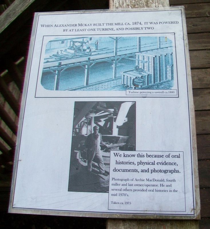
| 4 ► Nova Scotia, Colchester County, Balmoral Mills — Turbines: From Direct to Indirect Power Production — |
| 5 ► Nova Scotia, Colchester County, The Falls — St. Andrew's Presbyterian Church — The Falls, Nova Scotia — 1872 - 2002 — |
| On Nova Scotia Route 311 at Balmoral Road (Nova Scotia Route 256), on the left when traveling north on Provincial Route 311. | |||
| 6 ► Nova Scotia, Cumberland County, Fort Lawrence — Early Inhabitants — |
| 7 ► Nova Scotia, Cumberland County, Pugwash — Evolution of Pugwash Industry — Our Harbour • Our Heritage — |
| On Durham Street at Water Street, on the left when traveling west on Durham Street. | |||
| 8 ► Nova Scotia, Cumberland County, Pugwash — Nova Scotia Clayworks — Our Harbour • Our Heritage — |
| On Water Street at Victoria Street, on the left when traveling north on Water Street. | |||
| 9 ► Nova Scotia, Cumberland County, Pugwash — Pugwash Railway Station — Our Harbour • Our Heritage — |
| On Durham Street (Nova Scotia Route 6) just west of Russell Street, on the left when traveling west. | |||
| 10 ► Nova Scotia, Cumberland County, Pugwash — Pugwash Streetscapes — Our Harbour • Our Heritage — |
| On Water Street just north of Victoria Street, on the right when traveling north. | |||
| 11 ► Nova Scotia, Cumberland County, Pugwash — Pugwash Train Station 1961 — Pugwash Heritage — |
| On Durham Street (Nova Scotia Route 6) just west of Russell Street, on the left when traveling west. | |||
| 12 ► Nova Scotia, Cumberland County, Pugwash — World Wars Memorial — 1914 - 1918 • 1939 - 1945 — Lest We Forget — |
| On Water Street at Durham Street, on the right when traveling north on Water Street. | |||
| 13 ► Nova Scotia, Guysborough County, Larrys River — 4 — Acadian Dyke Building Along the Bay of Fundy — Construction de digues le long de la Baie de Fundy — |
| On Marine Drive (Nova Scotia Route 316) at Ballfield Loop, on the right when traveling west on Marine Drive. | |||
| 14 ► Nova Scotia, Guysborough County, Whitehead — The Canal — |
| On Whitehead Road, on the left when traveling south. | |||
| 15 ► Nova Scotia, Halifax Region, Dartmouth — Starboard Propeller of CCGS John A. Macdonald — |
| 16 ► Nova Scotia, Halifax Region, Dartmouth — Sullivan's Pond — A Marker of Distinction — |
| On Crichton Avenue, 0.1 kilometers Ochterloney Street (Nova Scotia Route 322), on the right when traveling north. | |||
| 17 ► Nova Scotia, Halifax Region, Dartmouth — Totem Pole — |
| On Crichton Avenue, 0.1 kilometers north of Ochterloney Street (Nova Scotia Route 322), on the right when traveling north. | |||
| 18 ► Nova Scotia, Halifax Region, Dartmouth — Vera B. Stone — A Tribute / Un Hommage — |
| 19 ► Nova Scotia, Halifax Region, Halifax — Boer War Memorial Fountain — |
| 20 ► Nova Scotia, Halifax Region, Halifax — Celtic Cross — |
| On George Street at Upper/Lower Water Street, on the right when traveling east on George Street. | |||
| 21 ► Nova Scotia, Halifax Region, Halifax — Drinking Fountain / Fontaine d'eau potable — |
| 22 ► Nova Scotia, Halifax Region, Halifax — Halifax City Hall / Hôtel de ville d'Halifax — |
| Near Argyle Street just south of Duke Street, on the left when traveling south. | |||
| 23 ► Nova Scotia, Halifax Region, Halifax — HMCS Sackville K-181 — Canadian Naval Memorial Trust — "A National Historic Site Of Canada" — |
| 24 ► Nova Scotia, Halifax Region, Halifax — Horticulture Hall, post-1945 — Maison de l'horticulture, après 1945 — |
| 25 ► Nova Scotia, Halifax Region, Halifax — Ocean Terminals/le terminal ocean terminals — |
| Near Marginal Road. | |||
| 26 ► Nova Scotia, Halifax Region, Halifax — Public Garden Foundation Fountain — |
| On Spring Garden Road just west of South Park Street, on the right when traveling west. | |||
| 27 ► Nova Scotia, Halifax Region, Halifax — Summer House / Pavillon d'été — |
| 28 ► Nova Scotia, Halifax Region, Halifax — The Dockyard Clock / L'horloge de L'arsenal — |
| On George Street at the Waterfront, in the median on George Street. | |||
| 29 ► Nova Scotia, Halifax Region, Halifax — Unveiling, Jubilee Fountain / Inauguration, Fontaine du Jubilé — |
| 30 ► Nova Scotia, Halifax Region, Peggy's Cove — A Monumental Work Of Art — |
| On Peggy's Point Road, 0.4 kilometers south of Prospect Road (Nova Scotia Route 333), on the right when traveling south. | |||
| 31 ► Nova Scotia, Halifax Region, Peggy's Cove — Fishermen's Monument — by William E. deGarthe, Artist and Sculptor — |
| On Peggy's Point Road, 0.4 kilometers south of Prospect Road (Nova Scotia Route 333), on the right when traveling south. | |||
| 32 ► Nova Scotia, Halifax Region, Peggy's Cove — Home Sweet Home — |
| On Peggy's Point Road, 0.4 kilometers south of Prospect Road (Nova Scotia Route 333), on the left when traveling south. | |||
| 33 ► Nova Scotia, Halifax Region, Peggy's Cove — The Art of deGarthe — |
| On Peggy's Point Road, 0.4 kilometers south of Prospect Road (Nova Scotia Route 333), on the right when traveling south. | |||
| 34 ► Nova Scotia, Halifax Region, Peggy's Cove — Through Rain, Sleet and Darkest Night — |
| 35 ► Nova Scotia, Inverness County, Chéticamp — La Bouée du havre / The Harbour Bouy — |
| Near Cabot Trail just north of Barren Road, on the left when traveling north. | |||
| 36 ► Nova Scotia, Inverness County, Port Hastings — Construction of the Canso Canal / Construction du Canal de Canso — |
| Near Trans Canada Highway (National Route 104) 0.5 kilometers west of Ceilidh Trail (Route 19), on the right when traveling west. | |||
| 37 ► Nova Scotia, Inverness County, Port Hastings — Operation of the Canso Canal / Exploitation du Canal — |
| Near Trans Canada Highway (National Route 104) 0.5 kilometers west of Ceilidh Trail (Route 19), on the right when traveling west. | |||
| 38 ► Nova Scotia, Inverness County, Port Hastings — The Building of the Canso Causeway / La Construction de la Levée de Canso — |
| Near Trans Canada Highway (National Route 104) 0.5 kilometers west of Ceilidh Trail (Route 19), on the right when traveling west. | |||
| 39 ► Nova Scotia, Kings County, Grand Pré — Grand Pre Marsh Body — 1760-1995 — |
| On Grand Pré Road at Miner Road, on the right when traveling north on Grand Pré Road. | |||
| 40 ► Nova Scotia, Kings County, Grand Pré — Landscape of Grand Pré/ le Payage de Grand Pré — Plan of Horton Town/ Le Plan De Ville de Horton — |
| On King Street at Wharf Road, on the left when traveling east on King Street. | |||
| 41 ► Nova Scotia, Lunenburg County, Bridgewater — 12 — Bridges / Les ponts — ***Riverfront Renaissance*** — |
| On King Street (County Route 331) at the Old Bridge Street bridge over the LaHave River (Nova Scotia Route 3), on the right when traveling north on King Street. | |||
| 42 ► Nova Scotia, Lunenburg County, Bridgewater — 6 — The Great Fire 1899 / Le grand incendie de 1899 — ***Riverfront Renaissance*** — |
| On King Street (Nova Scotia Route 3) at the Old Bridge Street bridge over the LaHave River (Nova Scotia Route 3), on the right when traveling north on King Street. | |||
| 43 ► Nova Scotia, Lunenburg County, Lunenburg — St. John's Anglican Church / Église Anglicane St. John — |
| 44 ► Nova Scotia, Lunenburg County, Lunenburg — St. John's Anglican Church / L'église anglicane St. John's — |
| On Cornwallis Street at Cumberland Street, on the right when traveling north on Cornwallis Street. | |||
| 45 ► Nova Scotia, Lunenburg County, Lunenburg — The Fire / Le Feu — |
| 46 ► Nova Scotia, Lunenburg County, Lunenburg — The Jessen Bell / La Cloche Jessen — |
| On Cornwallis Street at Cumberland Street, on the right when traveling north on Cornwallis Street. | |||
| 47 ► Nova Scotia, Lunenburg County, Lunenburg — Zion Evangelical Lutheran Church / L'eglise lutherienne evangelique de Sion — |
| On Cornwallis Street at Fox Street, on the left when traveling north on Cornwallis Street. | |||
| 48 ► Nova Scotia, Queens County, Liverpool — Beam Trawler Jutland Memorial |
| On Main Street (Nova Scotia Route 3) just east of Legion Street, on the right when traveling east. Reported missing. | |||
| 49 ► Nova Scotia, Queens County, Liverpool — Liverpool Town Hall / L'Hotel de Ville de Liverpool — |
| On Main Street (Nova Scotia Route 3) at Gorham Street, on the right when traveling east on Main Street. | |||
| 50 ► Nova Scotia, Queens County, Liverpool — Remembering the Deceased — |
| 51 ► Nova Scotia, Yarmouth County, Cape Forchu — A Diverse Fishery — |
| 52 ► Nova Scotia, Yarmouth County, Cape Forchu — A Footstep into the Harbour — |
| 53 ► Nova Scotia, Yarmouth County, Cape Forchu — Cape Forchu's Guiding Light — |
| 54 ► Nova Scotia, Yarmouth County, Cape Forchu — In Dire Need of a Lighthouse — |
| 55 ► Nova Scotia, Yarmouth County, Cape Forchu — Phare Cap-Forchu / Cape Forchu Lightstation — |
| 56 ► Nova Scotia, Yarmouth County, Cape Forchu — Pieces of the Past — |
| 57 ► Nova Scotia, Yarmouth County, Cape Forchu — Welcome to the Leif Ericson Trail — |
| 58 ► Nova Scotia, Yarmouth County, Hubbard's Point — Barges de foin salé de Buttes-Amirault — Salt Haystacks of Amirault's Hill — |
| On Nova Scotia Route 308 at Chemin des Gasson, on the right when traveling south on Provincial Route 308. | |||
| 59 ► Nova Scotia, Yarmouth County, Lower West Pubnico — What and When is Le Village Acadien? — Le Village historique acadien, c'est quoi?...c'est quand? — |
| 60 ► Nova Scotia, Yarmouth County, Lower West Pubnico — Les pionniers acadiens / Acadian Pioneers — Le Village historique acadien de la Nouvelle-Écosse — |
| On Old Church Road, 0.7 kilometers east of Nova Scotia Route 335, on the left when traveling east. | |||
| 61 ► Nova Scotia, Yarmouth County, Lower West Pubnico — Recolter la mer / Harvesting the Sea — Quai Dennis Point / Dennis Point Wharf — |
| On Dennis Point Road, 1 kilometer south of D'Entremont Road, on the left when traveling south. | |||
| 62 ► Nova Scotia, Yarmouth County, Tusket — Palais de justice et Prison d’Argyle / Argyle Township Court House and Gaol — |
| On Courthouse Road just east of the Lighthouse Route (Nova Scotia Route 3), on the right when traveling east. | |||
| 63 ► Nova Scotia, Yarmouth County, Tusket — The/Le Village of Tusket — Looking South, ca. 1910 / Regardant Vers le Sud, Environ 1910 — |
| On the Lighthouse Route (Nova Scotia Route 3) at Courthouse Road, on the right when traveling north on the Lighthouse Route. | |||
| 64 ► Nova Scotia, Yarmouth County, Yarmouth — Ballard [sic - Bollard] — |
| Near Water Street. | |||
| 65 ► Nova Scotia, Yarmouth County, Yarmouth — Cape Forchu Lighthouse — |
| On Main Street, on the left when traveling north. | |||
| 66 ► Nova Scotia, Yarmouth County, Yarmouth — Frost Park — |
| On Main Street (Nova Scotia Route 1) just south of Public Street, on the right when traveling south. | |||
| 67 ► Nova Scotia, Yarmouth County, Yarmouth — Frost Park — Town of Yarmouth — |
| On Main Street (Nova Scotia Route 1), on the left when traveling north. | |||
| 68 ► Nova Scotia, Yarmouth County, Yarmouth — M.V. Bluenose Anchor — |
| Near Water Street. | |||
| 69 ► Nova Scotia, Yarmouth County, Yarmouth — Manufacturing — Goods & Services for the Marketplace — |
| On Water Street, 0.1 kilometers south of Richards Lane, on the right when traveling south. | |||
| 70 ► Nova Scotia, Yarmouth County, Yarmouth — Milton Clock — A Symbol of Community Pride & Confidence — |
| On Water Street, on the right when traveling south. | |||
| 71 ► Nova Scotia, Yarmouth County, Yarmouth — Shipbuilding — Building a Connection to the World — |
| On Water Street, on the right when traveling south. | |||
| 72 ► Nova Scotia, Yarmouth County, Yarmouth — Shipbuilding in Nova Scotia / Construction navale en Nouvelle-Écosse — |
| On Main Street at Marshall Lane, on the right when traveling south on Main Street. | |||
| 73 ► Nova Scotia, Yarmouth County, Yarmouth — The Killam Brothers Buildings & Wharf — |
| On Water Street just north of Central Street, on the left when traveling north. | |||
| 74 ► Nova Scotia, Yarmouth County, Yarmouth — the Parker-Eakins Buildings & Wharf — |
| On Water Street at Lovitt Street, on the left when traveling north on Water Street. | |||