The Channel Marker directly across the Channel marks the location of Nevada Point, where the USS NEVADA, the only battleship to get underway on 7 December, 1941, ended her attempted sortie. Believed to be sinking, and thus in danger of blocking the . . . — — Map (db m160703) HM WM
On the mountain slopes in the distance, you can see a series of horizontal lines or terraces etched into the side of the range. These beach lines are left by waves of ancient Lake Lahontan. Over 12,000 years ago, the lake reached a maximum depth of . . . — — Map (db m165833) HM
Lahontan Dam, completed in 1915, is the key feature of the Newlands Irrigation Project which has turned Lahontan Valley into one of Nevada's most productive farming and ranching areas. With completion of the dam's powerhouse, the electrical energy . . . — — Map (db m89515) HM
This portion of the Old Spanish Trail was discovered in January, 1830, by Antonio Armijo during his first trip from Santa Fe to Los Angeles. The spring just north of this marker provided excellent water and fed meadows of luxuriant grass for draft . . . — — Map (db m213760) HM
Originally a Native American trail, Bootleg Canyon – also called the Hooch Highway was a well-known backdoor into Boulder City and the Hoover Dam construction site during prohibition. Bootleggers brewed illegal alcohol in stills hidden in . . . — — Map (db m29324) HM
One of the finest examples of how civil engineering ingenuity shaped the development of society's quality of life in the 20th century. — — Map (db m31900) HM
Born in 1858, Dr. Elwood Mead became a world-renowned water and irrigation engineer. He wrote Wyoming's first water code, the basis for codes throughout the United States, Australia, Canada, South Africa and New Zealand. He wrote the Carey Act, led . . . — — Map (db m31902) HM
Eldorado Canyon runs east from here to the Colorado River and was the site of one of Nevada's mining booms. Prospectors began digging for gold and silver here, about 1859, forming the Colorado Mining District. The three largest mines, the . . . — — Map (db m29328) HM
The building of Hoover Dam was a ray of hope for a nation struggling
with hard times. Newsreel images of the high-scalers who worked the
canyon walls ignited public interest in the project.
"Scaling" is the process of removing loose rock . . . — — Map (db m111191) HM
Since 1935, Hoover Dam and Lake Mead have provided flood control, irrigation, drinking water, and power to communities in the desert. These resources have transformed the southwest into production farmland and thriving communities. The dam was . . . — — Map (db m31879) HM
The Hoover Dam construction crew’s mascot was found as a
puppy by workers at the construction camp. This dog traveled
to and from the dam site with them and spent his days visiting
the many work areas. On February 21, 1941, the life of this . . . — — Map (db m111203) HM
[ Front ]:
"The Old Man"
Francis Trenholm Crowe
Born: October 12, 1882
Died: February 26, 1946
World's Outstanding Builder of Dams
[ Right Side ]:
"We had 5,000 men in a 4000-foot canyon. The problem was to . . . — — Map (db m39485) HM
This cast steel turbine runner (water wheel), which is 14.2 feet in diameter and weighs over 34 tons, powered the N-7 generator at Hoover Dam Power Plant from 1944 to 1982. The function of a turbine runner is to convert the force of falling water, . . . — — Map (db m29248) HM
About two miles in front of you, the remains of the town of Callville lie buried in silt on the bottom of Lake Mead. Originally developed as a port on the Colorado River to supply goods to Mormon settlements, Callville had long been a desolate . . . — — Map (db m3917) HM
The man depicted on this monument is performing one of the most dangerous yet essential jobs in the construction of the (Boulder) Hoover Dam. Sitting in a bosun’s chair, hundreds of feet in the air, his job was to set charges and clear the loose . . . — — Map (db m24317) HM
Commissioner, Bureau of Reclamation, Department of the Interior, 1924-1936 whose life-time work culminated in construction of the Boulder Canyon project creating Lake Mead, named in his honor. — — Map (db m1313) HM
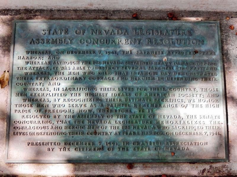
The United States of America will continue to remember that many who toiled here found their final rest while engaged in the building of this dam.
The United States of America will continue to remember the services of all who labored to clothe . . . — — Map (db m1311) HM
During the building of Davis Dam, the Nevada side of the river here became known as Tristate. In 1964, Don Laughlin was looking for an investment opportunity. He had sold his 101 Club in North Las Vegas, and flew over a closed saloon and motel . . . — — Map (db m46732) HM
Virgin Valley was traveled by Jedediah Smith in 1826 and by Fremont in 1844.
The valley served as the right-of-way for the Old Spanish Trail (1829-1848) and for the Mormon road or southern route of travel to southern California.
The areas . . . — — Map (db m1279) HM
Toward the Colorado River from this point runs El Dorado Canyon where occurred one of the biggest mining booms in Nevada history. Gold and Silver mines were developed here about 1859 and soon rich mines were developed. In the 1860's the canyon . . . — — Map (db m29326) HM
Toward the Colorado River from this point runs El Dorado Canyon where occurred one of the biggest mining booms in Nevada history. Gold and Silver mines were developed here about 1859 and soon rich mines were developed. In the 1860's the canyon . . . — — Map (db m29327) HM
Eldorado Canyon, the site of a mining boom, runs east from here to the Colorado River. Prospectors began digging for gold and silver here, about 1859, forming the Colorado Mining District. The three largest mines, the Techatticup, Wall Street, and . . . — — Map (db m92463) HM
On August 30, 1869, Major John Wesley Powell landed at the mouth of the Virgin River, about 12 miles south of here, thus ending the first boat expedition through the Grand Canyon of the Colorado River.
The expedition left Green River City, . . . — — Map (db m46781) HM
Centuries of water runoff from mountain peaks cut channels through Nevada's mountain formations and deserts, creating river corridors that support a variety of wildlife and plants. One such river is the Humboldt, which flows across most of northern . . . — — Map (db m146801) HM
These springs, seen as marshy spots and small ponds of water in the meadows here, are the Humboldt Wells, a historic oasis on the California Emigrant Trail. Here, during the period 1845–1870, hundreds of covered wagons each year rested and . . . — — Map (db m1373) HM
The Humboldt Canal, sometimes termed the Old French Canal, coursed southwestward from Preble, near Golconda, toward Mill City. The present highway crossed it at this point, from whence it ran southerly toward the Humboldt County Courthouse on Bridge . . . — — Map (db m67393) HM
The Humboldt River is the only natural east-west water corridor across the Great Basin. It has been a conduit for travel, trade and communication from prehistoric times to the present. From its headwaters near Wells, Nevada, the river slowly . . . — — Map (db m141454) HM
“The Rolling Stones of Pahranagat,” a hoax article on magnetic currents written in 1862 by Dan deQuille of the Territorial Enterprise, made this valley world famous. Its lakes are filled and its fields are irrigated by three springs, Hiko, Crystal . . . — — Map (db m1290) HM
The legendary Paiute Leader; friend and guide to pioneers; breveted a "Captain" by John C. Fremont; gave his name to a valley, river and town; died near here in 1860.
Dedicated July 20, 1974
By E Clampus Vitus
Julia C. Bulette . . . — — Map (db m30865) HM
The Carson River While camping in 1849, waiting for snow to melt in the Sierra Nevada, frontiersman and wagon train guide Abner Blackburn used a butcher knife to dig Nevada's first-found gold from a creek bed at the mouth of Gold Cañon. The . . . — — Map (db m160800) HM
First settlement in this area was a toll station & bridge constructed on this site in 1859-60 by E.W. Fuller. It was later known as Lake’s Crossing after Myron C. Lake purchased this property in 1863. Lake’s land gift to the new overland railroad . . . — — Map (db m44213) HM
A Missouri mulepacker, William C. Fuller failed to strike it rich in California’s gold fields. His trek home, around 1859 or 1860, included a stop in the marshy valley known as the Truckee Meadows, located north of the Comstock Mining District, . . . — — Map (db m77626) HM
Flowing out of the Sierra Nevada Mountains to the west, the Truckee River is Reno’s most striking natural and historical feature. Shown below on a relief map of the surrounding Reno area are a few of the more significant historical sites near the . . . — — Map (db m44212) HM
In 1859, one of the area's early residents, Charles W. Fuller, built a dwelling on the south side of the Truckee River where the third Riverside Hotel now stands. He constructed a seventeen mile crude sketch of road in the region and received . . . — — Map (db m184325) HM