Dedicated to the
Citizens of Quincy
who made the
supreme sacrifice
in the
Vietnam War
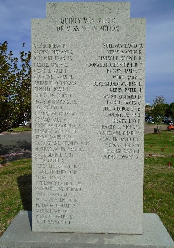
Quincy Men
Killed or Missing in Action
Brian P. Ahern • Richard C. Archer • Francis Builaert
James E. Casale • Ralph Caspole • James H. . . . — — Map (db m119124) WM
To commemorate the
Men and Women of Quincy
who honored her in
World War II
Lest We Forget Our War Dead
These Shall Not Have Died In Vain
[Roll of Honored Dead] — — Map (db m119084) WM
Dedicated to the memory of
the Quincy Boys who offered their
lives during the World War, that
our country and its institutions
might be preserved.
This memorial erected by a grateful city
Quincy, Massachusetts
May 30, . . . — — Map (db m119082) WM
Myles Standish Burying ground is the oldest maintained cemetery in the United States. This sacred ground has been cared for by the town of Duxbury Massachusetts, and takes its name from Myles Standish, military leader of the Plymouth colony who was . . . — — Map (db m56227) HM
Welcome to the Old Burying Ground, c. 1632-1787 The Old Burying Ground (also known as the Myles Standish Burying Ground) is the oldest maintained cemetery in the United States. The first burials occurred here as early as 1632, shortly after . . . — — Map (db m147784) HM
The Old Burying Ground (also known as the Myles Standish Burying Ground) is the oldest maintained cemetery in the United States. The first burials occurred here as early as 1632, shortly after the area began to be permanently settled by Europeans. . . . — — Map (db m160432) HM
Renowned coloratura soprano, noted
both in Europe and America for her
marvelous voice, her wonderful art,
and charming personality.
Passed to spirit life April 3, 1925.
With deepest sorrow we mourn and cry
"Until we meet again" Goodby, . . . — — Map (db m118054) HM
To honor the
Gold Star Mothers of Hull
in memory of their sons
who died in the service
of their country
that liberty might live
World War I
Marie Long • Mary Howard • Esther Mitchell
Mary Shaw • Margaret Canary
World War II . . . — — Map (db m118113) WM
Interred herein are approximately
100 men, women and children
known only to God.
Victims of shipwrecks
on our shores, nearby islands
or shoals, from
1860 to 1898.
Erected in their memory — — Map (db m118049) HM
Erected about 1641, a small building with a thatched roof stood a little north of this enclosure. It was sold in 1657 for 50 shillings when a new church was built near the site of the present First Congregational Church. Here are to be found the . . . — — Map (db m187344) HM
The first English settlers (known as "The Pilgrims") built their first fort/meeting house here. The hill before you has been used for burials by Plymouth residents since the 1620s. Mayflower passengers buried here include Governor William . . . — — Map (db m73160) HM
In memoriam Elder William Brewster Patriarch of the Pilgrims and their ruling elder 1609-1644 Outstanding leader of Pilgrim movement, the founding of Plimouth Plantation and the establishment of civil and religious liberty in the New World. B. at . . . — — Map (db m107522) HM
This monument marks the first burying ground in Plymouth of the passengers of the MayflowerHere, under cover of darkness, the fast dwindling company laid their dead, leveling the earth above them lest the Indians should learn how many were the . . . — — Map (db m107416) HM
Here lies buried ye body of Mr. Thomas Clarke Aged 98. Departed this life March 24, 1697. Thomas Clarke was Mate of the Mayflower according to tradition in the Plymouth and connecting Colonies. History gives his arrival in Plymouth from England in . . . — — Map (db m107462) HM
Fellow-exile with the Pilgrims in Holland, afterwards their chief agent in England. Arrived here IX November, MDCXXI, with Thomas Cushman his son; Preached IX December, his memorable sermon on “The danger of self-love and the sweetness of true . . . — — Map (db m107459) HM
Brass cannon like these were named by Bradford and Winslow in the annals of Plymouth as mounted on the
First Fort, 1621, and were still in use in 1645 when the Ancient And Honorable Artillery Company Of Massachusetts under its commander Major . . . — — Map (db m73187) HM
The burial ground was created with the establishment of the Plympton Green at a town meeting held in Plymouth on March 16, 1702 though it likely did not receive its first burial until around 1706. It was expanded just before 1900 and again around . . . — — Map (db m209128) HM
Front:
“Erected on this Lott
Aug. Ye 2d & 3d dayes, 1636.
Exercised in Novemb. 10 & 11, 1636.”
Top:
To the Memory of
The First
Ministers of Scituate
Giles Saxton — Nathaniel Pitcher
John . . . — — Map (db m30616) HM
Burial place of many of the town’s original settlers who came from Kent County, England, in 1628. This is also the site of the first church in Scituate, built in 1634. — — Map (db m30615) HM
One of America's earliest native born (Boston) composers who greatly enhanced a musical awareness within the Colonies. By respected tradition, his final resting place is believed to be an unmarked grave within this area of the Common. Presented . . . — — Map (db m176196) HM
Established in 1810, this is Charlestown's second oldest burying ground, and the site of the left wing of Colonial forces at the Battle of Bunker Hill in 1775. A monument marks the location of the Rail Fence and Stone Wall fortified by the . . . — — Map (db m55532) HM
This was Charlestown's first cemetery, established about 1630. Local lore has it that the irregular layout corresponded to a map of the town. Many of the stones feature the art of the "Charlestown carver"," an anonymous stonecutter working in the . . . — — Map (db m244543) HM
From 1769-1776 Boston was the flashpoint for events leading up to the American Revolution. On February 22, 1770, a crowd gathered around the house and shop of a Tory sympathizer and customs agent, Ebenezer Richardson. When they started pelting the . . . — — Map (db m18766) HM
Benjamin Franklin was born in Boston in 1707, son of Josiah Franklin (1657-1745), tallow chandler, and his second wife, Abiah (Folger) (1667-1752). After his parent’s deaths, Franklin created a modest memorial to them with an inscription . . . — — Map (db m18780) HM
Within this ground are buried John Hancock, Samuel Adams and Robert Treat Paine, signers of the Declaration of Independence; Governors Richard Bellingham, William Dummer, James Bowdoin, Increase Sumner, James Sullivan and Christopher Gore; Lieut. . . . — — Map (db m18711) HM
In early Boston when someone died, their family or friends indicated their burial site with a marker for remembrance. Often the deceased had already ordered their gravestone before their death. Gravestones were carved by masons, stonecutters, . . . — — Map (db m18783) HM
In the 17th century, religious persecution led to the immigration of large numbers of French Protestants (known as Huguenots) to Massachusetts. Gravestones of the Cazneau, Johonnat, Revere, and Sigourney families can be found throughout . . . — — Map (db m231829) HM
First Master of U.S. Revenue Cutter Massachusetts
The Revenue Cutter Service is the forerunner of the United States Coast Guard. Captain Williams was the commander of the first authorized ship. — — Map (db m215171) HM
Josiah Franklin and Abiah his wife lie here interred. They lived lovingly together in wedlock fifty-five years, and without an estate, or any gainful employment, by constant labor and honest industry, maintained a large family comfortably, and . . . — — Map (db m19280) HM
Here were buried Governors of Massachusetts John Winthrop 1649, John Endicott 1665, John Leverett 1679, William Shirley 1771, Lieut. Governors of Massachusetts William Phillips 1827, Thomas Lindall Winthrop 1841; Governors of . . . — — Map (db m18713) HM
Along the second row parallel to the front path are the stones of the three “Rebeccas”: Rebecca (Baker) Gerrish (d. 1743), Rebecca Smith Sanders (d. 1745/6), and Rebecca (Smith) Alexander Deal Sprague (ca. 1704-1746), who were . . . — — Map (db m18984) HM
This tablet as a memorial to Paul Revere is erected by the Paul Revere Memorial Association to commemorate the opening to the public on April 19, 1908 of his old house at No. 19 North Square in this city. May the youth of today when they visit . . . — — Map (db m18709) HM
When the Puritans landed in Boston in 1630, the Separatist settlement at Plymouth Colony was ten years old. Puritans and Separatists were two Protestant sects that developed in the late 16th century in England. Puritans were critical of, but . . . — — Map (db m19003) HM
Robert Keayne
The founder of the Ancient & Honorable Artillery Company of Massachusetts in 1638 and its first Captain, died 23d March 1655. This stone was the doorstep at his farmhouse Rumney Marsh.
Col. Nicholas Paige
Captain of . . . — — Map (db m215135) HM
Around you are some of the earliest burials at Granary Burial Ground. “The Oldest Stone” dated 1667 marked the burial of John Wakefield (ca. 1615-1667). Apparently a frugal relative 36 years later had the back of the stone carved for Ann Child . . . — — Map (db m191829) HM
Buried in the Winthrop family tomb are 11 members of the Winthrop family. Puritan leader John Winthrop the Elder (1588-1649) was the first governor of the Massachusetts Bay Colony and the founder of Boston. In 1629 he was elected governor by the . . . — — Map (db m18999) HM
Located against the back fence of the burying ground is the Tudor family tomb, marked by a gravestone for John Tudor, Esquire (1709-1795),. The Tudor family legacy began with John Tudor, a baker and deacon of Second Church, who chronicled over . . . — — Map (db m19009) HM
Three hundred years ago this location did not have ideal conditions for a graveyard. There were many underground springs which made it soggy and damp. Tomb owners routinely found their tombs filled with water, with caskets and bodies floating about. . . . — — Map (db m18770) HM
The remains of Samuel Gray Samuel Maverick James Caldwell Crispus Attucks and Patrick Carr Victims of the Boston Massacre, March 5th, 1770, were here interred by order of the Town of Boston. ---------- Here also lies buried the body of . . . — — Map (db m19282) HM
Buried here are many notable people in Boston’s early history, from its first governor, John Winthrop, to Frederic Tudor, the “Ice King.” This is Boston’s oldest burying ground, established in 1630 on what were then the outskirts of the . . . — — Map (db m18979) HM
Patriot, Son of Liberty, and first messenger sent by Warren from Boston to Lexington on the night of April 18-19 1775 to warn Hancock and Adams of the coming of the British troops. Born April 6 1745 Died February 25 1799 Placed by the Massachusetts . . . — — Map (db m18712) HM
Dedicated in sorrow to our grandmother Xiu Ying Gen. She was persecuted by the Communist Party in mainland China from 1949 until she died in 1978 because her husband was a general in the Army of the Republic of China in World War II who moved to . . . — — Map (db m244979)
The first mention of Africans arriving in Boston is in Governor John Winthrop’s diary entry of February 26, 1638, in which he states: “Mr. Peirce, in the Salem Ship, the Desire, returned from the West Indies . . . and brought some . . . — — Map (db m21011) HM
In the 18th century, Copp’s Hill was higher than it stands today. On April 23, 1775, just a few days after the battles of Lexington and Concord, British Admiral Samuel Graves received General Gage’s permission to construct a redoubt on Copp’s Hill . . . — — Map (db m191826) HM
Stroll round among the graves . . . lean on the free stone slab which lies over the bones of the Mathers . . . read the epitaph of stout William Clark, ‘Despiser of Sorry Persons and little Action’ . . . stand by the stone grave of sturdy Daniel . . . — — Map (db m18073) HM
In the 1630s, the northern-most slope of the Shawmut Peninsula (or Boston) was a prominent landmark. Settlers soon discovered its strategic overlook of the Harbor and of the Charles River to the west and found the steep hillock well-protected from . . . — — Map (db m145070) HM
When Copp’s Hill was first established as the “North Burying Ground,” it was just below the summit of one of Boston’s highest hills. Looking north over the colonial wharves one could see the towns of Charlestown and Chelsea and the confluence of the . . . — — Map (db m192057) HM
Most of the gravestones in Copp’s Hill Burying Ground are upright stone markers placed before 1825. The quality and complexity of the carving depended on the skill of the carver and the budget of the person buying the memorial. The majority of the . . . — — Map (db m191735) HM
The Kennebec Raid Captain Thomas Lake (1615-1676) (C-143) was born in Tetney, County Lincoln, England in 1615 and settled in Boston in the 1650s. He and his partner, Thomas Clarke, set up trading posts in Maine, including one at Arrowsic Island . . . — — Map (db m191736) HM
Several generations of great 17th and 18th century New England divines are buried here. Increase (1639-1723), the father; Cotton (1663-1728), the son; and Samuel Mather (1706-1785) the grandson, belonged to a remarkable family of ministers. At a . . . — — Map (db m18976) HM
Throughout Copp's Hill Burying Ground are examples of tombs and monuments constructed to commemorate the dead. Table tombs or table-stones are elaborate markers of a grave's location. Usually there is a sepulcher underneath the marker holding the . . . — — Map (db m145072) HM
Fascinating people from Boston’s history lie in this burying ground. Look to the left for the double Worthylake gravestone, dating from 1718. Worthylake was the first keeper of the Boston Light. He and his wife and daughter drowned as they rowed to . . . — — Map (db m18977) HM
About the Burying Ground Copp’s Hill Burying Ground is the second oldest cemetery in Boston. In 1659, town officials became concerned about overcrowding at the Central Burying Ground (now called King’s Chapel Burying Ground on Tremont Street.) . . . — — Map (db m191817) HM
Roxbury, settled in 1630, is older than Boston. The early town centered around the meetinghouse in Eliot Square, where roads from inland towns merged into the only overland route to Boston.
For two hundred years Roxbury was mainly a rural . . . — — Map (db m214954) HM
This is the birthplace of Lysander Spooner. January 19,1808- May 14, 1887. Champion of Liberty lawyer, abolitionist, entrepreneur, legal theorist and scholar. In this house he wrote "The Unconstitutionality of Slavery" and other works. Spooner died . . . — — Map (db m136396) HM
Who fought in the French-Indian Wars 1755 - 1763 and its Minute Men who responded so quickly to the Lexington Alarm April 19, 1775 and its Revolutionary Soldiers who did their part in winning the war that gave us our freedom and independence 1775 - . . . — — Map (db m63959) HM
First Burial Ground in Millville
is owned by the Chestnut Street Meeting House
Most markers have disappeared through the
ravages of weather and time.
Few names of our first settlers buried here are known,
however, The memory of their . . . — — Map (db m192543) HM
Dedicated in Honor of Southborough's
American Revolutionary War Veterans
1775 - 1783
With Eternal Gratitude to Those Who
Made the Supreme Sacrifice
Major Josiah Fay (d. August 8, 1776)
Private Jesse Amsden (d. March 3, 1778)
Private . . . — — Map (db m122593) WM
This tablet was erected in 1995
in memory of the members of
the early generations of the town
who were buried here
in graves marked and unmarked
between 1727 and 1895 — — Map (db m122594) HM
In memory of
the Revd Nathan Stone,
first Pastor of the Chh. of Christ in
Southborough.
He was born in Harwich Feb. 18, 1708,
graduated at Harvard College 1726.
Ordained to the work of the ministry
in this place Oct. 21, . . . — — Map (db m122595) HM
Built in 1852 on the site of the town's original Meeting House, the Center School helped Sturbridge consolidate its outlying one-room district schools. It continued as a site for elementary education until the 1950s, when the present Burgess . . . — — Map (db m118883) HM
This re-created graveyard reminds us that death is an inevitable part of life. In early New England, most people were buried in graveyards near the meetinghouse, although some were put to rest in family or neighborhood plots. Some graves were . . . — — Map (db m121519) HM
Stone wall built in 1794 by
Revolutionary War Veterans
—————————
Gates a 1920 gift of
Mrs. Joseph Fiske,
granddaughter-in-law of
Josiah Fiske.
Gates restored in 2001 by
the Town . . . — — Map (db m118865) HM
This marks the Northeast Corner of the cemetery which served the Town of Worcester from 1728 to 1824 about 225 graves with their monuments laid flat still remain within this area. — — Map (db m151778) HM
This marks the Southeast Corner of the cemetery which served the Town of Worcester from 1728 to 1824. About 225 graves with their monuments laid flat still remain within this area. — — Map (db m151782) HM
175 entries matched your criteria. Entries 101 through 175 are listed above. ⊲ Previous 100