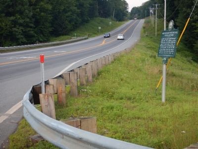
On Franklin Pierce Highway (New Hampshire Route 9) at Pond Brook Road, on the right when traveling west on Franklin Pierce Highway.
In 1772 "the people called Methodist" held their first religious meeting in this state on the James Robertson farm, 1.2 miles north of here, on Christian Street, with Philip Embury as the preacher. On June 20, 1803, Francis Asbury spoke here using . . . — — Map (db m85918) HM
On West Street at St. James Street, on the right when traveling east on West Street.
Civil Rights activist Daniels worshiped at St. James Episcopal Church during his high school years. Born in Keene, he graduated from Virginia Military Institute before entering the Episcopal Theological School in Cambridge, MA. While studying for . . . — — Map (db m85872) HM
On New Hampshire Route 63 at Park Hill Common, on the right when traveling north on State Route 63.
This church, built on the northeast corner of Cole Cemetery in 1762, was moved in sections by ox cart in 1779 to this location, then known as Federal Hill. A steeple with a bell cast by the Paul Revere Foundry was added in 1826. This edifice is . . . — — Map (db m90195) HM
Near Richmond Road (State Highway 119) at Michigan Street, on the right when traveling north.
This church occupies the site of the Town Hall and Meeting House which was destroyed by fire Sept. 12, 1909 after having been the home of the First Universalist Society for more than a century. The present edifice was built in 1912 as a memorial to . . . — — Map (db m154891) HM
On Bridge Street (U.S. 2) at Main Street (U.S. 3), on the right when traveling west on Bridge Street.
This Structure, erected by Major Jonas Wilder, from boards planed and nails wrought on the site, originally possessing a four-fireplace chimney and Indian shutters, is Coos County's first two-storey dwelling. Construction was initiated on the noted . . . — — Map (db m77609) HM
On Main Street, 0.1 miles south of Town Common Road, on the right when traveling south.
The Village of North Stratford occupies the farm of William Fuller, son of Luther Fuller who was killed at Fort Ticonderoga, New York, during the War of 1812. The house of William Fuller was raided by Indians, five hundred of whom camped on the . . . — — Map (db m151897) HM
On Maple Street (New Hampshire Route 142) 0.1 miles north of Main Street (U.S. 302), on the right when traveling north.
Built as a Congregational Church in 1877 by the founding group of eight members, the building became the Maplewood Lodge I.O.O.F. in 1940. It has also served as the Rebekah Lodge.
A beautiful three faced clock kept village residents apprised of . . . — — Map (db m116524) HM
On West Main Street (U.S. 302) at Church Street, on the right when traveling east on West Main Street.
On July 4, 1833, Main Street’s first house of “publick worship” was dedicated here on Meetinghouse Hill.
Several denominations shared the English Gothic church, and it was a famed forum for abolition and temperance causes.
The . . . — — Map (db m116307) HM
On Main Street (New Hampshire Route 302) east of Pleasant Street, on the left when traveling east.
This building was graced with the first church bell and spire in town.
Built in 1850 on the site of the Old Red Store, a pioneer tavern, the church was dedicated on January 8, 1851.
A Greek Revival portico with two fluted Doric columns was . . . — — Map (db m116306) HM
On Main Street (U.S. 302) at Jackson Street, on the right when traveling west on Main Street.
When erected in 1889, this building housed the Littleton Public Library and the Christian Science Society, in which R.D. Rounsevel was prominent.
Its tenants included diverse retailers, insurance offices, the Republic-Journal newspaper, and . . . — — Map (db m116354) HM
On Main Street (New Hampshire Route 3/114) at Church Street, on the right when traveling south on Main Street.
This building was the second Congregational Church to stand on this spot. The first (pictured) had been constructed in 1816 but was sold and moved to Nashua in 1845. Later that same year, this second church was built to accommodate the growing . . . — — Map (db m230496) HM
On Center Street east of Henry Bridge Road, on the left when traveling east.
Built in 1889, the Grasmere Town Hall was
designed by noted Manchester architect
William W. Ireland, who created it in the
Queen Anne style popular at the time.
It was built not only as a meeting hall but
also a school (Schoolhouse #9). For . . . — — Map (db m162622) HM
On Shaker Road, on the right when traveling south.
The unusual name of the former Union church that stood nearby from 1839-1958 came from its elaborate interior that was embellished with scripture, homilies and other decorations made from found materials like cotton gauze, paper and worsted wool. . . . — — Map (db m235443) HM
On Pleasant Street / Franklin Pierce Highway (U.S. 202) at Rum Hill Road on Pleasant Street / Franklin Pierce Highway.
While living at her "Pleasant View" home (1892 - 1908) once on this site, Mrs. Eddy founded The First Church of Christ, Scientist in Boston, Mass., headquarters of the Christian Science movement. From "Pleasant View" some six miles from her . . . — — Map (db m77803) HM
On East Side Drive (New Hampshire Route 132), on the right when traveling south.
On the interval below this spot a committee of the General Court of Massachusetts Bay, their surveyors and attendants there present to locate and survey the Plantation of Penny Cook, conducted the first religious service ever held in the central . . . — — Map (db m129757) HM
On Rocky Pond Road (New Hampshire Route 106) at Shaker Road, on the right when traveling north on Rocky Pond Road.
Take opposite road 2.6 miles to the attractive buildings of this Utopian community organized in 1792 in the township of Canterbury. The Shakers established high standards of agricultural efficiency, craftsmanship and domestic skill for their sect . . . — — Map (db m117623) HM
On New Hampshire Route 103 at NH 103A (New Hampshire Route 103A), on the right when traveling north on State Route 103.
Built in 1832, the Center Meeting House appears to be inspired by Asher Benjamin’s designs for Federal period religious buildings. Construction was financed by the First Toleration Society who wanted a place where all denominations could meet. The . . . — — Map (db m104567) HM
On Pembroke Street (U.S. 3), on the right when traveling south.
This is the site of the first meeting house in
Suncook, incorporated as Pembroke in 1759.
Granted to soldiers in Lovewell's Indian War
(1722-25) or their survivors, the land was
largely settled by Congregationalists from
Massachusetts Bay. . . . — — Map (db m131384) HM
On Chester Street (New Hampshire Route 121) at Raymond Road (New Hampshire Route 102), on the left when traveling east on Chester Street.
The Chester Congregational Church
Built in 1773
Entered in the National
Register of Historic Places
Washington, D.C.
June 5, 1986 — — Map (db m159916) HM
On Meeting House Hill Road, 0.8 miles east of North Road (New Hampshire Route 107), on the right when traveling east.
1772
To Commemorate
the site of
The First Congregational Church
Doorstep in in gateway, location identical.
Ministers and term of service
1772 – Rev. Timothy Upham – 1811
1812 – Rev. Nathaniel Wells – . . . — — Map (db m115950) HM
On Main Street (New Hampshire Route 107) 0.2 miles north of Scribner Road, on the right when traveling north.
Built in 1800, this steepleless structure, originally unheated, was used for both town and church meetings.
This and a similar building in Rockingham, Vt., are the only two survivors of some 70 meeting houses with twin end "porches" . . . — — Map (db m115798) HM
On Landing Road at Park Avenue, on the left when traveling east on Landing Road.
A Little Band of Pioneers
Under the Leadership of
Rev. Stephen Bachiler
of Southampton, England
Seeking a Larger Liberty
In October 1638
Settled in the Wilderness
Near This Spot to Plant a Free Church
In a Free Town
They . . . — — Map (db m162682) HM
Bell of Fifth Congregational Church Building 1797-1844 "Townsfolk to the Church I called."
Bell Inscription: Meneely's West Troy NY 1861 — — Map (db m155072) HM
On this site were leased lots provided by the North Church Parish dating from 1709. One such parcel was the home of Hunking Wentworth, Chairman of the Committee of Public Safety and zealous patriot on behalf of the American Revolution. The site was . . . — — Map (db m76460) HM
On State Street (U.S. 1) at Court Place, on the right when traveling north on State Street.
In 1717 Portsmouth's first identified black family was baptised by South Church.
Baptisms of enslaved people became more frequent in local churches; black marriages, however, were not included in town records until the Revolutionary Era, when . . . — — Map (db m115979) HM
On Congress St (U.S. 1) close to Church Street, on the left when traveling west.
Until the mid 1800's, most New England churches assigned pews to parishioners by their social rank. Black people, enslaved or free, usually were seated as far as possible from the pulpit.
Negro pews in the North Meetinghouse, which stood here from . . . — — Map (db m115983) HM
On Pearl Street at Hanover Street, on the right on Pearl Street.
In 1915 the congregation of the People's Baptist Church which had been meeting in the South Ward Hall for more than twenty-five years, brought this 1857 building for $1200. Though officially Baptist, its membership was multidenominational. For . . . — — Map (db m115984) HM
On State Street at Penhallow Street on State Street.
First Permanent Jewish House of Worship in New Hampshire Star of David New Hampshire's Jewish community dates back to the pre colonial ear. Temple Israel, established as a formally organized community in 1910, affirmed the American principles . . . — — Map (db m76462) HM
This Greek Revival-style church was dedicated on February 15, 1826. Its architect and construction supervisor was Jonathon Folsom, a master builder. The exterior granite was quarried in Rockport, Massachusetts, transported to Portsmouth by water, . . . — — Map (db m96778) HM
On Franklin Pierce Highway (New Hampshire Route 9) 0.1 miles east of Oak Hill Road, on the right when traveling east.
The reinterred graves of two members of the Balch Household are in Pine Grove Cemetery. Rev. Benjamin Balch (1743-1815) was the first chaplain of the Continental Navy and earned the title of “Fighting Parson,” then served as the pastor of the local . . . — — Map (db m235105) HM
On Central Avenue (New Hampshire Route 9) at Washington Street (New Hampshire Route 108), on the right when traveling south on Central Avenue.
Central (Lower) Square, just after the turn of the 20th century, shows the bustling business activity at the intersection of Central Avenue and Washington Street. On the right is the Masonic Temple housing, among many other businesses, Frank J. . . . — — Map (db m152208) HM
Noted preacher, educator, naturalist and historian. Born Boston, Mass. Harvard College 1762. School teacher at Portsmouth and Greenland. Pastor of First Congregational Church at nearby Dover, 1766-1786. Published first History of New Hampshire. . . . — — Map (db m224729) HM
On Chapel Street (New Hampshire Route 4) just east of Saint John Street (New Hampshire Route 4), on the left when traveling east.
St. John's Methodist Church, now St. John's Senior Housing, was built in 1875 for $40,000. Methodism is the third oldest religious denomination in Dover (after the Congregationalists and the Quakers) and their worship services began in 1819 at . . . — — Map (db m152217) HM
On New Hampshire Route 11, on the right when traveling north.
The New Durham Meetinghouse was built by settlers from Durham and nearby towns in 1770 as their house of worship and seat of government until 1819 when the town's first church was built. This area was the town center until the 1850's when the . . . — — Map (db m96748) HM
On New Hampshire Route 12 at Plains Road on State Route 12.
Southerly on Old Church Road is located the first Roman Catholic edifice in New Hampshire. It was erected in 1823 under the direction of the Reverend Virgil Horace Barber, S.J. The building serves St. Mary's parish and contained the first Roman . . . — — Map (db m109414) HM
On Jarvis Hill Road (New Hampshire Route 12A) at Half Mile Road, on the right when traveling south on Jarvis Hill Road.
Located easterly on Old Church Road, this wood-frame structure, built 1771–1773, is the oldest standing Episcopal church in the State, serving the second oldest parish. The parish began in 1768 as a mission of the Society for the Propagation . . . — — Map (db m109370) HM
On New Hampshire Route 10 at 2nd New Hampshire Turnpike/Lempster Mountain Road, on the right when traveling south on State Route 10.
Born at Lempster, N.H., Aug. 17, 1814
Died at Boston, Mass., June 14, 1895
Minister in Boston 47 years
President of Tufts College 13 years
Overseer of Harvard College
Patron of Art • Leader in all reforms
This tablet is . . . — — Map (db m230359) HM
On South Main Street (New Hampshire Route 31), on the right when traveling north.
In April 1842, a group of citizens in this town banded together to form "the first Christian Society." In the Adventist movement of 1842-43, they espoused the Advent hope. In January 1842, these Washington Sabbathkeepers, after meeting for many . . . — — Map (db m73224) HM
On Main Street at Lempster Mountain Road, on the left when traveling north on Main Street.
In 1776 Washington, New Hampshire, became the first town in the nation to be incorporated under the name of General Washington.
In the early 19th century two major turnpikes joined near the site of this wayside park: Second New Hampshire . . . — — Map (db m230400) HM