Near Provincial Road 329, 0.2 kilometers north of Backman Road, on the left when traveling north.
English text only shown
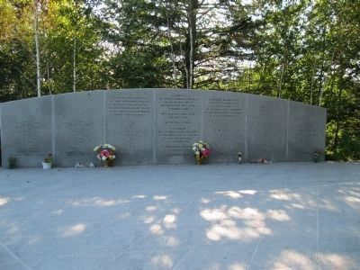
The communities of Peggys Cove and Blandford were central to the recovery operation following the crash of Swissair Flight 111. The Whalesback and Bayswater Beach sites were chosen for their proximity to those . . . — — Map (db m47255) HM
On King Street (County Route 331) at the Old Bridge Street bridge over the LaHave River (Nova Scotia Route 3), on the right when traveling north on King Street.
Bridging the LaHave
It is only fitting that a place named "Bridgewater" should have such a rich history of bridges. Between 1825 and 1983, five bridges have spanned the LaHave River, connecting east and west Bridgewater. Prior to . . . — — Map (db m112428) HM
On King Street (Nova Scotia Route 3) at the Old Bridge Street bridge over the LaHave River (Nova Scotia Route 3), on the right when traveling north on King Street.
Up in Flames
In the cold, early hours of January 12, 1899, a fire began in the basement store of E. B. Simonson, located in the Music Hall at the corner of Dominion Street, and Commercial (now King) Street, where you are . . . — — Map (db m112426) HM
On Bluenose Drive close to King Street, on the right when traveling west.
English
Seafaring of all kinds, and fishing especially, is one of most dangerous occupations. Lunenburgers have lived with the dangers associated with making a living from the sea. Fishermen in dories would get lost in the fog, unable to . . . — — Map (db m78204) HM
On Cornwallis Street at Cumberland Street, on the right when traveling north on Cornwallis Street.
Here, in the year 1753, before any church was built, open-air Divine Services were held and Holy Communion administered in English, French, and German, to the first settlers and Garrison of the Town of Lunenburg by the Reverend Jean Baptiste . . . — — Map (db m112431) HM
On Blockhouse Hill Road at Townsend Street, on the left when traveling north on Blockhouse Hill Road.
English
When the British settlement at Lunenburg was established in 1753, the Town plot was enclosed by pickets surrounding the east, north and west ends of the Town. The west end was fortified by four blockhouses placed at strategic . . . — — Map (db m78328) HM
English
The earliest inhabitants of these lands were the Mi’kmaq. Their nation included most of the territory that later became Acadia and possibly parts of Newfoundland. This area was called Mi’kma’ki. It consisted of seven regions, each . . . — — Map (db m78297) HM
English
In 1750, British authorities, mistrustful of the colony’s large Acadian population, began encouraging immigration by settlers of more obvious loyalties. These settlers became known as the “Foreign Protestants.” They . . . — — Map (db m78296) HM
On Blockhouse Hill Road at Townsend Street, on the left when traveling north on Blockhouse Hill Road.
English
On June 8, 1753, a small flotilla of ships carried 1453 settlers protected by 150 troops and militia, arrived at the harbour which the Mi’kmaq called Merligueche after the whitecaps that topped the waves in the harbour. This group . . . — — Map (db m78318) HM
On Cornwallis Street at Townsend Street, on the right when traveling north on Cornwallis Street.
Solomon House c.1775
One of Lunenburg's Most Historic Homes
Built by Heinrich Koch
Heinrich Koch was nineteen when he arrived
at Lunenburg with the first settlers in 1753.
The next year, with his father Anton, he set
up the town's . . . — — Map (db m112430) HM
English
On March 26, 1921, Smith & Rhuland’s launched hull number 121, the fishing schooner Bluenose. Built from a design by William J. Roué, Bluenose at 258 tons, was the largest schooner ever launched at Lunenburg. Although . . . — — Map (db m78158) HM
On Bluenose Drive close to King Street, on the right when traveling west.
English
By 1870, Lunenburg schooners abandoned the Labrador fishery and concentrated on the fishing banks off of Nova Scotia and Newfoundland. Instead of handlining from the schooner’s deck, fishermen set out in dories - double-ended, flat . . . — — Map (db m78207) HM
On Bluenose Drive close to King Street, on the right when traveling west.
English
Although efforts were made to use large vessels known as otter trawls in the offshore fishery in the 1920’s, they were not used extensively until after the Second World War. Unlike the long line which used baited hooks to attract . . . — — Map (db m78206) HM
On Bluenose Drive close to Cornwallis Street, on the right when traveling west.
English
Lunenburg’s early settlers, the “Foreign Protestants,” came from a rich agricultural area in Europe and it was planned that they should establish farms which could supply both their own needs and those of the colony’s . . . — — Map (db m78259) HM
On Bluenose Drive close to Hopson Street, on the right when traveling east.
English
Lunenburg’s success in the fishery stimulated the construction of many fishing vessels. Almost all of the schooners fishing out of Lunenburg during the Town’s first 200 years were built in the Town or in other Lunenburg County . . . — — Map (db m78154) HM
On Linden Avenue at Bluenose Drive, on the left when traveling west on Linden Avenue.
English
This site known as the Old French Cemetery, is one of the few links to the Town’s Mi’kmaq and Acadian past. Known by the Mi’kmaq as Merligueche meaning whitecaps which topped the waves in the harbour, the name continued to be used . . . — — Map (db m78260) HM
On Bluenose Drive close to Duke Street (pedestrian walkway), on the right when traveling west.
English
A remarkable historical community is found in the streets, public spaces, buildings and daily life of Old Town Lunenburg. Set on a hill overlooking the harbour, Lunenburg was founded in 1753. Its gridiron layout, with a parade . . . — — Map (db m78209) HM
On Rum Row at Bluenose Drive, on the right when traveling south on Rum Row.
English
From 1920 until 1933, the sale of alcohol was prohibited due to the strong “Temperance Movement” in the United States. This prompted a demand for smuggled liquor which proved to be a lucrative business for organized crime . . . — — Map (db m78303) HM
Prominently sited on the parade square, this church was an important symbol of British authority and Anglican dominance for Lunenburg's early settlers, who were mainly German-speaking Protestants. From construction in 1754 through many alterations . . . — — Map (db m112453) HM
On Cornwallis Street at Cumberland Street, on the right when traveling north on Cornwallis Street.
The first Anglican services in Lunenburg were held outdoors on this site and were conducted by a missionary from England. A two-storey structure in the New England Meeting House style was built between 1754 and 1763. The oak frames were . . . — — Map (db m112486) HM
English
More than a century before the founding of Lunenburg, these lands were inhabited by French-speaking settlers, known as Acadians. Their settlements, including one at Lunenburg, then known by its Mi’kimaq name, Merligueche, began in . . . — — Map (db m78294) HM
Beginning in the early hours of November 1, 2001, fire ravaged this historic church, substantially destroying the building. Undaunted by the destruction, the parishioners decided to restore the church. With financial help from friends around the . . . — — Map (db m112454) HM
On Cornwallis Street at Cumberland Street, on the right when traveling north on Cornwallis Street.
This bell hung in the tower of St. John's since 1814 and served as the tolling bell for over 185 years. It was cast at the Whitechapel Foundry in London, England. On November 1, 2001, fire ravished through the Church, destroying the tower and . . . — — Map (db m112432) HM
On Bluenose Drive close to King Street, on the right when traveling west.
The Labrador whaler Anderson Bros. is the type of boat that was used extensively in the Labrador fishery of the 19th century. Lunenburg County had a large fleet of 40 to 60 ton schooners known as “Labradormen” that went to the . . . — — Map (db m78205) HM
On Blockhouse Hill Road at Townsend Street, on the left when traveling north on Blockhouse Hill Road.
English
During the American Revolution many coastal settlements were harassed by enemy privateers. On the morning of 1 July 1782 approximately 100 raiders surprised and overpowered Lunenburg’s small defence force, captured the blockhouses . . . — — Map (db m78317) HM
On Cornwallis Street at Fox Street, on the left when traveling north on Cornwallis Street.
Lunenburg is home to the oldest worshiping Lutheran congregation in Canada. The first Lutherans, mostly Germans from farming districts of the Upper Rhine, settled in the Town in 1753. Initially they worshiped outdoors and later were allowed to . . . — — Map (db m112480) HM
On Main Street (Nova Scotia Route 3) at Edgewater Street (Nova Scotia Route 3), in the median on Main Street.
This stone of remembrance
is erected in loving memory
of our brave men
who laid down their lives
in the Great War
1914 - 1918
for
Truth Justice Liberty
In honour
of all who served
and in grateful appreciation
of the valiant . . . — — Map (db m112530) WM