On Alleghenyville Road (Pennsylvania Route 568) at Kurtz Mill Rd ( Route 568), on the right when traveling east on Alleghenyville Road.
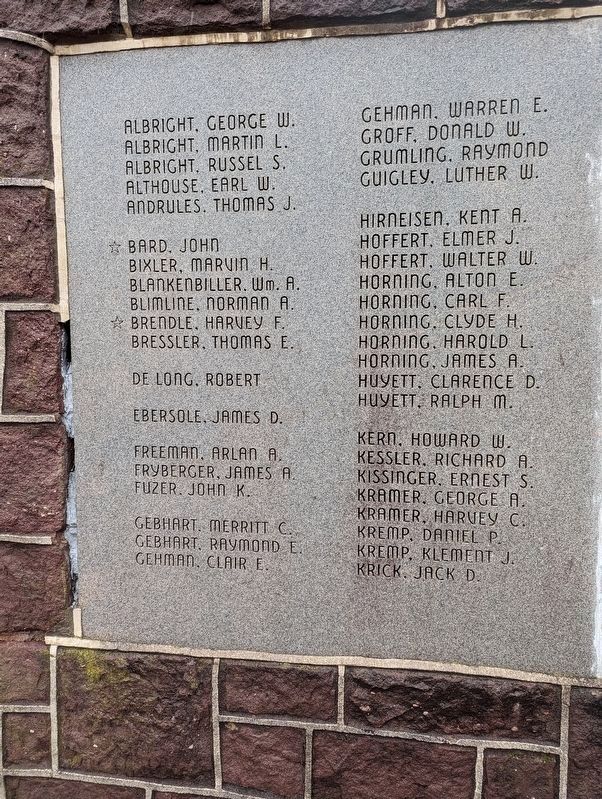
Dedicated to the patriotic men of Brecknock Township who served their Country in World War II 1941-1945
Albright, George W.
• Albright, Martin L.
• Albright, Russel S.
• Althouse, Earl W.
• . . . — — Map (db m244234) WM
On Main St. (PA 100) at 7th Street on Main St. (PA 100).
Re-named Bally for Father Augustin Bally. The third Roman Catholic mission and first Catholic school in the State were established here in 1743 by Father Theodore Schneider — — Map (db m84570) HM
On Christmas Village Road (Pennsylvania Route 4010) at Groff Road on Christmas Village Road.
Organized 1729, this is one of the early Lutheran churches founded by Rev. John Caspar Stoever, Jr., who started the parish records in 1730. A log church, erected before 1749, was replaced by the present stone building in 1809. Since 1853, Lutheran . . . — — Map (db m84515) HM
On Lancaster Avenue (Pennsylvania Route 501) at Fort Henry Road (Local Road 956), on the left when traveling north on Lancaster Avenue.
Built 1756; garrisoned during the French and Indian War by troops under Capt. Christian Busse. Pennsylvania's major frontier defense east of Ft. Augusta (Sunbury). The site is 3/4 mile to the northwest. — — Map (db m29547) HM
On Lancaster Avenue (Pennsylvania Route 501) at Pilger Ruh Road, on the right when traveling north on Lancaster Avenue.
"Pilgrim's Rest" was the name given to this spring on the Tulpehocken Path by Count Zinzendorf, the Moravian missionary, on his journey to the Indian towns of Shamokin and Wyoming in 1742. — — Map (db m29551) HM
Near Lancaster Avenue (Pennsylvania Route 501) at Pilger Ruh Road.
1742
Pilger Ruh (Pilgram's Rest)
Named by Count
Nicholas Ludwig von Zinzendorf
who with Conrad Weiser and
Moravian Missionaries rested here
besides this spring (Ludwig's Brunne)
on their way to visit Shawnee Indians
in Wyoming . . . — — Map (db m158052) HM
On Lancaster Avenue (Pennsylvania Route 501) at Schubert Road, on the right when traveling north on Lancaster Avenue.
Fort Henry, built 1756 to guard Lebanon Valley from Delaware and Shawnee raids, stood 3/4 mile northwest of here on the Tulpehocken Path. The trail came over the mt. near where present road cutting is seen. Round Head overlooks it from east. — — Map (db m29542) HM
On Lancaster Avenue (Pennsylvania Route 501) near Schubert Road.
An Indian path connecting the Iroquois capital at Shamokin, now Sunbury, with the Tulpehocken Valley, ran northwest through here. It was used by ambassadors to "Brother Onas," i.e., Wm. Penn and his successors. — — Map (db m85726) HM
On East Main Street (Pennsylvania Route 345/724) just east of North Mill Street, on the left when traveling east.
William Bird c 1706-1761
In 1751, William Bird, pioneer ironmaster, built the stone mansion which now houses the Birdsboro Community Memorial Center. The home which faced the Schuylkill River, was conveniently situated across . . . — — Map (db m160550) HM
On Schuylkill River Trail 0.2 miles east of Armorcast Road, on the left when traveling east.
Why steel in Birdsboro?
Edward and George Brooke, descendants of Ironmaster William Bird, established the Birdsboro Iron Foundry Company in 1867. With the advent of steel, the name was changed to Birdsboro Steel Foundry and Machine Company . . . — — Map (db m160549) HM
On East Main Street (Pennsylvania Route 345) just west of North Water Street, on the right when traveling west.
Birdsboro Trailhead
The trailhead here at Birdsboro was developed for use by trail users through the efforts of the Community of Birdsboro and Schuylkill River Heritage Area. The trailhead provides visitors with easy access and . . . — — Map (db m160540) HM
On Main Street (Pennsylvania Route 345/724) at Mill Street, on the right when traveling west on Main Street.
Roll of Honor
World War 1917-1918
[Died in service]
Clymer Green J. William Lutz
[Names of others who served follows]
Erected & Dedicated Dec. 13, 1919 — — Map (db m23755) WM
On Water Street at East Main Street ( Route 724/345), on the right when traveling south on Water Street.
By the mid nineteenth century, the industrial iron community of Birds-Borough had developed into an area with distinctly organized neighborhoods. Each had its own pride and identity, each its own ethnic character, and each its own special title. . . . — — Map (db m158350) HM
On Main Street (Pennsylvania Route 345) at School Street, on the right when traveling west on Main Street.
To commemorate the patriotism and perpetuate
the names of those who served with honor
in World War II
[Died in service]
Albert Bryan
Lewis Kennedy
Nick Piergrossi
[Honor Roll follows] — — Map (db m23752) WM
On North Mill Street just south of East Main Street ( Route 345/724), on the right when traveling south.
By the early 1870s, the company store at the Bird Mansion outgrew its allotted space. To solve the problem, the Brooke interest, which had taken over the local iron business, authorized the construction of a larger facility on the southwest . . . — — Map (db m160555) HM
On Benjamin Franklin Highway (U.S. 422) 0.2 miles east of Hillview Road, on the right when traveling east.
Famous pioneer and wilderness scout, who lived in this area his first 16 years. Born 3 miles northwest on site of Daniel Boone Homestead, State historical shrine. — — Map (db m25167) HM
On Baumstown Road (U.S. 422), on the right when traveling east.
Greatest American pioneer and wilderness scout. Born Nov. 2, 1734. Spent the first 16 years of his life on the Boone Homestead a few miles north. Now a State historical shrine dedicated to American youth. — — Map (db m23776) HM
On Benjamin Franklin Highway (U.S. 422) at Daniel Boone Road, on the right when traveling west on Benjamin Franklin Highway.
Greatest American pioneer and wilderness scout. Born Nov. 2, 1734. Spent the first 16 years of his life on the Boone Homestead a few miles north. Now a State historical shrine dedicated to American youth. — — Map (db m163362) HM
On East Baumstown Road (U.S. 422) at Center Road ( Route 82/345), on the right when traveling west on East Baumstown Road.
Hopewell Forge, 1744, and Furnace, 1770, were seven miles south. The furnace and the remains of an iron making community of the era are administered by the National Park Service, with recreation areas. — — Map (db m23784) HM
On Benjamin Franklin Highway (U.S. 422) 0.2 miles west of Limekiln Road, on the right when traveling east.
On his first visit to America
1682 - 1684
came farthest north
on Schuylkill River
fifty miles up
from the Falls of Schuylkill
to or near the mouth of Monocacy Creek
three fourth of a mile
south-[direction erased] of this marker . . . — — Map (db m25202) HM
Established here in 1893 by C.A. Mory and Associates, it was among the largest casket manufacturers in the world and earliest traded on the N.Y. and Phila. stock exchanges. The company secured numerous patents for innovative improvements and designs . . . — — Map (db m84547) HM
On South Reading Ave. (PA 562) at West 2nd Street on South Reading Ave. (PA 562).
Aviation pioneer Spaatz was a 1914 graduate of West Point and a pilot in France in World War I. He rose to the rank of brigadier general in 1940 and general in 1945. During World War II he commanded the US 8th Air Force and the US Strategic Air . . . — — Map (db m84545) HM
The evolution of the business located here mirrors America's changing transportation scene. In the factory begun by Mr. Sweinhart in 1872, horse-drawn carriages, farm and delivery vehicles, and sleighs were built. After 1914, bus and truck bodies, . . . — — Map (db m84546) HM
A disastrous fire destroyed the theater that stood at Philadelphia Ave. & Washington St. on Jan. 13, 1908. It claimed 170 Victims, many buried here, due to overcrowding, poorly designed and unmarked exits, and inadequate fire escapes. The tragedy . . . — — Map (db m49338) HM
On South Reading Avenue at Farmington Avenue on South Reading Avenue.
Established on Iron Stone Creek, one half mile to the east, by James Lewis, Anthony Morris, Thomas Potts, and Thomas Rutter. Called after Colebrookdale Furnace in England, it is considered the first blast furnace to be erected in Pennsylvania, c. . . . — — Map (db m84544) HM
Pioneer ironmaster and opponent of slavery who died 1730. Built Pennsylvania's first ironworks nearby, 1716. In ensuing decade he erected Pine Forge and built this mansion; in 19th century it was an Underground Railroad stop. Academy was founded . . . — — Map (db m84540) HM
On Benjamin Franklin Highway (U.S. 422) at Church Lane, on the right when traveling east on Benjamin Franklin Highway.
Polish pioneer, Indian trader, settled along Schuylkill River in this area, 1712. He served the Provincial government as a messenger-interpreter during negotiations with Indian tribes in 1728. He was buried, 1736, in graveyard of St. Gabriel's . . . — — Map (db m25273) HM
In memory of
Anthony Sadowski
Born c.1669 in Poland
Died April 22, 1736
Whether or not he opened an Indian trading post on the shores of Lake Erie, and gave his name to Sandusky, Ohio, here lies the greatest Polish frontiersman of . . . — — Map (db m25276) HM
On Schuylkill River Trail, on the right when traveling west.
The Rise of the Railroads
Established in 1833 as the Philadelphia and Reading Railroad, the Reading finished its initial 94-mile Main Line between the coal fields of Schuylkill County and Philadelphia in 1842. It fueled Philadelphia's . . . — — Map (db m160520) HM
On Old Philadelphia Pike 0.1 miles north of Britton Street, on the right when traveling north.
A Country Manor
George Douglass (1726-1799) was from a prosperous Chester County farm family. After working as a saddler and innkeeper in Reading, he moved to Morlatton by 1762 with his wife, Mary Piersol Douglass (1731-1798). Douglas soon . . . — — Map (db m160505) HM
Near Old Philadelphia Pike 0.1 miles north of Britton Street, on the left when traveling north.
A Humble Dwelling
This modest stone house was built for Michael Fulk (c. 1743 - 1808) around 1783. Unlike the mansion owned by Fulp's wealthier neighbors, such as the Douglass family just up the lane, it offers insight into the lives of the . . . — — Map (db m160527) HM
On Old Philadelphia Pike 0.1 miles north of Britton Street, on the left when traveling north.
Located along a ford on the Schuylkill River, Morlatton Village was established in the 18th century with the arrival of Mouns Jones and his family from modern Philadelphia. Others soon followed, becoming a part of a diverse regional settlement . . . — — Map (db m160513) HM
On Old Philadelphia Pike 0.1 miles north of Britton Street, on the left when traveling north.
Morlatton Village Trailhead
Morlatton Village Trailhead was developed for use by trail users though the efforts of the Schuylkill River Heritage Area and the Historic Preservation Trust of Berks County. The trailhead provides with . . . — — Map (db m160514) HM
Near Old Philadelphia Pike 0.1 miles north of Britton Street, on the left when traveling north.
Oldest Documented House in Berks County
Mans Jonasson (1663-1727) was descended from Swedes who settled in present day Philadelphia, along with the lower Delaware and Schuylkill Rivers, in 1638. Later known as Mouns Jones he was the first . . . — — Map (db m160529) HM
Near Old Philadelphia Pike 0.1 miles north of Britton Street, on the left when traveling north.
An Early Riverside Settlement
The Schuylkill River played an important role in the settlement and growth of Amity and Union Townships. A shallow crossing at this location allowed people and wagons to ford the river and may have been one . . . — — Map (db m160535) HM
Wealthy and influential colonial settlers.
George Douglass built his family mansion here
and also the White Horse Tavern in 1765.
This stage coach stop was of historical
importance during the Revolutionary War.
Douglassville was named . . . — — Map (db m25279) HM
On Old Philadelphia Pike just north of Britton Street, on the left when traveling north.
In 1701 William Penn granted 10,000 acres of land to seventeen colonists of Swedish descent who were living in present day Philadelphia. The village within the Swedes' Tract was called Morlatton and by 1719 the entire tract became Amity Township, . . . — — Map (db m160499) HM
On Old Philadelphia Pike at Britton Street on Old Philadelphia Pike.
A Wayside Inn
The first innkeepers on the White Horse tract were Swedish settler Marcus Huling and his wife, Margareta, a daughter of Mouns and Ingeborg Jones, the area's earliest European settlers. The Hulings' inn was established in the . . . — — Map (db m160503) HM
On Meetinghouse Road at Boone Road on Meetinghouse Road.
Established 1725 as Oley; name changed to Exeter, 1742. Present stone meeting house built 1759 near site of two previous log structures. Buried here are members of the Boone, Ellis, Hughes, Lee, and Lincoln families. Meetings discontinued 1899; . . . — — Map (db m296063) HM
First European settlers in present Berks County on land granted by William Penn, 1704-5. The home of Mounce and Ingeborg Jones, built 1716 and the oldest house in the county, stands at the opposite end of the river bridge. — — Map (db m84538) HM
In 1853, the Hopewell partners built a hot-blast anthracite furnace here. This new furnace did not burn charcoal but used anthracite coal to smelt iron — an attempt to reduce fuel costs and increase iron production.
Hopewell's anthracite . . . — — Map (db m23867) HM
In the mid-1800s, brick ovens or kilns were built here in an attempt to modernize the charcoal-making process. Believed to be economically beneficial, these kilns fired and produced charcoal but proved unsuccessful. Today the only indication of . . . — — Map (db m23868) HM
Throughout surrounding hills are remains of hundreds of pits such as this one in front of you. Workers, or colliers, tended these pits to transform wood into charcoal — a pure carbon fuel.
Colliers ignited stacked wood covered with leaves and . . . — — Map (db m23977) HM
Teamsters drove wagonloads of hot, newly made charcoal to this cooling shed. Paid by the load delivered, workers dumped charcoal here by removing wagon floorboards. Once charcoal cooled, it was moved and piled in the stone storage house in front of . . . — — Map (db m23980) HM
Ahead of you is a large wooden trough called a flume, part of the west headrace. Water from surrounding Hopewell land flowed down this flume and spilled into buckets on the water wheel, providing a reliable source of water to power the blast . . . — — Map (db m24027) HM
An elaborate arrangement of flowers, herbs, and fruits once decorated these terraces. Violets, poppies, roses, daffodils, and hollyhocks were formally arranged in the ironmaster's garden. Rosemary and thyme scented the air as Hopewell's gardener . . . — — Map (db m23988) HM
On North Richmond Street at West Locust Street, on the right when traveling north on North Richmond Street.
Established in 1909 by Harry C. Urich, the firm designed and fabricated custom auto bodies for the finest domestic and foreign automobile manufacturers, notably Cadillac, Duesenberg, Packard, Mercedes-Benz, ALCO, SGV, and Rolls-Royce. It was . . . — — Map (db m191838) HM
Near Furnace Road 0.5 miles east of Morgantown Road ( Route 10), on the right when traveling east.
Blowing Engine House & Hot Blast Area
The mid-19th century style building with its Gothic windows housed a Weimer model 1889 steam engine to help power the Furnace.
This new hot blast method of producing super heated air replaced the giant . . . — — Map (db m158051) HM
Near Furnace Road 0.5 miles east of Morgantown Road ( Route 10), on the right when traveling east.
The Ironmaster's House
Constructed around 1792 [,] the Joanna Furnace Mansion was the home to the ironmaster and his family. Originally, a federal style home, the house was Victorianized in 1877 by the last ironmaster and his wife -- L. Heber . . . — — Map (db m158257) HM
Near Furnace Road 0.5 miles east of Morgantown Road ( Route 10), on the right when traveling east.
The Ore Roaster was added in the Fall of 1888 to help reduce the sulfur content of lower grade ore. This processed ore greatly reduced the smelting time when placed in the Furnace. The end result was a better quality iron.
Charged with . . . — — Map (db m158253) HM
Near Front Street north of State Street (Old U.S. Highway 22), on the left when traveling north.
This is a photo of the canal and tow path approaching Jacob Geiger’s mill. Mr. Geiger’s mill was steam operated and located on Schuylkill Avenue, the street that angles off just below the WWII monument north of State Street. The mill was later . . . — — Map (db m138473) HM
On Front Street north of State Street (Old U.S. Highway 22), on the left when traveling north.
Martin Kaercher Sr. from Germany purchased 250 acres of land called "Hamburg" in 1772. Its natural wonders made it an ideal area for agriculture and farming. Because of this attribute, "milling" is a prevalent theme in the region's history, . . . — — Map (db m138471) HM
On Church Street north of Pine Street, on the right when traveling north.
To the memory of
Martin Kaercher Jr.
Founder of Hamburg
Martin Kaercher Sr., born in Germany in 1718, emigrated to Berks County in 1738. On Dec. 23, 1772 he acquired 'a certain tract of land called Hamburg' embracing 250 acres of . . . — — Map (db m141067) HM
On State Street (Old U.S. Highway 22) west of North 2nd Street, on the right when traveling west.
Chief Master Sergeant Richard L. Etchberger distinguished himself by extraordinary heroism in connection with military operations against an opposing armed force on 11 March 1968. On this date, Sergeant Etchberger was manning a defensive position . . . — — Map (db m138498) HM WM
Near Front Street north of State Street (Old U.S. Highway 22), on the left when traveling north.
Pictured here is the east end of the covered bridge that crossed both the canal and Schuylkill River about one hundred yards north of the present bridge that allows State Street to extend into Tilden Township. In the fall and winter the east and . . . — — Map (db m138474) HM
On Hex Highway (Old Pennsylvania Route 22) 0.5 miles west of Roadside Drive, on the left when traveling east.
The first organized Amish Mennonite congregation in America. Established by 1740. Disbanded following Indian attack, September 29, 1757, in which a Provincial soldier and three members of the Jacob Hochstetler family were killed near this point. — — Map (db m174965) HM
On Chestnut Street (Pennsylvania Route 100) north of Seisholtsville Road (County Road 1010), on the right when traveling south. Reported missing.
Established by Thomas Maybury in 1745 on the west bank of the Perkiomen Creek for the purpose of manufacturing iron. Maybury is credited with producing here in 1767 the first cast-iron cooking-stove in North America. — — Map (db m310578) HM
Born in Reading, this self-taught artist won international recognition for his paintings of barnyard and woodland creatures, still lifes, and landscapes. He was the creator of the famed Bon Ami chick. Ben Austrian had studios in Paris and Florida . . . — — Map (db m85725) HM
On Hawk Mountain Road just north of Route 895, on the left when traveling north.
Founded in 1934 by Rosalie Edge, it is the world's first refuge for birds of prey. It had been a popular shooting site because of its location on a major hawk migration corridor and a 1929 bounty placed on northern goshawks. Through the work of its . . . — — Map (db m140170) HM
Hawk Mountain Sanctuary
Has been designated a
Registered
Natural Landmark
Under the provisions of the
Historic Sites Act of August 21, 1935
This site possesses exceptional value
In illustrating the natural . . . — — Map (db m224225) HM
On New Holland Road (Pennsylvania Route 625) south of Baker Avenue, on the left when traveling south.
Dedicated by the
Grateful citizens of
Kenhorst
In honor of those
Who served in the
Armed Forces of
The United States
In World War Two
1941-1945
These made the
Supreme Sacrifice
Wm. H. Baker Jr.
Edward J. Creek . . . — — Map (db m243256) WM
On New Holland Road (Pennsylvania Route 625) at Fern Avenue, on the right when traveling north on New Holland Road.
★ ★ ★ ★ ★
In memory of
Soldiers and Sailors
St. Mary's R.C. Church
who gave their lives
for their country
1917 ★ 1918
World War I
Frank Godziejewski •
John Cieplinski •
Walter . . . — — Map (db m161107) WM
Brick-end decorated barns are one of the finest classics of rural American architecture. These southern & central Pennsylvania barns were very expensive to build. The brick ends were constructed with designs which were formed by the gaps, or . . . — — Map (db m105321) HM
The most common cider press of the 18th century was the two-screw press. Two men would turn the large wooden screws. As they turned, the roof was lowered onto the apple pulp. As the pressure increased, the cider flowed.
The first step in . . . — — Map (db m105452) HM
The first step in making cider in the days gone by was to grind the apples into pulp, called pomace in English and "dreschter" in the dialect. Then the "dreschter" was imbedded in layers of flailed rye straw. The cider press was operated by two . . . — — Map (db m105315) HM
Although many Pa. Dutch colour their Easter eggs with commercial dyes, some still use the traditional methods. To get the different colours, various vegetables and roots are boiled with the eggs.
Adler [sic - Alder] catkins and hickory . . . — — Map (db m105318) HM
For the Pa. Dutch, the dew which falls from heaven on the anniversary of the coming of the Christ child is supposed to have beneficial effects. Here are several examples: since the number 3 is considered lucky, three pieces of bread are hung on . . . — — Map (db m105511) HM
The Dutch Country, like the rest of singinging [sic] America, has a two-fold folksong tradition: secular & religious. The Pennsylvania Spiritual is an original contribution to American hymns. Of the two folksong traditions the most important in . . . — — Map (db m105455) HM
Raisin pie is still known as leicht (funeral pie). This pie was a favorite at the gathering of family & friends which was held after the funeral services. In fact, raisin pie was rarely served except at these funeral gatherings.
The Big Valley . . . — — Map (db m105454) HM
Literally, in the Pa. Dutch dialect this means Green Thursday. The day is also known as Holy Thursday, or Maunday Thursday. For the Pa. Dutch, the day before Good Friday became known as Green Thursday because you had to eat something green that . . . — — Map (db m105323) HM
On New Year's Day, you must say, "Happy New Year" to the flowers in your garden. If you don't, they will not bloom in the spring.
To insure good luck & health all year, you should eat sauerkraut on New Year's Day.
Note: To this day, roast pork, . . . — — Map (db m105398) HM
During the 18th century, every Pa. Dutch farmscape included an outdoor bake oven. Since Pa. Dutch farm women did not yet have woodstoves, they had to devise a way to bake. Most farm kitchens contained large open-hearth fireplaces, over which . . . — — Map (db m311786) HM
The ballad is a narrative song which deals with murder, suicide, natural calamities, & unrequited love. Although ballads were sung throughout Europe, most American ballads parallel the British Isle's ballads. Pa. Dutch ballads were often of a . . . — — Map (db m105313) HM
Although English villages such as Stratford-on-Avon, are the most famous examples of half-timbering, Pa. also has its share of these structures. There are two styles of Pa. half-timbering. The country-style has plastering between the exposed, . . . — — Map (db m105512) HM
Prospects of marriage: after a quilt was completed at a quilting party, four unmarried girls would each take a corner of the new quilt and hold it so it sagged in the middle. A cat was put into the quilt, and then with a little jolting would run . . . — — Map (db m105356) HM
Prospects of marriage: after a quilt was completed at a quilting party, four unmarried girls would each take a corner of the new quilt and hold it so it sagged in the middle. A cat was put into the quilt, and then with a little jolting would run . . . — — Map (db m105515) HM
New England Puritans celebrated their November Thanksgiving as a substitute for Christmas which was forbidden to them. Pa. Gay Dutch celebrated Christmas & had their own Thanksgiving called Harvest Home.
A cultural conflict resulted when New . . . — — Map (db m105451) HM
Shortly after the American Revolution revivalism struck the American frontier & kindled a new, totally American institution, the camp meeting. Born on the Southern frontier, the camp meeting soon invaded the Pa. Dutch Country where it was known as . . . — — Map (db m105450) HM
"Der licht macher" means light maker or candlemaker, who used beeswax or bayberry wax for his candles. Professional candlemakers were usually found in large towns & cities. The candlemaker hung a wick, with a small weight at the bottom from a piece . . . — — Map (db m105399) HM
In Colonial America, the Dutchman of eastern Pa. grew the nation's wheat & the Scotch-Irishman of western Pa. made the nation's rye whiskey. Both the flour from the wheat & the whiskey were barreled for shipment to eastern seaboard markets. To . . . — — Map (db m105360) HM
The Mennonites were named for Menno Simmons, a 16th century Dutch leader. They are descendants of the 16th century religious radicals who were known as Anabaptists. They wanted to reserve the rite of baptism for those adults who had made a . . . — — Map (db m105513) HM
4121 entries matched your criteria. The first 100 are listed above. Next 100 ⊳