On 9 Avenue Southeast at 6 Street Southeast, on the right when traveling west on 9 Avenue Southeast.
What would you do if you founded a city, and no one remembered where it began? In 1875, the North West Mounted Police (NWMP) established Fort Calgary at the confluence of the Bow and Elbow Rivers, laying the foundation for the city of . . . — — Map (db m221500) HM
Near 9 Avenue Southeast, 0.3 kilometers east of 6 Street Southeast, on the right when traveling east.
The North West and Hudson's Bay fur trading companies sent traders and explorers into unknown territories to find new Aboriginal trading partners. David Thompson, often accompanied by his Métis wife Charlotte Small and their children, travelled . . . — — Map (db m221687) HM
Near 9 Avenue Southeast, 0.3 kilometers east of 6 Street Southeast, on the left when traveling east.
The Real People include the Siksika, Kainai and Piikani tribes of the Blackfoot Nation. The nomadic Nitsitapi who lived in this area hunted the buffalo and gathered the prairie vegetation for food, clothing, shelter, tools, medicines and . . . — — Map (db m221698) HM
Near 9 Avenue Southeast, 0.3 kilometers east of 6 Street Southeast, on the left when traveling east.
The Métis, descendants of European fur traders and Aboriginal women, moved into this area in the late 1800s. They held large organized buffalo hunts to obtain hides and meat that they sold to the Hudson's Bay Company, settlers and Mounted Police. . . . — — Map (db m221699) HM
Near 9 Avenue Southeast, 0.3 kilometers east of 6 Street Southeast, on the left when traveling east.
In 1873, Prime Minister John A. Macdonald passed legislation that created the North West Mounted Police. This Police Force guaranteed Canadian sovereignty and prepared for the settlement of the land. — — Map (db m221750) HM
Near 9 Avenue Southeast, 0.3 kilometers east of 6 Street Southeast, on the left when traveling east.
In 1869, Canada bought Rupert's Land but failed to provide the area with any government presence. The illegal whiskey trade, the need to build a national railway, fear of American settlers laying claim to the land and the massacre of several . . . — — Map (db m221775) HM
Near 9 Avenue Southeast, 0.3 kilometers east of 6 Street Southeast, on the left when traveling east.
Officers led 300 enlisted men, Métis Guides, wagons and carts loaded with supplies, two nine pound field guns, beef cattle and haying equipment out of Dufferin, Manitoba in early July 1874 on their historic trek to the western prairies. By late . . . — — Map (db m221784) HM
Near 9 Avenue Southeast, 0.3 kilometers east of 6 Street Southeast, on the left when traveling east.
F Troop, under the leadership of Inspector Ephrem Brisebois, travelled to the confluence of the Bow and Elbow Rivers to establish an outpost part way between Fort Macleod and Fort Edmonton. The I. G. Baker and Company was hired to supply materials . . . — — Map (db m221791) HM
Near 9 Avenue Southeast, 0.3 kilometers east of 6 Street Southeast, on the left when traveling east.
A promise to connect British Columbia with the eastern provinces forced the government to build a national railroad. The Canadian Pacific Railway located its station west of the Fort in 1883 and sold the surrounding lots to eager Calgarians. The . . . — — Map (db m221799) HM
Near 9 Avenue Southeast, 0.3 kilometers east of 6 Street Southeast, on the left when traveling east.
The old fort was demolished and new log buildings with shingled roofs were constructed. Without the fort the name changed to Calgary Barracks. As headquarters for 'E' Division, Calgary was responsible for all the land north to Red Deer, south to . . . — — Map (db m221800) HM
Near 9 Avenue Southeast, 0.3 kilometers east of 6 Street Southeast, on the left when traveling east.
When he arrived in Calgary to take over as Commanding Officer, Captain Richard Burton Deane refused to live in the dilapidated Officers Quarters that he found at Calgary Barracks. He received permission from Ottawa to construct a new home that was . . . — — Map (db m221801) HM
Near 9 Avenue Southeast, 0.3 kilometers east of 6 Street Southeast, on the left when traveling east.
Calgary began to change from a small community whose economy was based in ranching and agriculture. Entrepreneurs opened businesses like a brewery, sandstone quarries, and a steam tractor dealership. Calgarians enjoyed a zoo, city parks, schools, . . . — — Map (db m221802) HM
Near 9 Avenue Southeast, 0.3 kilometers east of 6 Street Southeast, on the left when traveling east.
One year after the train arrived, Calgary was incorporated as a town and in 1894 it became the first city of the North West Territories. Sandstone buildings replaced wooden stores and homes and Calgary became known as the Sandstone City. — — Map (db m221700) HM
Near 9 Avenue Southeast, 0.3 kilometers east of 6 Street Southeast, on the left when traveling east.
In the first half of the twentieth century, Calgarians struggled through two World Wars and the Great Depression. The construction of the CPR railcar repair shops and creation of the Glenmore Dam on the Elbow River employed many people when jobs . . . — — Map (db m221970) HM
Near 9 Avenue Southeast, 0.3 kilometers east of 6 Street Southeast, on the left when traveling east.
While planning Calgary's 1975 Centennial Celebrations, Alderman John Ayer led a committee of citizens in a successful attempt to recover the City's birthplace — Fort Calgary. The City acquired the land, excavated the archaeological remains of Fort . . . — — Map (db m222014) HM
Near 9 Avenue Southeast, 0.3 kilometers east of 6 Street Southeast, on the left when traveling east.
Names of Calgary streets, parks, buildings and landmarks honour and recall people and places from our fascinating history. George C. King Apartments and Footbridge George C. King was the first NWMP to set foot on the site where Fort Calgary . . . — — Map (db m221648) HM
Near 9 Avenue Southeast, 0.3 kilometers east of 6 Street Southeast, on the left when traveling east.
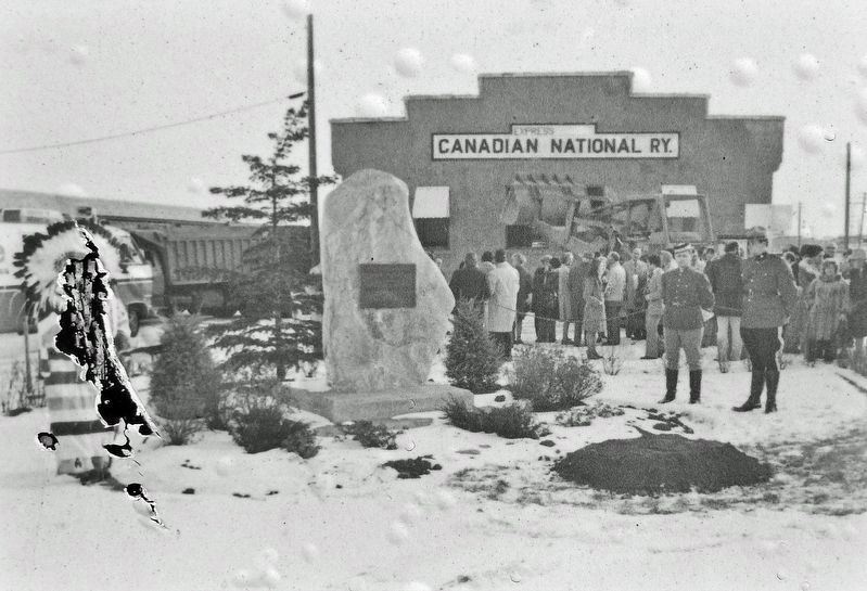
The Fort that would have been a freeway In the late 1960s Fort Calgary was occupied by the Canadian National Railway and a number of businesses, including MacCosham's Van Lines. A 1966 redevelopment plan for downtown called for . . . — — Map (db m222035) HM
Near 9 Avenue Southeast, 0.3 kilometers east of Street Southeast, on the left when traveling east.
A real estate boom from 1907-1913 brought big opportunities for business and transportation. The NWMP Barracks were in a prime location and the Federal Government sold Fort Calgary to the Grand Trunk Pacific Railway. The first tracks were built in . . . — — Map (db m222036) HM
Near 9 Avenue Southeast, 0.3 kilometers east of 6 Street Southeast, on the left when traveling east.
Calgary’s progress from police outpost to modern city has required difficult choices about our vision of success as a community. The development of our city can be traced through what we did with Fort Calgary and our river valleys. The railway . . . — — Map (db m222037) HM