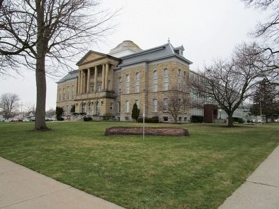
On Hawley Street at Niagara Street, on the left when traveling north on Hawley Street.
Niagara County Courthouse has been placed on the National Register of Historic Places in 1997 by the United States Department of the Interior. — — Map (db m93216) HM
On Prospect Street 0.1 miles south of Old Falls Street, on the left when traveling north.
In memory of all Americans in the armed forces who sacrificed their lives in a time of need to preserve the freedom of this great nation.
The American Legion, Department of New York, Niagara County Committee, October 11, 1986.
Korean . . . — — Map (db m78993) WM
On Park Avenue at Hawley Street, on the right when traveling west on Park Avenue.
The Purple Heart is the oldest military decoration currently used in the world and was the first U.S. decoration to acknowledge the personal suffering of the common soldier. Initially General George Washington established the Purple Heart during . . . — — Map (db m277556) HM
Near Saunders Settlement Road (New York State Route 31) 0.4 miles east of Townline Road ( Route 429), on the left when traveling east.
Honoring All Who Have Served
The Veterans Memorial Park at Niagara County Community College was established on April 28, 1976.
The original park was unveiled to the community in celebration of the Bicentennial anniversary of the . . . — — Map (db m271426) HM
Near Niagara Street 0.1 miles west of Prospect Street.
This dwelling was built by Charles A. and Louise Williams Kandt in 1886 and was occupied by four generations of the Kandt family until 1998 when it was purchased by the Niagara County Historical Society. — — Map (db m81732) HM
It was at this spot on the morning of October 26, 1825, that Governor DeWitt Clinton officially opened the waterway that transformed America. More than eight years had passed since he broke ground on the canal, and after 363 miles, the engineering . . . — — Map (db m84500)
Near Niagara Scenic Parkway (State Road 957A) 0.5 miles east of Buffalo Avenue, on the right when traveling east.
Built by French 1750, 100 ft. westward in Fort Little Niagara's barracks which they burned in 1759. To it British built in 1761, the Stedman House (where that master of the portage lived until U.S. occupation in 1796), which in 1808, became . . . — — Map (db m226684) HM
Near Lundy's Lane at Hanan Avenue, on the right when traveling east.
This Monument erected July 25, 1991
by the American Legion, Niagara
County Committee & Dept. of New York
In memory of the U.S. Officers &
Soldiers who died at the Battle
of Lundy's Lane
Connecticut 25th; New York 23rd;
Massachusetts . . . — — Map (db m49695) HM
On Clinton Street at Washington Street, on the left when traveling east on Clinton Street.
First Court House built 1810. Destroyed at the burning of Buffalo by the British - December 30, 1813.
Second Court House built 1816-17. Abandoned March 11, 1876.
Niagara County formed from Genesee County March 11, 1888 and Erie County from . . . — — Map (db m65922) HM
On Young Street at Main Street, on the right when traveling west on Young Street.
Thanks to the Erie Canal, the Niagara River, a naturally commodious harbor and a growing railroad center, the Tonawandas became a thriving lumber port during the last half of the nineteenth century. Lumber from Minnesota, Wisconsin, Michigan and . . . — — Map (db m166243) HM
In commemoration of the 150th anniversary of the completion of the original locks which opened a connecting waterway between the Hudson River and the Great Lakes. This completion of the Erie Canal was the opening of a door to the settling of the . . . — — Map (db m65659) HM
On West Avenue at Park Avenue, on the left when traveling east on West Avenue.
Welcome to Ida Fritz Park 1908 2001 Historically, Ida Fritz Park is the oldest park in the City of Lockport, created by the NYS Legislature on May 12, 1876. The by-gone fountain was dedicated in 1891. The 7" cannon was presented to Lockport by . . . — — Map (db m93231) HM
On Main Street (New York State Route 104) at Portage Road, on the right when traveling north on Main Street.
Gad Pierce Tavern. Site of 1807 tavern built by Gad Pierce. US Militia delayed a British and Indian attack here on Dec 20, 1813 and escaped thru back door. Tavern rebuilt after war. — — Map (db m70968) HM
On Wilson Burt Road (County Road 52) 0.7 miles west of Maple Road, on the right when traveling west.
Billy Sherman
Confederate horse
captured by
L.N. Pratt, 1st Bugler
Co. M., N.Y. Lt. Arty.
at Battle of Chattanooga
Riden by him in
Sherman's March to the Sea
Died 1887 - 32 yrs. — — Map (db m70060) HM WM
On Market Street at Exchange Street, on the right when traveling west on Market Street.
The New York State Barge Canal System is 524 miles long of which 348 miles is within the Erie Barge Canal. Although water depths vary, the depth of the water in the Lockport section is approximately 8 - 12 feet.
The Lockport Locks Nos. 34 and . . . — — Map (db m74517) HM
On Lake Road (New York State Route 18) 0.2 miles west of Hosmer Road (County Route 65), on the right when traveling west.
The Working Farm. By 1900 mechanization has come to the farm. Equipment was available that made plowing, planting, and harvesting more productive. But, in the days before the gas engine, it was the horse that supplied the power to run the . . . — — Map (db m79540) HM
On Franklin Street at East Main Street, on the right when traveling north on Franklin Street.
Where Families Came to Play Once a prime recreation destination, Olcott Beach drew thousands annually. Trains brought summer vacationers from inland cities. Steamers ferried them between other lake ports. They stayed at grand hotels, played at . . . — — Map (db m73863) HM
On Tonawanda Creek Road at New Road, on the right when traveling west on Tonawanda Creek Road.
During more than 175 years of existence, the Erie Canal has followed more than one path. In some places, two or three generations of Canal infrastructure still exist side by side. When technology, especially mechanized boats, made it possible for . . . — — Map (db m94637) HM
On East Main Street at Longs Avenue, on the right when traveling west on East Main Street.
Welcome to Tonawanda Gateway Harbor - where the Niagara River meets the Erie Canal. Prior to the 1800's this area was a wilderness frequently traversed by Seneca Indians from the Iroquois Confederacy. The first known white settlers were Henry . . . — — Map (db m87802) HM
On East Niagara Street at East Avenue, on the right when traveling west on East Niagara Street.
In 1884, the Tonawanda Gas Light Company was incorporated to supply gas to both Tonawanda and North Tonawanda for street and house lighting. The "gas works" was located on property once owned by Mary Long. Between the Canandaigua and Erie . . . — — Map (db m166212) HM
On Young Street at Main Street, on the left when traveling east on Young Street.
Rise of the Railroad
On August 26, 1836, the first steam locomotive in Western New York made its maiden run between Black Rock and Tonawanda at a speed of 15 - 20 miles an hour. By the 5th of November that same year, regular trips were made . . . — — Map (db m77302) HM
On Glenwood Avenue 0.8 miles west of Gooding Street, on the right when traveling west.
Washington Hunt 1811-1867. Served as U.S. Representative 1843-1849. NY State Comptroller 1849 and NY Governor 1850-1852. Buried here. — — Map (db m165055) HM
War of 1812 Battles Were Fought Upon the Land of This Farm Arriving in 1807, James McClew was among the first handful of non-Native American settlers to come to this area. Only a few pioneers had settled in what is now the Town of Newfane . . . — — Map (db m78683) HM
On North Tonawanda Creek Road at Irish Road, on the right when traveling north on North Tonawanda Creek Road.
At 9:00 am on the twenty-sixth day of October eighteen hundred and twenty-five, the Grand Erie Canal was officially opened. In Buffalo at the foot of Main Street, Governor DeWitt Clinton boarded the packet boat, Seneca Chief, which was elegantly . . . — — Map (db m74004) HM
On Ridge Road (New York State Route 104) 0.2 miles west of Wilson Cambria Road ( Route 425), on the left when traveling west.
Oldest clapboard house in Niagara County. Built by William Howell on 1801 log cabin site of Philip Beach, first settler. First town meeting held here. — — Map (db m81132) HM
On Carmen Road (County Route 121) at Seaman Road, on the right when traveling north on Carmen Road.
Town of Hartland District 10. Built 1845. The earliest cobblestone school in Niagara County. Used for over 100 years. On State and National Register. — — Map (db m78634) HM
On River Road (New York State Route 18F) 0.2 miles north of Riverwalk Drive, on the left when traveling north.
Built 1849 by Reuben H. & Maria Barton Broughton. R.H. Broughton served as state assemblyman - 1837. Town Supervisor - 1856. In 1857, it was purchased by Silas Hopkins, first judge of Niagara County and was named Grand View. Grand View was . . . — — Map (db m82803) HM
On South 9th Street at Center Street ( Route 18F), on the left when traveling north on South 9th Street.
This cornerstone is all that remains of the first New York State chartered school in Niagara County. Students from both sides of the border attended this fine school from 1826 through the 1850's.
This monument placed by the Bicentennial . . . — — Map (db m75650) HM
On South 4th Street 0.1 miles south of Tuscarora Street, on the left when traveling south.
Scovell Knoll is a rocky outcrop formed by an erosion-resistant bedrock cap that protected the area from the leveling effects of the glaciers during the end of the last ice age. The area has hydrologic features associated with fissures in the . . . — — Map (db m82247) HM
On Maple Drive 0.1 miles south of Church Road, on the right when traveling south.
In memory of the men of the Town of Wheatfield who died in the World Wars
1917 * 1918
1941 * 1945
Korean War
1950 * 1953
Vietnam War
1964 * 1973 Wheatfield Veterans Memorial History. In June 2018, a small but determined group of veterans . . . — — Map (db m77390) WM
On South Main Street, on the right when traveling north.
This Log cabin was built by Levi N. Kendalll, born April 19, 1822, rock Port, Niagara County, New York. He was a member of the advance guard of the First Company of Pioneers to enter the Salt Lake Valley, July 24, 1847, where he assisted in the . . . — — Map (db m148665) HM
On Market Street at North Adam Street, on the right when traveling west on Market Street.
Lowertown is in a geographically distinct section of the City of Lockport with such boundaries as the Erie Canal and the Niagara Escarpment.
"A village within a city," Lowertown thrived as Lockport's social, commercial and industrial center . . . — — Map (db m77030) HM
Near Lake Avenue (New York State Route 78) 0.5 miles north of Old Niagara Road.
Throughout the 1970s, the Widmer Wine Company maintained a sign on Lake Avenue, Lockport at the Odd Fellows and Rebecca Home property. This sign gave the history of the Niagara Grape and directed visitors to an old vine on the property which was . . . — — Map (db m187098) HM
On Whirlpool Street (New York State Route 182) at Ontario Street, on the right when traveling south on Whirlpool Street.
Gorge Trail 4·Great Gorge Railway.(1.1mi, 1.8km) The Niagara Gorge Trail System is made up of a series of trail sections located in and along the Niagara River Gorge. Two of these trails are located along the top: the Niagara Gorge Rim Trail . . . — — Map (db m82800) HM
On Center Street (New York State Route 18F) at North 5th Street, on the right when traveling west on Center Street.
Archaeological investigations at the First Niagara Bank at 500 Center Street in Lewiston, New York, yielded abundant information about how people utilized the site during historic and prehistoric times. Prehistoric artifacts recovered from the . . . — — Map (db m82110) HM
On Center Street (New York State Route 18F) at Robert Moses Parkway/NY Route 104 Off Ramp ( Route 104), on the right when traveling west on Center Street.
In 1810, the few settlers of the village under the leadership of pioneers Bates Cooke and Benjamin Barton petitioned the state of New York to have this area changed from a public square to building lots for purposes of selling. Benjamin Barton was . . . — — Map (db m72506) HM
On Ontario Street 0.1 miles west of North Transit Road (Route 78), on the right when traveling west.
Col. W. M. Bond House 1823 has been placed on the National Register of Historic Places by the United States Department of the Interior — — Map (db m79962) HM
On Cold Springs Road 0.1 miles Chestnut Ridge Road ( Route 31), on the right when traveling north.
Cold Springs Cemetery. Jesse Hawley, who first advocated building Erie Canal in 1805, is buried here. Friend of DeWitt Clinton. — — Map (db m267964) HM
On Payne Avenue 0.1 miles south of Thompson Street, on the right when traveling north.
This Cemetery was founded on Feb 12, 1868 as the Col. John Sweeney Rural Cemetery Association. Many graves are from the Tonawanda Burying Grounds formerly located along the Niagara River south of Tonawanda Creek. In 1921, the cemetery was . . . — — Map (db m80189) HM
On Wilson-Tuscarora State Park Road 0.2 miles north of Lake Road ( Route 18), on the left when traveling east.
Wilson-Tuscarora State Park is located in Niagara County along the south shore of Lake Ontario at the mouth of Twelve-Mile Creek. Established in 1965, the park encompasses approximately 386 acres where visitors can swim, fish, canoe, birdwatch, and . . . — — Map (db m79572) HM
On Potomac Avenue Southeast west of E Street Southeast, on the right when traveling east.
In 1830, five years after the opening of the Erie Canal, Belva Ann Bennett was born in a long cabin on Griswold Street, just outside of the canal-lined Village of Middleport, Royalton Township, Niagara County, New York State. The Bennett family . . . — — Map (db m266043) HM
The Raceway Tunnel was invented by Birdsell Holly. Blasting for the tunnel began in 1858. Construction of the 2,430 foot tunnel took 18 months. The tunnel contains old gates and ruins of buildings from the beginning of the Industrial Age. The cave . . . — — Map (db m76936) HM
CIVIL WAR
Frederick Alber · Army · Germany
Frank Dwight Baldwin · Army · Manchester, MI
Frederick A. Ballen · Army · Germany
Charles L. Barrell · Army · Conquest, NY
Joseph E. Brandle · Army · Seneca Co. OH
James Isaac Christianey . . . — — Map (db m236267) WM
On Canal Street 0.1 miles east of Cottage Street, on the right when traveling north.
From Lockport's earliest days, Canal Street was a hub of activity providing services for travelers, workers, and the local community. Over the years, the street was home to hotels, saloons, livery stables, carriage makers, and barbers, eventually . . . — — Map (db m277940) HM
On Ontario Street, on the left when traveling west.
What's the attraction? The shelter and beauty of Tuscarara Bay has attracted settlers, merchants, and vacationers since the early 1800s. The focus of the attraction has changed over time, and so has the very shape of the bay, but Wilson Harbor . . . — — Map (db m71536) HM
Near Lake Road (New York State Route 18) 0.2 miles north of Lake Ontario Parkway.
Land Manager Johnson arrived in the Colonies from Ireland to manage land in the Mohawk River valley near present-day Amsterdam, land granted to his uncle, Admiral Sir Peter Warren of the British Navy, in 1737. Superintendent of Indian Affairs . . . — — Map (db m90173) HM
On Allegany Road (New York State Route 77) at Phelps Road (County Route 4), on the right when traveling north on Allegany Road.
1949-1970 site of original Hershell Merry-Go-Round designed by Emily Bourgard & home of Sam Herrington's miniature steam train. Genesee County Bicentennial. — — Map (db m75594) HM
Near Upper Mountain Road 0.5 miles east of Townline Road (Route 429).
Erected to the memory of those citizens of Pekin and vicinity who enlisted as soldiers and fell in the service of their country in the war of 1861-5.
Who, by nobly sacrificing their lives in vindicating the . . . — — Map (db m100789) WM
Thin black lines indicate changes in relevance. Between each pair of lines entries are ordered geographically but all have the same relevance.
* Inflectional forms of words are their plurals, singulars, and possessives as well as gramatical tenses and similar variations.