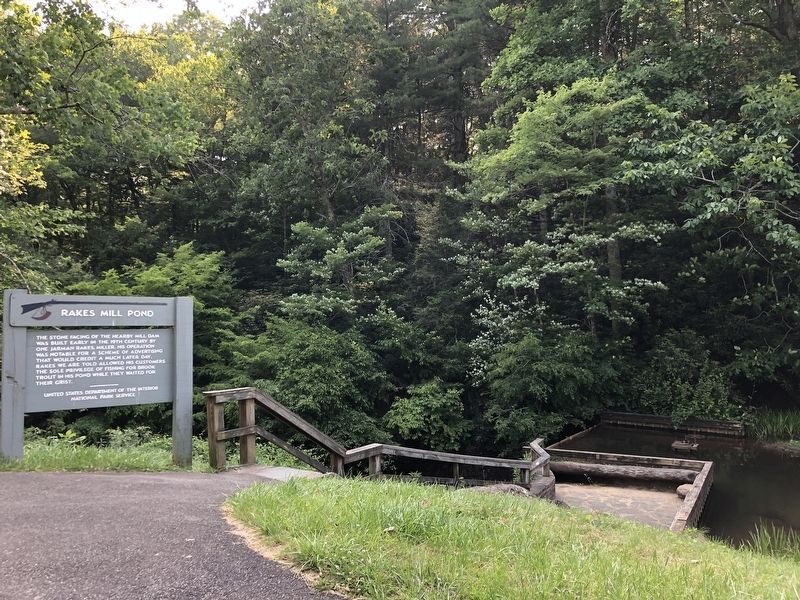
On Blue Ridge Parkway (at milepost 162.4), 0.2 miles south of Buffalo Lane Southeast (Virginia Route 714), on the right when traveling south.
The stone facing of the nearby mill dam
was built early in the 19th century by
one Jarman Rakes, miller. His operation
was notable for a scheme of advertising
that would credit a much later day.
Rakes we are told allowed his customers
the sole . . . — — Map (db m228306) HM
On East Main Street (U.S. 221) at North Locust Street (Virginia Route 8), on the left when traveling east on East Main Street.
Army
American Revolution, 1775 - 1781
Civil War, 1861 - 1865
Operation Desert Storm, 1990 - 1991
Navy
War of 1812, 1812 - 1814
Spanish-American War, 1898
Air Force
World War I, 1917 - 1918
World War II, 1941 - . . . — — Map (db m152068) WM
On North Locust Street (Virginia Route 8) south of Penn Avenue NW, on the right when traveling north.
On March 24, 1865, Union Gen. George Stoneman led 6,00 cavalrymen from Tennesse into southwestern Virginia and western North Carolina to disrupt the Confederate supply line by destroying sections of the Virginia and Tennessee Railroad, the . . . — — Map (db m299100) HM
Near Old Hollow Lane west of Jubal Early Highway ( Route 116), on the right when traveling west.
This is the childhood home of Jubal Anderson Early, who was born on November 3, 1816. He graduated from the U.S. Military Academy at West Point in 1837 and served as a lieutenant in the Seminole War in Florida before resigning in 1838. He practiced . . . — — Map (db m87172) HM
On East Main Street (Ohio River Scenic Byway) (Indiana Route 111) just west of East 9th Street, on the right when traveling west.
This stone marks the western line of the Clark (Illinois) Grant containing 150,000 acres given by the State of Virginia, April, 1784, to General George Rogers Clark, his Officers, and Soldiers as a gratuity for the conquest of the Northwest . . . — — Map (db m194189) HM
On Ekin Avenue east of Thomas Street, on the left when traveling east.
An act of Congress in 1862 established fourteen national cemeteries for the interment of casualties from the Civil War. The first National Cemetery was at Gettysburg, Pennsylvania. The New Albany National Cemetery was one of the first seven . . . — — Map (db m68540) HM WM
On East Main Street (U.S. 221) at North Locust Street (Virginia Route 8), on the left when traveling east on East Main Street.
In Memory of our Fallen Braves, the Confederate Soldiers, from 1861 to 1865.
Stoop Angels, hither from the skies;
there is no holier spot of ground
Than where defeated valor lies,
By mourning beauty crowned.
Floyd County to the Army . . . — — Map (db m151901) WM
On Riner Road (County Route 8) just south of Homestead Road.
Floyd County. Floyd County was named for John Floyd, governor of Virginia from 1830 to 1834. The county was formed from Montgomery County in 1831, with a portion of Franklin County added later. The county seat is Floyd, formerly Jacksonville. . . . — — Map (db m104299) HM
On Huffman Avenue east of Main Street, on the right when traveling east.
John Paul Riddle
Riddle was born May of 1901 to two teachers, Tandy and Bessie Riddle. His mother passed in 1903, and he spent at least some time living with his paternal grandmother on Shelby Creek. It's said that he dreamed of flying even . . . — — Map (db m306441) HM
On Main Street (U.S. 211) at Locust Street (Virginia Route 8), on the right when traveling west on Main Street.
This place became the county seat when Floyd County was formed in 1831. First called Jacksonville for Andrew Jackson, its name was changed to that of the county. The courthouse was built on land given by the Phlegar family. The town was incorporated . . . — — Map (db m65633) HM
On North Main Street north of Rye Cove Road, on the right when traveling south.
We are Virginia's Moonshine Heritage Trail
Our moonshine heritage has deep roots, tracing back to the region's early settlers who relied on the production of illicit distilled spirits as a means of survival and income. While its perception . . . — — Map (db m271604) HM
On Danville Parkway (U.S. 58), on the right when traveling east.
Carroll County. Area 458 Square Miles. Formed in 1842 from Grayson, and named for Charles Carroll of Carrollton, signer of the Declaration of Independence. New River runs through this county.
Floyd County. Area 376 . . . — — Map (db m25470) HM
On South Kanawha Street (West Virginia Route 210) at Howe Street, on the left when traveling north on South Kanawha Street.
On this spot in 1842, James Bird Cole built the first residence in Alfred Beckley's 30-acre "paper town." Cole was born in Floyd County, Virginia, circa 1813. A blacksmith, he also established the first business in Beckley. He built his forge and . . . — — Map (db m177088) HM
On 15th Street at Front Street, on the left when traveling north on 15th Street.
Welcome to Boyd County, Kentucky, home of the Judds (the famous mother/daughter Nashville award winning duo). US 23 was named "The Country Music Highway" in 1994 in recognition of the numerous country music stars from the region. In 2002, through . . . — — Map (db m228072) HM
Near Kentucky Route 114 0.1 miles east of Route 404, on the right when traveling east.
During the first few months of the war, Kentucky remained neutral. The August 1861 election, however, sent a Unionist majority to Frankfort. The new legislature voted to suppress the rebellion, and Federal marshals began arresting men suspected of . . . — — Map (db m69137) HM
On Floyd Pike (Route 221) just east of Borderline Road, on the left when traveling west.
Caroll County. Area 458 Square Miles. Formed in 1842 from Grayson, and named for Charles Caroll of Carrollton, signer of the Declaration of Independence. New River runs through this county.
Floyd County. Area 376 . . . — — Map (db m65640) HM
On Jeb Stuart Highway (U.S. 58) at Widow Drive (County Route 747), on the right when traveling west on Jeb Stuart Highway.
Floyd County. Area 376 square miles. Formed in 1831 from Montgomery, and added to from Franklin. Named for John Floyd, governor of Virginia, 1830–1834. Buffalo Knob is in this county.
Patrick County. Area 485 square . . . — — Map (db m104615) HM
On U.S. 221 0.1 miles south of County Line Road Northeast, on the right when traveling south.
Floyd County. Area 376 square miles. Formed in 1831 from Montgomery, and added to from Franklin. Named for John Floyd, Governor of Virginia 1830-34. Buffalo Knob is in this county.
Roanoke County. Area 305 square . . . — — Map (db m206709) HM
On KY-1428 0.6 miles east of KY-302, on the right when traveling east.
Doris Faye Burchett • James Edison Carey • Glenda May Cisco • Kenneth Forrest Cisco • Paulette Cline • Sandra Faye Cline • Linda Darby • Emogene Darby • James Edward Goble • John Spencer Goble • Anna Laura Goble • Jane Carol Harris • Margaret Louise . . . — — Map (db m212046) HM
On Interstate 77, on the right when traveling north.
A 35 year veteran of
the Virginia Department of Transportation,
was the Resident Engineer
for Carroll and Floyd Counties
during the construction of
this award-winning section of Interstate 77.
He was: a decorated veteran of W.W. II, having . . . — — Map (db m210462) HM
Near West Main Street west of South Locust Street, on the left when traveling west.
Stroll, sit, jump, laugh and sing with the birds. Enjoy yourself on this peaceful woodsy trail, forged by volunteer workers from our Floyd community in partnership with the Town of Floyd. A quiet walk or a bouncy jog will take you from the Warren . . . — — Map (db m299635) HM
On U.S. 221 0.1 miles east of Borderline Road, on the right when traveling east.
CARROLL COUNTY
Area 458 Square Miles
Formed in 1842 from Grayson, and named for Charles Carroll of Carrollton, signer of the Declaration of Independence. New River runs through this county.
FLOYD COUNTY
Area 376 Square . . . — — Map (db m206711) HM
On this site, stood the outbuilding that served as the kitchen for the Stuart family. As was the custom in those days kitchens were housed in buildings separate from the main dwelling for protection against a fire that might erupt as a result of . . . — — Map (db m99842) HM
On Bob Amos Drive at Cedar Creek Road (Kentucky Route 1384), on the left when traveling south on Bob Amos Drive.
Welcome to Pike County, Kentucky, home of Patty Loveless.
US 23 was named “The Country Music Highway” in 1994 in recognition of the numerous country music stars from the region. In 2002 through the efforts of Congressman Harold “Hal” Rogers and . . . — — Map (db m212048) HM
It is a spot just for you, whether you are five or eighty-five. Come on down and run and play, sit a spell, have a picnic or make some music - enjoy yourself and our community.
The park is a dream come true for many people in our community. . . . — — Map (db m299633) HM
On Memorial Avenue (Virginia Route 163) at Orchard Street, on the left when traveling west on Memorial Avenue.
Artist and educator Georgia Morgan studied
painting at Randolph-Macon Woman’s College
and at the Académie Julian in Paris. She was a
co-founder of the Lynchburg Civic Art League
in 1932 and helped establish the city’s Federal
Art Gallery, a . . . — — Map (db m104411) HM
On Memorial Avenue (Virginia Route 163) at Munford Street, on the left when traveling west on Memorial Avenue.
Dental innovator Dr. Robert W. Morgan lived
here. Troubled by the lack of dental care for
soldiers while he served in the Confederate
army, he studied dentistry after the war. During
the 1880s he formulated dental hygiene products
including . . . — — Map (db m104398) HM
Thin black lines indicate changes in relevance. Between each pair of lines entries are ordered geographically but all have the same relevance.
* Inflectional forms of words are their plurals, singulars, and possessives as well as gramatical tenses and similar variations.