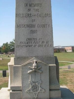
On Pershing Road, on the left when traveling west.
In Memory of the Soldiers and Sailors of Muskingum County Ohio
Erected by Hazlett Post No. 81
Department of Ohio G.A.R.
Donated by Robert A. Parsons as a memorial to Hazlett Post No. 81 G.A.R. — — Map (db m12445) HM
On Arch Hill Road at Murphy Hill Road, on the right when traveling east on Arch Hill Road.
Side A: Salt Creek Bridge
This covered bridge, spanning Salt Creek in Perry Township, Muskingum County was erected in the 1870s. It is a splendid example of an Ohio covered bridge built with Warren type trusses. It is being preserved as an . . . — — Map (db m13344) HM
On 4th Street at Market Street, on the right when traveling north on 4th Street.
One of America's leading architects of the early 20th century, Cass Gilbert (1859-1934), was born in a home that stood at this site. After studying at the Massachusetts Institute of Technology, Gilbert apprenticed with prominent architectural firm . . . — — Map (db m13098) HM
On Main Street (U.S. 40) east of 4th Street, on the left when traveling east.
In 1809 the citizens of Zanesville erected a building on this site which served as the capitol of Ohio from October 1, 1810, until May 1, 1812. The 9th and 10th sessions of the Ohio General Assembly met here before returning to Chillicothe in May . . . — — Map (db m275) HM
On Putnam Avenue (Ohio Route 93) north of Jefferson Street, on the left when traveling south.
Constructed of sandstone quarried from nearby Putnam Hill, the Stone Academy dates to 1809. The Springfield School House Company erected the building, it is believed, to lure the statehouse from Chillicothe. However, when Zanesville was chosen as . . . — — Map (db m172342) HM
A.A. Guthrie chairs the second State Abolition
Society Meeting in Granville, Ohio,
serving as society president. This
meeting also has to contend with
mob violence. — — Map (db m280752) HM
Side A
In the early 1800s, opposing attitudes existed in the separate communities of Putnam and Zanesville. Anti-slavery New Englanders settled Putnam while pro-slavery Virginians and Kentuckians settled Zanesville. The Emancipation Society . . . — — Map (db m94534) HM
Vice President Thomas A. Hendricks was born at this site on September 7, 1819. While still a baby, Thomas' family moved to Indiana and he grew up and rose to prominence in the Hoosier State. Hendricks served consecutively in the Indiana State . . . — — Map (db m13097) HM
On North Street (Ohio Route 66) near West River Road, on the right when traveling west.
Original sandstone piers built in 1888
Bridge reconstructed in 2023
County Commissioners
Cindy S. Cameron •
Mollie S. Crooks •
Melissa J. Bell
County Engineer
Mark J. Eicher, P.E., P.S.
Project Designer
Shawn E. . . . — — Map (db m284075) HM
On County Road 495 at State Route 16, on the right when traveling west on County Road 495.
Side A:
The acknowledged host of the Underground Railroad in Coshocton County was Prior Foster, a well respected African American who lodged fugitive slaves in his shanty at Harbaugh Corner. He fed, sheltered, and clothed them and then . . . — — Map (db m36227) HM
On Arch Hill Road (County Road 82) at Murphy Hill Road, on the right when traveling east on Arch Hill Road.
Residents near Johnson's Mill on Big Salt Creek petitioned the Muskingum County Commissioners in June 1875 for a bridge. A year later, they agreed to pay Jesse Romine $445 for stone abutments and Thomas Fisher $646 for an uncovered 80' Warren truss . . . — — Map (db m284074) HM
On Ridge Street at Locust Street, on the left when traveling west on Ridge Street.
Underground Railroad Crossings
Underground Railroad crossings, agents, and conductors were common along the Ohio River between Washington County, Ohio and Wood County, Virginia. At Constitution, six miles upriver from Belpre, Judge Ephraim . . . — — Map (db m20130) HM
On West Main Street (Historic National Road) (U.S. 40), on the right when traveling east. Reported missing.
World famous part of the Old National Road.
Maintained by Muskingum County Marker by Ohio Society of Professional Engineers Approved by the Ohio Historical Society — — Map (db m8518) HM
On Linden Avenue north of Main Street (U.S. 40), on the right when traveling south.
World famous part of the Old National Road.
Maintained by Muskingum County. Marker by Ohio Society of Professional Engineers. Approved by the Ohio Historical Society. — — Map (db m9555) HM
On Main Street (U.S. 40), on the right when traveling south.
World famous part of the Old National Road.
Maintained by Muskingum County. Marker by Ohio Society of Professional Engineers. Approved by the Ohio Historical Society. — — Map (db m9559) HM
On Mahoning Avenue 0.1 miles north of High Street NW, on the right when traveling south.
Leicester King
Born in Connecticut in 1789, Judge Leicester King and his wife Julia Ann Huntington King, moved to Warren in 1817 from Westfield, Massachusetts. He was one of the principle promoters of the Pennsylvania and Ohio Canal, which . . . — — Map (db m65445) HM
On Old National Road (U.S. 40), on the left when traveling east.
For nearly fifty years prior to 1914, almost no maintenance had been carried out on “the pike”, the National Road. By the early 20th century, bicyclists, automobile owners, postal service, and the trucking industry were demanding better . . . — — Map (db m98521) HM
On East 11th Avenue at Essex Avenue, on the right when traveling north on East 11th Avenue.
Flint is a variety of chert, a rock composed of extremely tiny crystals of the mineral quartz. Flint is hard, and owing to the way it fractures, it can be worked (knapped) to form sharp edges. Ohio flint was especially prized by Native Americans, . . . — — Map (db m280881) HM
On 5th Street at Shinnick Street, on the left when traveling south on 5th Street.
This is a “rubbing” wall which depicts the proud
history of Zanesville and Muskingum County.
Historic images are surrounded by tiles
depicting foliage from the Ohio Buckeye tree.
The images are in order of their dates
beginning with the . . . — — Map (db m231257) HM
On Muskingum Avenue west of Putnam Avenue ( Route 93), on the right when traveling west.
(Front): A tale of two cities. During the time of the Underground Railroad, Zanesville and Putnam were two communities separated by the Muskingum River with two distinct moral views. The people in Zanesville were proslavery, in Putnam . . . — — Map (db m5624) HM
On Canal Road (County Route 100), on the right when traveling north.
How Does The Canal System Work?
The Ohio-Erie Canal was constructed with two summit levels: one near Akron in Summit County and the other, the Licking Summit, in Licking and Fairfield Counties. Reservoirs of water were created on both summit . . . — — Map (db m250206) HM
Near International Road (Local Route 216) east of Big Muskie Drive ( Route 284).
Near this location stood the settlement of African American families known as
“The Lett Settlement.” The Lett Settlement was a self-sustaining community of mixed race families, including the Caliman, Guy,
and Lett families. The . . . — — Map (db m135923) HM
Near S.O.M. Center Road, on the right when traveling south.
Self-reliance, hard work, and a sharp axe were required to thrive here. Abram Garfield married Eliza Ballou in 1820 in Muskingum County, Ohio. In 1827 the Garfield family bought these 50 acres and moved here, bringing their three surviving . . . — — Map (db m279325) HM
On Broad Street (U.S. 40) at Front Street, on the right when traveling west on Broad Street.
The Refugee Tract of 100,000 acres of land was a strip four and one half miles wide extending forty-eight miles eastward from the Scioto River at Columbus through parts of Franklin, Fairfield, Perry, Licking and Muskingum Counties. It was granted . . . — — Map (db m36673) HM
On Southgate Parkway (Ohio Route 209) at Turner Avenue, on the right when traveling north on Southgate Parkway.
In memory of
The Founders Of Cambridge
June Second 1806
and of the pioneers of this region.
Northwest Territory 1787 •
Washington County 1788 •
Survey of Military Lands 1796 •
This 4000 acre tract patented 1801 •
State of . . . — — Map (db m209849) HM
Thirty-thousand years ago, the streams and rivers in this area flowed north. A ridge extended across what is today the Muskingum-Morgan County line about seven miles south of the Philo Lock. When the Wisconsin Glacier moved down from Canada 25,000 . . . — — Map (db m13334) HM
Near Putnam Avenue north of Jefferson Street, on the right when traveling north.
President Abraham Lincoln issues the Emancipation Proclamation, declaring that slaves in areas of rebellion against the United States are Free. The 62nd Ohio Volunteer Infantry, containing many Zanesville and Putnam volunteers participates in the . . . — — Map (db m280937) HM
On West Main Street west of South Isabella Street, on the left when traveling west.
The Act of Congress in 1806, which authorized the construction of the National Road, required that mile markers be placed at regular intervals. These reference points reassured travelers that they were following the correct route. They also . . . — — Map (db m175105) HM
On National Road (U.S. 40) at Patterson Road, on the right when traveling east on National Road.
The Act of Congress in 1806, which authorized the construction of the National Road, required that mile markers be placed at regular intervals. These reference points reassured travelers that they were following the correct route. They also . . . — — Map (db m271671) HM
This covered bridge once spanned Brannon's Fork near Young Hickory in Muskingum County. The bridge was dismantled in the 1960's because land surrounding it was to be strip mined.
Arthur Wesner purchased the bridge in 1967 and reassembled it on . . . — — Map (db m166064) HM
On Broadway Street (Route 266), on the right when traveling east.
Front Text : "Underground Railroad"
Some of the main Ohio Underground Railroad lines that fugitive slaves
used on their way from the Ohio River toward Canada and freedom
followed the Muskingum River. These lines, however, were not
easy. . . . — — Map (db m80328) HM
Near Marcy Road (County Route 89) 0.4 miles west of Winchester Southern Road ( Route 674), on the right when traveling west.
This covered bridge once spanned Brannon's Fork near Young Hickory in Muskingum County. The bridge was dismantled in the '60s because land surrounding it was to be strip-mined.
Arthur Wesner purchased the bridge in 1967 and reassembled it on . . . — — Map (db m249563) HM
The Muskingum County Abolition
Society petitions the Ohio Legislature
to allow African Americans to testify in
court and participate in the school fund.
They also petition the United States
Congress to abolish slavery in Washington
D.C. and . . . — — Map (db m280743) HM
On West Main Street (U.S. 40) west of Oakland Avenue, on the right when traveling west.
Nelson T. Gant as one of Zanesville’s most prominent African American citizens. Born into slavery on the Woodburn Estate of John Nixon of Loudoun County, Virginia on May 10, 1821, Nelson was given is freedom by the provisions of his master’s will in . . . — — Map (db m43961) HM
On Woodlawn Avenue at Jefferson Street, on the right when traveling south on Woodlawn Avenue.
has been placed on the
National Register
of
Historic Places
by the United States
Department of the Interior
National Underground
Network to Freedom — — Map (db m316372) HM
On Main Street (U.S. 40) west of North 5th Street, on the right when traveling west. Reported permanently removed.
1880 - William Green opens the first tavern in what is now Zanesville.
1801 - Zanesville receives its name from a government official. (Formerly known as Westbourne).
1810-1812 - Zanesville is the capital of Ohio.
1817 - . . . — — Map (db m272136) HM
On Main Street (U.S. 40) at 5th Street, on the right when traveling west on Main Street.
297 men from Muskingum Co. Ohio died in World War II 1941-1945, and the Korean War 1950-1953. This monument is a tribute to that sacrifice. 297 empty helmets (symbolic of each fallen soldier, sailor, marine, and airman) have a name upon them. . . . — — Map (db m274472) WM
On Old National Road (U.S. 40), on the right when traveling west on Old National Road.
Zanesville, the county seat of Muskingum County, was
named for Colonel Ebenezer Zane. In 1796 Congress
commissioned Colonel Zane to build a road from
Wheeling, Virginia (later West Virginia) to Limestone,
Kentucky (present Maysville, Kentucky). . . . — — Map (db m194090) HM
Thin black lines indicate changes in relevance. Between each pair of lines entries are ordered geographically but all have the same relevance.
* Inflectional forms of words are their plurals, singulars, and possessives as well as gramatical tenses and similar variations.