On Rizal Avenue Extension, on the right when traveling west.
Itinatag bilang bisita ng Tondo, 21 Mayo 1599. Naging parokya sa patronato ni San Bartolome sa Tambobong (ngayo'y Malabon), 17 Mayo 1614. ipinatayo ang simbahan ni Padre Diego de Robles yari sa bato, 1622. Ipinagawa ang harapan ng . . . — — Map (db m240665) HM
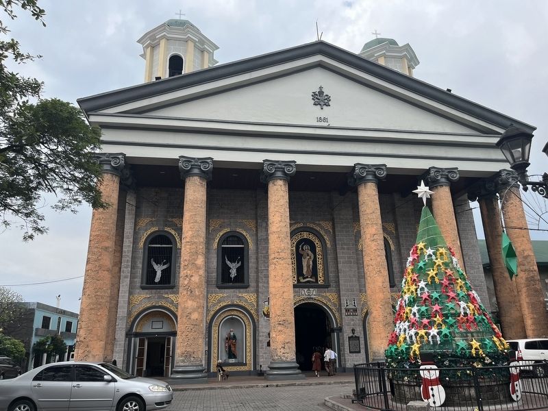
On Quintin Paredes Street near Ongpin Street, on the right when traveling north.
In Tagalog: Dito itinatag ng mga paring Dominkano ang misyon para sa mga Intsik noong 1587 at naging parokya noong 1596. Nasira nang pumasok ang mga Ingles noong 1762. Inilipat sa paring Sekular noong 1766 at ibinalik sa Dominikano noong . . . — — Map (db m25024) HM
In Tagalog:
Si Teodora Alonzo, ina in Rizal, ay namatay noong ika-16 ng Agosto ng 1911 sa isang bahay na nakatayo sa pook na ito (ngayo'y blg, 476-478) at ari ni Gng. Luisa Lichauco.
Translated, the marker . . . — — Map (db m25025) HM
On Juan Luna Street at Reina Regente, on the right on Juan Luna Street.
Marker Panels 1 and 2: on the north face of the memorial's base with text in Chinese and English [portions illegible] - listed units include: “Phil-Chinese Volunteer Corps”, “Anti-Jap[anese] & Puppets,"
"... Grand . . . — — Map (db m64666) WM
On Plaza Lorenzo Ruiz [Quintin Paredes Street] at Ongpin Street, on the right when traveling north on Plaza Lorenzo Ruiz [Quintin Paredes Street].
His Eminence, Jaime Cardinal Sin. D.D. Archbishop of Manila commissioned Very Rev. Msgr. Federico V. Navarro to start the restoration and reconstruction of this church on January 1977, which was finished in January 1984.
In May 9, 1985, the . . . — — Map (db m209425) HM
On Quintin Paredes Road, on the right when traveling west.
In Tagalog: Makabayan at pilantropo. Isinilang sa Binondo, Maynila, 28 Pebrero 1847. Nahalal bilang Teniente Primero de Mestizos ng Binondo, 1883-1885. Itinatag ang El '82, unang tindahang gumamit sa paraang "fixed price" sa kalye Colon . . . — — Map (db m25021) HM
In Tagalog:
Sa bahay na ito, 843 Urbiztondo, Isinilang si Antonio Luna noong ika-29 ng Oktubre, 1866. Anak nina Joaquin Luna de San Pedro at Laureana Novicio at kapatid ni Juan Luna, ang pintor. Parmasyutiko at kimiko. Bantog na . . . — — Map (db m25029) HM
On Juan Luna Street just south of Reina Regente, on the left when traveling east.
The new Plaza San Lorenzo Ruiz was formerly known as Plaza Calderon de la Barca, a noted Spanish playwright. In 1981 it was renamed after the first Filipino saint, Lorenzo Ruiz, where his statue stands, in honor of this Binondo . . . — — Map (db m72413) HM
This house was occupied by Dr. Pio Valenzuela together with Ulpiano Fernandez and Faustino Duque, Filipino printers who turned out for Dr. Valenzuela and Emilio Jacinto 2,000 copies of the newspaper entitled “Ang Kalayaan,” giving . . . — — Map (db m25221) HM
On Escolta Street at Burke Street on Escolta Street.
Cardiologist, Philanthropist. Born February 17,1873, San Miguel, Manila. Obtained the degree of Doctor of Medicine at the University of Dublin, Ireland. Returned to practice his profession in Manila, 1900. Introduced and installed the first . . . — — Map (db m25027) HM
On Quezon Boulevard near Magallanes Drive, on the right when traveling south.
Born of humble parents in Tondo, Manila on November 1863. Andres Bonifacio founded the Katipunan, the secret society that launched the revolution against Spain in Agusut 1896.
He wrote the Katipunan decalogue, some patriotic poems and essays. And . . . — — Map (db m25079) HM
In Tagalog: Itinayo noong 1606 na yari sa kawayan, mulawen, at pawid, ang simbahan ng Nuestra Señora de Guia ay makailang nawasak dahil sa lindol. Muling itinayo noong 1810 at nawasak noong 1945 sa labanan ng Maynila, ang imahen ng Nuestra . . . — — Map (db m25094) HM
Founded on 30 June 1905 in Manila at the Initiative Concepcion Felix and with the collaboration of Trinidad Rizal, Clemencia Lopez, Bonifacia Delgado de Barretto, Maria Arevalo, Sofia Reyes, Helen C. Wilson, Paz Natividad VDA. de Zulueta, Maria F. . . . — — Map (db m25095) HM
On Teodoro M. Kalaw Sr. Street near General Luna Street, on the right when traveling east.
[Main Marker In Tagalog:]
Kauna-unahang Iglesia ng Protestante sa Pilipinas. Nagsimula noong Marso 5,1899 upang mangaral sa mga Pilipino. Pinasinayaan ang unang Kapilya sa Pook na ito noong Disyembere 23,1901. Pinalitan ng Batong gusali . . . — — Map (db m25045) HM
The Chapel built here in 1883 was used as Parish Church of Paco from 1898 to 1909. Parish of San Vicente de Paul erected in 1909. Present church built of concrete in 1912 to Commemorate the Fiftieth Anniversary of the arrival of the Vincentians and . . . — — Map (db m25042) HM
Tagalog Itinatag bilang Cosmopoilta Student Church sa ilalim ng Pihlippine Methodist Church, Marso 1933. Itinalaga sa pook na ito, 1936. Kanlungan at sentro ng gawain ng mga kasapi ng simbahang lihim na kabilang sa kilusang . . . — — Map (db m25103) HM
Tagalog
Nagunguna, Independiente at Pambansang Institusyong Masoniko. Itinatag ng tatlong Lohiyang Amerikano sa pahintulot ng Grand Lodge of California ng Estados Unidos ng Amerika, sa kumbensyon sa templo ng masoniko, San Luis . . . — — Map (db m25096) HM
This historical marker is being offered in memory of the Filipina victims of Japanese Military sexual slavery during the Second World War.
During the Japanese occupation of the Philippines approximately 1,000 women became victims of military . . . — — Map (db m62969) HM
On Bonifacio Drive (Route R1) at Padre Burgos Avenue, on the right when traveling north on Bonifacio Drive.
National hero of Cuba, writer, poet, journalist, pedagogue, orator. Outstanding politician and revolutionary, who organized and led the struggle for independence of his country, promoted that of Puerto Rico and Latin American and Carribean unity. . . . — — Map (db m239106) HM
On Roxas Boulevard north of South Road, on the right when traveling north.
Act No. 243 granted the use of public land in Luneta as a site for the Jose Rizal Monument, 28 September 1901. The monument, entitled "Motto Stella," was the entry of Swiss sculptor Richard Kissling to the international design contest for the . . . — — Map (db m239105) HM
On Quezon Boulevard, on the right when traveling north.
In Tagalog: Nagsimula bilang isang pambansang tanghalan ayon sa disenyo ni arkitekto Juan Arellano. Pinasinayaan noong 1931. Naging tanghalan ng mga artistanf Pilipino at banyaga. Nagpalabas ng mga opera, pageant, at dulang Kastila at Ingles . . . — — Map (db m25090) HM
Tagalog: Itinatag sa bisa ng Kautusan bilang 1688 ng Komisyon ng Pilipinas bilang dibisyon ng Kagawaran ng Kalusugan, 1907 sa pamamagitan ni Dean C. Worcester, inilagay ang Panukulang bato Disyembere 8, 1908; Natapos, Nobyembere 30,1909. . . . — — Map (db m25078) HM
In Tagalog: Itinatag bilang tanggapan ng koreo sa Maynila 1767; Itinaas bilang distritong Pangkoreo ng Espanya, 1779; Nag panibagong tatag, 5 Disyembere 1837; Naging pangunahing sentrong pangkoreo, 1838, naging kasapi ng Universal Postal . . . — — Map (db m25080) HM
In memory of Olivia Salamanca, M.D., pioneer woman physician of the Philippines. Born in San Roque, Cavite on 1 July 1889; appointed government scholar in 1905; Studied in Drexel Institute, Philadelphia. Died on 11 July 1913. A devoted and compenent . . . — — Map (db m25077) HM
On Taft Avenue at Mayor Antonio Villegas Street on Taft Avenue.
In Tagalog: Na nag-iwan sa amin ng isang dakilang pamana na may karangalan dahil sa ginawa nilang pagtulong sa mga kulang-palad na walang kakayahan, sa pagtatanggol ng mga naapi, sa pagsasanggalang ng patrimonyo ng lungsod at sa walang takot . . . — — Map (db m25093) HM
On Taft Avenue at Mayor Antonio Villegas Street on Taft Avenue.
Late in the afternoon of February 3, 1945 two groups of the flying column of the 1st Cavalry Division, including the attached 44th Tank Battalion, entered Manila, with the first group taking possession of Malacanang Palaca and the second group . . . — — Map (db m25228) HM
On Postigo Lucia Street, on the right when traveling east.
Ang paglunsad ng hukbong Amerikano sa Lingayen Enero 3, 1945 ang simula ng paglaya ng Maynila at mga karatig pook sa Gitnang Luzon. Pinangunahan ng ika-37 Impanteriya na pinalakas ng Unang Kabalyaria at mga gerilyang Pilipino ang . . . — — Map (db m215675) HM
On Arzobispo Street, on the left when traveling west.
Here once stood the Ateneo de Manila. Founded in 1817 as Escuela Pia de Manila. Administered by government in 1831 and renamed Escuela Municipak de Manila. Turned over to the Jesuits in 1859. Renamed Ateneo Municipak de Manila in 1865. Exclusive . . . — — Map (db m25162) HM
On Cabildo Street, on the right when traveling north.
In Tagalog:
Ipinatayong tahanang ng Cabildo at iba pang pinuno ng pamahalaan ng Lungsod ng Maynila. Inilagay ang panulukang bato, 1735 natapos, 1738. Nasira ng lindol 1863; muling ipinatayo, 1879. Naging luklukan ng Pamahalaang kolonyal na . . . — — Map (db m25157) HM
On Santa Lucia Street, on the right when traveling south.
On this site stood the house of the Beaterio de la Compañia de Jesus, first Filipino congregation of religous women. Founded in 1684 by Ignacia del Espiritu Santo, a Chinese mestiza from Binondo. The Archbishop of Manila approved the rules of the . . . — — Map (db m25230) HM
On Beaterio Street near Muralla Street, on the left when traveling west.
Here once stood the Beaterio-Colegio de Santa Catalina. Order founded in 1633 by Mother Francisca del Espiritu Santo. Known as Dominican Sisters of the Tertiary Order. Order recognized by King in 1716. Authorized to offer teacher-training courses in . . . — — Map (db m25275) HM
On Muralla Street, on the left when traveling north.
Here once stood the Chapel of the Franciscan Venerable Third Order. Housed the Congregation of the Third Order of Saint Francis established in 1611 by Fr. Jose de Santa Maria, O.F.M. Chapel built in 1618. Stone edifice built in 1678. Renovated from . . . — — Map (db m25237) HM
On General Luna Street, on the right when traveling south.
Oldest stone church in the Philippines. Plans were approved in 1587 and completed in 1607 under the supervision successively of the Augustinian Fathers Francisco de Bustos, Ildefonso Perez, Diego de Avila and brother Alonso de Perea. Its architect . . . — — Map (db m25040) HM
On General Luna Street, on the right when traveling south.
Here once stood the Colegio de Santa Isabel. Founded in 1632 by the Hermandad de la Santa Misericordia. Granted royal patronage in 1733. Administered by Daughters of Charity since 1862. First office of the Monte de Piedad y Caja de Ahorros . . . — — Map (db m25163) HM
On Santo Tomas Street, on the left when traveling west.
Here stands the Colegio de Santa Rosa. Founded in 1750 by Mother Paula de Santissima Trinidad. Formerly called Beaterio y Casa Ensenanza and administered to the needs of the Filipina orphans. Granted royal patronage in 1774. Administration . . . — — Map (db m25282) HM
On Muralla Street near Anda Street, on the left when traveling north.
Founded by Diego de Santa Maria, O.P., in 1630. This institution absorbed the school of Juan Geronimo Guerrero in 1638. In 1648, after its building had been detroyed by the earthquake of 1645. The College was removed to the Parian, on which site it . . . — — Map (db m25274) HM
On Magallanes Drive, on the right when traveling north.
The Cruceiro or wayside stone across is an expression of a truly popular devotion of the Christian in the autonomous region of Galicia in northwestern Spain. It is a symbol of divine protection and place of prayer. It guides the pilgrims on their . . . — — Map (db m25290) HM
On Sta. Lucia Street near Sta. Potencia Street, on the right when traveling south.
On this site, Cuartel de la Artilleria de Montana was built by Thomas Sanz, Engineer of the army during the Administration of Governor General Jose Basco y Vargas, 1781. Used as barracks by The Philippine Constabulary, 1901. Became The Philippine . . . — — Map (db m25227) HM
On General Luna Street, on the right when traveling south.
This site was formerly occupied by the stately residence of Captain Manuel Estacio Venegas, Secretary to Governor General Diego Fajardo. Venegas died on March 7, 1660, a prisoner at Fort Santiago. His residence was confiscated and became the Palace . . . — — Map (db m25155) HM
On Muralla Street near Real Street, on the left when traveling north.
Here once stood the Hospital de San Juan de Dios. First known as the "Hospitalito de Santa Ana". Built in 1578 by Franciscan lay brother, Juan Clemente. Managed by the Hermandad de la Santa Misecordia with spiritual administration handled by . . . — — Map (db m25243) HM
On General Luna Street, on the left when traveling south.
Here once stood the first permanent house of the Franciscan Capuchin friars in 1891. First chapel built in 1892. Dedicated to our Lady of the Divine Shepherd (Divina Pastora). Statue of Our Lady of Lourdes carved by Filipino sculptor Manuel . . . — — Map (db m25242) HM
On Sto. Tomas Street, on the right when traveling east.
First cathedral built in 1581. Damaged by a typhoon, 1582 and destroyed by fire, 1583. Second Cathedral built of stone in 1592 and partially destroyed by earthquake, 1600. Third Cathedral built in 1614 and destroyed by the earthquake of 1645. Fourth . . . — — Map (db m25153) HM
On Victoria Street at Muralla Street, on the left when traveling west on Victoria Street.
In Tagalog: Ang paaralang ito ay naitatag ng mga Kastila sa utos ng Ayuntamiento de Manila sa daang Victoria, Intramuros noong 1892. Pinangalanang "Escuela Municipal de Manila". Dito rin itinatag ng mga Amerikano ang kauna-unahang paaralang . . . — — Map (db m25235) HM
On Anda Street near General Luna Street, on the left when traveling south.
This monument is erected in memory of the more than 100,000 defenseless civilians who were killed during the Battle for the Liberation of Manila between February 3 and March 3,1945. They were mainly victims of heinous acts perpetrated by the . . . — — Map (db m25517) HM
On Muralla Street, on the right when traveling north.
Francisca de Fuentes, was born to Don Simon de Fuentes and Ana Maria Tamayo del Castillo in the City of Manila in 1647. Widowed and childless herself after a brief marriage, she dedicated herself to helping the sick, the needy and the young. In . . . — — Map (db m25291) HM
On Victoria Street at Santa Lucia Street on Victoria Street.
On this site once stood the headquarters of General Douglas MacArthur commanding general of the United States Army Forces in the Far East (USAFFE)
Popularly known as "No. 1 Victoria St." it was located opposite the USAFFE headquarters at the . . . — — Map (db m25241) HM
On Cabildo Street, on the left when traveling south.
In Tagalog:
Sa pook na ito nanirahan si Padre Burgos mula noong 1865 hanggang 1872 at nagtrabaho para sa mga pagbabago sa simbahan sa ilalim ng Espanya, naging Kura Paroko ng Parroquia del Sagrario, Fiscal Eclesiastico at pansamantalang . . . — — Map (db m25158) HM
On Arzobispo Street, on the right when traveling south.
Here once stood the Archbishop's Palace. Acquired by Archbishop Miguel de Poblete (1653-1667) for use as residence. Housed the offices of the Archbishop of Manila and the Catholic Church in the Philippines. Underwent major repairs after damage from . . . — — Map (db m25160) HM
On Solana Street at Muralla Street, in the median on Solana Street.
Named Plaza de los Mártires de la Integridad Nacional in 1897 in memory of Spanish Soldier who died in the encounters of August 1896, was rebuilt by the Intramuros Administration and opened on July 1982.
Manuel C. Elizalde Jr. donated the stone . . . — — Map (db m25288) HM
On Andres Soriano Jr. Street, on the right when traveling east.
Formerly called Plaza Mayor. Converted into a park in 1797. Renamed Plaza McKinley after U.S. President William McKinley in 1901. Renamed Plaza de Roma in 1961 to honor Sacred College of Cardinals in Rome following the elevation of . . . — — Map (db m209467) HM
On Santo Tomas Street, on the left when traveling north.
Lot originally purchased by the Dominican Order in 1627 for their cemetery and garden. Bought by city government in 1861 as a public plaza. Given to the University of Santo Tomas in 1879. Bronze statue of U.S.T. founder Archbishop Miguel de . . . — — Map (db m25285) HM
On Anda Street at General Luna Street, on the left when traveling south on Anda Street.
Made part of Santa Isabel College which lacked an open space characteristic of Spanish buildings. Empty lot called Sampalucan along Calle Anda joined to enlarge plazuela in the 18th century.
Restored in 1983. Monument dedicated to . . . — — Map (db m25164) HM
On Muralla Street, on the left when traveling north.
Here once stood the San Francisco Church and Convent. Built by the Franciscans who arrived in the Philippines in 1578. First church and convent dedicated to Our Lady of Angels (Nuestra Senora de los Angeles). Destroyed in 1583. A new stone . . . — — Map (db m25236) HM
On Arzobispo Street, on the right when traveling west.
Here once stood the second San Ignacio Church and the Casa Mission of the Jesuit Order. Built from 1878 to 1889. Designed by first Filipino architect Felix Roxas, Sr. Neo-classical in style with two towers. Constructed under the direction of Jesuit . . . — — Map (db m25161) HM
On Magallanes Drive near Muralla Street, on the right when traveling east.
Here once stood the Santo Domingo Church and Convent of the Dominican Order. First built in 1588. Collapsed in 1589 due to poor foundations. Rebuilt in stone 1592. Burned in 1603. Constructed for the third time but destroyed in 1645 earthquake. . . . — — Map (db m25287) HM
On Recoletos Street at Muralla Street, in the median on Recoletos Street.
Sa pook na ito ipinatayo ang simbahan at kumbento ng San Nicolas de Tolentino ng Order of Augustinian Recollects (OAR) sa kagandahang-loob ni Bernardino del Castillo Maldonado, 1608. Nagsilbing pangunahing kumbento ng mga Recoletos sa . . . — — Map (db m25233) HM
On Muralla Street, on the left when traveling east.
This block was occupied by the Jesuits upon their arrival in 1581 until their expulsion in 1768. The Church of Santa Ana (1587), Colegio Maximo de San Ignacio (1595), Colegio de San Jose (1601), and the first church and convent of San Ignacio (1626) . . . — — Map (db m25232) HM
On Muralla Street, on the left when traveling north.
Educator and first registered architect. Born in Manila, December 21,1888. Studied at Ateneo de Manila and Liceo de Manila, completed secondary education at Boones Preparatory School in Berkeley, California, 1907. Obtained the degree of bachelor in . . . — — Map (db m25293) HM
On Solana Street, on the left when traveling north.
Here once stood the Univerity of Santo Tomas, the oldest university in Asia. Founded in 1611. First called Colegio Seminario de Santo Tomas de Nuestra del Rosario. Authorized to grant academic degrees in 1624. Raised to the rank of . . . — — Map (db m25286) HM
On M. Naval Street at Los Martires Street on M. Naval Street.
Itinatag ng mga agustino bilang visita
ng Tondo, 21 mayo 1599. Kalauna'y
itinalaga ang Navotas bilang baryo ng
Malabon at ipinailalim sa parokya ng San Bartolome. Pormal na nahiwalay sa
malabon ang navotas, 11 hunyo 1859, . . . — — Map (db m240522) HM
On Plaza Major just north of España Street, on the right when traveling west.
Through these portals passed up to ten thousand Americans and other nationals of the free world who were interned within these walls by the Japanese military. Suffering great physical privation and national humiliation from January 4, 1942, until . . . — — Map (db m72731) HM WM
Panel 1: Founded in 1611 by legacy of Archbishop Miguel de Benavides. Authorized to confer degrees in 1624. Granted university privileges in 1645 by Innocent X upon Philip IV’s request. Made a royal university in 1785 by Charles III and a . . . — — Map (db m72333) HM
On UST's Plaza Mayor at Dr. José Rizal Lane, 0.3 kilometers north of España Blvd. when traveling south.
Tagalog text:
Unang itinatag sa Intramuros bilang Seminaryo ng
Colegio de Nuestra Señora del Santisimo Rosario
ni Arsobispo Miguel de Benavides, O.P. 28 Abril 1611.
Pinangalanang Colegio de Santo Tomas bilang
pag-alaala kay . . . — — Map (db m72769) HM
Manila American Cemetery, the largest of 24 cemeteries built and administered by the American Battle Monuments Commission, both in area and number of graves. 16,636 military dead of the United States of America from World War II rest here, . . . — — Map (db m73079) HM WM