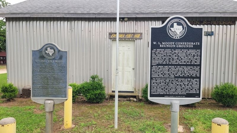
On East Commerce Street (U.S. 84) at Oak Street, on the right when traveling east on East Commerce Street.
Came to Texas from Virginia, 1852. Organized and was captain of Co. G, 7th Texas Infantry, the first Freestone County unit to go into battle in the Civil War.
Captured at Fort Donelson, Tenn. Feb. 1862. Exchanged, soon won promotion to colonel . . . — — Map (db m271690) HM
On East Water Street at North Rusk Street on East Water Street.
A native of England, Thomas C. Snailum came to Texas in 1834, settling in Bastrop. He enlisted in the Texas Army in 1836, served during the Texas Revolution, and settled in Nacogdoches after the war. In 1840 Snailum married Mary Ann Rogers . . . — — Map (db m224179) HM
On East Commerce Street (U.S. 84) at South Mount Street, on the left when traveling east on East Commerce Street.
Formed from Limestone County
Created September 6, 1850
Organized January 6, 1851
So named from the nature of
its stone
County Seat, Fairfield
Formerly known as Mound Prairie — — Map (db m121878) HM
Near County Highway 731 1.2 miles east of Farm to Market Road 80.
A veteran of 1835 Texas armed resistance to Mexican forces. Participated in the Grass Fight (Nov. 26), and in victory at San Antonio on Dec. 10, 1835. Haley was born in Tennessee. In 1824, he moved to present Shelby County, Texas. For his services . . . — — Map (db m171529) HM
On South 9th Street at East Main Street (Business U.S. 84), on the left when traveling south on South 9th Street.
Pharmacist John F. Wallace (1861-1966) moved to Teague in 1908. He lived at this address as early as 1912 and built this house for his family about 1928. John F. Wallace represented Freestone County in the Texas House of Representatives from 1921 . . . — — Map (db m171482) HM
On Moody Street west of N Bateman Road, on the left when traveling east.
Built 1860 by W.L. Moody, noted county merchant, for his bride, Elizabeth Bradley; sold after he moved to Galveston to his father-in-law, F.M. Bradley, one of this county's most influential men. Price was $2,800 in gold.
In Greek Revival style, . . . — — Map (db m272124) HM
On State Highway 105 at Cape Conroe Drive, on the right when traveling west on State Highway 105.
Joseph L. Bennett, who came to Texas in 1834 and settled in this area, joined the Texas army in early 1836. As captain of a company of local volunteers, he left this area about March 1, 1836, to lead his troops to aid Texan forces at the Alamo. . . . — — Map (db m56760) HM
On County Road 1131 0.8 miles north of County Road 1140.
Planter, soldier, civic leader. Born in Georgia. Commissioned a captain in U. S. Army in Florida in 1837; a major, 1846. Came to Freestone County in 1854. For headquarters on his 10,550-acre plantation, built (1860) at this site a 12-room stone . . . — — Map (db m294828) HM
Established in 1867 as a final resting place for William Bonner, Dr. John Bonner, and their descendants. The two brothers, natives of South Carolina, came to Texas in the early 1850s, settling in Freestone County. Here they amassed thousands of . . . — — Map (db m26474) HM
On Market Street 0.1 miles 23rd Street, on the right when traveling east.
Famed for a long career of dynamic leadership in Galveston business, civic affairs, and philanthropy.
Born in Freestone County; son of William Lewis and Pherabe Elizabeth Bradley Moody. Educated at Virginia Military Institute, he later . . . — — Map (db m307805) HM
On Farm to Market Road 2547 0.1 miles south of Farm to Market Road 833, on the right when traveling north.
This historic sanctuary is one of the oldest church buildings in Freestone County. People of the Stewards Mill community held church services in private homes or in the schoolhouse prior to its construction. On Oct. 7, 1876, the Awalts, Bonners, . . . — — Map (db m272112) HM
On State Highway 84 1.7 miles Farm to Market Road 489, on the left when traveling east.
Commissioners courts in Texas usually furnished to soldiers enlisting in the Civil War their uniforms, guns, blankets--and sometimes even their horses. The county courts also aided dependents, war orphans and widows. Further, they recognized local . . . — — Map (db m51647) HM
On County Road 1140 at County Road 1131, on the right when traveling north on County Road 1140.
Settlement of this community began in the 1850s, about the time the Texas Legislature created Freestone County out of Limestone County. Early settlers included the Smith, Claypool, Henderson, Wooldridge, Kennedy, Lemmon, Manahan, Cannon, Carroll, . . . — — Map (db m294830) HM
Near Cemetery Road 0.2 miles west of County Highway 853.
Outstanding educator, scholar, civic leader, and historian. Born in Paris (Tex.), son of W.J. and Elizabeth Kilpatrick Notley. Took B.A. and M.A. degrees, University of Texas. Served as teacher and school administrator, 1912-53. Chairman of . . . — — Map (db m171486) HM
On Highway 19 3 miles north of Highway 1280, on the right when traveling north.
The Houston County Coal and Manufacturing Company was formed in 1900 for the purpose of mining lignite. Near this site, a slope mine was opened and a company town named Wooters was established. Company founders were A. H. Wooters, D. A. Nunn, G. . . . — — Map (db m155413) HM
On Austin Street at San Augustine Street, on the left when traveling east on Austin Street.
Held on this spot April 4, 1964, to honor Texans who made up the greater part of forces fighting in the Civil War Red River Campaign of 1864–1865, that prevented a Federal invasion of Texas.
Descendants answering to roll call for soldiers . . . — — Map (db m110999) HM
On South Hall Street at East Bradley Street, on the right when traveling north on South Hall Street.
German native Fridolin (Fred) Fischer (1850-1921) came to Freestone County from Indiana in 1876. In 1893, the same year he opened a local hardware store, he had this home constructed by David P. Winfrey. Built in the Eastlake style, the residence . . . — — Map (db m85009) HM
Near Locust Street at Main Street (Business U.S. 82).
During the 4 years, 4 months after secession, Texas sent 18 lawmakers to the Confederate capitols. Her delegates to the Provisional Congress, Feb. 1861 to Feb. 1862, were John R. Gregg, Freestone County; John Hemphill, Travis County; Wm. B. . . . — — Map (db m96899) HM
On County Highway 930 0.7 miles east of Farm to Market Road 1366, on the left when traveling west.
Margarette Wills, her slaves and her son James S. Wills came to this area in 1845. Dr. James S. Wills is credited with the establishment of the Cotton Gin community in 1848. According to family history, Dr. Wills gave the land for a public . . . — — Map (db m167982) HM
On County Highway 930 0.2 miles east of Farm to Market Road 1366, on the left when traveling west.
Settled prior to 1848, when Dr. J.S. Wills established a mule-drawn Gin here. Post Office was founded in 1851, the year county was organized. Dr. Wills gave a block of land for courthouse, but voters declined to make Cotton Gin the county seat. . . . — — Map (db m201826) HM
On East Commerce Street (U.S. 84) at North Keechi Street, on the left when traveling east on East Commerce Street.
Six brass field guns taken by Lt. Joseph D. Sayers' Company in Civil War Battle of Val Verde, N. Mex., 1862, and brought back to Texas with incredible difficulty, armed a new unit of hand-picked men. Sound of the Val Verde guns in action set pace . . . — — Map (db m121879) HM
Buried closeby are two kinsmen who share notable roles in the history of the South : John Bonum Lennard and his son-in-law, Minyard Hickerson Harriss. John Lennard was a member of the convention that withdrew Alabama from the Union in 1861. . . . — — Map (db m167973) HM
On East Reunion Street at Davis Street, on the right when traveling east on East Reunion Street.
Erected in 1858 by the Freestone School Association • Opened in 1859 with Dr. Henry Lee graves as president • Chartered February 8, 1860 — — Map (db m271684) HM
On East Commerce Street (U.S. 84) at Oak Street, on the right when traveling east on East Commerce Street.
The Freestone County W.L. Moody Reunion Grounds have been used for reunions, celebrations and remembrance of U.S. War Veterans since 1891. The grounds were named after Col. William Lewis Moody, who organized Co. G of the 7th Texas Infantry, C.S.A., . . . — — Map (db m271688) HM
On U.S. 84 0.4 miles east of County Road 301, on the left when traveling east.
Prominent businessman and lifelong Freestone County resident Jennings Bryan Daniel (1896-1977), along with his family, created a facility east of Fairfield for homeless and underprivileged children, where both their physical and spiritual needs . . . — — Map (db m272126) HM
On Farm to Market Road 488 at County Road 116, on the right when traveling south on Road 488.
Ward Prairie, named for an early pioneer family, was the site of Lake Chapel Methodist Church as early as the 1860s. The chapel, on land donated by another pioneer family, was used as a meeting place for other denominations, as well. Ward Prairie . . . — — Map (db m247223) HM
On State Highway 171 0.3 miles east of Paris Road (County Route 178), on the right when traveling west.
In 1854, Ten Labors of Land (1770 acres) were surveyed in Limestone County for Jonathan Scott. In 1872, Henry Martin Munger moved his family from Rutersville (Fayette Co.) to Mexia. There he opened a lumberyard, planing mill, flour mill, grist mill . . . — — Map (db m92941) HM
On E Reunion Street at S Dunbar Street on E Reunion Street.
A Texas War for Independence veteran. At Battle of San Jacinto, April 21, 1836, he and 11 comrades captured 220 enemy soldiers, and on orders of Gen. Sam Houston he walked next day to Harrisburg with news of Texan victory. For military service he . . . — — Map (db m271680) HM
On Farm to Market Road 416 at County Road 185, on the right when traveling east on Road 416.
Settlers began arriving in this area in 1846, and by the 1860s several farms were in operation. Settlement increased after the Civil War, and the town of Winkler was organized in 1879. Due to its location, the community was a part of both Navarro . . . — — Map (db m272092) HM
Thin black lines indicate changes in relevance. Between each pair of lines entries are ordered geographically but all have the same relevance.
* Inflectional forms of words are their plurals, singulars, and possessives as well as gramatical tenses and similar variations.