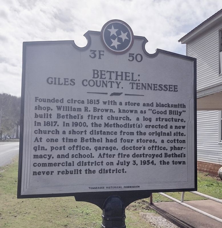
On Turner Road 0 miles north of Alsup Road, on the left when traveling north.
Bethel Masonic Lodge Completed in 1850 as a joint effort of local Masons and Methodists, Bethel's Masonic Lodge has served as a church, school, and community center. The building survived an assault by Federal soldiers in 1862 and a 1954 fire . . . — — Map (db m211056) HM
Near South Rhodes Street north of East Cemetery Street, on the right when traveling north.
Tennessee State Senator 1821 - 1825
Tennessee State Representative 1831 - 1833
U.S. Congressman 1839 - 1845
Governor of Tennessee 1845 - 1847
Postmaster General of the United States 1857 - 1859
Born in Brunswick County, Virginia August . . . — — Map (db m151140) HM
John Benge's Route of the Cherokee Trail of Tears in Alabama, Tennessee, Kentucky, Missouri, Arkansas and Oklahoma, 1838-1839
John Benge led one detachment of approximately 1100 Cherokee with 60 wagons and 600 horses that left from Alabama on . . . — — Map (db m29812) HM
Near South Sam Davis Avenue south of East College Street.
The land that was to become Giles County was claimed as hunting lands by both the Chickasaw and Cherokee Nations. The treaties of Hopewell between the U.S.
Government and the Cherokees (1785) and the Chickasaws (1786) established boundaries between . . . — — Map (db m151150) HM
Near South Rhodes Street north of East Cemetery Street, on the right when traveling north.
Thomas Jones was born in Peron County, North Carolina on December 12, 1816 and moved to Giles County with his family in 1817. Jones received his early education at Wurtemburg Academy and studied at the University of Alabama and University of . . . — — Map (db m75174) HM
On Appleton Road at Blooming Grove Road, on the left when traveling east on Appleton Road.
(Preface): In September 1864, after Union Gen. William T. Sherman defeated Confederate Gen. John Bell Hood at Atlanta, Hood led the Army of Tennessee northwest against Sherman's supply lines. Rather than contest Sherman's "March to the Sea," . . . — — Map (db m82213) HM
Near Cleveland Street west of South Sam Davis Avenue, on the right when traveling west.
James M. McCallum was born in Roberson County, North Carolina in 1806. At an early age his family moved to Giles County where he eventually studied law and opened an active practice in Pulaski.
In 1842 McCallum was elected Clerk and Master of the . . . — — Map (db m151142) HM
Near South Rhodes Street north of East Cemetery Street, on the right when traveling north.
John Calvin Brown was born on Giles County, Tennessee on January 6, 1827. He was one of nine children born to Duncan and Margaret Brown and the brother of Neill S. Brown, Governor of Tennessee (1847-1849). A graduate of Jackson College in Columbia, . . . — — Map (db m75175) HM
On Turner Road just north of Alsup Road, on the right when traveling north.
Dr. Louie Edmundson was the last of a long line of country doctors in the Bethel Community of Giles County, TN. The youngest member of his class, he graduated from the University of Tennessee Medical School in 1912. After serving in the Army Medical . . . — — Map (db m211059) HM
On Wheeler Street/Lambs Ferry Road (Alabama Route 207) south of Lee Street (County Route 66), on the left when traveling south.
(Side 1)
From about 1775 until his death on August 9, 1807, Chickamauga Cherokee Chief Doublehead controlled the Muscle Shoals of the Tennessee River. Two major Indian trails, Sipsie Trail and an east-west trail, intersected in the . . . — — Map (db m99972) HM
Edward Eslick, son of Merritt and Martha Abernaty Eslick, was born near Pulaski on April 10, 1872, attended public schools in Pulaski and Bethel College in Russellville, Kentucky. He studied law under William H. McCallum, was admitted to the bar in . . . — — Map (db m75182) HM
On Interstate 65 at milepost 3.1, 1.8 miles north of Old U.S. 31, on the right when traveling north.
Welcome to Giles County, Tennessee!
Get ready to visit small towns with big stories.
Tennessee Civil War Trails tells riveting stories of battles and leaders, and much more. You'll learn about some of the state's 275,000 enslaved men and . . . — — Map (db m296389) HM
On Fergus Drive 0.1 miles south of Lytle Street, on the left when traveling south.
West of the Nashville Turnpike stands the home of Mary Kate Patterson, a Confederate spy. She assisted Capt. Henry B. Shaw's Coleman's Scouts, a Confederate cavalry unit and spy network that served the Army of Tennessee, from 1862 to 1865. She . . . — — Map (db m146609) HM
On South Sam Davis Avenue south of Cleveland Street, on the right when traveling south.
Sam Davis was born on October 6, 1842 in Smyrna, Tennessee, attended Nashville's Western Military Academy and, like many other young men, left school to join the Confederate Army in 1861. He served as a private in Company I for the 1st Tennessee . . . — — Map (db m151144) HM
On Stadium Street near East College Street (U.S. 64).
Bell's Route of the Cherokee Trail of Tears in Tennessee, Arkansas, and Oklahoma, 1838-1839 Overview
The detachment headed by John Bell differed from the parties under Cherokee Chief John Ross's supervision. Bell's detachment was composed of . . . — — Map (db m29811) HM
On Lee Street at Wheeler Street, on the right when traveling east on Lee Street.
Side A
The settlement of what is now eastern Lauderdale County (known as "Over Elk)" by non-Native Americans commenced by 1807.
Federal land sales were held in Huntsville during the spring of 1818.
Although much of the land was described . . . — — Map (db m281246) HM
On Doctor DB Todd Junior Boulevard north of Albion Street, on the right when traveling south.
Born enslaved in Giles County, R. F. Boyd earned degrees from Meharry's Medical (1882) and Dental (1886) departments. In 1887 he joined the faculty. He ran for a seat in the Tennessee General Assembly in 1892 and was the first African American . . . — — Map (db m286791) HM
On North 1st Street (Tennessee Route 7) at Mitchell Street, on the right when traveling north on North 1st Street.
Though black public education existed in Giles County by 1869, Bridgeforth was the first black high school. Designed by America's first black architectural firm, McKissack and McKissack, which had local roots, and named for black educator J. T. . . . — — Map (db m81559) HM
On East Grisby Street at Childers Street on East Grisby Street.
During the years following the Civil War, Gabriel Moses McKissack (1840-1923) laid the foundation in Giles County for a family building tradition that included the first black architectural firm in the United States, Nashville's McKissack and . . . — — Map (db m75129) HM
On Amos Hamlett Road, on the right when traveling east.
Served under Gen. Andrew Jackson, War of 1812, and participated in the Battle of Horseshoe Bend before receiving a commission as a lieutenant in the Tennessee State Militia. He was the first circuit court clerk in Giles County and served 24 years. . . . — — Map (db m263434) HM
On Columbia Avenue, on the right when traveling south.
Confederate Gen. John C. Brown, a native of Giles County, Tennessee, commanded one of the Southern army’s most formidable divisions. It numbered more than 3,700 soldiers; most hailed from Tennessee, but some called Georgia and South Carolina home. . . . — — Map (db m202808) HM
On Murfreesboro Road (Tennessee Route 96) 0.1 miles east of Ralston Lane, on the right when traveling west.
Walter Aiken Roberts (June 4, 1865 - July 3, 1948), born in Pulaski (Giles County) Tennessee, son of Dr. Joseph Coleman Roberts (11.18.1821 - 3.24.1898) and Sarah Jane Anthony Roberts (1.23.1832 - 12.24.1901).
W.A. Roberts married . . . — — Map (db m161311) HM
Near South Sam Davis Avenue south of East College Street, on the left when traveling south.
The first school in Pulaski/Giles County was chartered by the State of Tennessee on November 23, 1809, just nine days after the passage of the legislation establishing the county. Chartered as the Pulaski Academy, the designated trustees were . . . — — Map (db m151162) HM
The Tennessee and Alabama Railroad connected the "town of Thompson" to Nashville in 1855 and south to Columbia in 1859. Antebellum investors envisioned the railroad, which traveled through some of the most productive lands in Davidson, Williamson, . . . — — Map (db m208537) HM
On Farm to Market Road 1363 0.1 miles east of Front Street (County Highway 315), on the right when traveling west.
A leader in Texas colonization, Alexander Thomson, Jr., was born in St. Matthew's Parish, South Carolina, the only son of Alexander and Lucy (Fontaine) Thomson. He later lived in Georgia before moving to Tennessee. There, in 1830, he became a . . . — — Map (db m210613) HM
On 7th Avenue North north of Union Street, on the left when traveling north.
The tallest office building in Nashville was purchased from American General Life and Accident Insurance Company by the State of Tennessee on January 3, 1994.
It was originally built in 1970 as the National Life Center, home of the National Life . . . — — Map (db m166570) HM
Near Blackburn Hollow Road 0.2 miles south of Clock Creek Road, on the left when traveling south.
Here on February 10, 1867, James Knox Polk Blackburn and Mary “Mackie” McMillan Laird were married on the porch of the Lairdland farm house. She was the daughter of Robert H. and Nancy Mildred Gordon Laird, who owned the thousand-acre farm called . . . — — Map (db m75135) HM
Near South Sam Douglas Avenue south of East College Street.
On November 14. 1809, the Tennessee General Assembly passed an Act which brought Giles County, and its County Seat, Pulaski, into being. The new six hundred square
mile county was formed from land ceded to the State in 1805 by treaty with the . . . — — Map (db m168698) HM
On North First Street (U.S. 31) at Spear Street, on the left when traveling north on North First Street.
From the summit of the prominent high ground ahead of you, White and Black Union soldiers peered over the ramparts of Fort Lilly, keeping an eye on traffic clattering along the "macadamized," or paved, Columbia Turnpike, which followed the . . . — — Map (db m275558) HM
On North First Street (U.S. 31) at Spear Street on North First Street.
During the Civil War, many African-American men escaped slavery to become soldiers in the U.S. Army.
Here in Giles County, the U.S. Army organized the 110th & 111th Regiment U.S. Colored Troops (U.S.C.T.) in late 1863 and early 1864. Most . . . — — Map (db m246051) HM WM
Near Davidson Cemetery Road 2.4 miles west of Texas Highway 108, on the left when traveling west.
Born in Giles County, Tennessee, Joseph Peter Davidson moved to Texas and settled in Palo Pinto County about 1856. Davidson established a trading post near this site. In 1865 he started a ranch in present Eastland County and later helped organize . . . — — Map (db m97807) HM
On Hinkson Avenue at Bennett Street, on the left when traveling north on Hinkson Avenue.
Born in Giles County, Tennessee. Came to Palo Pinto County, 1859, among first settlers in region. Married Jane Allen, July 18, 1860. Served in Co. B, State Troops, during Civil War, protecting frontier. Built this house in mid-1870s. Founded city of . . . — — Map (db m268795) HM
On Sam Davis Road 0.3 miles west of Brookhaven Trail, on the right when traveling west.
In November 1863, while carrying intelligence on Union troop movements, Sam was captured near the Alabama border and jailed in Pulaski, Tennessee.
Interrogated by General Grenville Dodge and others, he was told that if information were not . . . — — Map (db m69102) HM
On Lewisburg Highway (Alternate U.S. 31) just north of Interstate 65, on the left when traveling north.
Giles County
Established 1809: named in honor of Senator William B. Giles of Virginia. One of the strongest advocates for the admission of Tennessee to the Union; he served in U.S. Senate from 1804 to 1815 and was Governor of Virginia, 1827-30. . . . — — Map (db m146816) HM
On South Sam Davis Avenue north of Magazine Road, on the right when traveling north.
Born in Giles County in 1870, J.T. Bridgeforth was educated at A&T State College. In the early 1900's he became interested in securing a county school for black children living outside the city limits of Pulaski and was the prime mover in organizing . . . — — Map (db m151147) HM
On West Cemetery Street at South 3rd Street, on the left when traveling west on West Cemetery Street.
Two Cherokee Detachments traveling on the Trail of Tears crossed Richland Creek in Pulaski just two weeks apart in the autumn of 1838. John
Benge led one group of nearly 1100 Cherokee with 60 wagons and 600 horses through Pulaski, possibly on . . . — — Map (db m151136) HM
On Farm to Market Road 128 at County Road 3500, on the right when traveling east on Farm to Market Road 128.
Early settlers, who came to this area from Giles County, Tenn., founded an academy at this site in 1859, hired fellow-Tennessean Thomas Hart Benton Hockaday (1835-1918) as the first teacher, and named the new school in memory of their southern . . . — — Map (db m311131) HM
On Columbia Pike (U.S. 31) 0.2 miles south of Goose Creek Bypass ( Route 248), on the right when traveling south.
Moving rapidly south through Franklin, Stephen D. Lee's Corps with Chalmers' Cavalry Division attached, took up a delaying position in this area about 1:00 P.M. They beat off attacks by Wood's IV Corps & Wilson's Cavalry. Here, Gen. Lee was wounded; . . . — — Map (db m104201) HM
On Sam Davis Circle at Monument Drive, on the right when traveling south on Sam Davis Circle.
On Nov 20, 1863, scout Sam Davis stopped here while carrying dispatches to Confederate Gen. Braxton Bragg. According to local tradition, he was asleep under a plum tree when two members of the 7th Kansas Cavalry, disguised as Confederates, arrested . . . — — Map (db m75197) HM
On South Rhodes Street near East Cemetery Street, on the right when traveling north.
In 1854, the City Board of Mayor and Aldermen of Pulaski recognized the need for an additional cemetery. The initial purchase of what is now Maplewood Cemetery was approximately seven acres. The first lots were sold in 1855. This original design of . . . — — Map (db m75168) HM
On South Main Street (Farm to Market Road 2268) at College Hill Drive, on the right when traveling north on South Main Street.
Elijah Sterling Clack Robertson was born in Giles County, Tennessee, August 23, 1820. His father, Empresario S.C. Robertson, brought him to Texas to learn Spanish and to help him in his land office translating and copying land grants to Spanish. For . . . — — Map (db m212459) HM
On West Shoal Street at South 6th Street, on the right when traveling east on West Shoal Street.
The first courthouse in Giles County, a rough log cabin, stood in Kirk's Settlement near this spot. Court was held here from February 1810 until December 1811. — — Map (db m151133) HM
Thin black lines indicate changes in relevance. Between each pair of lines entries are ordered geographically but all have the same relevance.
* Inflectional forms of words are their plurals, singulars, and possessives as well as gramatical tenses and similar variations.