By Texmexfla, August 15, 2008
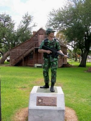
Vietnam Veterans Memorial Marker with Text
RANKED BY RELEVANCE
| On North 14th Street north of Hamilton Street, on the right when traveling north. |
| On Main Street at Duval Street, on the right when traveling west on Main Street. |
| Near Highway 332 east of Hand Lane, on the right when traveling east. |
| On Montgomery Road south of Winner Foster Road, on the right when traveling south. |
| On State Highway 288, on the right when traveling north. |
| Near Farm to Market Road 183 0.7 miles south of U.S. 84, on the left when traveling south. |
| Near Gulf Prairie Road 0.2 miles south of Texas Highway 36, on the left when traveling south. |
| Near Gulf Prairie Road 0.2 miles south of Texas Highway 36, on the left when traveling south. |
| Near Gulf Prairie Road 0.2 miles south of Texas Highway 36, on the left when traveling south. |
| Near Gulf Prairie Road 0.2 miles south of Texas Highway 36, on the left when traveling south. |
| On Brazos River Road east of Highway 2004, on the left when traveling east. |
| On 3rd Street north of D Street, on the right when traveling north. Reported unreadable. |
| On North Market Street at Travis Street on North Market Street. |
| On County Road 316 (Highway 316), on the left when traveling north. |
| Near Main Street (County Route 703) 0.1 miles south of Austin Street (County Road 300E), on the right when traveling north. |
| On Richey Street at Shaw Avenue, on the right when traveling north on Richey Street. |
| Near West 11th Street at Congress Avenue, on the right when traveling east. |
| On N. Brooks Street (State Highway 36) at W. Smith Street, on the right when traveling south on N. Brooks Street. |
| Near 2nd Street at Farm to Market Road 1458. |
| On Salado Creek Greenway west of Noblewood Drive. |
| On CR-319, on the right when traveling south. |
| Near Quintana Street east of North Brazosport Boulevard, on the right when traveling east. |
| On West Brazos Street (State Highway 35) at Brown Street, on the left when traveling west on West Brazos Street. |
| Near East 26th Street at North Washington Avenue, on the right when traveling west. |
| On East Main Street (State Road 25) at N Center St (State Road 79), on the right when traveling west on East Main Street. |
| On North Velasco Street, on the right when traveling north. |
| Near Cemetery Road at Shanks Road, on the right when traveling east. |
| On East Locust Street, on the left when traveling east. |
| Near County Road 373 west of Farm to Market Road 521. |
| On South 16th Street 0.1 miles north of East Jackson Street, on the right when traveling north. |
| On State Highway 36 0.5 miles south of County Road 4, on the right when traveling north. |
| Near Boonville Road (Farm to Market Road 158) 0.1 miles east of Austins Colony Parkway. |
| Near North Main Street (U.S. 87) at West Red River Street. |
| Near East Cedar Street at North Velasco Street (Business State Highway 288). |
| On North Velasco Street, on the right when traveling north. |
| Near East Jackson Street east of South 16th Street, on the right when traveling east. |
| On North Avenue O west of Skinner Street when traveling west. |
| On North Getty Street (U.S. 83) north of East Nopal Street, on the right when traveling north. |
| On Farm to Market Road 1094 at Swearingen Road, on the right when traveling west on Highway 1094. |
| On North Velasco Street, on the right. |
| On North Grand Boulevard at East Broadway Street (Farm to Market Road 518), on the right when traveling north on North Grand Boulevard. |
| On South Wynden Drive 0.2 miles east of South Post Oak Lane, on the right when traveling east. |
| Near State Highway 332 0.1 miles County Highway 257. Reported missing. |
Thin black lines indicate changes in relevance. Between each pair of lines entries are ordered geographically but all have the same relevance.* Inflectional forms of words are their plurals, singulars, and possessives as well as gramatical tenses and similar variations.
Nov. 12, 2026
