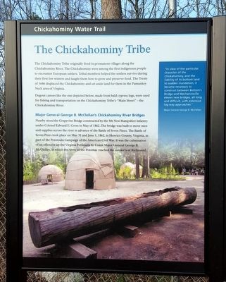
By Bernard Fisher, March 7, 2016
Chickahominy Water Trail (left panel)
RANKED BY RELEVANCE
| On North Airport Drive (Virginia Route 156) 0.3 miles north of Old Hanover Road, on the left when traveling north. |
| On Mechanicsville Turnpike (U.S. 360) 0.7 miles west of Elm Drive, on the right when traveling east. |
| On East Williamsburg Road (U.S. 60) 0.1 miles east of White Oak Road, on the right when traveling east. Reported missing. |
| On Mountain Road west of Jessie Chavis Drive, on the right when traveling west. |
| Near North 16th Street north of East Broad Street (U.S. 250), on the right when traveling south. |
| Near East Marshall Street at North 16th Street, on the left when traveling west. Reported permanently removed. |
| Near New Market Road (Virginia Route 5) at Interstate 295, on the left when traveling east. Reported permanently removed. |
| Near Prince Henry Drive near East Parham Road. |
| On Messer Road 0.1 miles north of Library Road, on the right when traveling north. |
| On Brook Road (U.S. 1) 0.1 miles north of Brook Run Drive, on the right when traveling north. |
| On Anderson Drive west of Jordan Point Road, on the left when traveling west. |
| On Mountain Road at Jessie Chavis Drive, on the right when traveling west on Mountain Road. Reported permanently removed. |
| On New Market Road (Virginia Route 5) 0.2 miles west of Willis Church Road ( Route 156), on the right when traveling east. |
| Near Clarendon Road near Mylan Road. |
| On New Market Road (Virginia Route 5) at New Market Heights Lane, on the left when traveling east on New Market Road. |
| Near New Market Road (Virginia Route 5) west of Doran Road, on the right when traveling west. |
| Near Ararat Highway (Virginia Route 773) 0.3 miles west of State Line Road, on the right when traveling west. |
| Near Park Street near Bloomingdale Avenue. |
| On West Leigh Street west of Kinney Street, on the right when traveling west. |
| On Cary Street Road (Virginia Route 147) at South Wilton Road, on the right when traveling east on Cary Street Road. |
| Near Fort Darling Road 0.5 miles north of Bellwood Road. |
| On East Hundred Road (Virginia Route 10) at Point of Rocks Road, on the right on East Hundred Road. |
| Near Meadow Farm Drive north of Mountain Road, on the left when traveling south. |
| On Chatsworth Road 0.1 miles north of New Market Road ( Route 5), on the right when traveling north. |
| On Hungary Road at Old Staples Mill Road, on the right when traveling west on Hungary Road. |
| Near Hilliard Road (Virginia Route 161) 0.2 miles east of Tanya Avenue. |
| On Longbridge Road 0.1 miles north of Carters Mill Road, on the right when traveling north. |
| On Anderson Highway (U.S. 60) at Ridge Road, on the right when traveling west on Anderson Highway. |
| On Chamberlayne Avenue (U.S. 301) 0.3 miles north of Interstate 95, on the right when traveling north. |
| Near Hampton Street at Dakota Avenue, on the right when traveling south. |
| On East Grace Street near North 18th Street, on the left when traveling east. |
| On South 14th Street (U.S. 360) 0.2 miles south of East Byrd Street, on the right when traveling south. |
| On North 9th Street at Capitol Square, on the right when traveling north on North 9th Street. |
| On Capitol Square east of North 9th Street, on the right when traveling east. |
| On Three Chopt Road at Hanover Avenue, on the right when traveling south on Three Chopt Road. |
| On Maidens Road (U.S. 522) at Maidens Loop, on the right when traveling south on Maidens Road. |
| On Pouncey Tract Road (Virginia Route 271) 0.2 miles north of Countryview Drive, on the right when traveling north. |
| On Mountain Road 0.3 miles west of Bluebell Drive, on the right when traveling west. |
| Near Dorey Park Drive 0.3 miles south of Darbytown Road, on the left when traveling south. |
| On Ridge Road at Ziontown Road, on the left when traveling west on Ridge Road. |
| On New Market Road (Virginia Route 5) 1 mile east of Interstate 295, on the right when traveling east. |
| On Glenburnie Road north of Patterson Avenue ( Route 6), on the right when traveling north. |
| On Chickies Hill Road south of Cedar Terrace, on the right when traveling north. |
| On Waterfront Drive east of Dunston Point Parkway, on the right when traveling east. |
| On New Market Road (Virginia Route 5) at Sweeney Landing Road, on the right when traveling east on New Market Road. |
| Near Ararat Highway (Virginia Route 773) 0.3 miles west of State Line Road, on the right when traveling west. |
| On Broad Street (U.S. 250) 0 miles east of Interstate 95, on the left when traveling east. Reported permanently removed. |
| Near The Glebe Lane (Virginia Route 615) at Southall Plantation Lane, on the right when traveling west. |
| Near Walney Road. Reported missing. |
| On Telegraph Road 0.2 miles south of Virginia Center Parkway, on the right when traveling south. |
| On Chickies Hill Road south of Cedar Terrace, on the right when traveling north. |
| On West Broad Street (U.S. 250) east of Wilkes Ridge Parkway, on the right when traveling east. |
| Near Verdon Road (Virginia Route 684) 0.2 miles west of New Market Mill Road ( Route 685), on the right when traveling west. |
| Near Mountain Road at Courtney Road. |
| Near North Woolridge Road 0.3 miles south of Walton Park Road. |
| Near Kingsland Road 0.3 miles west of Deep Bottom Road, on the right when traveling west. |
| Near Ararat Highway (Virginia Route 773) 0.3 miles west of State Line Road, on the right when traveling west. |
Thin black lines indicate changes in relevance. Between each pair of lines entries are ordered geographically but all have the same relevance.* Inflectional forms of words are their plurals, singulars, and possessives as well as gramatical tenses and similar variations.
Nov. 13, 2026
