40 entries match your criteria.
Entries Containing All of the Phrases «muskingum county» AND «ohio»
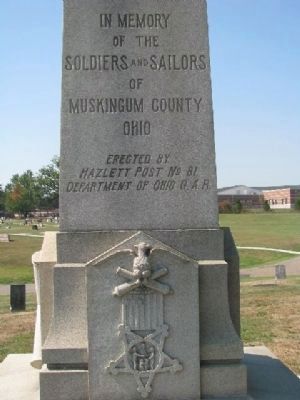
By William Fischer, Jr., September 21, 2008
Soldiers and Sailors Monument
RANKED BY RELEVANCE
1 ► Ohio, Muskingum County, Zanesville — G.A.R. Soldiers and Sailors Monument — Muskingum County, Ohio —  |
| On Pershing Road, on the left when traveling west. | |||
| 2 ► Ohio, Muskingum County, Norwich — 1-60 — Salt Creek Bridge/Timber Covered Bridges — |
| On Arch Hill Road at Murphy Hill Road, on the right when traveling east on Arch Hill Road. | |||
| 3 ► Ohio, Muskingum County, Zanesville — 14-60 — Architect Cass Gilbert — |
| On 4th Street at Market Street, on the right when traveling north on 4th Street. | |||
| 4 ► Ohio, Muskingum County, Zanesville — 7-60 — Second Capital of Ohio — |
| On Main Street (U.S. 40) east of 4th Street, on the left when traveling east. | |||
| 5 ► Ohio, Muskingum County, Zanesville — 11-66 — The Stone Academy — |
| On Putnam Avenue (Ohio Route 93) north of Jefferson Street, on the left when traveling south. | |||
| 6 ► Ohio, Muskingum County, Zanesville — 1836 — |
| Near Putnam Avenue north of Jefferson Street. | |||
| 7 ► Ohio, Muskingum County, Zanesville — 18-60 — Anti-Slavery Tensions in Muskingum County — |
| Near Jefferson Street at Putnam Avenue (U.S. 22). | |||
| 8 ► Ohio, Muskingum County, Fultonham — 10-60 — Birthplace of Thomas A. Hendricks — |
| On Old Town Road 0.6 miles east of Cemetery Road. | |||
| 9 ► Ohio, Muskingum County, Gaysport — Gaysport Bridge — |
| On North Street (Ohio Route 66) near West River Road, on the right when traveling west. | |||
| 10 ► Ohio, Muskingum County, Zanesville — Veterans Memorial — |
| On Madison Street east of Putnam Avenue (U.S. 22), on the left when traveling east. | |||
| 11 ► Ohio, Coshocton County, Roscoe Village — 7-16 — Underground Railroad Agents in Coshocton County / Muskingum River Underground Railroad Corridor — |
| On County Road 495 at State Route 16, on the right when traveling west on County Road 495. | |||
| 12 ► Ohio, Muskingum County, Norwich, Perry Township — Johnson's Mill/Salt Creek Covered Bridge — |
| On Arch Hill Road (County Road 82) at Murphy Hill Road, on the right when traveling east on Arch Hill Road. | |||
| 13 ► Ohio, Washington County, Belpre — 22-84 — Underground Railroad Crossings / Near Border War — |
| On Ridge Street at Locust Street, on the left when traveling west on Ridge Street. | |||
| 14 ► Ohio, Muskingum County, Zanesville — 5-60 — Y-Bridge — 1902 |
| On West Main Street (Historic National Road) (U.S. 40), on the right when traveling east. Reported missing. | |||
| 15 ► Ohio, Muskingum County, Zanesville — 3-60 — Y-Bridge — 1902 — |
| On Linden Avenue north of Main Street (U.S. 40), on the right when traveling south. | |||
| 16 ► Ohio, Muskingum County, Zanesville — 4-60 — Y-Bridge — 1902 — |
| On Main Street (U.S. 40), on the right when traveling south. | |||
| 17 ► Ohio, Trumbull County, Warren — Leicester King / The Underground Railroad on the Warren-Ashtabula Turnpike — Warren, Ohio (Trumbull County) — Historic Underground Railroad Site — |
| On Mahoning Avenue 0.1 miles north of High Street NW, on the right when traveling south. | |||
| 18 ► Ohio, Licking County, Thornville — Eagles Nest — The Historic National Road in Ohio — |
| On Old National Road (U.S. 40), on the left when traveling east. | |||
| 19 ► Ohio, Franklin County, Columbus, Fairgrounds — Flint: Ohio's State Gemstone — Specimen: Vanport flint — |
| On East 11th Avenue at Essex Avenue, on the right when traveling north on East 11th Avenue. | |||
| 20 ► Ohio, Muskingum County, Zanesville — Zanesville and Muskingum County Artwall — |
| On 5th Street at Shinnick Street, on the left when traveling south on 5th Street. | |||
| 21 ► Ohio, Muskingum County, Zanesville — Zanesville Underground Railroad — |
| On Muskingum Avenue west of Putnam Avenue ( Route 93), on the right when traveling west. | |||
| 22 ► Ohio, Pickaway County, Westfall, Wayne Township — Ohio-Erie Canal — Canal Park — Pickaway County Park District — |
| On Canal Road (County Route 100), on the right when traveling north. | |||
| 23 ► Ohio, Muskingum County, Cumberland — 17-60 — The Lett Settlement — |
| Near International Road (Local Route 216) east of Big Muskie Drive ( Route 284). | |||
| 24 ► Ohio, Cuyahoga County, Moreland Hills — Making a Homestead — |
| Near S.O.M. Center Road, on the right when traveling south. | |||
| 25 ► Ohio, Franklin County, Columbus, Uptown District — The Refugee Tract — |
| On Broad Street (U.S. 40) at Front Street, on the right when traveling west on Broad Street. | |||
| 26 ► Ohio, Guernsey County, Cambridge — The Founders of Cambridge — |
| On Southgate Parkway (Ohio Route 209) at Turner Avenue, on the right when traveling north on Southgate Parkway. | |||
| 27 ► Ohio, Muskingum County, Philo — 8-60 — The Muskingum River Flows North — |
| Near Bridge Street. | |||
| 28 ► Ohio, Muskingum County, Zanesville — 1863 — |
| Near Putnam Avenue north of Jefferson Street, on the right when traveling north. | |||
| 29 ► Ohio, Clark County, Springfield — Mile Markers — The Historic National Road in Ohio — |
| On West Main Street west of South Isabella Street, on the left when traveling west. | |||
| 30 ► Ohio, Belmont County, Brookside — Mile Markers — The Historic National Road in Ohio — America's Byways — |
| On National Road (U.S. 40) at Patterson Road, on the right when traveling east on National Road. | |||
| 31 ► Ohio, Pickaway County, Walnut — Blackburn / Wesner Bridge — |
| Near Covered Bridge Trail. | |||
| 32 ► Ohio, Morgan County, Stockport — 19- 58 — Underground Railroad — / Underground Railroad in Morgan County — |
| On Broadway Street (Route 266), on the right when traveling east. | |||
| 33 ► Ohio, Pickaway County, Walnut — Blackburn / Wesner Bridge — |
| Near Marcy Road (County Route 89) 0.4 miles west of Winchester Southern Road ( Route 674), on the right when traveling west. | |||
| 34 ► Ohio, Fairfield County, Pickerington — Union Veteran Legion Sherman Monument — 1861 - 1865 — |
| Near Hill Road North. | |||
| 35 ► Ohio, Muskingum County, Zanesville — 1834 — |
| Near Putnam Avenue north of Jefferson Street. | |||
| 36 ► Ohio, Muskingum County, Zanesville — Nelson T. Gant House — Historic Underground Railroad Site — |
| On West Main Street (U.S. 40) west of Oakland Avenue, on the right when traveling west. | |||
| 37 ► Ohio, Muskingum County, Zanesville — Putnam Presbyterian Church — Circa 1835 — |
| On Woodlawn Avenue at Jefferson Street, on the right when traveling south on Woodlawn Avenue. | |||
| 38 ► Ohio, Muskingum County, Zanesville — The History of Zanesville |
| On Main Street (U.S. 40) west of North 5th Street, on the right when traveling west. Reported permanently removed. | |||
| 39 ► Ohio, Muskingum County, Zanesville — World War II/Korean War Memorial — |
| On Main Street (U.S. 40) at 5th Street, on the right when traveling west on Main Street. | |||
| 40 ► Ohio, Muskingum County, Zanesville — Zanesville — The Historic National Road in Ohio — |
| On Old National Road (U.S. 40), on the right when traveling west on Old National Road. | |||
Thin black lines indicate changes in relevance. Between each pair of lines entries are ordered geographically but all have the same relevance.
* Inflectional forms of words are their plurals, singulars, and possessives as well as gramatical tenses and similar variations.
Nov. 12, 2026