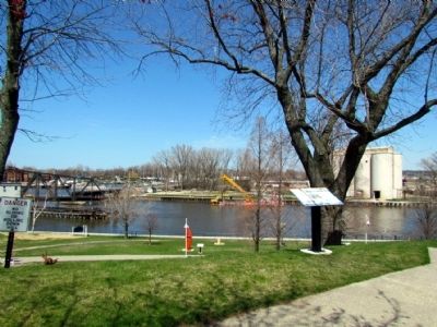
On Lake Boulevard at Port Street, on the left when traveling north on Lake Boulevard.
The meeting of river and lake provided a natural setting for a harbor at St. Joseph. Human engineering would ultimately develop the port into one of the busiest on Lake Michigan.
In the 1830s, at the urging of local merchants, the U.S. Corps of . . . — — Map (db m68195) HM
On Lake Boulevard at Broad St, on the right when traveling south on Lake Boulevard.
On July 5, 1897 with great pride and effort the A.W. Chapman Post of the Grand Army of the Republic dedicated this gun and grounds to the memories of those who fought in the Civil War in defense of the flag. This 11 inch bore Dahlgren was built in . . . — — Map (db m64869) HM WM
On Lake Boulevard at Ship Street, on the right when traveling south on Lake Boulevard.
Here in November 1679, on the Miami River, as the St. Joseph was then called, La Salle, the French explorer built a fort as a base for his western explorations. Here he awaited the Griffin, the upper lakes' first ship. When the ill-fated . . . — — Map (db m64837) HM
On Lake Street close to Market Street, on the right when traveling south.
At the turn of the 20th century when the great migration from Europe was taking place, many Germans from colonies located in Russia, and other areas of Europe, left their homes and some of them settled in Southwest Michigan. The original houses . . . — — Map (db m307021) HM
This Glacial Boulder found in the bed of the St. Joseph River was erected in 1902 by the Algonquin Chapter Daughters - American Revolution to commemorate the landing of Rene Robert Cavelier Sieur de La Salle and the building on this point. Fort . . . — — Map (db m43962) HM
On Lake Boulevard north of Elm Street, on the left when traveling north.
The Great Lakes region is one of the nation's most important centers of maritime commerce. Lighthouses helped mariners navigate these vast inland seas. In 1832, the U.S. Government built the first lights on Lake Michigan at two of its busiest . . . — — Map (db m68176) HM
On Lake Boulevard north of Market Street, on the left when traveling north.
The north pier lighthouses, built in 1907, guide ships to this port. The inner light replaced a smaller, wooden lighthouse in use since 1847. The north pier was then extended and the outer light tower was added, allowing mariners to find the harbor . . . — — Map (db m68152) HM
On State Street at Sutherland Street, on the left when traveling south on State Street.
During the late nineteenth and early twentieth centuries, local river captains, mill owners, merchants and other professionals built homes in this neighborhood. Over one hundred of their homes remain. They exemplify popular architectural styles . . . — — Map (db m64856) HM
On Lake Street 0.1 miles north of Park Street, on the right when traveling south.
On October 11 and 22, 1898, Augustus M. Herring flew a powered airplane on Silver Beach near this spot. Herring began flying experiments in the 1880's and in 1894-95 built model gliders for aviation researchers Octave Chanute and Samuel P. . . . — — Map (db m258204) HM
Near Water Street east of State Street, on the left when traveling east.
Whether paddling a canoe, riding a riverboat, or sailing a yacht, pleasure boating has always been a favorite St. Joseph activity. Recreational boating has remained popular due to well-stocked fishing grounds and accessible private and city marinas. . . . — — Map (db m68216) HM
On Water Street east of State Street, on the left when traveling east.
With a ready supply of lumber and a thriving port, St. Joseph and Benton Harbor offered a natural setting for shipbuilding. As early as the 1830s, sailing and steam-powered vessels were built here for lake and river navigation.
Shipbuilders . . . — — Map (db m68204) HM
On Lake Boulevard north of Elm Street, on the left when traveling north.
From its opening in 1891, the Silver Beach Amusement Park made St. Joseph a prime destination for tourists. Huge crowds enjoyed the park's many attractions, which included a carousel, roller rink, indoor swimming pool, bowling alley, beer garden, . . . — — Map (db m68177) HM
On Broad Street 0.1 miles west of Lake Street, on the right when traveling west.
In 1891 Logan Drake and Louis D. Wallace founded the Silver Beach Amusement Co. on this beach. Local concessionaires sold novelties to draw tourists and in 1902 the company built a bathhouse, roller skating rink and dance pavilion. During the . . . — — Map (db m258203) HM
On Lake Boulevard north of Market Street, on the left when traveling north.
Two historic waterways, Lake Michigan and the St. Joseph River, meet here. Opportunities for maritime trade, transportation, industry and recreation led to the founding of St. Joseph and Benton Harbor. Explore the Maritime Heritage Trail and . . . — — Map (db m68151) HM
On Water Street east of State Street, on the left when traveling east.
Two historic waterways, Lake Michigan and the St. Joseph River, meet here. Opportunities for maritime trade, transportation, industry and recreation led to the founding of St. Joseph and Benton Harbor. Explore the Maritime Heritage Trail and . . . — — Map (db m68203) HM
On Water Street west of State Street, on the right when traveling west.
St. Joseph's swing bridge allows passage for both maritime and railroad commerce. An alternative to a drawbridge, the swing bridge pivots open for vessels to pass and closes for trains to cross. St. Joseph's swing bridge is typically left open until . . . — — Map (db m68223) HM
On Port Street at Lake Boulevard, on the right when traveling west on Port Street.
In Memoriam
Erected to commemorate
the bravery of those who
heroically gave up their
lives in the performance
of duty at the burning of
York's Opera House,
Benton Harbor, Michigan,
Sunday, September 8, 1896.
Edward H. Gange . . . — — Map (db m64893) HM
On Water Street west of State Street, on the right when traveling west.
A U.S. lighthouse supply depot was built at St. Joseph in 1893. For a quarter century, this depot equipped all of Lake Michigan's lights with materials ranging from lenses to lamp oil. Operations of the St. Joseph Depot were transferred to Milwaukee . . . — — Map (db m68218) HM
On Lake Boulevard at Pleasant Street, on the left when traveling north on Lake Boulevard.
The waters off St. Joseph and Benton Harbor have long served as an active and frequently dangerous avenue of maritime trade. High winds and hazardous waves made shipwrecks a common occurrence.
To assist mariners, a U.S. Life Saving Service . . . — — Map (db m68194) HM
On Red Arrow Highway (Business Interstate 94) 0.5 miles north of Exit 23 (Interstate 94), on the right when traveling north.
This early twentieth-century bungalow was
originally the home of infamous gangster
Fred “Killer” Burke. Burke was not only
involved in the St. Valentine’s Day Massacre
in Chicago, but also the murder of a beloved
local policeman, Charles . . . — — Map (db m307558) HM
On East Central Street, on the right when traveling north.
The Apple Cider Century is an annual
one-day bicycle tour of the scenic backroads
surrounding Three Oaks bringing together families
and cycling enthusiasts from across the country and
around the world.
Organized by the Three Oaks Spokes Club, . . . — — Map (db m264890) HM
This cannon, captured in the Spanish-American War by Admiral Dewey, was presented to Three Oaks when its citizens raised $1,400 for a memorial to the men of the battleship Maine. This was the largest contribution, per capita, of any community in the . . . — — Map (db m1603) HM
This is not an ordinary wood," says Bill Burger, curator emeritus of The Field Museum's botany department, who was first drawn to Warren Woods some 30 years ago by "a botanist's desire to see virgin forest." Indeed, it is . . . — — Map (db m278916) HM
On North Elm Street, on the right when traveling north.
J.W. Spinning operated a novelty and dry goods store here in the late 1800's and early 1900's. In April of 1946 Clayton and Wilde DeWaters purchased the business from Frances Goble and in the early 1950's bought the building. They soon expanded it . . . — — Map (db m288838) HM
On South Elm Street, on the right when traveling north.
1800s
Long before Three Oaks existed, this land was home to native peoples. Michiana was rich in game, fowl, fish, and wild rice, and the soil was good for growing vegetable crops like corn, beans, and squash.
Ojibwe, Odawa, and Miami . . . — — Map (db m279863) HM
On North Elm Street, on the right when traveling north.
William Bremer built this two story building in the parking lot to the immediate south (right as you are reading this) in 1891. He operated a grocery store, meat market and saloon on the ground floor and an opera house on the second floor. E.K. . . . — — Map (db m288793) HM
On Lakeshore Road at Apple Avenue, on the right when traveling south on Lakeshore Road.
Built in 1924 by Louis and Lena Gordon, and expanded four years later, Gordon Beach Inn was the centerpiece of the Jewish resort subdivision of the same name. The Gordons operated the inn for a decade before losing it during the Great Depression. . . . — — Map (db m64829) HM
On South Matteson Street north of East Corey Street, on the right when traveling north.
Built in 1970, in just 14 hours, Bronson's City Hall is made of reinforced fiberglass plastic. The building won the State of Michigan Product of the Year award, presented by the Michigan State Chamber of Commerce.
Bronson sold its old City Hall . . . — — Map (db m159710) HM
On North Matteson Road at West Chicago Street (U.S. 12), on the left when traveling north on North Matteson Road.
In honor of the men from the Bronson High School who made the Supreme
Sacrifice in the Great
1917 - World War - 1919
Claude William Alderman
Edwin Riley Bennett
Charles Morris Cockle
Presented by the class of 1920
This . . . — — Map (db m165468) WM
On North Matteson Street at York Street, on the left when traveling north on North Matteson Street.
The Bronson library originated in the early 1880s as the Ladies Library Association. In 1888 the township assumed ownership. Built with funds donated by steel tycoon Andrew Carnegie, the Classical Revival Bronson Public Library opened on May 23, . . . — — Map (db m64550) HM
On North Matteson Street (U.S. 12) north of West Chicago Street (Highway 12), on the left when traveling north.
In tribute to all those courageous men and women who have served and are now serving their country that our freedom should not be forever lost and to those who made the supreme sacrifice. This memorial is sincerely and humbly dedicated. — — Map (db m165470) WM
On North Matteson Road (U.S. 12) north of West Chicago Street (U.S. 12), on the left when traveling north.
Bronson was named after Jabez B. Bronson, who was
the first settler to the area, moving here from Ohio
in 1828. He became the first postmaster in 1830,
calling it Bronson's Prairie. It was Incorporated as a
village in 1866. The name was . . . — — Map (db m165471) HM
On W. Chicago Street (U.S. 12) at N. Matteson Road, on the left when traveling east on W. Chicago Street.
He married Frances Elizabeth Dahn of Sturgis in 1935. They lived in Coldwater and had one daughter, Diane.
During the War Years of WWII Mr. Davison supported the war effort by hosting War Bond dinners. One article
reports that he was responsible . . . — — Map (db m165467) HM
On N. Matteson Road at York Street, on the left when traveling north on N. Matteson Road.
This tree was planted
in 1921
by the Woman's Club
of Bronson in honor of
those from our town
who served our country
in the World War.
Re Planted
Nov. 1997 — — Map (db m165411) WM
On West Chicago Road (U.S. 12) 0.4 miles east of Prairie River Road, on the right when traveling west.
One of the great routes for the pioneers coming west was the Chicago Road. The survey of the road began at Detroit in 1825 and followed closely the Sauk Trail which Indians had marked and traveled for centuries before the coming of the white man. . . . — — Map (db m64549) HM
On W. Chicago Street (U.S. 12), on the right when traveling east.
Is designed for Coldwater and all of Branch County to
fulfill a threefold purpose: to honor, to commemorate
and to serve as a lasting tribute for all those who served
in war, who were killed in action, who died from their
battle wounds or . . . — — Map (db m165452) WM
On Willow Lane at West Chicago Street, on the left when traveling north on Willow Lane.
Allen Tibbets an itinerant Methodist minister
who preached the gospel for 15 years came to this
prairie in 1830 and purchased 80 acres in section 22
with the help of Joseph Hatchett who owned the adjoining
land in 1831 he plotted a village which . . . — — Map (db m165462) HM
On Airport Drive at Airview Drive, on the right when traveling east on Airport Drive.
The plat for the Village of Branch was signed the 16th day of March 1832 in Detroit by Sol. Sibley a Supreme Court judge for the Territory of Michigan. The proprietors Elisha Warren, De Gormo Jones, and Ebenezer S. Sibley also signed. . . . — — Map (db m66771) HM
On Division Street at East Pearl Street, on the right when traveling north on Division Street.
Branch County
Branch County, named for John Branch, President Andrew Jackson's secretary of the navy, was one of thirteen counties established by the Michigan Territorial Legislature in 1829. The village of Branch, located three miles . . . — — Map (db m66759) HM
On East Chicago Street (U.S. 12) at Marshall Street (Old U.S. 27), on the left when traveling east on East Chicago Street.
A tribute to the men of Branch County who in the spirit of loyalty served their country in the World War and in loving memory of those inscribed below who made the supreme sacrifice.
Adams, George R. • Alderman, Claude W. • Berger, Harold • . . . — — Map (db m66692) WM
On West Chicago Street (U.S. 12) at Marshall Street (Old U.S. 27), on the right when traveling west on West Chicago Street.
Memorial
To honor those valiant men and women of World War II who gave their lives for God and Country
Paul Keller • Richard Symons • Donald Perry • Rollin Johnson • Marion Nutt • Donald Russell • Sidney Palmateer • Harold Van Patten • . . . — — Map (db m66769) WM
On East Chicago Street (U.S. 12) at Marshall Street (Old U.S. 27), on the left when traveling east on East Chicago Street.
The Michigan National Guard Armory was dedicated in 1917 and was the major information and gathering facility for Branch County's Military, Company A-32.
These guns, known as the Maxim-Nordenfeldt Automatics, are anti-aircraft weapons, and they . . . — — Map (db m66694) WM
On East Chicago Street (U.S. 12) at Division Street (Old U.S. 27), on the right when traveling east on East Chicago Street.
(Front Panel)
To the memory
of the
soldier dead
Erected by Butterworth
Woman's Relief Corps No. 31
and the Citizens of
Coldwater
Dec 1906
(Right Side Panel)
To the memory
of the
soldiers of the . . . — — Map (db m66718) WM
On Marshall Street (Old U.S. 27) at Church Street, on the right when traveling north on Marshall Street.
Organized in 1837, the same year that Coldwater became a village, the local Presbyterian society held services in various quarters until 1844 when it erected its first church. It completed the present Romanesque Revival-style brick church in 1869 at . . . — — Map (db m122218) HM
Near East Chicago Street (U.S. 12) at Marshall Street (Old U.S. 27), on the left when traveling east.
Born at Rochester, Michigan, June 23, 1840
Died at San Jose, California, December 28, 1912
Civil War 1861-1863
Private Duryees Zouaves, 5th N.Y. Inf.
Michigan National Guard
Enlisted 1876
Commissioned Capt. Co. A, 2nd Regt. . . . — — Map (db m66691) HM WM
On Division Street (Old U.S. 27) at East Washington Street, on the right when traveling north on Division Street.
On this site lived Cyrus Gray Luce, twenty-seventh Governor of Michigan. Born in Ohio in 1824, he moved to Branch County about 1849. He soon became involved in township, local and state politics, serving on the Board of Agriculture, in the . . . — — Map (db m66760) HM
On East Chicago Street (U.S. 12) at North Hudson Street, on the right when traveling west on East Chicago Street.
H.C. Lewis Art Gallery
Businessman Henry Clay Lewis and his wife, Alma, built the original part of this structure in 1869 to house their extensive art collection and make it available to the public. The Italianate building complimented the . . . — — Map (db m103503) HM
Near Airport Drive at Airview Drive, on the right when traveling east.
(Front Side)
According to a long-standing Quimby family tradition, early aviatrix Harriet Quimby was born in the Coldwater area on May 1, 1875, to Ursula (Cook) and William Quimby. She spent her childhood in Arcadia, Michigan, and Arroyo . . . — — Map (db m67528) HM
On S. Hanchett Street, on the left when traveling north.
The CHS Interact Club began a community service project in 2019 to commission a downtown mural for Coldwater. The club members chose the design made by Abby Licht, a 2018 CHS graduate and former Interact Club member. We have had tremendous support . . . — — Map (db m198604) HM
On West Chicago Street (U.S. 12) 0.5 miles east of River Road, on the right when traveling east.
Leroy J. Dove
Army Pfc E-3
1930 - Est 7/27/50
Robert G. Burch
Army Pfc E-3
1931 - 9/14/50
Raymond Rogers
Army Sgt E-7
1929 - Est 12/15/50
Marion M. Eck
Army Sgt E-5
1923 - 9/1/50
William W. Rose
USAF A1C. E-3
1930 - 11/14/50 . . . — — Map (db m165456) WM
On East Chicago Street (U.S. 12) at Marshall Street (Old U.S. 27), on the left when traveling east on East Chicago Street.
This is one of the six ten pounder Parrott guns sent to Loomis Battery by General McClellan at Rich Mountain, West Virginia, to replace the old six pounder brass gun originally supplied the battery, and was in service in West Virginia from July 1st . . . — — Map (db m66690) HM
On East Chicago Street (U.S. 12) at Division Street (Old U.S. 27), on the right when traveling east on East Chicago Street.
The first formal step toward the founding of a state library association was taken by Mary A. Eddy, of the Coldwater Free Public Library, in a letter to Henry M. Utley of the Detroit Public Library on January 13, 1891. They had discussed this matter . . . — — Map (db m66717) HM
Near East Chicago Street (U.S. 12) at Marshall Street (Old U.S. 27), on the left when traveling east.
Hero of the Civil War, a beautiful, powerfully built draft horse, was the only survivor of the two hundred horses assigned to the Loomis battery of Michigan, after having been engaged in many battles and skirmishes.
Old Sam was wounded several . . . — — Map (db m66693) HM
On Division Street (Business Interstate 69) at East Chicago Street (U.S. 12), on the left when traveling south on Division Street. Reported missing.
The gardens in the library park have been donated by the family of Richard L. Bettinger in honor of donors who contributed $500 or more to the renovation of the Naomi Davis Home, Branch County's shelterhouse. Individuals and organizations who made . . . — — Map (db m104982) HM
The bald eagle was chosen as the emblem of the United States of America
when the Great Seal of the United States was adopted on June 20, 1782.
To the nation's founders, the eagle represented freedom as well as
supreme power and authority.
. . . — — Map (db m198603) HM
Near Marshall Road 0.3 miles north of State Street, on the right when traveling north.
State Public School at Coldwater
In 1871 the Michigan legislature authorized the building of a special state public school to furnish temporary support and instruction for dependent and neglected children between the ages of four and . . . — — Map (db m68976) HM
On East Chicago Street (U.S. 12) at Marshall Street (Old U.S. 27), on the left when traveling east on East Chicago Street.
Potawatomie Indians ceded Coldwater Prairie to the United States in 1827. The Indians called it “Chuck-sew-ya-bish,” meaning “cold spring water.” Coldwater is located at the junction of Old Sauk and Fort Wayne Indian trails. . . . — — Map (db m65858) HM
On South Hanchett Street, on the left when traveling north.
This glass preserves a section of original mortar which included hand-painted white stripes, a once-fashionable technique called penciling. — — Map (db m198608) HM
On South Hanchett Street, on the left when traveling north.
Branch County's showplace for the performing arts since 1882. Tibbits Opera House served as the Performing Arts Center between Chicago and Detroit until 1920. The renovated opera house continues to serve the cultural needs of the community.
. . . — — Map (db m198605) HM
On West Chicago Street (U.S. 12) at Willow Lane, on the right when traveling west on West Chicago Street.
To Commemorate
the memory of
The Pioneers
and
First Surveyors
who by perilous efforts
over the Indian trail
made possible
the magnificent highway
M-23
Marked by
The Coldwater Chapter
Daughters of American . . . — — Map (db m241051) HM
On South Jefferson Street at East Pearl Street, on the right when traveling north on South Jefferson Street.
This impressive Second Empire style home with mansard roof was constructed in 1875 for Jay M. Chandler (1850-1884) and his young bride Frances. On this site from 1847-1871 had stood the Parrish flouring mill. Jay, the fourth son of locally prominent . . . — — Map (db m66761) HM
On West Chicago Street (U.S. 12) 0.5 miles east of River Road, on the right when traveling east.
George P. Adams Army Ssg E-6 1897 - 10/23/1918
Edwin R. Bennett Army Pfc E-3 1889 - 10/11/1918
Joe W. Bohacz Army Cpl E-4 1897 - 8/1/1918
Charles R. Burr Army Cpl E-4 1898 - 5/28/1919
Roy B. Cass Navy Pos E-4 1895 - 10/15/1918
Charles M . . . — — Map (db m165459) WM
On West Chicago Street (U.S. 12), on the right when traveling east.
George I. Scriber
Army Private E-2
1913 - 4/16/45
Albert F. McClughen
Army Private E-2
1925 - 1/1/45
Roy L. Matheson
Navy Seaman E-3
1921 - 10/24/44
John E. Seiler
Army Private E-2
1921 - 11/26/44
Charles E. Swihart
Navy P03 . . . — — Map (db m165458) WM
On West Chicago Street (U.S. 12) 0.4 miles east of River Road, on the right when traveling east.
In memoriam to
George W. Parker
1872 ---- 1930
Organizer of
The Michigan Association of Cemetery
Superintendents and Officials
On this site August 20, 1922 it's
formation was started — — Map (db m220287) HM
On Willow Lane, on the right when traveling north.
Members of Co. B,
44th Ill. Infantry who fell at the Battle of
Stone River, Dec. 31, 1862, while bravely fighting to
uphold the Constitution and government of the United States.
Erected by the surviving members of the co. as a token
of . . . — — Map (db m243220) WM
On Marshall Road (Old U.S. 27) 0.1 miles south of East Girard Road, on the right when traveling south.
Methodists held the first religious services in Girard Township. Organized in 1832 by the Reverend Ezekiel Gavit, a circuit rider, the congregation met in homes and a school until a church was built in 1844. When that structure burned in 1887 it was . . . — — Map (db m165218) HM
On West Street 0.2 miles south of West Chicago Street (U.S. 12), on the left when traveling south.
To the memory of our soldier dead.
Erected by C.O. Loomis Post No. 2 G.A.R. and the citizens of Quincy, Michigan. 1884.
Bentonville, N.C. • Knoxville, Tenn. • South Mountain, Va. • Wise Forks. N.C. • Irwinville, Ga.
Union.
Roster of the . . . — — Map (db m165416) WM
On West Street, on the right when traveling south.
These were Enrolled In Their Country's Defence
Capt. C. A. Edmonds -
C. Barnes -
S. S. Leland -
C. C. Ball -
T. B. Parks -
C. M. Wheeler -
P. Cocran -
W. Curtis -
J. Culver -
H. Mallison -
H. A. King -
A. M. Miller -
C. A. . . . — — Map (db m165418) WM
On N. Main Street 0.1 miles north of W. Chicago Street (U.S. 12), on the left when traveling north.
(Front Side)
In 1906 Quincy businessman Charles W. Bennett and steel entrepreneur Andrew Carnegie both offered to build a library in Quincy Township. Carnegie required that the township provide the land and name the building after him. . . . — — Map (db m66774) HM
George Ackerman, as a UCHS student, noted this spot on the river as a possible location for a dam. He went on to become a civil engineer. Around 1919, rising coal costs forced the village to turn toward hydro and they sought out . . . — — Map (db m95654) HM
Near Coldwater Road, on the left when traveling west.
The first wooden bridge was built across the Coldwater River in 1843 with a steel bridge erected about 1895. The current bridge was constructed in the late 1950s. The Coldwater River starts from Coldwater Lake and meanders northwest 29.5 miles . . . — — Map (db m95164) HM
On North Broadway Street 0.1 miles north of Allen Street, on the right when traveling north.
On March 7, 1837, the Reverend Calvin Clark of Homer led sixteen people in organizing the First Congregational Church of Union City. The congregation is likely the oldest of this denomination in the state. This Romanesque Revival building dates from . . . — — Map (db m65805) HM
Thanks to late 1800s area artist J.P. Palmer, many local river scenes were preserved in watercolor and oil. Moving here at age 10 from New York, he went on to study at Albion College and the Chicago Art Institute. His paintings were in great demand . . . — — Map (db m95653) HM
On Coldwater St., on the left when traveling east.
There was a trestle here for a narrow gauge railway from Turtle Lake, 2 miles to the north, to the cement factory in the SE corner of town for transporting marl. The railway crossed both the St. Joe and Coldwater Rivers. Peerless Portland Cement . . . — — Map (db m95167) HM
Early surveying parties sent out
on the Washtenaw trail, which
became M-60, took back glowing accounts of the potential for
water power at the junction of the two rivers and this quick stretch named the Coldwater Rapids.
The first race was . . . — — Map (db m95207) HM
Organized in 1923, The Women’s
Tuesday Club was committed to “the
promotion of
literary, scientific, social and civic
pursuits . . .” In 1957, under the leadership of Lillian Schwendener, they began realizing a dream of a family-type park. . . . — — Map (db m95166) HM
The Titlow House
was built on this site in 1845, originally
containing a store
and meat market
before the conversion
to a hotel in 1867. In 1915, it was razed to make way for Spoore’s Ford Garage. It was subsequently owned by Engle . . . — — Map (db m95206) HM
On N. Broadway St at Allen St, on the right when traveling north on N. Broadway St.
(West Side)
To the Memory of
Our Fallen Heroes
1861 - 1865
Erected May 30th, 1884
(South Side)
Franklin
Pitssburg Landing (sic)
Nashville
(East Side)
Atlanta
Mission Ridge
Vicksburg
. . . — — Map (db m65840) WM
On Coldwater St., on the right when traveling west.
The Union City Creamery was established in July 1901 as a
co-operative enterprise between fifty local farmers and a handful of businessmen on capitol stock of $10,000. In 1902, the model plant managed by Mrs. C. B. Spoor averaged milk
receipts . . . — — Map (db m95401) HM
On Coldwater Street 0.1 miles east of Crane Street, on the right when traveling east.
On March 17, 1847, the Union City Iron Company was incorporated with leading citizens of the town as stockholders. The company was formed to produce iron from the bog and kidney iron ore deposits in Union and neighboring townships. A furnace was . . . — — Map (db m65808) HM
On Ellen Street at Ann Street, on the right when traveling west on Ellen Street.
(Side One)
During 1836-37, cabinetmaker David Hull led the organization of the township's first religious society. Circuit-riding ministers held services for Union City's fledgling Methodist congregation on alternate Sundays. The group . . . — — Map (db m65806) HM
In 1923, when the Riley Dam was built in the St. Joe to create hydro for the village, the 500+ acre backwater was known only as the “Municipal Pond.” There had not been enough time to clear the swampy land before damming, so trees were cut flush . . . — — Map (db m95243) HM
At this point the Coldwater and St. Joe Rivers join, creating their namesake “Union” City. In the late 1820s a road surveying party following the Washtenaw Indian Trail that later became M-60 stumbled upon this junction and returned giving a . . . — — Map (db m95217) HM
In June 1925, 178 members of the Alumni Association gave donations of $970.19 to purchase Davis Field for construction of a track, baseball diamond, tennis courts and football field. In 1926, the land was donated to the school, and on June 14, . . . — — Map (db m95226) HM
The Blue Star Veteran’s Park Memorial up and to the left was once the site of one of Union City’s most important industries. Established in 1901, Caille Richards Co. was part of a large international company with headquarters in Detroit and . . . — — Map (db m95219) HM
Union City’s infamous “Carp Rodeo” festival, a fundraiser for lake improvements, had several reincarnations around the area. The earliest ones were believed to have been held on Haughly Drive in the 1960s. In the 1980s, you could find the part in . . . — — Map (db m195160) HM
In August of 1966, Arnold “Jack” and Rosemary Shaffer
purchased from Mae and Blanche Miller & Ray Chivas Chivas Grocery, which had stood on this corner for more than 30 years with a barbershop on the 2nd floor. Whitlock Shoes occupied the . . . — — Map (db m95228) HM
Union City's own “Daniel Boone,” Austin “Skinny” Bullock (1908-77), moved into this, his beloved Elkhorn Lodge, on the first day of
summer in 1952. He was a colorful
local legend who loved to hunt, trap and fish, earning his living by . . . — — Map (db m95241) HM
In 1872, the Village Council made an appropriation of $1500 to purchase the first fire fighting equipment, a hand fire engine hose cart and 500 ft. of hose. The engine was christened “The St. Joseph” and a 43 member volunteer department was . . . — — Map (db m95218) HM
1926 UCHS graduate and creative
entrepreneur, Gerald Davison (1908-75) was the founder of Duo Coach Trailer (Marker #12). Upon selling that enterprise, he designed and built many unique Frank Lloyd Wright style homes in Union City and on Sycamore . . . — — Map (db m95240) HM
In the 1800s, Union City was the head to 170 miles of busy commerce on the St. Joe. Large freight barges poled by 8 men as well as steamers carried grain, pork, whiskey, flour, hides, furs, pig iron and
other goods manufactured along its banks . . . — — Map (db m95227) HM
Long before European settlement and Union City, the St. Joe was known by Native Americans as the River of the Miamis. It was an important resource for water, game, fish and transportation. The origin of the St. Joe is found in the lake in Hillsdale . . . — — Map (db m95242) HM
Built in the early 1870s near the depot on Railroad St., the Riverside Hotel was first known as the Johnson House. It was moved to this location by teams of horses and oxen while rolling on logs. The two long verandas were then added. Before its . . . — — Map (db m95221) HM
The Arbogast Bridge is considered the east end of Union Lake. The wetlands surrounding the bridge are significant habitat to many types of birds and waterfowl. Keep your eye peeled for swans, sandhill cranes, loons, cormorants, heron, egrets, . . . — — Map (db m95400) HM
5972 entries matched your criteria. Entries 401 through 500 are listed above. ⊲ Previous 100 — Next 100 ⊳