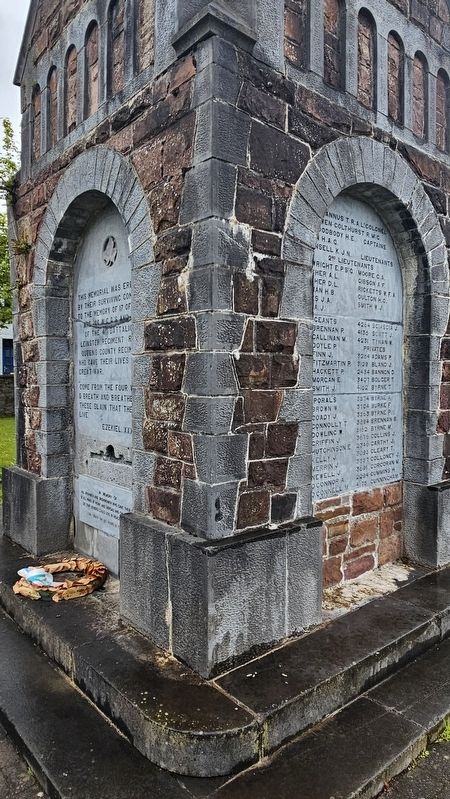
This memorial was erected by their surviving comrades to the memory of 17 officers and 160 N.C.O.’s and men of the 4th Battalion Leinster Regiment (Royal Queens County Regiment) who gave their lives in the Great War. “Come from the four winds O . . . — — Map (db m305279) WM
The Ridge, comprised of a great bed of gravel and sand, runs from near Timahoe to beyond Tullamore. It was formed by an esker (glacier or ice stream piled up in its course) from the Ice Age. The Ridge was used as a road from the earliest times. The . . . — — Map (db m305419) HM
1530 [Gaeilge:] “Tá ár sinsir i Laois leis na cianta. Seinnim ceol agus deirim dánta le ceiliúradh a dhéanamh ar scéalta saibhre ár bpobail. Is í an Ghaeilge ár dteanga agus tá dlíthe agus nósanna dár gcuid féin againn. Tá na . . . — — Map (db m304915) HM
This hospital was built in 1808. Administered by Dr John Jacob it replaced the infirmary located in the Stone House which had been founded mid-18th century by his father, Dr Michael Jacob. Four generations of the Jacob medical family were involved . . . — — Map (db m305441) HM
1548 [Gaeilge:] “Is ón gcoillearnach dhlúth a chlúdaíonn an chuid seo den tír atáimid ag fáil an adhmaid le haghaidh an Dúin. Is contúirteach an rud é na crainn a leagan. Bíonn na Gaeil i bhfolach sna coillte seo. Ionsaíonn . . . — — Map (db m304913) HM
[Gaeilge:] Dún Túdarach, chun clann Ghaelach a chur faoi chois Ba iad fórsaí Túdaracha Shasana a thóg Sean-Dún Phort Laoise sna blianta 1547–48 chun cur faoi chois chríocha Ghaelacha chlann Uí Mhórdha agus Uí Chonchúir. Bhí sé . . . — — Map (db m304907) HM
[Gaeilge:] Eaglais do na Lonnaitheoirí Faoin mbliain 1560, bhí na lonnaitheoirí Sasanacha ina gcónaí i mbaile beag múrtha a tógadh timpeall an tSeandúin. Thug siad Maryborough air agus bhunaigh eaglais, reilig agus muileann ann. . . . — — Map (db m305186) HM
This artistic sculpture designed by John O’Connor to commemorate the transatlantic flight in 1928 of the world-famous Aviator Col. James Fitzmaurice. Funded by Laois County Council and The Department of Environment and Local Government. Officially . . . — — Map (db m305275) HM
This plaza commemorates a famous aviator Colonel James Fitzmaurice who was reared in Portlaoise and went to school in the local CBS. Near here he saw the first plane built in Ireland by the Aldritt family. Fitzmaurice was the co-pilot of the . . . — — Map (db m304916) HM
Constructed between 1548–56 to underpin the plantation of Laois-Offaly. From 1547 to 1607 there were thirty armed uprisings against the plantation. The Fort and town survived most of the uprisings but the town was burnt down in 1580 during the . . . — — Map (db m304912) HM
[English:] In memory of all Irishmen and Irishwomen who gave their lives in all wars at home and abroad and on U.N. service so that others could live in peace and freedom [Gaeilge:]Ar dheis Dé go raibh a . . . — — Map (db m305277) WM
South Panel: “This island is ours, and have it we will, if the leaders be true to the people, and the people be true to themselves” East Panel: “Let laws and institutions say what they will, this fact will be stronger than all laws, . . . — — Map (db m304846) HM
[Gaeilge:]
Baile Múrtha
D’fhás Port Laoise thart ar an Seandún a thóg na lonnaitheoirí Sasanacha in 1547–48. Thug na ballaí cosaint do na lonnaitheoirí agus théidís isteach sa bhaile trí na háirsí agus na lánaí ar an Príomhshráid. Bhí . . . — — Map (db m304857) HM
This is the site of Maryborough Mill, a substantial water-powered flour mill dating from c. 1827. It was operated by the Odlum milling family from 1865. Roller mills were installed in 1887 as part of a modernisation project initiated by William . . . — — Map (db m304914) HM
Maryborough Gaol was attached to the Courthouse on the site now occupied by Dunamaise Theatre and Arts Centre. The Gaol was the scene of public executions (as many as ten a year). The most notorious of those executed were Grant the Robber and the . . . — — Map (db m304858) HM
Built c.1560 for the inhabitants of the Fort in the reign of King Philip and Queen Mary. The belfry tower remains as the second oldest building in the town. Its most famous vicar was Rev Thomas Mosse whose son Bartholomew founded the Rotunda in . . . — — Map (db m304875) HM
The courthouse, with its Morrison facades, was built in 1782 as its predecessor was destroyed by fire. It was the scene of many famous trials. Queens Co. (Laois) County Council held its inaugural meeting here in 1899. It was Laois County Council . . . — — Map (db m304872) HM
(Side One) Portlaoise — Links with the Past Old Fort of Maryborough Portlaoise was the first planted town in the English speaking world. The town grew around the Old Fort of Maryborough, known as Fort Protector, . . . — — Map (db m304845) HM
Maryborough Technical School first opened to pupils in 1907 on the initiative of the Queen’s County Committee for Agriculture and Technical Instruction. It was one of the first technical schools in Ireland. The early classes included book-keeping, . . . — — Map (db m304878) HM
This was for many years the home of the famous Jacob medical family. An early Dr. Jacob founded the first infirmary in Maryborough (now Portlaoise) in 1756. His son, Dr. John Jacob, founded the County Infirmary in 1808 and built this house c.1810. . . . — — Map (db m305418) HM
The Presentation Sisters came to Portlaoise on the invitation of the parish priest, Very Rev. Nicholas O’Connor, in 1824. They were at first housed in the Old Infirmary at the Stone House, the oldest building in town, which is now part of the . . . — — Map (db m305187) HM
The Great Southern and Western Railway was extended to Maryborough (now Portlaoise) between 1844–46. The station was designed by Sancton Wood and built using local limestone at a cost of £5,000. A plaque beside Platform Two commemorates William . . . — — Map (db m305444) HM
Brother Vincent Culkin, arrived in Maryborough in 1847 on the invitation of the parish priest, Very Rev. Nicholas O’Connor, to establish only the second Christian Brothers’ School in Leinster, outside Dublin. Fr O’Connor gave his house to the . . . — — Map (db m304909) HM
This is the site of the Roman Catholic Parish Church opened in 1822. It was built in the gothic style by Very Rev. Nicholas O’Connor, parish priest, who was responsible for the coming of the Presentation Sisters, in 1824, and the Christian Brothers, . . . — — Map (db m305088) HM
This hospital was founded in 1833 as the District Lunatic Asylum for Queen’s County, King’s County, Longford and Westmeath. It became known as Portlaoise District Mental Hospital in 1925. A substantial extension in red brick was added in the 1930s. . . . — — Map (db m305438) HM
The church was built in 1803 and consecrated the following year. It replaced the original St Peter’s Church of c.1560. The church has a very striking obelisk spire designed by James Gandon, architect of the Four Courts in Dublin. St Peter’s Church . . . — — Map (db m304840) HM
[Gaeilge:] Tá cailín óg ina cónaí taobh amuigh den Dún in éineacht lena máthair. [English:] A young girl lives outside the Fort with her mother. 1567 [Gaeilge:] “Bhíodh cónaí orainn i . . . — — Map (db m305189) HM
[Gaeilge:] Tá trodaire Gaelach timpeall an Dun. [English:] A Gaelic fighter surrounds the Fort. 1599 [Gaeilge:] “Rinne saighdiúirí Sasanacha sléacht ar mo mhuíntir agus thiomáin siad iad . . . — — Map (db m305188) HM
[Gaeilge:] William Dargan (1799–1867) Tógálaí, Daonchara, fear as Laois: Bunaitheoir an Iarnróid in Éirinn. Cuireadh suas an phlaic seo ar chomóradh 150 bliain a bháis. [English:] William Dargan (1799–1867) Builder, . . . — — Map (db m305447) HM
1914 – 1918 On the 100th anniversary of the outbreak of World War 1 this plaque was rededicated to the memory of all Irishmen and Irishwomen who died in the Great War. [Gaeilge:] Ar dheis Dé go raibh gach anam dílis . . . — — Map (db m305281) WM