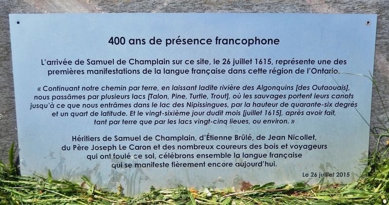
On Premier Road at Champlain Park Road when traveling south on Premier Road.
[English] The arrival of Samuel de Champlain on this site, on July 26, 1615, represents one of the first manifestations of the French language in this region of Ontario. "Continuing our way by land, after leaving . . . — — Map (db m215900) HM
On McIntyre Street East just south of Wyld Street, on the right when traveling north.
North Bay Public Libraries have been located on this downtown block — bordered by McIntyre, Wyld, Worthington and Sherbrooke Streets — since 1914 when a Carnegie Library opened its doors. The Carnegie wasn't North Bay's first library. . . . — — Map (db m215930) HM
Near Memorial Drive, 0.6 kilometers south of Main Street West, on the right when traveling south.
The rivers and lakes of northern Ontario have been highways for travel and commerce for hundreds of years. Used extensively by first nations and European explorers, Lake Nipissing became a major highway with half the furs shipped to . . . — — Map (db m215897) HM
On Main Street West, 0.1 kilometers north of Ferguson Street, on the right when traveling north.
The Cormack Block was built circa 1890 and was named for John G. Cormack, North Bay's first pharmacist (druggist). The block is recognized as the oldest Main Street commercial structure that still stands and over the years it has housed . . . — — Map (db m215876) HM
Near Ferguson Street at Oak Street when traveling west.
The extensive Canadian Pacific Railroad yards and repair shops dominated the North Bay waterfront for better than three quarters of a century. CPR steel reached what was to become North Bay in 1882 and it soon became evident that this . . . — — Map (db m215894) HM
Near Memorial Drive, 0.4 kilometers south of Main Street West, on the right when traveling south.
Don King served his country as a war veteran and also served our community as a capable, committed and conscientious Reeve, Councillor and Alderman over a 35 year period. He was a staunch supporter of community projects that he believed would . . . — — Map (db m215985) HM WM
On Main Street West at Algonquin Avenue, on the left when traveling north on Main Street West.
Scottish born John Ferguson (1861-1946), a nephew of Canadian Pacific Railroad vice-president Duncan McIntyre, arrived here with CPR steel in 1882. Credited with being a key founder of North Bay, Ferguson, whose vocation was described as . . . — — Map (db m215887) HM
Near Memorial Drive at Colgan Avenue, on the right when traveling north.
This arch was erected by the North Bay Travellers and their friends in 1928. In 1934 this group was incorporated as the North Bay Club of the Associated Canadian Travellers, and the arch became the logo of the City of North Bay. On the 50th . . . — — Map (db m215997) HM
On Memorial Drive at Stanley Street, on the right when traveling north on Memorial Drive.
The lonely piece of pavement curving off Memorial Drive next to this heritage site plaque, and deadending at the Stanley Street bridge, was once part of North Bay's only road link to the southern part of the province. Construction of . . . — — Map (db m215995) HM
On Ferguson Street at Oak Street when traveling west on Ferguson Street.
This public gathering place is named in honour of Jack Burrows — athlete, husband, father, grandfather, businessman, Rotarian, long time public servant and North Bay Mayor from 1995 to 2003. Of Irish stock, the Burrows family arrived in . . . — — Map (db m215892) HM
On Memorial Drive at Colgan Avenue, on the right when traveling north on Memorial Drive.
Born in France about 1598, this explorer, fur trader and interpreter came to Canada in 1608. Under orders from Samuel de Champlain, he spent the following two years with the Algonquins of Allumette Island. He was then sent to the Nipissing Indians . . . — — Map (db m107579) HM
On Trans-Canada Highway (Provincial Highway 17) 3.5 kilometers east of Provincial Highway 11, on the right when traveling east.
The historic La Vase (Mud) Portages began at the head of the nearby pond. These three portages, connecting Trout Lake and the lower La Vase River, were linked by small navigable streams and ponds. They formed part of the great canoe route via the . . . — — Map (db m107582) HM
Near Premier Road at Champlain Park Road when traveling south.
From this point the Canadian explorers and early fur-traders caught their first glimpse of Lake Nipissing as they paddled westward on their journey from Montreal by way of the Ottawa, Mattawa and French Rivers to the Great Lakes. Champlain viewed . . . — — Map (db m199966) HM
On Oak Street West at Ferguson Street, on the left when traveling south on Oak Street West.
Stepping off a passenger train at the Canadian Pacific Railway Station, visitors to North Bay in the early 1900s saw a very different town than exists today. There was a large park on one side of the station, and across the street, known . . . — — Map (db m215893) HM
Near Memorial Drive, 0.8 kilometers south of Main Street West, on the right when traveling south.
The vast body of water before you is a shining Northern gem. Known as Lake Nipissing, the name being derived from an Aboriginal term meaning "little water", it is one of the ten largest lakes in Ontario at roughly 65 km by 25 km. When . . . — — Map (db m215993) HM
On 1st Avenue West north of Ferguson Street, on the right when traveling north.
This city block bounded by Fraser, First, Ferguson and Second became the site of the North Bay Normal School, which opened in 1909 and still stands on the corner of First & Fraser. In 1917, the province deeded the remainder of the tract for use as a . . . — — Map (db m195967) HM
On Memorial Drive just south of Regina Street, on the left when traveling south.
North Bay citizens have long enjoyed a refreshing tankard and for a short time in the early 20th Century, residents were served by their own brewery. The New Ontario Brewing Company Ltd. was the area's first commercial brewery, producing . . . — — Map (db m215898) HM
On Trout Lake Road (Provincial Highway 63) 0.1 kilometers west of Connaught Avenue, on the right when traveling south.
The first known lockup in North Bay was a rudimentary log structure built in 1886 at the corner of Main and Wyld Streets. Two years later the province constructed a court house and lockup on Bye, now Plouffe, Street which evolved into a . . . — — Map (db m216000) HM
On Memorial Drive, 0.2 kilometers south of Main Street West, on the right when traveling south.
North Bay has a long and storied hockey history and, over the years, a number of rinks and arenas have served the needs of citizens. The North Bay Arena Rink stood near this site at the corner of Main Street West and Murray Street. Today . . . — — Map (db m215947) HM
Near Memorial Drive, 0.6 kilometers south of Main Street West, on the left when traveling south.
In 1999, Barry Jacobs, a dedicated volunteer with the Heritage Railway Co., had a dream; a full scale carousel to complement the successful train at the North Bay Waterfront. Rod Johnston, one of the founders of the Heritage Railway Co. embraced . . . — — Map (db m215989) HM
On 1st Avenue West, 0.2 kilometers north of Ferguson Street, on the right when traveling north.
[English] The red brick structure on this site was the home of teacher education in North Bay from 1909 until 1972. Originally the North Bay Normal School, it was renamed North Bay Teachers' College in 1953.
In 1972 the teacher education . . . — — Map (db m195971) HM
On Main Street West at Fraser Street, on the right when traveling south on Main Street West.
John Ferguson was North Bay's first postmaster for a few weeks in 1883, operating out of his boardwood cabin. He was succeeded by William McDonald who opened a general store and post office that same year. McDonald was postmaster for 25 . . . — — Map (db m215800) HM
On Ferguson Street at McIntyre Street West, on the left when traveling east on Ferguson Street.
The construction of the Town Hall represented a defining moment in North Bay's early development. Until it was built, most municipal affairs were carried out at the Cormack block, located beside the current pedestrian laneway on Main . . . — — Map (db m215954) HM
On Ferguson Street at McIntyre Street East, on the right when traveling east on Ferguson Street.
A zealous Methodist missionary descended from an early New England family, Huntington was born in Kemptville. With his ordination in 1854 he commenced a long Christian ministry, serving various congregations in eastern Ontario and Quebec until 1882 . . . — — Map (db m107571) HM
On Main Street West at Algonquin Avenue, on the left when traveling south on Main Street West.
The Royal Theatre, under various names and owners, was one of North Bay's most important cultural and entertainment venues for close to forty years. Built in 1908 for $50,000 to a design by H. W. Angus, the Royal Theatre, also called . . . — — Map (db m215895) HM
On McIntyre Street West just north of Ferguson Street, on the right when traveling north.
On this site in 1975 an accident during routine excavation led to the biggest single tragedy and loss of life in North Bay's history. In the afternoon of January 8, a five man crew from the gas company working next door using a backhoe . . . — — Map (db m215891) HM
On Main Street East just north of Judge Avenue, on the right when traveling north.
From 1979 to 2009, a Bomarc missile was mounted on a pedestal at this site in Lee Park (now Veteran's Fields) serving as a monument to one of the most important and controversial aspects of North Bay's history in the late 20th century. . . . — — Map (db m215899) HM
On Main Street East, 0.1 kilometers north of Wyld Street, on the right when traveling north.
The Capitol Theatre opened on this site on June 1, 1929. The sold out opening night movie feature was a "talkie" titled, In Old Arizona. Known as "Northern Ontario's Most Beautiful Theatre," it resembled that of old Hollywood. The walls . . . — — Map (db m215799) HM
Near Memorial Drive just south of Colgan Avenue, on the right when traveling north.
[English] The CF100 “Canuck” was conceived to meet the demanding requirements of defending a country as vast as Canada. It was a two place, all weather high altitude long range interceptor built in Canada. It first . . . — — Map (db m215998) HM WM
On Regina Street at Oak Street East, on the right when traveling east on Regina Street.
In 1900 the Ontario Government ordered a survey for a railway from North Bay to the head of Lake Timiskaming to encourage settlement and provide access to mineral deposits. Construction of the Temiskaming and Northern Ontario Railway began in 1902, . . . — — Map (db m107572) HM
On Main Street East just north of Judge Avenue, on the right when traveling north.
To mark the 50th anniversary of the end of WWII this park and the playing fields therein are gratefully dedicated to all those who have served Canada in any military endeavour or peacekeeping mission. They served with valour so we may remain free. . . . — — Map (db m215798) WM
On Memorial Drive, 0.6 kilometers south of Main Street West, on the left when traveling south.
The Winter Wonderland Carousel was instigated by the North Bay Carousel Carvers. As the North Bay Heritage Carousel came close to completion it became apparent that the carvers would soon be out of work. However, this stalwart band of volunteers . . . — — Map (db m215994) HM