This highway was once one of the nation's most significant routes, serving as one of the earliest north-south connections from Canada to Louisiana. Dubbed the "pine to palm" highway, it stretched from Winnipeg, Manitoba, to New Orleans, Louisiana. The highway was named in honor of Thomas Jefferson, who, through the Louisiana Purchase in 1803, effectively doubled the size of the United States.
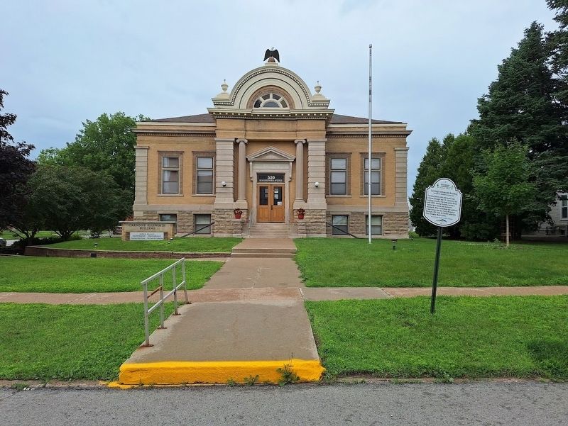
Constructed in 1904 with funds from Andrew Carnegie and E.S. Ellsworth, this building served as the town public library until 2000. Interior features include a stained glass dome and elaborate woodwork. After restoration and additions, it now . . . — — Map (db m276830) HM
Soule arrived in Iowa Falls in 1864. He was a druggist, but quickly started working for the railroads, serving in various capacities from brakeman to passenger train ticket agent. He was an accomplished ball player, directed the town band, and . . . — — Map (db m276852) HM
Baptists first organized in Iowa Falls in 1862 and in 1866 purchased the land which the present church occupies. Built in 1898, it is the only remaining nineteenth century church building in Iowa Falls. The architecture and magnificent stained . . . — — Map (db m276843) HM
Originally this land was the town square for Rocksylvania, the Quaker settlement plotted by B.I. Talbott in 1854. It was renamed in 1943 for the beloved teacher Julia O'Neil (1871-1941) who served the East Side School for nearly fifty years. — — Map (db m276732) HM
Constructed in 1904 at a cost of $50,000, this opulent home was designed by Smith and Gage Architects of Des Moines for the Jones family. Sheathed in Indiana limestone, the three stories boast solid mahogany and oak woodwork inside, imported . . . — — Map (db m276736) HM
The Jefferson Highway was formed in 1915 as the major north and south highway. From Winnipeg to New Orleans, it was named in honor of Thomas Jefferson for his role in the 1803 Louisiana Purchase. Lincoln Highway, the first east coast to west coast . . . — — Map (db m251159) HM
James and Lucinda Mahaffie served stagecoach passengers and other travelers at this farm starting in 1858. The stone farmhouse was built in 1865. Today, Mahaffie Stagecoach & Farm Historic Site is the only stop left on the Santa Fe Trail that is . . . — — Map (db m312507) HM
The Jefferson Highway was created in 1915 as an early north-south automobile highway through America. The route went from Winnipeg to New Orleans through lands procured by President Thomas Jefferson in the Louisiana Purchase. Miami County . . . — — Map (db m312678) HM
The Texas and Pacific Railway established a
station on the main line at Bunkie in 1882. The
current depot, built in 1911 and listed on the
National Register of Historic Places, is the only
existing reminder of the importance of the
railway to . . . — — Map (db m208821) HM
The Bunkie Post Office was established on January 26,
1883, originally located on Main Street, relocated here
in 1937. First postmaster Thomas B. Kimbro was
succeeded by Louis W. Anderson, then John D. Earnest,
Levi West, Ewell West and . . . — — Map (db m283156) HM
The 20-year-old Louisiana Hoop Company
relocated to Bunkie in 1930. It had a priority
status to supply highly demanded barrels during
WWII. In 1952 the business transitioned to
manufacturing hardwood furniture. In 1962 LHC
was the last . . . — — Map (db m283098) HM
What part does Avoyelles play in the Jefferson Highway corridor?
Highway 71 passing through Bunkie is on the
Jefferson Highway. Originally, it entered into
Avoyelles from Rapides Parish on the northside at
Shirley Road leading into . . . — — Map (db m284070) HM
Named for U.S. President Thomas Jefferson. Completed 4 Feb. 1926. "Pine to Palm" route, one of first intercontinental highways. Extends 2,194 miles from Winnepeg, Canada, through Jefferson, ending in New Orleans at St. Charles Ave. and Common St. . . . — — Map (db m100376) HM
The Natchitoches Tourist Park and Campground,
situated west of what was the Normal College,
was established in 1922 on the Jefferson
Highway. One of the largest campgrounds on the
highway, campsites were free for up to seven
nights, while the . . . — — Map (db m250520) HM
Natchitoches is one of the many stops along the Jefferson
Highway, one of the country's first intercontinental
roadways. Today, a portion of the Jefferson runs through
the Natchitoches Historic Landmark District of Jefferson
Street, Front . . . — — Map (db m250518) HM
The Louisiana Purchase of 1803 was the first large step for the United States to complete its calling of Manifest Destiny to expand from sea to shining sea. Though national attention focused on east-west travel it would be another 114 years . . . — — Map (db m188373) HM
A trading post developed at this site on Bayou Boeuf in the early nineteenth century was known as White's Landing. The landing was well used, but the bayou was an unreliable means of transportation for planters to get their crops to market due to . . . — — Map (db m116035) HM
Named for U.S. President Thomas Jefferson, this highway was completed in 1926 and originally extended 2,194 miles from Winnipeg, Canada and onto New Orleans, Louisiana. Its route in central Louisiana ran through Natchitoches, Colfax, Pineville, . . . — — Map (db m250523) HM
1806 15 Ms. South of Butler
Explorer Zebulon Pike Parley
With Osage Chief
1863 Burning of Butler by Order No. 11
During the Civil War
Where the Civil War Began
Brother Against Brother
Post Civil War Reconstruction
[Mural . . . — — Map (db m39898) HM
This highway was organized in November, 1915 at New Orleans and extends to Winnipeg Canada. It was organized for the dual purpose of providing a great north and south highway and to honor the name of Thomas Jefferson for the part he took in the . . . — — Map (db m312278) HM
Old Pike Road is the oldest, most westerly, north-south road in Clay County. Starting at Kawsmouth on the north bank of the Missouri River in Harlem it ran north, skirting on the east an old river scar the settlers called “the slough bank,” until it . . . — — Map (db m252107) HM
The Jefferson Highway was an automobile highway stretching through the central United States from New Orleans, Louisiana, to Winnipeg, Manitoba, Canada. The Jefferson Highway was replaced with the new numbered US Highway system in the late . . . — — Map (db m247730) HM
Arthur Boots built this Streamline Moderne style motor court in 1939,
featuring a “Radio in Every Room,” at the intersection of Route 66
and the Jefferson Highway, known as the “Crossroads of America.”
The motel was expanded in 1946 and restored . . . — — Map (db m251588) HM
Established in 1915, this auto trail traveled over 2,400
miles from Winnipeg, Canada to New Orleans,
Louisiana. It was one of the first north-south auto
routes in America, with Carthaginian James D. Clarkson
its General Manager from 1916 to . . . — — Map (db m251591) HM
• Was a 2290 mile transcontinental "National Trail" from Winnipeg, Canada to New Orleans, Louisiana;
• Roadway through town ran from North Broadway to Gentry Avenue, then on SW 2nd Street and back to South Broadway;
• Route formed what . . . — — Map (db m73153) HM
Prior to the movement of settlers into Texas in the 1830s and 1840s, the
northern portion of the road, which passed through what would later
become Honey Springs, was known as the Osage Trace. During the late
18th and early 19th centuries, the . . . — — Map (db m243507) HM
The historic Jefferson Highway route was established in 1916 and went from Winnipeg, Canada, to New Orleans, Louisiana, over approximately 2,400 miles. The route was one of the first North-South highway routes across the country. The route through . . . — — Map (db m259599) HM
This station was established in 1925 by Muskogee businessman James M. Anthis at an important intersection of the Jefferson Highway through Muskogee. The station was designed with an English cottage-style look that was favored by Marland Oil founder . . . — — Map (db m259579) HM
The ten story Severs Hotel was completed in 1912 by Muskogee businessman F.B. Severs who died shortly before its opening. The hotel hosted numerous events and many celebrities over the years including Babe Ruth, Helen Keller, Burt Lancaster and . . . — — Map (db m259600) HM
In the late 1800's, most bridges in Texas only supported wagon traffic. As automobile use became more abundant and the Good Roads Movement gained momentum, the need for better bridges became apparent. The beginning of the 20th century ushered in . . . — — Map (db m234160) HM