Abraham Ten Broeck (1734-1810) built this grand mansion in the Federal style after the destruction of his family home on Broadway in the great fire of 1797.
Descended from one of Albany's founding New Netherland families, he was a businessman, . . . — — Map (db m139507) HM
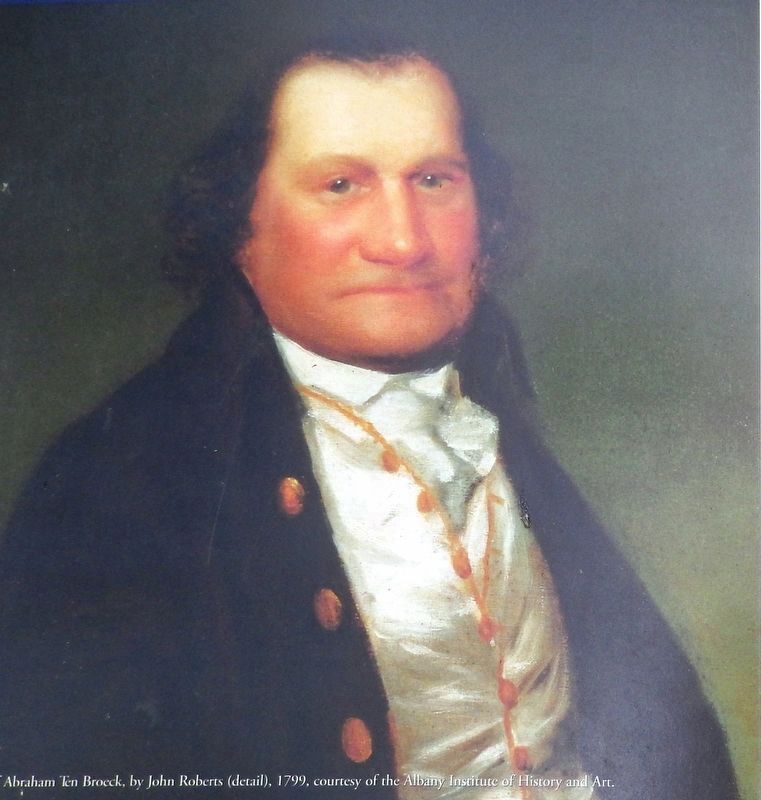
On this site, two generals of the Revolutionary War were interred. Major General Philip Schuyler and Brigadier General Abraham Ten Broeck, both natives of Albany.
General Philip Schuyler died in November of 1804 and was buried here following a . . . — — Map (db m139508) HM
In Honor of the 200th Anniversary of the
1797 City of Albany 1997
Serving as the Capital City of the State of New York
For twenty years, after the establishment of the State of new . . . — — Map (db m5540) HM
The Declaration of Independence
Was first publicly read in
Albany by order of the
Committee of Safety
July 19, 1776 in front of this
City Hall, then on this site.
This memorial of the event
was placed here by the
citizens
. . . — — Map (db m116673) HM
Fort Frederick Governor Edmund Andros Made an Inspection in Albany in 1676 and Found Fort Orange, Located Near the Foot of Madison Avenue in Poor Condition. He Ordered a New Fort Constructed at a Site in the Center of State Street Just West of Lodge . . . — — Map (db m5248) HM
Through this place passed
Gen. Henry Knox
in the winter of 1775-1776
to deliver to
Gen. George Washington
at Cambridge
the train of artillery
from Fort Ticonderoga
used to force the British
Army to evacuate Boston . . . — — Map (db m227122) HM
In charge of artillery for the Continental Army, Colonel Henry Knox was given the task to bring cannon captured from the forts in Crown Point and Ticonderoga to Boston. With ice barely able to support the weight of the sleds and cannons, Colonel . . . — — Map (db m227011) HM
Named in honor of the Marquis de LaFayette who commanded troops at Albany in 1778. Returned here in 1784 on his way to Fort Schuyler was entertained by the State of New York and the City of Albany during his visits in 1824-1825. — — Map (db m64999) HM
The New York State Organization National Society Daughters of the American Revolution honors the courage and valor of more than 41,000 patriot troops in the line. The levies and the militia from New York Colony and State who left their homes and . . . — — Map (db m64998) WM
The
Schuyler Mansion
Erected 1762
The Home of
Major General Philip Schuyler
of the American Revolution
Patriot * Soldier * Statesman
* 1733 1804*
Acquired by the State of New York 1911
Restored and Dedicated
October . . . — — Map (db m58882) HM
Major General Philip Schuyler commanded the Northern Department of the Continental Army until August 1777. After the Battles of Saratoga, British General Burgoyne stayed here as a prisoner-guest.
Revolutionary Heritage Trail — — Map (db m58883) HM
Encampment of the Northern
Department Continental Army
August 9-September 8-1777
from this place August 9-1777
Gen. Ebenezer Learned
with his Massachusetts Brigade
marched to relieve
Fort Stanwix — — Map (db m7666) HM
Prior to the construction of the New York State Barge Canal
and dam at Crescent, the Mohawk River was shallow and
fordable most of the year. For centuries, Native Americans
had crossed at this place. In 1755, during the French and
Indian War, a . . . — — Map (db m138984) HM
Military encampment 1777 Here, in the days leading up to the Battles of Saratoga, 5,000 – 8,000 Continental soldiers were garrisoned. — — Map (db m37454) HM
1735 - 1927
Van Schaick Mansion
Home Of
John G. Van Schaick
and his Wife Anna Patriot Americans
Built by Anthony Van Schaick
Son of Goosen Gerritsen original patentee
Headquarters
August 18-September 8-1777
Northern . . . — — Map (db m7250) HM
In 1777, this mansion was the headquarters for the Northern Department of the Continental Army, and the site where the victorious Saratoga Campaign was planned. Revolutionary War Heritage Trail — — Map (db m37455) HM
The plans for the Battle of Saratoga were drawn up in this house in the summer of 1777, when the American Army was headquartered here. That April General Philip Schuyler and 5,000 troops retreated from Fort Edward in advance of Burgoyne’s superior . . . — — Map (db m37457) HM
Through this Place Passed
Gen. Henry Knox
In the Winter of 1775 - 1776
To Deliver To
Gen. George Washington
At Cambridge
The Train of Artillery
From Fort Ticonderoga
Used to Force the British
Army to Evacuate Boston . . . — — Map (db m23749) HM
1755 Constructed as Military Road from
Albany to Lake George by Provincial
Troops from New York, New England
and New Jersey under command of
Major General William Johnson
———
Named in honor of Major General . . . — — Map (db m24514) HM
Near here Andrew Hannay raised a company of volunteers October 1777
to oppose invasion of Burgoyne who surrendered before their arrival — — Map (db m135130) HM
Slingerland-
Lagrange Farm
Family Owned 12 Generations.
Stone House Built c.1750's.
Home of Revolutionary War
Soldier Albert Slingerland. — — Map (db m140968) HM
Col. Schenectady militia during American Revolution owned farm here 1765 to death in 1799. Buried on high knoll above reservoir. — — Map (db m144957) HM
Jacob Van Aernam
1723 - 1813
Capt. 3rd Albany Regiment
Leader of Patriot forces
in the Helderberg region
during American Revolution
Lived on farm here — — Map (db m44020) HM
Through this place passed
Gen. Henry Knox
in the Winter of 1775 - 1776
to deliver to
Gen. George Washington
at Cambridge
the train of artillery
from Fort Ticonderoga
used to force the British
Army to evacuate Boston . . . — — Map (db m23447) HM
Original part built c. 1816. revolutionary War Captain. Served 3 area churches from 1794-1825. His descendants lived in home until 1922. — — Map (db m136073) HM
Burial Site of Soldiers of the Revolutionary War
John Oliver 3rd Regiment
Albany County Militia John Sager 1st Regiment Line
New York State — — Map (db m244943) HM
Caves are formed when limestone is dissolved by flowing water. In the ceiling at the back of the cave you can see a large, natural chimney where water has seeped into the rock from above. As limestone dissolves, calcite is deposited to from . . . — — Map (db m12728) HM
Here in 1782 Major Moses Van Campen, a soldier of the Revolution, captured by the Senecas, keepers of the Western Door of the Iroquois Confederacy, ran the gauntlet thirty rods west to their ancient council house, which is now preserved in . . . — — Map (db m157328) HM
The area around Scio was first settled around 1805 by Joseph Knight, a minuteman in the American Revolution. Knights Creek, which flows into the Genesee River near Scio, is named for him. Before getting its final name, Scio was called Bloods Corner . . . — — Map (db m175123) HM
This fort is named in honor of
Major General
Philip John Schuyler
Continental Army
November 22, 1733 - November 18, 1804
Soldier - Statesmen
— — Map (db m193309) HM WM
Marble Hill Playground is located on Marble Hill Avenue, between West 228th and West 230th Streets. The City of New York acquired this property, along with the area that comprises the Marble Hill Houses, on August 26, 1948. The Board of Estimate . . . — — Map (db m226347) HM
Northwest of this tablet
within a distance of 600 feet stood the
Original King's Bridge
and its successors from 1693 until 1913
when Spuyten Duyvil creek was filled up.
Over it marched the troops of both armies
during the American . . . — — Map (db m172740) HM
Here Rests Lewis Morris, "signer" Declaration of Independence; Gouverneur Morris, "penman" Constitution of U.S.A. Judge R.H. Morris, Mayor of New York. — — Map (db m160849) HM
Site of the redoubt thrown up here in October, 1776 by American troops under General Heath to protect the retreat of Washington's Army from New York to White Plains. — — Map (db m12677) HM
Near this site on October 18, 1776, Col. John Glover and 600 Patriots held off British and Hessian forces under Gen. Howe long enough to save Washington’s troops from destruction, enabling them to withdraw to Westchester and ultimate victory. Bronx . . . — — Map (db m32013) HM
Glover’s Rock marks the site of the Battle of Pell’s Point on October 18, 1776. Before the American Revolution, the Siwanoy Native Americans used the rock as a lookout point along their trading route. The glacial granite rock is now named for . . . — — Map (db m98622) HM
Prison Window built of Holland brick and stone from the old Sugar House Duane Street 1763 – 1892 Used by the British as a prison for American soldiers 1776 – 1783 Cunningham provost marshal Presented by T.J. Oakley Rhinelander Esq. to the Colonial . . . — — Map (db m53827) HM
This Revolutionary War landmark is the oldest house in the Bronx and became the first historic house museum in New York City. It is a National Historic Landmark listed on the National Register of Historic Places and is a proud New York City . . . — — Map (db m53830) HM
Here in 1781, to deceive the British, General George Washington kept campfires burning in the area surrounding the house while he gained time for safe withdrawal of his troops across the Hudson River. The property on which this magnificent manor . . . — — Map (db m53824) HM
The lower Hudson Valley and the Bronx Terminal Market share a rich and colorful past.
Macomb's Dam Across the Harlem River
In 1814, Robert Macomb built a dam and toll bridge across the Harlem River in the vicinity of . . . — — Map (db m241545) HM
“King’s Bridge and the heights adjacent, of the utmost importance to the communication between New York and the mainland, & to the security of the Hudson, were reconnoitered by Washington on horseback about June 16, 1776. By direction of the . . . — — Map (db m53814) HM
1776 - 1976 In memory of the approximately four hundred veterans of the War of Independence who were pioneers in settling the Broome County area. Washington at Valley Forge. — — Map (db m198162) WM
Indian Castle
Located near junction of
Castle Creek with Chenango
River. Called Otsiningo.
Destroyed Aug. 18, 1779
during Sullivan Campaign — — Map (db m93030) HM
Near This Point 18 August 1779
Camped the army of James Clinton en
route to join the forces of General John
Sullivan in the expedition against the Iroquois and their British allies in the war of
the American Revolution
Originally erected by . . . — — Map (db m92920) HM
A museum exhibit interprets the Sullivan-Clinton Campaign of 1779. The campaign destroyed Native American villages and crops throughout the Iroquois homeland. — — Map (db m94628) HM
Routes of the Armies of General John Sullivan and General James Clinton 1779
An expedition against the hostile Indian nations which checked the aggressions of the English and Indians on the frontiers of New York and Pennsylvania, extending . . . — — Map (db m93324) HM
The valleys of the Upper Susquehanna River were natural routes for Indians, traders and settlers. Oquaga, near Windsor, was an Indian fur-trading post, and became an objective of the Sullivan-Clinton Campaign of 1779. From a dam at the outlet of . . . — — Map (db m35164) HM
An expedition against the hostile Indian nations which checked the aggressions of English and Indians on the frontiers of New York and Pennsylvania, extending westward the dominion of the United States.
Rear Face:
Union near this point . . . — — Map (db m141807) HM
Revolutionary War veteran. Professor at Kings College. Deputy Secretary of State. Pioneer of Local Lands. Namesake of Harpursville and Harpur College. — — Map (db m93548) HM
Native American village near mouth of Big Choconut Creek. Destroyed by General Enoch Poor August 18, 1779, Clinton-Sullivan Campaign. — — Map (db m127570) HM
Dedicated to our Revolutionary War Veterans and The Early Residents buried in Gulf Cemetery Nelson Lingenfelter 1821 1842; Charles Lingenfelter 1822 1841; Darius C. Brace; Amanda Chatfield 1767 1829; Hannah Brown 1727 1809 ; Andrew . . . — — Map (db m133041) HM WM
In Memory of Major Adam Hoops
A soldier of the Revolution and founder of Olean, N.Y.
1804
and to keep in remembrance the patriots of the War for Independence who are buried in Cattaraugus County, New York — — Map (db m60156) HM
Routes of the Armies of General John Sullivan and General James Clinton. 1779. An expedition against the hostile Indian Nations which checked aggressions of the English and Indians on the frontiers of New York and Pennsylvania, . . . — — Map (db m229007) HM
This monument is dedicated to all women who served in and with the military from the days of the American Revolution through the present day — — Map (db m229003) WM
front face
An expedition against the hostile Indian nations which checked the aggressions of the week English and Indians on the frontiers of New York and Pennsylvania, extending westward the dominion of the United States. rear . . . — — Map (db m145844) HM
William McCreedy and family, burial site. Soldier in Revolution. Born 1755 - Died 1824. Early Methodist meeting held in nearby family home. — — Map (db m88480) HM
Here where the Great Iroquois Trail
turned east, there passed on the 21st day of
September, 1779, Lieutenant-Colonel William
Butler's force of 600 men from Major-General
John Sullivan’s army, on their march to the
Cayuga castle on the Great . . . — — Map (db m145775) HM
Routes of the General John Sullivan and General James Clinton
1779
An expedition against the hostile Indian Nations which checked the aggressions of the English and Indians on the frontiers of New York and Pennsylvania, extending westward the . . . — — Map (db m143350) HM
Early Cemetery Old Montezuma Cemetery Revolutionary War veteran Richard Damewood buried here 1850. Served at seige of British at Yorktown. — — Map (db m83546) HM
Town of Sterling Named after a Revolutionary officer, Lord Wm. Alexander Sterling. Set off from Cato 1812. First grist and saw mill built here in 1813 — — Map (db m79753) HM