From Horse Car to Streetcar
The Saint Paul City Railway used horse cars for its first route in 1872, but horses were expensive to feed and susceptible to disease and injury. As an alternative, the company tried cable cars in 1888, but an . . . — — Map (db m241851) HM
From Europe to America
Both concrete and steel were becoming more available for bridge construction in the late nineteenth century. This inspired designs for systems of steel reinforcing to produce longer concrete spans. Austrian engineer . . . — — Map (db m241850) HM
By the 1850s, the growth of Saint Paul was altering the landscape.
In the 1850s the Dakota were forced to leave, and Saint Paul's early settlers occupied the land. Immigrants established the North Star Brewery here, and . . . — — Map (db m231222) HM
Near 4th Street East west of Commercial Street, on the left when traveling west.
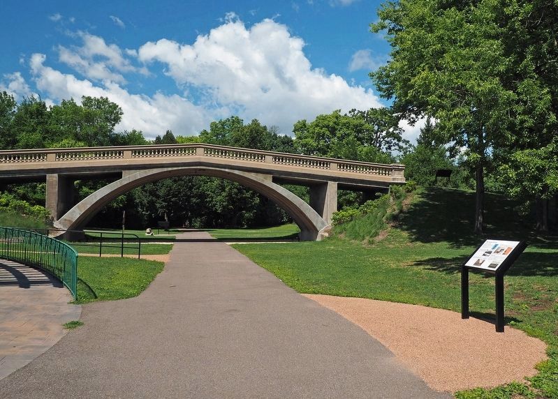
When the land was a busy rail yard, lineal concrete pads were used for train maintenance. Most of the concrete on the site was removed to make way for restored habitat. Community members advocated for keeping five of the concrete pads to . . . — — Map (db m231323) HM
For nearly 100 years this land was part of a wide rail corridor that stretched along the Mississippi River and up the Trout Brook and Phalen Creek valleys. Many sets of railroad tracks and buildings — including an "unwheeling house" — existed . . . — — Map (db m181758) HM
From One Product to Thousands
3M had its beginnings in 1902 at one small location in northern Minnesota. 3M's Saint Paul headquarters grew to become the heart of a major corporation between 1910 and 1962.
Founded in 1902, Minnesota . . . — — Map (db m232711) HM
On University Avenue W. west of Avon Street, on the right when traveling west.
This artwork recognizes the labor struggles of African American railroad porters. Porters served white passengers on luxury train cars that crisscrossed America from the late-1800s to the mid-1960s. Despite racial insults, low pay and hard . . . — — Map (db m241990) HM
On University Avenue W. west of Avon Street, on the right when traveling west.
"We fought on and won the admiration and respect of friend and foe"
–A. Philip Randolph, activist and union leader
As the Brotherhood pushed for equity and better working conditions, the Pullman Company . . . — — Map (db m246758) HM
On Wacouta Street at 4th Street, on the right when traveling south on Wacouta Street.
Union Depot Station is an important and unique multi-modal link to the greater metropolitan area and beyond. St. Paul Union Depot Company founders built the original Union Depot in 1881. One of America’s great rail stations from the early 20th . . . — — Map (db m76726) HM
On Neid Lane at Phalen Boulevard, on the left when traveling north on Neid Lane.
The Eastside, which makes up a third of Saint Paul, is comprised of many diverse neighborhoods. The earliest were developed as part of a walking city; the later ones came with the streetcars and automobiles. The oldest homes date to the 1850s and . . . — — Map (db m232441) HM
On Phalen Boulevard west of Cayuga Street, on the right when traveling west.
Living on Railroad Island
The small residential neighborhood immediately to the east of here is known as "Railroad Island," named so because it was at one time entirely surrounded by railroads. Railroad Island has long been home to many . . . — — Map (db m232442) HM
On Randolph Avenue near Shepard Road, on the right when traveling east.
... St. Paul, by the vigilance, energy, enterprise and united action of her leading citizens has succeeded in making herself the railroad center and headquarters of the northwestern region ... Railroads are now-a-days the most . . . — — Map (db m213804) HM
Built in 1931, the Saint Paul Municipal Grain Terminal is listed on the National Register of Historic Places. It is one of Saint Paul's few remaining connections to the once-vibrant grain industry on the riverfront. At one time, the entire . . . — — Map (db m234311) HM
On Main Street South (County Highway 101) south of Front Street East, on the left when traveling south.
Richard Warren Sears a 22-year-old Minneapolis and St. Louis Railway agent, first sold a shipment of watches from North Redwood in 1886. His mail-order enterprises eventually grew into Sears, Roebuck and Co., the nation's largest retailer and now a . . . — — Map (db m70526) HM
On Michigan Street at 6th Avenue West, on the right when traveling east on Michigan Street.
Completed in 1892
Designed by
R.S. Peabody & J.G. Stearns
Boston
Listed in the National
Register of Historic Places
1971
St. Louis County
Historical Society
————————
St. Louis . . . — — Map (db m79051) HM
On North Shore Scenic Drive/East Superior Street south of North 9th Avenue East, on the right when traveling north.
Perhaps no individual in the history of Duluth had such a dramatic influence on the port's infant development than Jay Cooke, a Philadelphia financier. Cooke's reign at the Head-of-the-Lakes was brief, but all-encompassing for commercial . . . — — Map (db m6379) HM
On West 3rd Street (State Highway 23) west of 130th Avenue West, on the right when traveling west.
Fond du Lac was incorporated in 1857 and became a part of the City of Duluth in 1895. This is the site of a major Chippewa Indian settlement from the sixteenth through the nineteenth centuries and is situated on the early canoe route along the St. . . . — — Map (db m43723) HM
On Greyhound Boulevard/3rd Avenue East, 0.4 miles north of 13th Street East, on the left when traveling north.
Train Depot
Early passenger service was by train. Hibbing's Train Depot was one block west of this spot. Many immigrants seeking work arrived here and many of these same men left from this same depot to serve their new country during World . . . — — Map (db m5137) HM
On Locomotive Street at Mountain Avenue, on the left when traveling east on Locomotive Street.
Originally a road switcher for use at Proctor Yard and Duluth ore dock operations of the DM&N R.R. It was then transferred to the O.I.M. Co. for mining and stripping operations at various Iron Range mines. Last used in the Mt. Iron Open Pit Ore Mine . . . — — Map (db m155588) HM
On Main Street (County Road 708) just east of Mountain Avenue, on the left when traveling east.
The Merritt Brothers made the first discovery of iron ore on the Mesabi Range in 1890, declaring it a "mountain of iron." With this find, their prospectors' camp lost its temporary aspect and began to swell in size and importance. On October 17, . . . — — Map (db m155585) HM
The 225 was purchased by the Duluth Missabe and Iron Range Railway Co. in June of 1941 and hauled over 44 million tons of iron ore from the Mesabi and Vermillion ranges.
The length of the engine and tender is 127 feet 8 inches, and stands over . . . — — Map (db m78615) HM
On County Road 526, off of Minnesota 169 (State Highway 169), on the right when traveling west on County Road 526, off of Minnesota 169.
On October 28, 1865, geologist Henry H. Eames returned to St. Paul after initiating a survey of the mineral wealth present in the Lake Vermilion area only to find an abundance of rumors concerning a valuable gold strike on the shores of that lake. A . . . — — Map (db m104381) HM
When iron ore was discovered on the Vermilion Range, Charlemagne Tower, Sr., George Stone, Charlemagne Tower, Jr., and George Stuntz formed the Minnesota Iron Company and acquired the Duluth and Iron Range Railway (D&IR). In 1883, they constructed a . . . — — Map (db m127863) HM
This steam locomotive was one of 12, received from the Baldwin Locomotive Works in 1910, used by the Duluth, and Iron Range Railway (as number 218) and later by the Duluth, Missabe and Iron Range Railway (as number 1218) to haul righ iron ore from . . . — — Map (db m107204) HM
Near County Road 101 (Business U.S. 169) at Sarazin Street, on the right when traveling west.
For many years, steamboats along the Minnesota River were the most efficient way for people and goods to reach the young city. However, in the mid-1860s, a new method of transportation arrived — the railroad. The first steam train rolled from . . . — — Map (db m213160) HM
On Sibley Street, 0.2 miles south of 4th Street West (Minnesota Highway 19), on the left when traveling south.
This is the approximate site of Eagle City which was settled in 1858 at the halfway point on the Henderson to Fort Ridgely Trail. This was the same year Minnesota became a state. A. (Michael) Cummings built a tavern/hotel which also became a United . . . — — Map (db m66949) HM
On State Highway 15 south of County Road 8, on the left when traveling north.
Here in 1856 settlers from Maine established a community that grew into a vigorous pioneer village including three churches & stores, two lodge halls, blacksmith shop, cheese factory – all built near the site of a 2½-story tamarack fort . . . — — Map (db m70766) HM
On Riverside Drive, 0.1 miles north of Hillsdale Street, on the left when traveling south.
Once on this site there stood a beautiful red brick and limestone railway station that was part of the great Chicago, Rock Island and Pacific Railway System. It was a stately building that served our community and the Rock Island System proudly for . . . — — Map (db m23173) HM
Near Interstate 35 at milepost 131,, 0.7 miles south of West Broadway Avenue (County Highway 2), on the right when traveling south.
Railroads were charted in Minnesota as early as 1853, but it was not until 1862 that Minnesota's first railroad began to operate on ten miles of track connecting St. Paul with St. Anthony (now part of Minneapolis). In 1870, the Northern Pacific . . . — — Map (db m5289) HM
Near Dellwood Road (State Highway 96) west of Kimbro Avenue N.
Constructing a railroad in the late 19th and early 20th centuries was a feat of skill, determination and hard labor. Each step took careful planning and routes often passed through remote areas with few roads and many dangers.
Step 1: Finding . . . — — Map (db m233665) HM
Near Dellwood Road (State Highway 96) west of Kimbro Avenue N.
Stillwater Welcomes the Iron Horse
Imagine the excitement of a chilly December day in 1870. You watch as workers hammer in the last few spikes to complete Stillwater's first railroad. Area residents had much reason to celebrate—railroads . . . — — Map (db m233663) HM
On Laurel Street east of Main Street North (Minnesota Route 95), on the right when traveling east.
A Trail for All Seasons
Opened in 2014, the Brown's Creek State Trail connects Stillwater with the Gateway State Trail. Nearly six miles long, the path travels along forests, ponds, Brown's Creek and the St. Croix River. Along the way . . . — — Map (db m233502) HM
On Neal Avenue N. at the Brown's Creek State Trail, on the right when traveling south on Neal Avenue N..
Explore the Trail
If you go east, you will catch glimpses of the Brown's Creek stream as you pass through open fields, shady ravines and golf courses. You can also see Minnesota's oldest standing stone bridge. At the eastern end, . . . — — Map (db m233733) HM
On 3rd Avenue West at 3rd Street North on 3rd Avenue West.
In 1901 the Supreme Court of the United States ordered the installation of a transfer track between the Great Northern Railroad, now the Burlington Northern, and the Minneapolis & St. Louis Railroad, now the Chicago and Northwestern.
This . . . — — Map (db m20574) HM
140 entries matched your criteria. Entries 101 through 140 are listed above. ⊲ Previous 100