On North Main Street, on the right when traveling north.
In 1901, Aquiles Arriola opened his store here with a great variety of goods lining the store walls. Arriola's son, Gustavo, grew up to be a well-known cartoonist with his own comic strip "Gordo". He wrote in his auto biography "Accidental . . . — — Map (db m71775) HM
On North Main Street near 8th Street, on the right when traveling south.
This single-story commercial building includes a partial basement, wide-open interior spaces, and a tall, carefully detailed, Main Street store front of exposed, buff-colored, pressed brick. The other walls are composed of common red brick. A metal . . . — — Map (db m26735) HM
On Mount Lemmon Road, 1 mile south of Webb Road, on the right when traveling south.
Isaac Lorraine, discoverer of the American Flag gold and silver mine, built this adobe house about 1877. It served as his residence and headquarters for nearby mining and ranching operations. On December 20, 1880, it became the first post office in . . . — — Map (db m29898) HM
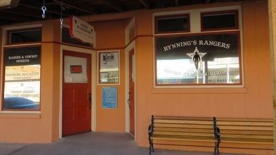
On North Morley Avenue, on the right when traveling south.
The Montezuma Hotel, sixty feet east of here, built in 1886, rebuilt twice, and closed in 1965, was the center of Nogales business and social life for more than half a century. The Office of owner George Christ, First U.S. Customs Collector of the . . . — — Map (db m27082) HM
The New Mexico and Arizona Railroad which served Patagonia, was built by the Santa Fe in 1881-82 and was operated after 1897 by the Southern Pacific. The last portion of this line, terminating at Patagonia, was abandoned in 1962.
The Patagonia . . . — — Map (db m24108) HM
On Calle Iglesia, on the right when traveling east.
Several Tubac churches have stood on this site. The first, a shelter built by Jesuit missionaries in the early 1700's, was administered from Tumacacori. About 1760 Captain De Anza built a chapel for presidio soldiers. A later church was visited by . . . — — Map (db m27143) HM
On Calle Iglesia, on the right when traveling east.
In 1789, Toribio Otero received the first land grant in this area in exchange for teaching school at his ranch. A school district was established in 1876 and in 1885 T. Lillie Mercer built this school, one of the earliest in Arizona. It was in use . . . — — Map (db m27142) HM
On Lewis Avenue (Business Route 40) at 5th Street, on the right when traveling west on Lewis Avenue.
The hotel opened March 1, 1907, and was built of steel and concrete in the Mission Style of Spanish architecture. The hotel covered a space of 420’ X 200’. Cost was approximately $115,000.
On the ground floor of the structure was the lunch room . . . — — Map (db m33499) HM
Built circa 1926-27
by the Arizona Department
of Transportation
This building constructed of Moenkopi Sandstone, has been listed on the National Register of Historic Places.
The Ash Fork Camp location was selected because it is a . . . — — Map (db m33443) HM
On Main Street (Arizona Route 89A) at First Avenue, on the left when traveling east on Main Street.
Before the Bartlett Hotel, the Grandview Hotel, a wooden structure built in 1895 stood here as the first two-story building in Jerome. It had rooms for dances, dining and sleeping. In 1898 the structure was destroyed by fire. The Bartlett Hotel was . . . — — Map (db m33166) HM
On Main Street (Arizona Route 89A) at Jerome Avenue, on the left when traveling east on Main Street.
This native stone and brick building was built in 1898. David Connor, proprietor, was an Irish-American who originally owned the Stone Saloon on the site of this hotel. In 1897 he added the second floor and called his building the Hotel Connor. . . . — — Map (db m33155) HM
On Main Street (Arizona Route 89A), on the right when traveling east.
The original Jerome Town Hall was built in the late 1800s. The town quickly outgrew the small space and by 1929 a bond had passed to enlarge the old brick building. New construction was to be of concrete. In addition to enlarging town hall, a police . . . — — Map (db m33145) HM
Near Hull Avenue near Diaz Street, on the right when traveling north.
Back in 1905, the town jail was in the basement of what was then the Tony Kauzlarich House below the Dicus and Wagner Garage. Louis St. James was the magistrate and conservator of the peace.
What is believed to be Jerome's 3rd jail was located . . . — — Map (db m71963) HM
On Main Street (Arizona Route 89A) at Verde Avenue, on the left when traveling east on Main Street.
You are standing at the second story entrance to what once was a three story primary school. The land was purchased, a bond was passed and construction began in 1913. It opened May 29, 1914 to graduate 3 seniors: Francis Lyons, Gertrude Rothermel . . . — — Map (db m33191) HM
On Main Street (Arizona Route 89A) at Jerome Avenue, on the left when traveling east on Main Street.
The mine museum, one of Jerome's oldest commercial buildings, was purchased by J.S. Hoover and A.C. Cordiner from G.A. Stoney in 1896. The building was destroyed in a fire in 1898. An architect from Los Angles built the present building with steel . . . — — Map (db m33157) HM
On Main Street (Arizona Route 89A), on the left when traveling east.
The New State Motor Company building was built of concrete in 1918 under the ownership of Dan Shea. A car dealership and show room were located upstairs and a garage downstairs. Inside the building an elevator delivered cars to the lower floor. A . . . — — Map (db m33151) HM
This saloon was built in 1899 to replace the original structure that was destroyed by fire. It operated as the Senate Saloon with a Chinese restaurant downstairs. It soon became the largest gambling establishment in the southwest. During prohibition . . . — — Map (db m33164) HM
On Main Street (Arizona Route 89A), on the right when traveling east.
This one-half story wood frame structure with corrugated sheet metal was built in the 1920's. It was the Reese and Amster White Garage and Machine Shop. Vehicles sold by Reese and Amster included the Chrysler 50, 60 and 70 and the Maxwell Car, which . . . — — Map (db m33150) HM
On Main Street (Arizona Route 89A), on the right when traveling east.
Built in 1917, the first floor of this four-story apartment, housed the Independent Meat Company. A passage was built from the cooler of the meat company up to the apartments to allow cool air to pass into them. Originally there were nine . . . — — Map (db m33190) HM
On Hampshire Avenue near Upper Gulch Road, on the right when traveling east.
The Gibson Market was originally built as a grocery store with an above apartment in 1917 by James and Ethel Hamilton. After Ethel's husband died in the flu epidemic of 1918, she was the sole proprietor until 1929. In 1919, Ethel married Myron L. . . . — — Map (db m33192) HM
On Main Street (U.S. 89A), on the left when traveling east.
In 1896, one of the first wooden structures built in Jerome occupied this site and was known as "The Saloon". The Saloon building survived two years before succumbing to fire, which destroyed most of Jerome in 1898. The structure was rebuilt only to . . . — — Map (db m33165) HM
On Gurley Street (Arizona Route 89) west of Cortez Street, on the right when traveling west.
Originally this was the site of A.G. Dunn's Butcher Shop, which provided fresh locally grown beef from Dunn's ranch. This was followed by Hubbard's drug store which was later owned by W.W.Ross. The drug store was purchased by Harry Brisley in 1899. . . . — — Map (db m20292) HM
Coles Bashford arrived in Prescott in 1864 and was the first President of the Territorial Legislature. In 1874, Coles, his brother Levi, and son William formed a partnership with Robert Burmister. The Bashford-Burmister Company became one of the . . . — — Map (db m18806) HM
On West Goodwin Street west of South Cortez Street, on the right when traveling east.
This Romanesque/Classical Revival building was constructed in 1895 and served as both a fire station (on the first floor) and the City jail (on the second). It is one of the two buildings facing the Courthouse Plaza that survived the fire of 1900. . . . — — Map (db m33090) HM
Colonel C. P. Head was in the hardware business in Prescott by about 1866. By 1875, Colonel Head was involved in several businesses including hardware, lumber and a hotel. He served in the territorial House of Representatives from Yavapai County for . . . — — Map (db m20296) HM
On North Cortez Street at East Willis Street, on the right when traveling north on North Cortez Street.
J. I. Gardner came to Prescott with a pack train in 1879 and opened his first mercantile store in 1883. The J. I. Gardner Store was built on this corner in 1890. Gardner's motto was "all goods guaranteed to be first class". They carried every type . . . — — Map (db m41960) HM
On South Cortez Street, on the right when traveling south.
With the exception of the Courthouse, the Knights of Pythias Building, also known as the Tilton Building, has always been the tallest building on the Plaza at 46 feet. It was dedicated on November 27, 1895, and is one of the few buildings that . . . — — Map (db m21625) HM
On Park Avenue near Coronado Avenue, on the left when traveling south.
In early 1908, the Prescott School Board decided that a new school was needed in Prescott. On July 12, 1908, a school bond election was held and approved by the voters 119-1. In August 1908, the three acre site on Park Avenue on the west side of . . . — — Map (db m33049) HM
The one hundred block of South Montezuma Street has long been known as "Whiskey Row" for the numerous saloons which once lined the street. As Prescott poet Gail Gardner once wrote of "Whiskey Row":
"Oh they starts her in at the Kaintucky bar, At . . . — — Map (db m20622) HM
On East Union Street at South Marina Street on East Union Street.
Originally a part of the Capitol Block, which was set aside in 1864 for a Territorial Capitol Building, the south half of the block was sold at auction. John Lawler, a miner, capitalist and real estate developer, bought the entire block and built a . . . — — Map (db m20618) HM
On East Gurley Street at South Alarcon Street, on the right when traveling east on East Gurley Street.
Three very prominent buildings once stood on East Gurley Street between Alarcon and Marina Streets – The Territorial Capital Building, Prescott High School and the Yavapai Club.
Originally, the property between Alarcon and Marina streets . . . — — Map (db m33095) HM
On Cortez Street at Gurley Street (Arizona Route 89), on the right when traveling north on Cortez Street.
The Prescott National Bank was organized by William Bashford, R.N. Fredericks and others in March, 1893. In October, 1900 Bank President Frank N. Murphy announced the construction of a new bank building on the "Old Wooster Block" at Prescott's . . . — — Map (db m27224) HM
Near East Gurley Street east of North Arizona Avenue.
Prescott was one of the first towns in Arizona to have a National Guard Unit. Companies B and C of the First Territorial Rifles were organized in Prescott in 1865 and Company M of the First Arizona Infantry was organized in 1910. Company M of the . . . — — Map (db m33136) HM
Near South Alarcon Street south of East Goodwin Street.
Prescott's modern public library was dedicated on May 18, 1975. However, the history of a public library in Prescott goes back to August 1895, when seven local ladies founded the Women's Club of Prescott (now the Monday Club). They gathered a . . . — — Map (db m52912) HM
On North Marina Street., on the right when traveling south.
In the fall of 1878 the Sisters of St. Joseph came to Prescott. Money was raised in the community for a hospital to be run by the sisters and by 1881 the hospital had been completed on North Marina Street. In June of 1891 construction was started . . . — — Map (db m21603) HM
On South McCormick Street south of Beach Avenue, on the right when traveling north.
George W. Curtis came to Prescott from California in 1864, and in 1867 purchased an interest in a sawmill. He purchased a building on Granite Creek on South McCormick Street, and he and his brother John enlarged and modified the building in 1878. . . . — — Map (db m33062) HM
On South Cortez Street at East Union Street on South Cortez Street.
The Goldwater Brothers, Morris and Michael, arrived in Arizona from California in 1876. They opened one of the area's first general merchandising stores on the southeast corner of Cortez and Goodwin (where City Hall is now located). Three years . . . — — Map (db m20616) HM
Near South Cortez Street south of East Goodwin Street (Arizona Route 89), on the right when traveling south.
The southeast corner of Goodwin and Cortez Street was the site of Howey's Hall, which was built on the first lot sold (for $175) in Prescott by James Howey in 1876. The Goldwaters had their first mercantile store here. It was later converted to an . . . — — Map (db m33092) HM
On East Gurley Street (Arizona Route 89) at South Cortez Street, on the left when traveling west on East Gurley Street.
The courthouse you see today, constructed in 1916 and listed in the National Register of Historic Places, is not the original one on this site. The first courthouse constructed on the Plaza, one of two city blocks set aside in 1864 for government . . . — — Map (db m18132) HM
On Gurley Street (Arizona Route 89) at Cortez Street, on the right when traveling east on Gurley Street.
A bank was an important asset to a new and growing community. Chartered by Solomon Lewis and M. W. Kales in 1877, the Bank of Arizona was the first business in the Arizona Territory devoted exclusively to banking. The partners built a two-story . . . — — Map (db m20295) HM
On East Gurley Street (Arizona Route 89) at Marina Street, on the left when traveling west on East Gurley Street.
Prescott's first library consisted of over 300 volumes brought to the Territory in 1864 by Secretary of State Richard C. McCormick. In 1870, a group of local women opened a reading room with 263 books collected from local citizens and out-of-town . . . — — Map (db m20814) HM
On East Gurley Street east of South Marina Street, on the right when traveling west.
The Day Octagon is the oldest known fired brick building in Arizona. Built in 1877 by Lowell and Crouch for Dr. Warren E. Day, it is significant as the first surgical hospital in Arizona Territory, where Dr. Day pulled teeth, delivered babies, . . . — — Map (db m33138) HM
On North Montezuma Street at West Willis Street, on the left when traveling north on North Montezuma Street.
Joseph and Margaret Ehle arrived in Prescott, Arizona Territory, on July 13, 1864 with their children, John Henry, Mary Jane, Amy E., Olive Joan, Sarah F. and Margaret Viola. Mr. Ehle helped to build the log Governor's Mansion (now part of Sharlot . . . — — Map (db m33133) HM
On South Montezuma Street (Arizona Route 89) at West Goodwin Street, on the right when traveling south on South Montezuma Street.
A disastrous fire on the night of July 14, 1900 changed the face of downtown Prescott. Starting in a room in the Scopel Hotel on the southwest corner of Goodwin and Montezuma Streets, the fire quickly hopped across Goodwin Street and proceeded to . . . — — Map (db m20811) HM
On West Gurley Street at North Granite Street, on the right when traveling west on West Gurley Street.
Completed in August 1901, the Mulvenon Building was one of the first buildings constructed after the fire of 1900. It replaced a one-story wood-frame saloon building which was destroyed in the fire. Built by William J. Mulvenon, who arrived in . . . — — Map (db m20615) HM
On South Montezuma Street, on the right when traveling south.
The exact age of Prescott's Palace Saloon is something of a puzzle. The first reliable documentation is an item from the September 21, 1877 Arizona Weekly Miner: "Mess'rs Shaw and Standefer have fitted up the Palace Saloon in the most superb . . . — — Map (db m21163) HM
On East Gurley Street east of South Alarcon Street, on the right when traveling west.
The first public school in Prescott was opened in 1867. In 1876 a four-room brick public school building was erected here. It was known as the "Prescott Free Academy". In 1903 that building was torn down and replaced by Washington School. Washington . . . — — Map (db m33094) HM
On South 1st Avenue south of East First Street, on the right when traveling south.
Built by John Gandolfo, this brick landmark served as a 635 seat theater and vaudeville house, a WW II USO canteen and was a center of community activity from 1917 to 1950. The third floor ballroom was destroyed by fire in 1925.
Dedicated . . . — — Map (db m28987) HM
On West 2nd Street east of South 1st Avenue, on the left when traveling east.
John Ghiotto, native of Genoa, came to Yuma in 1890 to work in the Gandolfo store. He went into business for himself and had a chain of four small groceries. His brick home is typical of middle class housing of this period.
Dedicated December . . . — — Map (db m29004) HM
On South Avenue B south of West 5th Street, on the right when traveling north.
In Commemoration
Of the
125th Anniversary of the Founding
of
Immaculate Conception Parish
1866 – 1991
Celebrated on the Feast of the Immaculate Conception
December 8, 1991
Most Rev. Manuel D. Moreno, D.D.
Bishop of . . . — — Map (db m29024) HM
On West 2nd Street east of South 1st Avenue, on the left when traveling east.
This turn of the century adobe is an example of middle-class housing in Yuma. It is also a fine example of the Anglicized Sonoran style building tradition.
Dedicated December 1999, by the City of Yuma
for the preservation of our heritage. . . . — — Map (db m29003) HM
This adobe building was constructed in 1872 as an office for the Fort Yuma Quartermaster Depot. It replaced a room in a corner of the depot storehouses where, according to Captain J. G. C. Lee, Quartermaster, ". . .the noise of the arrivals and . . . — — Map (db m29000) HM
A steam pump located at the edge of the river propelled muddy Colorado River water through pipes to an elevated holding tank constructed of local rock and mortar with a wood shingle roof to decrease evaporation. Sediment fell to the bottom of the . . . — — Map (db m29001) HM
On South Main Street south of West 4th Street, on the left when traveling south.
The best preserved 19th century brick building in Yuma. One of the few structures to survive the flood of 1916. Across the street from the Southern Pacific Roundhouse, it offered groceries, sundries, and a saloon for railroad employees. . . . — — Map (db m29019) HM
On South Main Street south of East 3rd Street, on the right when traveling south.
United States
Post Office
has been placed on the
National Register
of Historic Places
The United States Post Office is a two-story
building of reinforced concrete faced
with native Arizona stone. The design
has strong Beaux-Arts roots, . . . — — Map (db m191672) HM
On West 2nd Street east of South 1st Avenue, on the left when traveling east.
This early commercial block was built by Jose Maria Venegas as a storehouse/dry goods outlet. The sheltered arcade is typical of southwest design of the period. The family also owned the Yuma Steam laundry in this neighborhood.
Dedicated . . . — — Map (db m29005) HM
On West 1st Street west of North Second Avenue, on the right when traveling west.
Built in classic Spanish Colonial Revival style on high ground overlooking the Colorado River, it has served as the traditional seat of municipal government.
Dedicated December 1999, by the City of Yuma for the preservation of our heritage. . . . — — Map (db m28985) HM
259 entries matched your criteria. Entries 201 through 259 are listed above. ⊲ Previous 100