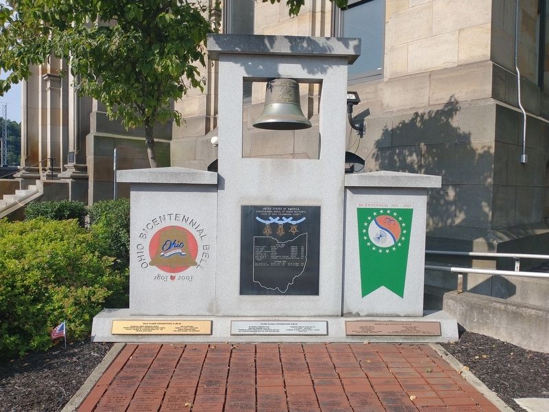
Civil War
Barrick, Jessie T. Second Lieutenant Tennessee 1863
Davis, Joseph Corporal Tennessee 1864
Caunt, John C. Private Tennessee 1864
Greenawalt, Abraham Private Tennessee 1864
Renninger, Louis Corporal Tennessee 1863
Surles. . . . — — Map (db m204442) WM
Southeast of this point are the Big and Little tunnels. They were links in the 73-mile Sandy and Beaver Canal which connected the Ohio River with the Ohio and Erie Canal. Shifts of Irish laborers worked night and day with hand drills and blasting . . . — — Map (db m66538) HM
Believed to have been constructed in 1866, this facility is one of the largest of its kind in the nation. The complex of 200 ovens was erected by the Leetonia Iron and Coal Company, later known as the Cherry Valley Iron Works, to supply fuel for . . . — — Map (db m221403) HM
Church Hill Bridge Road. This covered bridge, over Middle Run, Elkrun Township, Columbiana County, is the shortest covered bridge in the United States still standing on a once-used public highway, having a clear span of 19 feet and 3 inches. . . . — — Map (db m206008) HM
In July 1863, Confederate General John H. Morgan led a force of 2,000 cavalrymen across southern Ohio. Morgan's force entered Ohio from Indiana on July 13. A chase ensued as Union cavalry pursued Morgan's men across twenty Ohio counties. Most of . . . — — Map (db m13383) HM
Near this site on September 30, 1785, Thomas Hutchins, first Geographer of the United States, drove a stake: This was the "Point of Beginning" of the Geographer's Line for the survey of the first "Seven Ranges" of six-mile square townships in . . . — — Map (db m44155) HM
About a mile south in St. Paul's Cemetery, the Reverend Father Edward J. Fenwick, "Pioneer Apostle of Ohio," organized the first Catholic parish in northern Ohio. The first mass was celebrated in the log house of Daniel McCallister. A century and a . . . — — Map (db m66536) HM
General John Hunt Morgan, CSA. On this site once stood the Ohio Penitentiary, which was built in 1834 and operated through 1984. Incarcerated here in July 1863 was Confederate General John Hunt Morgan, a cavalry commander known as the . . . — — Map (db m12966) HM
The Sandy & Beaver Canal was constructed during the great 1827 to 1850 canal building era that transformed Ohio from a wilderness into a prosperous center of commerce, agriculture, and industry. Canals provided the first convenient and affordable . . . — — Map (db m293098) HM
In 1915 the city of Alliance, Ohio enlarged its water supply source by purchasing land and damming streams in Knox Twp., Columbiana County, at Westville, Ohio. The waters of the new Westville Reservoir would inundate the private Westville Colored . . . — — Map (db m207181) HM
Built as a blockhouse in 1774–78 by John Mason. It was a settler’s refuge in Revolutionary days. The site of the fort was nearby. Later rebuilt on Main Street as a dwelling. — — Map (db m134168) HM
First Paper Mill
The first paper mill in Ohio and the Northwest Territory was established in the valley below in 1807 by John Coulter of Virginia, Jacob Bowman and John Beaver of Pennsylvania. The mill was in St. Clair Township on the East . . . — — Map (db m62960) HM
Chase County, named after Salmon P. Chase, who was a United States Senator from Ohio and Chief Justice of the Supreme Court of the United States, was organized in 1859 in the Kansas Territory.
James Fisher, from Columbiana County, Ohio was the . . . — — Map (db m45683) HM
General John Hunt Morgan led a force of 2,000 Confederate cavalrymen into Meigs County during a raid north of the Ohio River. More than 50,000 Union troops and militia had been in pursuit of Morgan across Ohio. Near this site on July 18. 1863, . . . — — Map (db m293594) HM
The Reihle family once farmed what is now Pike Lake State Park. Auselein Reihle lost her son and husband amidst the raging Civil War in 1864. A Union soldier mysteriously appeared at her property days after she heard of her husband's death. Wounded . . . — — Map (db m280784) HM WM
The history of the earth is written in the rocks. In Ohio, nearly 500 million years of time are recorded in our bedrocks, reflecting the coming of inland seas, the upheaval of mountain ranges and the birth and death of vast swamps. By reading these . . . — — Map (db m55084) HM
The Supreme Court of the state of Ohio held one of its first sessions in the House of Matthias Lower, the temporary seat of justice for Columbiana County, at this site on the 14th day of June 1803 Samuel Huntington and William Spriggs presided as . . . — — Map (db m175124) HM
After a skirmish with Union forces on July 26, 1863, Brigadier General John Hunt Morgan regrouped the several hundred Confederate raiders who remained with him and turned east. Morgan's route down this valley was aimed toward East Liverpool on the . . . — — Map (db m173479) HM
Side A:Teegarden-Centennial Covered Bridge
The Teegarden-Centennial Covered Bridge, constructed primarily of white oak is of Multiple King Post design spanning 67 feet. It was built nearly 100 years after the birth of the nation. . . . — — Map (db m66539) HM
Arriving in 1853, the Central Ohio Railroad called this place “Kirkersville Station,” and it was later changed by stationmaster James Outcalt, who renamed the town Outville after himself. As rail traffic increased in Ohio, a successor . . . — — Map (db m16712) HM
(front)
Envisioned as a rural cemetery with careful attention to landscaping design and symmetrical lots, the Riverview Cemetery was established in 1883 on forty acres of land. The chapel was a gift to Riverview from the Grand Army of the . . . — — Map (db m49715) HM
From Canal Commerce to Pioneer Charm
In the 1800s, the Sandy and Beaver Canal transformed this quiet valley into a busy trade Route, with 90 locks and 30 dams stretching across 73 miles. Gaston's Mill, built in 1837, harnessed the energy of . . . — — Map (db m293103) HM
Side A: Morgan's Raid Route
General John Hunt Morgan of Kentucky led a force of Confederate calvarymen into Meigs County during a forty-six-day raid north of the Ohio River. The advance forces burned Benjamin Knight's carding mill and . . . — — Map (db m30456) HM
On July 23, 1863, General John Hunt Morgan entered Guernsey County with 600 Confederate cavalrymen, the remnant of a 2,000-man diversionary raiding force that had traversed Kentucky, Indiana, and southern Ohio. Morgan’s forces halted in Old . . . — — Map (db m1036) HM
(side A)
Mahoning County was created in 1846 by combining townships from southern Trumbull and northern Columbiana counties. Canfield engaged in competition with several surrounding communities for the new county seat, and its success was . . . — — Map (db m41232) HM
LAKE PLAINS
■ A narrow strip of land along the Lake Erie coast in northeastern
Ohio, it broadens significantly west of Cleveland.
■ Once the bottom of a much larger ancient lake known as
Lake Maumee, this region is an . . . — — Map (db m303183) HM
LAKE PLAINS
■ A narrow strip of land along the Lake Erie coast in northeastern
Ohio, it broadens significantly west of Cleveland.
■ Once the bottom of a much larger ancient lake known as
Lake Maumee, this region is an . . . — — Map (db m302226) HM
General John Hunt Morgan led a force of 2,000 Confederate cavalrymen
into Meigs County during a raid north of the Ohio River. More
than 500,000 Union troops and militia pursued Morgan across
Ohio. Colonel Basil Duke wrote that while passing near . . . — — Map (db m122850) HM
General John Hunt Morgan led a force of
2,000 Confederate cavalrymen into Meigs
County on July 18, 1863, during a forty-six day
raid north of the Ohio River. After a skirmish
with the 23rd Ohio Infantry, the Confederates
paused to drink and . . . — — Map (db m108185) HM
LAKE PLAINS
■ A narrow strip of land along the Lake Erie coast in northeastern
Ohio, it broadens significantly west of Cleveland.
■ Once the bottom of a much larger ancient lake known as
Lake Maumee, this region is an . . . — — Map (db m286210) HM
By Gayleen Gindy
In my last article we finished the histories about our downtown Main Street buildings and businesses, ending with today's Key Bank building, located on the northeast corner of Main and Monroe streets.
Now I would like to tell . . . — — Map (db m293058) HM
In May 1879, S.J. and D.W. Firestone opened a private bank under the name Firestone Bros. Bankers. The bank moved to this location in 1883. In 1911, the bank was incorporated as a state bank and the name was changed to The Firestone Bank. The . . . — — Map (db m164130) HM
This 42-foot-long covered bridge spans a small stream on Echo Dell Road in Beaver Creek State Park. In the 1870s, the bridge stood over the Middle Run River in Columbiana County. It was converted to a storage shed and moved twice by township . . . — — Map (db m293100) HM
This stone marks the spot where the Confederate raider Gen. John H. Morgan surrendered his command to Maj. George W. Rue July 26, 1863 and is the farthest point north ever reached by any body of Confederate troops during the Civil War. — — Map (db m36094) HM
[Mural is on both sides of brick walls on the northern end of town that lie on both sides of the street:]
Wellsville Revitalization Committee Picnic
"Riverside"
Presbyterian Church, USA
525 Riverside Ave.
Founded April 5, 1831 . . . — — Map (db m156060) HM WM
Thin black lines indicate changes in relevance. Between each pair of lines entries are ordered geographically but all have the same relevance.
* Inflectional forms of words are their plurals, singulars, and possessives as well as gramatical tenses and similar variations.