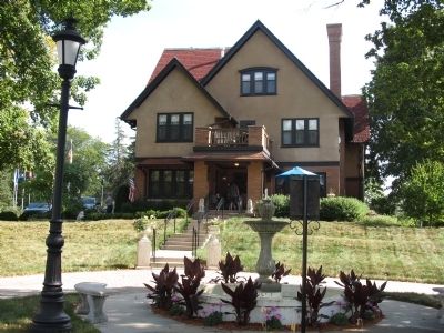
This stately mansion was built be August and Mary (Schott) Westphal in 1913, on a triangular lot overlooking downtown historic Hartford. The home of brick and stucco is English Tudor style. The interior is finished with golden oak and birch . . . — — Map (db m67910) HM
This home was built on the original homestead of 40-acres in Section 20, Town of Jackson, Washington County, Wisconsin. The land was purchased from the United States government on April 11, 1846, by Jacob Moersfelder, who later deeded the parcel to . . . — — Map (db m72904) HM
Lohr’s Gas Station was built in 1928 by Lawrence Lohr on the front lawn of his residence at 158 Branch Street. It was operational as a gas station when $1.00 could purchase 5-8 gallons of gas.
The historic feature of this building is the . . . — — Map (db m67908) HM
In 1883, Willard R. Amidon built this Queen Anne style home for his wife Laura. This home served as the family residence until Laura’s death in 1944. The house has the original fieldstone foundation and retains many original features. Many . . . — — Map (db m67909) HM
The Backhaus Family emigrated from Prussia to America in 1850 and purchased this 135-acre farm, parcel by parcel, from 1853-1864. They lived in an unfinished log cabin that has long since been replaced by this Victorian, 3-story cream city brick . . . — — Map (db m48259) HM
This 1904 Queen Anne Victorian home was originally owned by N. Edward Hausmann, M.D., son of William Hausmann, M.D. It is built in a four-square design and features a large rounded turret on the Northwest corner of the home. The third level was . . . — — Map (db m72920) HM
This Queen Anne Victorian home, with a gabled roof and large wrap around porch, was built in 1894 by Louis Brandt, local carpenter/contractor, and was originally owned by William Hausman, M.D. The porch has lattice work design with spindle banister . . . — — Map (db m72919) HM
This Square, known as The Park, was given to Washington County in 1853 as a site for county buildings for the use and benefit of the county forever. Donors were William Wightman, Byron Kilbourn, James Kneeland, E.B. Wolcott, and their wives. This . . . — — Map (db m35205) HM
The first strictly rural electric power line in the United States was built in 1919 by West Bend Heating and Lighting Company, which was founded in 1907 by Adam Kuehlthau. It was 24 miles long and served 57 farmers in the townships of West Bend, . . . — — Map (db m77250) HM
Lizard Mound Park is one of the best preserved and most diverse prehistoric effigy mound archeological sites in the state. It contains numerous mounds (A.D. 650-1300) in conical, linear, bird, panther, and lizard shapes. Originally known as the . . . — — Map (db m30121) HM
Built in 1847 by Densmore W. Maxon, a Yankee surveyor and member of the first Wisconsin State Legislature, who constructed a dam and sawmill and platted Cedar Creek. The east wing housed the first village post office. The Greek Revival style house . . . — — Map (db m77006) HM
In West Bend’s early days, this plot was a community gathering place. For over 90 years, the Triangle and the building which stood there were at the center of business, social and political life, and served as a meeting place for the old settlers. . . . — — Map (db m35208) HM
This block was deeded to Washington County on May 2, 1853, by the Wightman, Kilbourn, Kneeland, and Wolcott families to locate and erect county buildings. The original courthouse, constructed in 1854, was relocated to Main Street when the 1889 . . . — — Map (db m35206) HM
Black's Fort History
from History of Southwest Virginia, 1746-1786
Washington County 1777-1870
by
Lewis Preston Summers
In 1760, what was to become Abingdon received its first name, Wolf Hills, from Daniel Boone after his hunting party was . . . — — Map (db m210058) HM
The Saxonia House, a 72-foot by 32-foot rare example of German fachwerkbau (half-timber construction) architecture, is one of the largest buildings of its kind in Wisconsin. In November 1855 the new structure was christened as a brewery, a residence . . . — — Map (db m48260) HM
Minnesota Territory 1849 – 1858
On March 3, 1849, during his last hours in office, President James K. Polk signed a bill adding a new name to the American political landscape – Minnesota Territory. A vast land, it stretched from . . . — — Map (db m43908) HM
Have you ever wondered?
In a city with nearly equal numbers of Black and white residents, why is Ward 3's population 70% white and 8% Black?
Since at least the 1700's, Black people have lived and thrived in the area, . . . — — Map (db m259716) HM
St. Peter's Catholic Church was established in 1846. The first structure was a log church built in 1855. The present structure was built in 1861. The church is an outstanding example of fieldstone construction featuring an unusual half-octagonal . . . — — Map (db m48261) HM
The Cedar Lake Yacht Club was founded in 1899 and is situated on Big Cedar Lake, the largest lake in Washington County. Although there have been many renovations and additions, the original field stone structure still stands.
The Cedar Lake . . . — — Map (db m48256) HM
Harlow Bolton formed a partnership with Asa Varney and William H. Willis in 1853 to build the mill, along with a mill pond. The mill, known for many years as the Reliance Roller Mills, was the first business in Boltonville, built in 1854.
Wheat . . . — — Map (db m48257) HM
James Kneeland, one of the founders of West Bend, purchased this plot of land in the early 1840s. This 2 ½ story side gabled cream city brick building was erected in 1858 and is one of the oldest buildings in West Bend.
In 1860, the . . . — — Map (db m70013) HM
Stephen F. Mayer (1854-1935) was a prominent resident of West Bend, held numerous elected offices and leadership positions at various levels of government and local businesses, and established several businesses and organizations that still exist . . . — — Map (db m70015) HM
The United States Government Land Grant transfer from Byron Kilbourn, et al to Caroline P. Brown took place March 10, 1847.
This front gable home was typical of many houses built between 1850 and 1925. This property is part of the original plat . . . — — Map (db m143959) HM
All of the land seen from this bridge and beyond is part of millions of acres ceded under an 1837 treaty between Ojibwe and Dakota bands and the United States government. The acreage contained vast tracts of the prized white pine that grew north of . . . — — Map (db m233476) HM
Background Overshadowed by the Battle of Antietam (near Sharpsburg), which took place three days later and resulted in a loss of 23,000 men, the Battle of South Mountain nevertheless played a crucial role in determining the outcome of . . . — — Map (db m129047) HM
Home to the hamlets of Houlton and Burkhardt, The Town of St. Joseph is a unique, rural, and beautiful place. The area's ample natural resources include bluff lands, streams, wetlands, woodlands, dairy farms, and rolling agricultural fields. The . . . — — Map (db m239280) HM
Dedicated to the
Soldiers and Sailors of the
United States
Enlisting or Residing in
Washington County
———
Erected by the Citizens of
Washington County
1916
center panel
Minnesota
Alcorn James 2nd Cav. •
Barrisford . . . — — Map (db m72153) WM
Thin black lines indicate changes in relevance. Between each pair of lines entries are ordered geographically but all have the same relevance.
* Inflectional forms of words are their plurals, singulars, and possessives as well as gramatical tenses and similar variations.