On Main Street south of 3rd Street, on the left when traveling south.
With the faith and courage of
their forefathers who made
possible the freedom of these
United States
The Boy Scouts of America
dedicate this replica of the
Statue of Liberty as a pledge
of everlasting fidelity and
loyalty . . . — — Map (db m72390) HM
On 12th Street south of Grand Avenue, on the right when traveling south.
With the faith and courage of
their forefathers who made
possible the freedom of these
United States
The Boy Scouts of America
dedicate this replica of the
Statue of Liberty as a pledge
of everlasting fidelity and
loyalty . . . — — Map (db m72403) HM
On West Main Street at Court Street, on the left when traveling west on West Main Street.
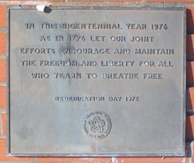
With the faith and courage of their forefathers who made possible the freedom of these United States The Boy Scouts of America dedicate this copy of the Statue of Liberty as a pledge of everlasting fidelity and loyalty The Crusade to . . . — — Map (db m235957) HM
On 6th Street west of Airport Road/SW 40th Avenue, on the right when traveling west.
[Panel] 1 The B-29 Memorial
Honoring the Past...
Educating the Future
The B-29 Memorial was built to honor the sacrifices made by people in the past to ensure freedom for future generations. Until the 1990s, the Great Bend Army Air . . . — — Map (db m69240) HM WM
On Central Avenue (State Highway 254) at Star Street, on the left when traveling west on Central Avenue.
With the faith and courage of
their forefathers who made
possible the freedom of these
United States
The Boy Scouts of America
dedicate this replica of the
Statue of Liberty as a pledge
of everlasting fidelity and
loyalty . . . — — Map (db m56179) HM
On Main Street at Chestnut Street, on the left when traveling south on Main Street.
With the faith and courage of
their forefathers who made
possible the freedom of these
United States
The Boy Scouts of America
dedicate this replica of the
Statue of Liberty as a pledge
of everlasting fidelity
and loyalty . . . — — Map (db m47713) HM
On Main Street at 13th Street, on the left when traveling north on Main Street.
With the faith and courage of
their forefathers who made
possible the freedom of these
United States
The Boy Scouts of America
dedicate this replica of the
Statue of Liberty as a pledge
of everlasting fidelity and
loyalty . . . — — Map (db m95332) HM
On 8th Street at Pine Street, on the left when traveling north on 8th Street.
With the faith and courage of
their forefathers who made
possible the freedom of these
United States
The Boy Scouts of America
dedicate this copy of the
Statue of Liberty as a pledge
of everlasting fidelity and
loyalty . . . — — Map (db m65855) HM
Near Interstate 70 at milepost 301 at Henry Drive, on the left when traveling west.
Model. M65 280 m.m. Weight. 42,500 lbs. Length. 42 feet (1) One of only (3) three in existence, the other two are located at Ft. Sill, Oklahoma and the U.S. Army Ordinance Center in Aberdeen, Maryland. It was placed in service November 17, 1952 . . . — — Map (db m168310) HM
On Johnson Drive east of Newton Street, on the right when traveling east.
With the faith and courage of
their forefathers who made
possible the freedom of these
United States
The Boy Scouts of America
dedicate this replica of the
Statue of Liberty as a pledge
of everlasting fidelity and
loyalty . . . — — Map (db m93455) HM
On Main Street at D Avenue (U.S. 54/400), on the right when traveling north on Main Street.
With the faith and courage of
their forefathers who made
possible the freedom of these
United States
The Boy Scouts of America
dedicate this copy of the
Statue of Liberty as a pledge
of everlasting fidelity and
loyalty
The . . . — — Map (db m62635) HM
On Main Street at 28th Street, on the right when traveling west on Main Street.
With the faith and courage of
their forefathers who made
possible the freedom of these
United States
The Boy Scouts of America
dedicate this replica of the
Statue of Liberty as a pledge
of everlasting fidelity and
loyalty . . . — — Map (db m93368) HM
On 5th Street at Shawnee Street, on the right when traveling north on 5th Street.
With the faith and courage of
their forefathers who made
possible the freedom of these
United States
The Boy Scouts of America
dedicate this replica of the
Statue of Liberty as a pledge
of everlasting fidelity and
loyalty . . . — — Map (db m71710) HM
In honor of Veterans
who served in
Lebanon and Grenada
August 24, 1981 - July 31, 1984
Panama
December 20, 1989 - January 31, 1990 — — Map (db m49833) WM
With the faith and courage of
their forefathers who made
possible the freedom of these
United States
The Boy Scouts of America
dedicate this replica of the
Statue of Liberty as a pledge
of everlasting fidelity and
and loyalty . . . — — Map (db m61053) HM
On 8th Street at Read Avenue, on the right when traveling west on 8th Street.
With the faith and courage of
their forefathers who made
possible the freedom of these
United States
The Boy Scouts of America
dedicate this copy of the
Statue of Liberty as a pledge
of everlasting fidelity and
loyalty . . . — — Map (db m96983) HM
On Pennsylvania Avenue (U.S. 75) at Locust Street, on the right when traveling north on Pennsylvania Avenue.
[The original marker has been removed]
Dedicated Feb. 17, 1952
by
Boy Scouts of America
Rededication by
President Gerald R. Ford
in memory
Gary W. Moffatt
Coordinator
Independence Police
Reserve Unit
Assistant Coordinator . . . — — Map (db m61439) HM
Near U.S. 281 at Northeast 40th Street (Flint Road), on the left when traveling north.
The F-4 was first developed for the US Navy in 1958 and entered service in 1961. In 1963, the USAF received a modified version of the Navy F-4B, called the F-4C. It was equipped to deliver an assortment of air-to-ground and air-to-air missiles, . . . — — Map (db m229986) HM
On 1st Street (U.S. 54/400) at Haskell Street, on the right when traveling east on 1st Street.
With the faith and courage of
their forefathers who made
possible the freedom of these
United States
The Boy Scouts of America
dedicate this replica of the
Statue of Liberty as a pledge
of everlasting fidelity and
loyalty . . . — — Map (db m65057) HM
On Main Street (U.S. 183) at 4th Street, on the left when traveling south on Main Street.
With the faith and courage of
their forefathers who made
possible the freedom of these
United States
The Boy Scouts of America
dedicate this replica of the
Statue of Liberty as a pledge
of everlasting fidelity and
loyalty . . . — — Map (db m95333) HM
On Lincoln Street south of 4th Street, on the left when traveling north.
With the faith and courage of
their forefathers who made
possible the freedom of these
United States
The Boy Scouts of America
dedicate this copy of the
Statue of Liberty as a pledge
of everlasting fidelity and
loyalty . . . — — Map (db m95331) HM
On Ash Street at 10th Street, on the right when traveling west on Ash Street.
The M60 Main Battle Tank was developed to take the place of the aging M48 Patton Tank. It began production in 1959 and included an improved 105mm Main gun instead of the 90mm and a 750 cu. in. diesel engine instead of the gas engine of the . . . — — Map (db m57174) HM WM
On Kenwood Park Drive at Mulberry Street, in the median on Kenwood Park Drive.
With the faith and courage of
their forefathers who made
possible the freedom of these
United States
The Boy Scouts of America
dedicate this copy of the
Statue of Liberty as a pledge
of everlasting fidelity and
and . . . — — Map (db m92191) HM
With the admission of Alaska in 1959 and Hawaii in 1960, the present fifty-star flag came into being. Like other flags of our nation, the fifty-star flag has seen the varied conditions that can beset a dynamic association of peoples. Under it, the . . . — — Map (db m56971) HM
On Douglas Avenue, on the right when traveling east.
With the faith and courage of
their forefathers who made
possible the freedom of these
United States
The Boy Scouts of America
dedicate this replica of the
Statue of Liberty as a pledge
of everlasting fidelity and
loyalty . . . — — Map (db m60622) HM
On Kansas Avenue (Business U.S. 83) at 5th Street, on the right when traveling north on Kansas Avenue.
With the faith and courage of
their forefathers who made
possible the freedom of these
United States
The Boy Scouts of America
dedicate this replica of the
Statue of Liberty as a pledge
of everlasting fidelity and
loyalty . . . — — Map (db m88499) HM
On 37th Street at Garfield Street, on the left when traveling west on 37th Street.
Main marker:
Dedicated in Memory of Major Willard G. Palm who died while serving his country
1921 - 1960
Major Willard G. Palm and his fellow crew members *Maj. Eugene E. Posa, *Capt. Oscar L. Goforth, *Capt. Dean B. Phillips, Capt. . . . — — Map (db m20547) WM
On SW Harrison Street at SW 8th Avenue, on the left when traveling south on SW Harrison Street.
With the faith and courage of
their forefathers who made
possible the freedom of these
United States
The Boy Scouts of America
dedicate this copy of the
Statue of Liberty as a pledge
of everlasting fidelity and
loyalty . . . — — Map (db m54603) HM
On 4th Avenue at Broadway, on the left when traveling west on 4th Avenue.
With the faith and courage of
their forefathers who made
possible the freedom of these
United States
The Boy Scouts of America
dedicate this copy of the
Statue of Liberty as a pledge
of everlasting fidelity and
loyalty . . . — — Map (db m95334) HM
On C Street at 3rd Street, on the right when traveling north on C Street.
With the faith and courage of
their forefathers who made
possible the freedom of these
United States
The Boy Scouts of America
dedicate this replica of the
Statue of Liberty as a pledge
of everlasting fidelity and
loyalty . . . — — Map (db m81059) HM
On Fort Campbell Blvd at Pennyfile Parkway (U.S. 169), on the right when traveling north on Fort Campbell Blvd.
Dedicated to the 248 Fort Campbell soldiers who died on December 12, 1985 at Gander, Newfoundland while returning from a peacekeeping mission in the Sinai. Presented in honor of all soldiers who serve at Fort Campbell, and in recognition of the . . . — — Map (db m248587) HM WM
Near Minuteman Parkway at West Frankfort Connector.
The Harrodsburg Tankers, then known as the 38th Tank Company, comprised of a Kentucky Army National Guard unit stationed in Harrodsburg who were called to active duty prior to World War II. The Kentucky Guardsmen landed on the Philippines on . . . — — Map (db m161765) HM
On Moscow Street (State Highway 94), on the right when traveling west.
Born in Hickman, Mr. Stahr became one of the towns most decorated citizens. Having studied in England as a Rhodes Scholar, Mr. Stahr went on to become President John F. Kennedy's selection as Secretary of the Army in 1961. During his tenure, the . . . — — Map (db m18448) HM
On South Crums Lane at Clyde Drive, on the right when traveling east on South Crums Lane.
Civil Rights Struggle, 1954
Louisville suburbs were racially segregated when African Americans Andrew and Charlotte Wade moved to Rone Court on May 15, 1954, two days before the Supreme Court condemned school segregation. Neighbors burned a . . . — — Map (db m161674) HM
On Main Street at Webb Street, on the right when traveling east on Main Street.
(Side One)
Pilot — Spy — Hero
Francis Gary Powers and the “U-2 Incident” catapulted activities of the United States into world view. This Burdine native, with other pilots directed by CIA, flew U-2’s . . . — — Map (db m97162) HM
On Main Street at Front Street, on the left when traveling north on Main Street.
Lieutenant Commander Benjamin Thomas Pugh October 21, 1020 — December 18, 1951
Lieutenant Commander Tom Pugh, Navy pilot, served on the aircraft carrier USS Valley Forge (CV-45)(VG-194) during the Korean War and was killed when his . . . — — Map (db m180480) HM WM
On South Water Street at Kentucky Avenue, on the left when traveling south on South Water Street.
Urgency was the order of the day, as construction of the Paducah Gaseous Diffusion Plant, TVA's Shawnee Steam Plant, and Electric Energy Inc.'s Joppa, Il Steam Plant all began early in 1951. Recognizing the importance to national security, workers . . . — — Map (db m48696) HM
Near Range Road, 0.1 miles north of Shreveport Road.
General Joseph James Nazzaro was born and raised in the shadows of the skyscrapers of New York City. Not too many years later, General Nazzaro would soar over the tops of those skyscrapers and go on to command some of this nation's mightiest air . . . — — Map (db m109691) WM
Near Range Road, 0.1 miles north of Shreveport Road.
Lewis Elton Lyle, a native of Pine Bluff, Arkansas and a graduate of Ouachita College, earned his wings in the 41-I class at Brooks Field, Texas. Assigned to the 303rd Bombardment Group upon activation of the 8th Air Force, he and his crew flew his . . . — — Map (db m109687) HM WM
Near Chenault Boulevard south of North Claiborne Avenue (State Highway 39), on the right when traveling south.
Type: 57 mm Anti-Aircraft Gun Weight: 10,273 lbs (5.1 tons) Rate of Fire: 105-120 rounds per minute Range: 19,685 ft (3.72 miles) Ammunition: 57x348SR caliber High Explosive and Armor Piercing Crew: 7The Type 59 is the Chinese Variant of the Soviet . . . — — Map (db m162916) HM
On Angela Street, 0.3 miles south of North Claiborne Avenue (State Highway 39), on the right when traveling south.
The Douglas A-26 Invader (designated B-26 between 1948-1965) was a single-pilot, twin-engine light bomber and attack aircraft built by Douglas Aircraft during World War II that also saw service during several of the Cold War's major conflicts. It . . . — — Map (db m160440) HM
On England Drive, on the left when traveling east.
The 23d Tactical Fighter Wing accepted its first A-10 Thunderbolt II in December 1980. Nicknamed The Warthog by its pilots, the A-10 was designed to provide close air support for ground forces. One of the most advanced features of the A-10 was its . . . — — Map (db m10110) HM
On England Drive, on the left when traveling east.
When the 23d Tactical Fighter Wing came to England AFB in 1972, the Flying Tigers flew the A-7D Corsair II attack aircraft. For seven months in 1973, A-7 aircraft from the 74th Tactical Fighter Squadron of the 23 TFW deployed to Thailand to support . . . — — Map (db m10111) HM
On England Drive, on the left when traveling east.
The Flying Tigers flew the F-86, one of the first swept-wing jet fighters, in the early 1950s. Known as the 23rd Fighter Interceptor Group, the unit provided air defense for the Northeastern United States while stationed at Presque Isle AFB, Maine. . . . — — Map (db m10112) HM
On England Drive, on the left when traveling east.
Relocated from Bringhurst Park and unveiled on 25 April 1992 during a 391st FBS homecoming, it has that squadron's markings, its operations officer as pilot, its weapons NCOIC as crew chief.
This airplane is dedicated to all the ‘cold . . . — — Map (db m10107) HM
Near U.S. 90 west of Silo Road, on the left when traveling west.
This plane’s last flight was into Memphis, TN. It was towed by truck through Memphis to a rock quarry on the Mississippi River. There, it was loaded onto a rock barge and brought to Morgan City. Once there, it was crane lifted off of the barge and . . . — — Map (db m93563) HM
In 1982, ten year old Samantha Smith wrote a letter to Yuri Andropov, the leader of the Soviet Union asking, "Why do you want to go to war with the United States?" Mr. Andropov's reply to that letter, his invitation for Samantha to visit, and her . . . — — Map (db m111036) HM
In memory of those who lost their lives in the B-52 crash of 24 Jan 1963.
Lt.Col. Joe S. Simpson Jr. Maj. William W. Gabriel Maj. Herbert L. Hansen Maj.Robert J. Hill Maj. Robert J. Morrison Capt. Charles G. Leuchter T-Sgt. Michael F. O'Keefe . . . — — Map (db m95834) HM
On Westernport Road, 0.2 miles north of Pine Swamp Road, on the left when traveling north.
Near this site, at 1:42 am on January 13th 1964, a B-52 bomber, call sign "Buzz One Four", crashed during a blizzard. The plane, with a crew of five, was armed with two 9-megaton nuclear weapons. Four of the five crew members ejected from the plane. . . . — — Map (db m96446) HM
Near Taylor Avenue (Maryland Route 435) north of Melrose Street, on the right when traveling south.
"Not for self, but for country" is the motto of the USNA Class of 1966—it exemplifies the tie that eternally binds together our Class, a graduate's branch of service, the Naval Service as a whole.
As a Class, we were forged in the crucible . . . — — Map (db m127933) HM WM
On 6th Armored Cavalry Road at Mapes Road, on the left when traveling south on 6th Armored Cavalry Road.
As the Cold War intensified in the late 1940s, security of the nation's Capital became a major concern of Defense Department planners. To protect the Capital, a ring of conventional and nuclear weapons was established around Washington, D.C. As part . . . — — Map (db m19643) HM
Near Colony Seven Road, 0.1 miles west of Canine Road. Reported missing.
[Panel 1:] The EA-3B Skywarrior was in service for more than three decades in the U.S. Navy’s secret reconnaissance war against the Soviet Union and the Warsaw Pact. Conceived at the dawn of th Cold War as an aircraft carrier-based nuclear . . . — — Map (db m17025) HM
On Colony Seven Road, 0.1 miles west of Canine Road, on the right when traveling west. Reported missing.
On September 2, 1958 Soviet MIG Fighters shot down United States Air Force C-130 #60528 over Armenia.
This memorial is dedicated in memory of the seventeen airmen who perished that day, and their Armed Forces compatriots who were killed, . . . — — Map (db m2923) HM
Near Colony Seven Road, 0.4 miles north of Canine Road.
In memory of the men who gave their lives on June 8, 1967 in support of our freedom and happiness while serving aboard the U.S.S. Liberty (AGTR-5).
LCDR P.M Armstrong, USN
LT J.C. Pierce, USN
LT S.S. Toth, USN
CTC M.D. Smith, USN
CTC . . . — — Map (db m19705) WM
On Elm Road east of West Nursery Road, on the right when traveling east.
The US Navy's AN/SPG-55 is a tracking/illumination radar for the beam riding Terrier and semi-active homing RIM-67 Standard missiles. It was a major component of the MK76 Fire Control System used in fleet and area protection. . . . — — Map (db m131629) HM
On Elm Road west of West Nursery Road, on the right when traveling east.
In the 1950's there were seven batteries of Nike Ajax anti-aircraft missiles located around Baltimore to protect the city, Friendship Airport, and various industrial sites, as well as the Aberdeen ordnance and Edgewood chemical facilities from . . . — — Map (db m131626) HM
On Elm Road east of West Nursery Road, on the right when traveling east.
This Westinghouse product is still the most widely used transportable tactical air surveillance radar for early detection of aircraft. Sold to over 20 nations, it proved its high performance and reliability many times and set the stage for the next . . . — — Map (db m131627) HM
On Strawberry Point Road, 0.8 miles east of Wilson Point Road, on the right when traveling north.
★ Trainer & utility for U.S. Navy/U.S. Army/Royal Air Force. Built by Beech Aircraft Corp. of Wichita, Kansas
★ First flight: 15 January, 1937
★ Produced: 1937-1970, more than 9,000 of 32 variations
★ Donated by: . . . — — Map (db m189846) HM
On Strawberry Point Road, 0.8 miles east of Wilson Point Road, on the right when traveling north.
• Built by North American
• First flight May 25, 1953
• Donated by the U.S. Army 1994
• Characteristics:
• Wingspan: 38 ft. 9 in.
• Engine: one 17;000 lb. Pratt and Whitney J57-21A Turbo
• Length: 57 ft.
• Crew: 2
• . . . — — Map (db m189836) HM
On Strawberry Point Road, 0.8 miles east of Wilson Point Road, on the right when traveling north.
• Built by the Glenn L. Martin Company
• Delivery to USAF - July 7, 1954
• In operation from 1955-1958 USAFE
• In operation 66th Tactical Recon
• Black version that flew in Europe
• Last flown by the Kansas National Guard Aug. 1992
• . . . — — Map (db m189849) HM
On Strawberry Point Road, 0.8 miles east of Wilson Point Road, on the right when traveling north.
★ Training platform for Navy/Marine Corps pilots
★ Built by Raytheon Aircraft Company (Formerly Beech Aircraft)
★ Date deployed: Operational, 1977
★ Donated by: U.S. Navy, June 2013
★ Speed: 322 MPH
★ . . . — — Map (db m189819) HM
On Hanover Pike (Maryland Route 30) just north of Black Rock Road, on the right when traveling north.
In memory and in honor of those who served
World War I
Boog, Harry F. •
Feustle, Adolph J. •
Hare, William M. •
Kemp, Walter L. •
Korman, William C. •
Martin, Richard •
Parlette, Henry L.B. •
Seipp, John H.
World War . . . — — Map (db m224062) WM
On Crain Highway (Route 301) south of Hawthorne Road, on the right when traveling north.
In memory of those
Charles Countians who made
the supreme sacrifice, in the
Lebanon/Grenada Conflict:
August 24, 1982 to July 31, 1984
Robert Dean Stethem
— — Map (db m131665) WM
On 2nd Street at Memorial Parkway, on the right when traveling west on 2nd Street.
In special tribute to those
who participated in the
"D" Day Invasion-Normandy France, June 6, 1944
Since 1775
Dedicated to all those past and present
who have served in peace and war
as members of
Company A, 1st Bn, 115th Infantry . . . — — Map (db m103364) WM
On 2nd Street west of Bentz Street, on the right when traveling west.
To perpetuate the memory of our shipmates
who gave their lives in the pursuit of their
duties while serving their country.
Dedicated April 8, 2006 — — Map (db m103285) WM
On Alternate U.S. 40 east of River Road, on the left when traveling east.
This monument is dedicated to the citizens of this area who gave their time and their energy and their skill, for more than five days in sub zero weather and deep snow, to assist the air and ground rescue teams in recovering the victims of a crash . . . — — Map (db m71195) HM
Near Savage River Road, 1.3 miles south of Westernport Road.
In memory of Robert Lee Payne, Major U.S.A.F., who died here from the crash of a B-52 Jan. 13, 1964. A kind and loving husband and father. — — Map (db m67300) HM
Introduced in March 1959
Primary tank used during Cold War
Retired After Operation Desert Storm
Weighed 49.5 tons and was 10ft 9in tall
Had a crew of 4
Could reach a speed of 30mph on roads, 12mph cross country
. . . — — Map (db m213938) HM
On Maryland Line Road (Maryland Route 330) 1.6 miles east of Galena Road (Maryland Route 313), on the right when traveling east.
Mike Macario purchased the An-2 from the Air Mobility Command (AMC) Museum, Dover, DE and donated it to the Massey Museum in the name of his mother, Katherine (Kate) Macario. Longtime friend of Massey Aerodrome, Kate Macario passed away on . . . — — Map (db m189384) HM
On Maryland Line Road (Maryland Route 330) 1.6 miles east of Galena Road (Maryland Route 313), on the right when traveling east.
This aircraft is a Russian designed, probably Polish built, Antonov AN-25 (NATO code name - Colt)
Largest of single engine Bi-planes, they were produced from 1948 until 2008 with 16,164 built (most in Soviet countries and China) . . . — — Map (db m189383) HM
Near Snouffer School Road, 0.1 miles south of Calypso Lane, on the left when traveling south.
This park occupies seven parcels of land in Montgomery county used by the U. S. Army for the air defense of Washington D.C. from the mid-1950's to the mid-1970's
In the early days of the Cold War, the Soviet Union produced high-speed high-altitude . . . — — Map (db m61671) HM
On Toledo Road just west of America Boulevard, on the left when traveling west.
The Declaration of Independence
On June 7, 1776, forty-four-year-old Richard Henry Lee, Senior Member of the Virginia Delegation, submitted a resolution to the Continental Congress:
Resolved, that these United Colonies . . . — — Map (db m145903) HM
Near Three Notch Road (Maryland Route 235) north of Buse Road, on the right when traveling north.
The First Carrier-Based Interceptor One of the most important of the early Navy jets, the F-6A (designated F4D—or "Ford"—before 1962) exploited advanced engine and all-weather radar technologies to prove that carrier-based aircraft . . . — — Map (db m138631) HM
On West Street at Baker Street, on the left when traveling south on West Street.
To those who served
—
In honor of the living
In memory of the dead
[Plaque on the left side of the display:]
WWII Killed in Action
Berlin
Seaman John R. Casper, Merchant Marine, N. Atlantic, 1945
Pvt. James E. . . . — — Map (db m137726) WM
On 24th Street just east of Philadelphia Avenue (Maryland Route 528), on the right when traveling east.
World War II was the last fought in which the President asked Congress for a declaration of war. Since then, United States armed forces have been in combat, including these smaller conflicts:
Cuba 1961
The U.S. orchestrates the . . . — — Map (db m150158) HM
Near South Egremont Road (Massachusetts Route 23/41) 0.1 miles south of Egremont Plain Road (Massachusetts Route 71), on the right when traveling south.
Du Bois' campaigns for democracy were not always popular, even with those who shared his goals. In 1951, at the height of the Cold War, the United States government alleged that the 83-year-old scholar was an unregistered foreign agent for his . . . — — Map (db m194399) HM
To the memory of the men of
Williamstown who gave their lives
for their country in the World War
Francis Aubin, Cornay, France, October 20th, 1918
George W. Bryant, At Sea, February 23rd, 1919
Frederick A. Busby, Argonne Forest, France, . . . — — Map (db m118707) WM
On Front Street just east of Foster Street, on the right when traveling west.
"We were alerted for Korea and I remember it very clearly. We would be gone a couple of weeks at the most to make a show of force, a parade in Korea, then back to Japan." — U.S. Soldier of the 34th Infantry . . . — — Map (db m151872) HM
99th Bombardment Wing/SAC
Westover Air Force Base, Mass.
346/348 Bombardment Squadrons
The following B-52 crew members gave their lives
on a training mission over Lake Michigan
January 7, 1971
Lt. Col. Wm B. Lemmon • Lt. Col. John . . . — — Map (db m97484) HM
On South James Street (Michigan Route 72) at Charles Street, on the right when traveling south on South James Street.
The M60 Tank, has been in service from 1959 until
present, it features a 105 mm main gun. The M60 was a cold war
staple for the U.S., and it was used to handily defeat the Iraqis in
Desert Storm. A crew of 4 is needed to operate the 50-ton . . . — — Map (db m213395) HM
On Newman Street, 0.1 miles south of U.S. 23, in the median.
General Earl T. O’Loughlin was born in 1930. He resided
in East Tawas attending Elementary School and graduating
High School in 1948 as an exemplary student. Taking the
Air Force Oath of Enlistment in 1951, Earl became a B-29
Eagle Crew Pilot . . . — — Map (db m235478) HM
On unnamed road, 0.7 miles east of Ryan Road when traveling east.
Spring Hill Farm
Peter and Sarah Lerich established Spring Hill Farm in the 1830s. Their daughter Liberetta wrote in 1923 that her parents, opponents of slavery, had built a hiding place into a hillside as part of the Underground Railroad. . . . — — Map (db m137840) HM
On Civic Park Drive at Library Drive, on the right when traveling south on Civic Park Drive.
This was once the site of an Army
anti-aircraft missile base, Battery C, 85th AA Guided Missile Battalion
which provided air defense to our
community from 1956 to 1962
This Nike Missile Dedicated
July 4, 1980
City of Riverview
Mayor: . . . — — Map (db m174881) HM
1120 entries matched your criteria. Entries 301 through 400 are listed above. ⊲ Previous 100 — Next 100 ⊳