By William Fischer, Jr., March 9, 2014
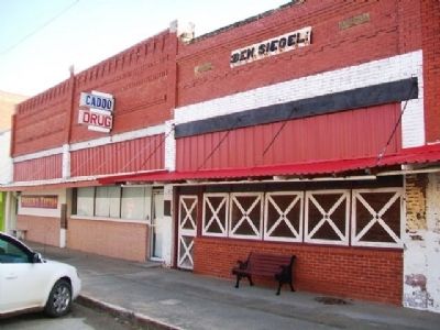
Ben Siegel Building and Marker
| On Buffalo Street (State Highway 22) west of Main Street, on the right when traveling east. |
| On Buffalo Street (State Highway 22) west of Main Street, on the right when traveling east. |
| On Buffalo Street (State Highway 22) at Main Street, on the right when traveling east on Buffalo Street. |
| On Buffalo Street (State Highway 22) west of Main Street, on the right when traveling east. |
| On Quanah Road west of Chickasha Road, on the left when traveling west. |
| On Seventh Street, on the left when traveling west. |
| Near Gott Road, 0.7 miles south of West Southgate Road, on the right when traveling south. |
| On Main Street (U.S. 77) at 7th Street, on the left when traveling north on Main Street. |
| On Main Street (U.S. 77) south of 7th Street, on the right when traveling north. |
| On Main Street (U.S. 77) at 8th Street, on the left when traveling north on Main Street. |
| On Main Street (U.S. 77) at 7th Street, on the left when traveling north on Main Street. |
| On Main Street (U.S. 77) north of 7th Street, on the left when traveling north. |
| On Broadway near 3rd Street, on the right when traveling south. |
| On Broadway (Business U.S. 69) at North Avenue, on the right when traveling north on Broadway. |
| On Gentry Avenue (U.S. 266) at 2nd Street, on the right when traveling west on Gentry Avenue. |
| On Paul Carr Drive, 0.2 miles south of Gentry Avenue (U.S. 266), on the left when traveling south. |
| On East Ash Avenue just east of Lee Street, on the left when traveling east. |
| On Chickasaw Avenue/194th Street West (State Highway 72) 1 mile north of Haskell Boulevard (U.S. 64), on the right when traveling north. |
| On Honor Heights Drive, on the left when traveling north. |
| On Honor Heights Drive, on the left when traveling north. |
| On Elgin Street west of 2nd Street, on the right when traveling west. |
| On Honor Heights Drive, on the left when traveling north. |
| On 32nd Street (U.S. 54/69) 0.2 miles north of Hancock Street, on the right when traveling north. |
| On Honor Heights Drive, on the left when traveling north. |
| On Honor Heights Drive, on the left when traveling north. |
| On Honor Heights Drive, on the left when traveling north. |
| On Honor Heights Drive, on the left when traveling north. |
| On Highway 66 east of Division Street, on the left when traveling east. |
| On State Highway 66 east of Division Street, on the left when traveling east. |
| On Robinson Avenue south of NW 6th Street, on the left when traveling north. |
| On NE 21st Street west of Lincoln Boulevard, on the right when traveling west. |
| On Robinson Avenue at NW 7th Street, on the right when traveling north on Robinson Avenue. |
| On South Agnew Avenue at Southwest 13th Street, on the left when traveling north on South Agnew Avenue. |
| On NE 21st Street near Lincoln Boulevard, on the right when traveling west. |
| On Walker Avenue at NW 10th Street, on the left when traveling north on Walker Avenue. |
| On Main Street west of Katy Avenue, on the left when traveling west. |
| On Kihekah Avenue south of 6th Street, on the right when traveling south. |
| On Kihekah Avenue at 7th Street, on the left when traveling north on Kihekah Avenue. |
| On 1st Street (U.S. 60) at Locust Avenue, on the left when traveling south on 1st Street. |
| On Main Street (Route 66) (U.S. 69) north of 3rd Avenue (State Highway 10), on the right when traveling north. |
| On Main Street (Route 66) (U.S. 69) south of Central Avenue, on the left when traveling south. |
| On U.S. 283, 0.2 miles north of Ranch to Market Road E 1070, on the right when traveling south. |
| On Cooweescoowee Avenue at Maple Street, on the right when traveling west on Cooweescoowee Avenue. |
| On Elm Street (U.S. 169) at Cooweescoowee Avenue, on the right when traveling north on Elm Street. |
| On Main Street (Oklahoma Route 20) west of 9th Street, on the left when traveling west. |
| On 21st Street, on the right when traveling west. |
| On Cincinnati Avenue at 9th Street, on the right when traveling south on Cincinnati Avenue. |
| On Boston Avenue at 7th Street, on the left when traveling south on Boston Avenue. |
| On Harvard Avenue at 17th Street, on the left when traveling south on Harvard Avenue. |
| On Cherokee Street (State Highway 51) at Main Street, on the right when traveling west on Cherokee Street. |
| On Cherokee Street (State Highway 51), on the left when traveling east. |