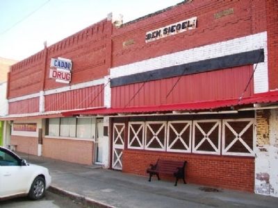
Ben Siegel at age 14 came to America from Lithuania. He established a business in Caddo, Indian Territory in 1895. One of Bryan County's first merchants, he was an important part of the early trade area. — — Map (db m73423) HM
In 1955 the Craighead family purchased this store which for over four decades has served and intrigued children as well as adults:
Partial records show previous owners as:
E. F. Nichols - original site - 1905
Boone Styron Dry Goods - . . . — — Map (db m73424) HM
John S. Hancock and his young son Clement Allen Hancock followed the MKT Railroad to Caddo in 1872. They established a business at this location and became two of Caddo's founding businessmen and community leaders. — — Map (db m73410) HM
Built by Woodmen of the World, this site has served businesses as well as Caddo schools as a classroom. One of its most famous occupants was John L. "Judge" Boland, opening a law office in 1910. He served as city attorney and a civic leader . . . — — Map (db m73426) HM
This building was originally constructed in 1870 to serve as the commissary storehouse. It is unique among all the historic buildings, having started as a horizontal, log structure resting on a stone foundation over 200 feet in length. By 1872, the . . . — — Map (db m60884) HM
In 1895 a concrete walk was installed by the City of Bristow across Main Street at 7th Street. The sloping sides allow the wagons to cross the walk. When Main Street was paved in 1915 the walk was removed. Both the installation and removal were . . . — — Map (db m41941) HM
A section of the famed Chisholm Trail (1867-1885), which was used to drive cattle from Texas to the rail heads in Kansas after the Civil War, crosses a portion of Vance AFB near the entrance to the Armed Forces Reserve Center. The trail was named . . . — — Map (db m89793) HM
This Roman Classic structure with a corner recessed entry and simple columns was built in 1899. The building was originally known as the Dilday building and is constructed with native limestone secured a few miles east of Newkirk. John Pierce . . . — — Map (db m60456) HM
Dick Sherbon of Ponca City received the bid to erect this building for the Kay County Abstract Company in 1926. The bids for the building ranged from $4,400 to $5,700.
This red brick structure was limited to one story because of the . . . — — Map (db m60479) HM
This statue, "Land of Hope," depicts the courageous pioneers who staked their land claim in the "Land Run of the Cherokee Outlet" in 1893. This was created by sculptor, Bernadette Hess Carman, a native daughter, who generously donated her time . . . — — Map (db m60449) HM
Newkirk was originally platted as the townsite of Lamoreux by the United States Land Office in 1893 as the county seat of "K" county. It was named after Silas W. Lamoreaux who was the head of the General Land Office in Washington, D.C., at the . . . — — Map (db m60455) HM
William S. Cline had this building constructed in 1925. This was the same year that the Kay County Courthouse and the Masonic Temple were constructed in Newkirk. The Cline Building is illustrative of the influence of the Art Deco style. . . . — — Map (db m60478) HM
Paved in 1925 with bricks
manufactured at the
Davenport Brick & Tile Corp.
Financed with Paving District Bonds
Davenport Brick Plant in Operation
1911 - 1929 — — Map (db m41779) HM
• Was a 2290 mile transcontinental "National Trail" from Winnipeg, Canada to New Orleans, Louisiana;
• Roadway through town ran from North Broadway to Gentry Avenue, then on SW 2nd Street and back to South Broadway;
• Route formed what . . . — — Map (db m73153) HM
Established - 1890
Sanctuary Built - 1917
Has been placed on the
National Register
of Historic Places
by the United States
Department of the Interior
November 13, 1984 — — Map (db m73156) HM
Originally built on this site by the United States Army, Colonel Matthew Arbuckle and the United States Infantry. Rebuilt by WPA and the State of Oklahoma in 1935-36. The exact duplicate of the original. — — Map (db m136565) HM
This open air theatre is dedicated as a living memorial to our comrades of World War I and World War II who gave their lives in the service of their beloved country.
It looks across to the Cookson Hills, the site of Camp Gruber, where the . . . — — Map (db m108931) HM WM
The American Society of
Landscape Architects
1899-1999
This site is recognized as
a National Landmark for Outstanding
Landscape Architecture — — Map (db m108934) HM
The Midland Valley Railroad Company was incorporated in 1903 and headquartered in Muskogee. This passenger station was built in 1917 and during the 1920's as many as eight trains carrying 9,000 passengers per day traveled from Tulsa to this point. . . . — — Map (db m108907) HM
Muskogee Oil Refining Company, organized in March 1905, built a finishing plant near this site in November, 1904. It soon was producing lamp kerosene, lubricating oil and industrial fuel - the beginning of oil refining in Oklahoma, a leading . . . — — Map (db m73123) HM
Consolidated U. S. Indian office for Five Civilized Tribes. Cornerstone of old stone building here laid Aug. 18, 1875, in ceremony led by Agent G. W. Ingalls, with address by Wm. P. Ross, Chief, Cherokee Nation; first Masonic cornerstone laying in . . . — — Map (db m108935) HM
Begun in 1875, this Agency was the first building erected by the U.S. government to house the superintendencey [sic] of the Five Civilized Tribes. Used briefly, the building was leased in 1875 to the Baptist Mission Society as a school for the . . . — — Map (db m108939) HM
(East Elevation)
Erected in commemoration of
members of the Five Civilized Tribes,
whose record of enlistment, conduct in camp,
and fortitude and valor on the battlefield,
added lustre to the triumphant victory of our country
in . . . — — Map (db m108942) HM WM
This outdoor toilet, often referred to as outhouse or privy, was originally behind the Bright Day Lodge on Main Street. In earlier days this was an essential structure for every business and home. On Halloween night in Arcadia these buildings were . . . — — Map (db m83067) HM
It is with Love, Admiration,
Affection, and in their
Loving Memory We the
Children of
Frank and Katie Vrana
Give this
Historic Round Barn
to the
Arcadia Historical and
Preservation Society, Inc.
April 26, 1998
Mary Francis . . . — — Map (db m83047) HM
It is with Love and Appreciation
we the Society Dedicate this
Historical Round Barn to
Luke and Anna Robison
For without Their Tireless Efforts
and Complete Devotion, this
Historical Landmark could not
have been saved
Thank You . . . — — Map (db m83046) HM
[Excerpts from marker]
This 24,000 square foot Museum exhibit tells the story of the April 19, 1995, bombing of the Alfred P. Murrah Federal Building. You hear the explosion, see the devastation immediately following and learn from family . . . — — Map (db m60376) HM
The Stockyards City Business Improvement District serves as a home to the world's largest stocker-feeder cattle market, the state's oldest restaurant, library, pharmacy and western wear establishment. The bank was chartered in 1925 and has . . . — — Map (db m144284) HM
This statue was fashioned by
Constance Whitney Warren
Sculptress of Paris, France and New York,
and was presented to
The State of Oklahoma
by this distinguished American Artist
through the solicitation of
Justice Albert C. . . . — — Map (db m59952) HM
"New Territory" is local artist, Cha' Tullis' depiction of years past as a party of Indians top a hill to find a valley with fresh running water; a perfect place to camp and rest. Made of 1/4" sheet steel, pipe and sucker rods, the sculptured . . . — — Map (db m81147) HM
Vernon Whiting, builder of the "Historical Whiting Apartments" in the 1920's, was born in 1870 in Ogdensburg, New York. His family later moved to Seward, Nebraska. Vernon graduated high school there in Seward, then took a business course at . . . — — Map (db m81152) HM
A replica of a sign originally constructed in the 1900's that spanned Central and C Street adjacent to the railroad station. For many years this sign welcomed visitors to downtown Miami. The original sign was removed during the 1930's. Today's . . . — — Map (db m119947) HM
The Clock hanging above this plaque was manufactured by the O. B. McClintock Co. of Minneapolis. It was brought to Miami by the Miami Trust and Savings Bank in 1917. For 59 consecutive years, it hung from the corner of the Professional Building at . . . — — Map (db m81104) HM
Born in the Going Snake District, Cherokee Nation, Clem was the only son of Sallie Vann and Robert Rogers, Jr. He was educated in the Cherokee Nation.
He married Mary America Schrimsher, also part Cherokee, in 1858. He later served in the . . . — — Map (db m111454) HM
Believed to be the oldest
commercial building in
downtown Oologah
circa 1890
Donated by
Claude & Doris Worden Armbrister
————————————
Cooweescoowee Ave. & Maple . . . — — Map (db m111458) HM
The original model of the miniature house was built in 1928 by Zennie Taylor (1890-1969) as a school project for the Tulsa State Fair. By 1930 he had constructed a permanent replica which was dedicated at a special "WILL ROGERS DAY" . . . — — Map (db m111435) HM
This building is dedicated to
those who served our country
by the community of Collinsville
Lest We Forget
Dedicated to
the memory of
our departed comrades — — Map (db m111484) WM
The International Petroleum Exposition was founded at Tulsa, Oklahoma, in 1923 providing a display to the world of the latest in equipment, operational ideas and practices used in the petroleum and related industries.
When the first exposition . . . — — Map (db m111504) HM
The Elliott Building at 9th and Cincinnati housed the original site of the Oklahoma College of Osteopathic Medicine and Surgery from July 1974 to December 1977. Tulsa Junior College generously provided room for President John W. Barson, Ed.D., . . . — — Map (db m67907) HM
First church in Tulsa
First meetings - 1883
Chartered as a congregation - 1885
The Centennial Marker
Given 1985 by the
Mr. and Mrs. Class
Organized in 1929 — — Map (db m68019) HM
With the faith and courage of
their forefathers who made
possible the freedom of these
United States
The Boy Scouts of America
dedicated this replica of the
Statue of Liberty as a pledge
of everlasting fidelity and
loyalty
40th . . . — — Map (db m111406) HM
The Colonial Garden is the third garden in the series of five historic theme gardens.
Colonists claiming the Virginia wilderness brought with them the formal, Dutch-English gardening style prevalent in England during the reign of William and . . . — — Map (db m68034) HM
In 1906 the City leased the lots & built this brick structure for $1,011.68 to house the Fire Department, City Offices, & City Council Room — — Map (db m68084) HM