First Harbor
From its beginnings as a shallow creek-mouth anchorage through its heyday as seventh busiest port in the world, Buffalo Harbor has undergone a series of major changes.
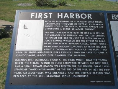
The first harbor was built in 1820 and 1821 by the . . . — — Map (db m85195) HM
Hurricane-force winds screamed across the Great Lakes on Nov. 9 and 10, 1913, in a storm that claimed more than 250 lives and sank a dozen ships- including Light Vessel 82, one of a series of Buffalo lightships. L.V. 82 was on station 13 miles . . . — — Map (db m85163) HM
Early History Converting the mouth of the Buffalo River into a safe and easily navigable harbor was a work of great magnitude and cost. The mouth of the Buffalo River frequently became clogged by sands moving north along the beach towards the . . . — — Map (db m85329) HM
The frequent loss of elevators to fire and explosion prompted a search for safer building materials and construction methods. Experiments with fireproof materials centered on steel, tile, and concrete. The Great Northern Elevator (1897) and . . . — — Map (db m85657) HM
Times Beach was, at one time, an actual sand beach. The beach formed as a result of the improvements to Buffalo's inner harbor. Prior to the harbor improvements the mouth of the Buffalo River was frequently clogged with sands that moved north along . . . — — Map (db m85280) HM
Welcome to one of the most historic places in Buffalo - the place where villagers built a harbor that, in turn, built a city. The parkland, promenade and restored lighthouse here were once key elements of the old Port of Buffalo. Early in the 19th . . . — — Map (db m84923) HM
The worst disaster in Buffalo Harbor history took place in the Buffalo River at this point on the night of Oct. 29, 1951, when the outbound freighter Penobscot and the gasoline barge Morania collided, sparking an explosion and fire that took 11 . . . — — Map (db m85083) HM
Image Source: Historic American Engineering Record. Jet Lowe, photographer, 1985. The American Elevator was the first reinforced concrete grain elevator built on Buffalo's waterfront. It was designed and built by the James Stewart Company for the . . . — — Map (db m85960) HM
Image Source: Historic American Engineering Record. Jet Lowe, photographer, 1990. The Superior Elevator, as it was originally known, was built in 1915 by the Monarch Engineering Company for the Husted Milling Company. A.E. Baxter was the . . . — — Map (db m85961) HM
The Coast Guard Base in Buffalo is both a lifeboat station and a regional headquarters covering American Coastal waters from eastern Ohio to the Thousand Islands area of the St. Lawrence River. Units here include station Buffalo, Group Buffalo . . . — — Map (db m84984) HM
Image Source: Historic American Engineering Record. Jet Lowe, photographer, 1994. The Concrete Central Elevator is located between the Buffalo River and the track of the former New York Central Railroad. It is the furthest upstream of any . . . — — Map (db m85957) HM
Wheat was one of the first agricultural products planted by European colonists in the New World. In colonial times, it was not only a staple of life, but also became an item of national and foreign trade. The western movement of population . . . — — Map (db m85538) HM
Image Source: Historic American Engineering Record. Jet Lowe, photographer, 1994. The oringinal Electric Elevator, built in 1897, was one of the first elevators to use electricity as a power source. The original construction consisted of nineteen . . . — — Map (db m85963) HM
During the first half of the twentieth century, over 30 concrete grain elevators lined Buffalo's inner and outer harbors, representing the culmination of over 60 years of grain elevator design. Beginning in 1842 with entrepreneur Joseph Dart and . . . — — Map (db m85435) WM
In the years following the opening of the Erie Canal, Buffalo's harbor was becoming increasingly clogged with ships awaiting their turns to unload their cargos. A full team of dock workers could unload at most 2,000 bushels a day, and even then, . . . — — Map (db m85530) HM
Fortuitous geography, local engineering ingenuity, and American business acumen were to combine to assure Buffalo a pivotal role in the forwarding of grain to national and international markets. After the opening of the Erie Canal in 1825, . . . — — Map (db m85392) HM
Image Source: Historic American Engineering Record. Jet Lowe, photographer, 1990. The Lake and Rail Elevator was developed by International Milling Inc., which established a new milling operation in Buffalo in 1926. Within four years of the . . . — — Map (db m85881) HM
Established in 1789, the U.S. Lighthouse Service maintained lighthouses and a district headquarters in Buffalo until it was absorbed by the Coast Guard in 1939.
Tenth District, long under the command of District Lighthouse Superintendent Roscoe . . . — — Map (db m84982) HM
Image Source: Historic American Engineering Record. Jet Lowe, photographer, 1990. The Marine 'A' Elevator, constructed in 1925, is actually the third Marine elevator built by the Abell family of Buffalo. The original wooden Marine elevator, built . . . — — Map (db m85904) HM
Image Source: Historic American Engineering Record. Jet Lowe, photographer, 1994. The perot Company, a business dating back to the late 1600s in Philadelphia, relocated its operations to Buffalo in 1907. The company commissioned the construction . . . — — Map (db m85907) HM
Image Source: Historic American Engineering Record. Jet Lowe, photographer, 1990. The Saskatchewan Pool Elevator, was built in 1925 by the Monarch Engineering Company for the Canadian Farmers Cooperative. Its designer was C.D. Howe, a noted civil . . . — — Map (db m85748) HM
Image Source: Historic American Engineering Record. Jet Lowe, photographer, 1994. This 1,000,000 bushel elevator was completed in 1911 to supply Spencer Kellogg's linseed oil mill, the world's largest at the time. Unlike most of the elevators on . . . — — Map (db m85849) HM
Image Source: Historic American Engineering Record. Jet Lowe, photographer, 1985. The Standard Elevator stands next to the Buffalo River, immediately upstream of the Ohio Street Bridge. It was built in two phases of development. It was designed . . . — — Map (db m85795) HM
Image Source: Historic American Engineering Record. Jet Lowe, photographer, 1994. The Wheeler Elevator, designed by H.R. Wait, was built in 1909 by the Monarch Engineering Company. The elevator had several unique features. It was the first . . . — — Map (db m85855) HM
1655: Seneca Indians win control of Niagara Region from Erie tribes. 1678-79: French explorer Rene-Robert Cavelier, Sieur de la Salle, claims the region for France. He builds a sailing ship, Griffon, on the bank of the Niagara River and . . . — — Map (db m80361) HM
Residents of the "Towpath" fished and hunted the Erie Canal from a cluster of weather beaten homes, hunting and fishing clubs, taverns and stores leaning at strange angles, perched on wobbly stilts. Fishing was a popular pastime, as well as an . . . — — Map (db m80459) HM
[left panel] Niagara River Corridor, 43°E 07'N, 79°E 04W The Niagara River Corridor is considered an Important Bird Area (IBA). IBAs are areas that are critical to bird populations, including nesting locations, key migration stop-overs and winter . . . — — Map (db m98191) HM
The history of steel production in Lackawanna has its roots in the Lackawanna Valley of northeast Pennsylvania. It was there that the Lackawanna Iron and Steel Company was formed in 1891, the result of a previous consolidation of various iron and . . . — — Map (db m86106) HM
Buffalo's Breakwater System The desirability of an outer harbor for Buffalo was recognized as early as 1835. Built between 1838 and 1867 along what is now Fuhrmann Blvd., the sea wall provided protection of the inner harbor. By 1867 Buffalo . . . — — Map (db m86359) HM
The first full-sized sailing ship to sail Lake Erie and the uppper Great Lakes was Le Griffon, built by French Explorer Robert de La Salle in 1679. Previous sailing ships were confined to Lake Ontario due to the natural barrier of Niagara . . . — — Map (db m86021) HM
The maritime industry of the Great Lakes expanded greatly after completion of the Erie Canal in 1825. The canal allowed a growing U.S. population into the Midwest, which turned the Great Lakes into busy nautical highways for moving wheat, corn, . . . — — Map (db m86025) HM
The Great Lakes and many resources of the Great Lakes basin have played a major role in the history and development of the United States and Canada. For the early European explorers and settlers, the lakes and their tributaries were the avenues for . . . — — Map (db m86006) HM
The Lehigh Portland Cement Company was originally known as the Great Lakes Portland Cement Company. The plant was constructed in 1925 on a 23 acre site adjacent to Lake Erie and the Union Ship Canal. The plant employed over 250 people, and had a . . . — — Map (db m86100) HM
The Union Ship Canal came about as a collective effort of railroad, shipping, banking, and iron smelting business interests. The founders of the Buffalo and Susquehanna Iron Company (the predecessor to Hanna Furnace) controlled rail lines to Buffalo . . . — — Map (db m86097) HM
Panel 1 [upper]:
“RUST BUCKET”
[Fanciful rendering of a World War II Liberty Ship]
Our convoy ships were referred to as the “Rust Bucket Brigade” because they were never in port long enough to get a . . . — — Map (db m77323) WM
You are looking across a restoration of the Commercial Slip, originally the western terminus of the Erie Canal. In its heyday, this area was one of the world's great transportation centers, teeming with canal, lake, and rail traffic, a busy port . . . — — Map (db m84559) HM
In 1842, the world's first steam powered elevator to transfer and store grain opened on this site. Buffalo merchant, Joseph Dart, and machinist, Robert Dunbar, built the elevator following precedents set by Oliver Evans. Its basic principles are . . . — — Map (db m151380) HM
Commercial Slip connected the Buffalo River to the Erie Canal mainline, 100 yards northeast of this site. It marked the original terminus of the Erie Canal, but was soon joined by many other artificial waterways around Buffalo Harbor. As commerce . . . — — Map (db m84868) HM
Already a major transportation center, Buffalo was evolving into a center of industry and and manufacturing. At the height of the canal era, in the mid-1800s, countless manufacturing enterprises took advantage of the huge volume of raw materials . . . — — Map (db m231814) HM
When the Erie Canal was completed here in October 1825, Buffalo was transformed from a small lakefront hamlet to a thriving muscular metropolis. Buffalo was the port where grain, lumber, and other products from the interior of the American continent . . . — — Map (db m84859) HM
Pre-1800 The Ongiara Confluence of Little Buffalo Creek and the Buffalo River with Lake Erie in the background, 1815. The region's original inhabitants were the Ongiara, a peaceful Iroquois tribe, from whom the name Niagara is derived. Long . . . — — Map (db m84777) HM
Buffalo’s Birthplace: Where the Erie Canal Joins the Commercial Slip Look closely at this wonderful picture of Buffalo’s Waterfront in its heyday for evidence of life in those early days before the railroads took over the waterfront. Note . . . — — Map (db m140650) HM
Canal and Harbor Transforming Buffalo The Erie Canal formally opened on Oct. 26, 1825, connecting the heartlands of the continent to the rest of the world. As the engineering marvel of its time, the canal helped transform Buffalo into the . . . — — Map (db m140745) HM
The "Red Warehouse” was a pioneering
harbor structure among the earliest major
commercial buildings in Buffalo. Located along
the Buffalo Creek, it was a commercial gamble
by George Coit and Charles Townsend, and a
demonstration of Buffalo's . . . — — Map (db m201084) HM
The Erie Canal was America's most successful and influential public works project. Completed in 1825, the 363-mile-long waterway established the first all-water route for navigation between the Atlantic Ocean and the upper Great Lakes, opened the . . . — — Map (db m84822) HM
There was fierce competition between Buffalo and Black Rock for the Canal's western terminus. Albany, the link to New York City, emerged as the perfect choice for the eastern end of the Canal. The western end was a far less obvious proposition. . . . — — Map (db m84496) HM
Historic Lake Erie Named for the Indian Nation of the Eries who dwelt on these shores before 1634 when they were conquered by the Iroquoian Confederacy. 1641 – Earliest mention of the lake in writing of French missionaries. 1669 – First white . . . — — Map (db m241046) HM
[Rendering of Poland’s “White Eagle” Coat of Arms and Polish soldiers in action during WWII] This memorial is dedicated to the members of the Polish Armed Forces who gallantly participated in active combat on land, high seas and in the . . . — — Map (db m76072) HM WM
With the close of World War II, the United States Navy scrapped or sold almost its entire PT Boat fleet. During the next twenty years, differing fast patrol and torpedo/missile armed boat designs were experimented with. However, no new class of . . . — — Map (db m75883) HM WM
In 1926, the Hamburg drain, a major sewer line draining South Buffalo was built; as a result, the Commercial Slip, the Erie Canal's original western terminus, was filled in. Today the Commercial Slip has been restored: the redesign incorporates . . . — — Map (db m84477) HM
The background map is based on an early 20th century map surveying the canal system of New York, expanded to show the network of shipping routes that grew in the wake of the Erie Canal. There is no clearer picture of America's growing economy: the . . . — — Map (db m84908) HM
The Erie Canal This site marks the west end of the canal opened in 1825. It carried products and people between Lake Erie and the Hudson River. Two Waterfronts The convergence of lake and canal made possible the . . . — — Map (db m84473) HM
Skeptics dubbed the project "Clinton's Folly" and "Clinton's Ditch" when construction of the Erie Canal began near Rome on July 4, 1817, deriding both the project and its principal promoter. Things were very different by October 24, 1825 when . . . — — Map (db m84848) HM
The Immigrant Steps. Building Buffalo. Great waves of 19th Century immigration flowed through East Coast ports to Buffalo. Thousands traveled by water vessels, while others took wagons from New England and Pennsylvania to ships headed west. Many . . . — — Map (db m140646) HM
Lifting Buffalo to World Renown. In 1924 Buffalo led the world in handling grain. 300,000,000 bushels passed throught Buffalo harbor, unloaded, lifted, stored, and reloaded by the grain elevators that still stand tall along the banks of the . . . — — Map (db m84694) HM
The Ruins at Canalside. Drinking in 19th Century Buffalo. The authentic remnant of Canal District commerce known now as the Ruins at Canalside, was home to a prominent Commercial Slip building that saw multiple uses in the mid-19th Century as the . . . — — Map (db m140645) HM
Scuttled by her crew due to damage inflicted by enemy aircraft. All members were captured by the Japanese and imprisoned until war's end. Crewmen that died in P.O.W. camp: Doyle, Charles - MOMM1; Linder, Charles - MOMM2; Guico, Justiano - MATT1; . . . — — Map (db m88231) WM
Seventh U.S. Warship named for the Capital City of Massachusetts. Commissioned 30 January 1982. Decommissioned 19 November 1999. Built by General Dynamics Electric Boat Division, Groton, Connecticut. Commanding Officers 01/1982 - 08/1982 CDR . . . — — Map (db m84802) HM
Waterfront Sites From the LaSalle Park Gateway From the miltary garrison in Fort Erie to the wind turbines visible to the south, this vantagepoint depicts the endeavors of over 250 years of economic history. LaSalle Park. Named for the . . . — — Map (db m93008) HM
It was at this spot on the morning of October 26, 1825, that Governor DeWitt Clinton officially opened the waterway that transformed America. More than eight years had passed since he broke ground on the canal, and after 363 miles, the engineering . . . — — Map (db m84500)
William Wells Brown, an escaped slave from Kentucky, earned his living as a cook on lake freighters in the early days of the Erie Canal. In 1836, he moved his family to Buffalo, and soon became involved with the city's African-American community. . . . — — Map (db m84558) HM
The Niagara River between Lakes Ontario and Erie was the natural route to the interior of the continent. Following the arrival of French explorers in 1678, missionaries, traders, troops and settlers traveled by its waters. At the outlet of the . . . — — Map (db m57072) HM
Strawberry Island formed near the end of the Wisconsin Ice Age about 12,000 years ago. When meltwaters broke through gracial till and created the present course of the Niagara River, gravel and sand carried downstream by river currents settled out . . . — — Map (db m101061) HM
Strawberry Island is located in the Upper Niagara River southeast of Grand Island. This five-acre island supports a diverse collection of aquatic plants and animals. It also protects 400 acres of emergent wetlands and shallows from the mighty river . . . — — Map (db m101085) HM
Ships and Sunsets. If you could have stood on this spot for 300 years, you would have seen a parade of vessels carrying Native Americans, explorers, trappers, fishermen, traders, shippers, and sailors traveling and transporting people and goods on . . . — — Map (db m82603) HM
Prior to the construction of land based lighthouses, lightships were used to provide navigational guidance along shipping lanes of the Great Lakes. Lightship LV82 was built in July 1912 with a steel hull and whaleback forecastle
deck. It measured . . . — — Map (db m133028) HM
Welcome to Tonawanda Gateway Harbor - where the Niagara River meets the Erie Canal. Prior to the 1800's this area was a wilderness frequently traversed by Seneca Indians from the Iroquois Confederacy. The first known white settlers were Henry . . . — — Map (db m87802) HM
You are standing on the bed of the Erie Canal, a 363 mile long, 40 ft. wide, 7 ft. deep "ditich" built from 1817 to 1825 that connected Lake Erie waters with the Hudson River and ultimately the Atlantic Ocean. It unleashed a flood of products, . . . — — Map (db m98540) HM
To avoid the strong current of the mighty Niagara River, the Erie Canal was built adjacent to the river from here to Buffalo in 1825. — — Map (db m78352) HM
In 1884, the Tonawanda Gas Light Company was incorporated to supply gas to both Tonawanda and North Tonawanda for street and house lighting. The "gas works" was located on property once owned by Mary Long. Between the Canandaigua and Erie . . . — — Map (db m166212) HM
During the 1800s, many Americans and newly arrived immigrants were eager to move west, but this undertaking proved difficult because of the Appalachian Mountains. A natural barrier running from Alabama through Pennsylvania, New York and on into . . . — — Map (db m77385) HM
You are standing at the site of Tonawanda's Grand Island Ferry Landing. For nearly a century access to Grand Island was provided by ferry service. The Grand Island Ferry consisted of a tug and scow carrying horses, wagons, automobiles, buses, . . . — — Map (db m98519) HM
Three Centuries of Commerce The first great ship to pass by this spot was the Griffin built by Robert de La Salle in 1679 near Cayuga Island just around the bend behind Grand Island. She sailed up the Niagara River past this point . . . — — Map (db m98517) HM
Thanks to the Erie Canal, the Niagara River, a naturally commodious harbor and a growing railroad center, the Tonawandas became a thriving lumber port during the last half of the nineteenth century. Lumber from Minnesota, Wisconsin, Michigan and . . . — — Map (db m166243) HM
An Overview
In the spring of 1823, work on the Erie Canal at this end of the state began with the building of a dam. Its purpose was to raise the water level of Tonawanda Creek 4 to 4 1/2 feet so that its ten-mile stretch between Pendleton . . . — — Map (db m77499) HM
In December of 1828, Benjamin and Mary Hershe Long arrived here from Lancaster County, Pennsylvania, in a covered wagon drawn by oxen. With them were their five daughters, ranging in age from 6 months to 16 years.
Their home, built the following . . . — — Map (db m77330) HM
Life on the Canal Boat The average canal boat owner was a family man, and often his family traveled the canal with him. Living quarters were the cabin under the stern deck and in the small space a woman did her washing and ironing in addition to . . . — — Map (db m87777) HM
Rise of the Railroad
On August 26, 1836, the first steam locomotive in Western New York made its maiden run between Black Rock and Tonawanda at a speed of 15 - 20 miles an hour. By the 5th of November that same year, regular trips were made . . . — — Map (db m77302) HM
The westernmost leg of the Erie Canal completed in 1825 followed a route paralleling the Niagara River between Tonawanda and Buffalo. From where you are standing, the Canal travelled some ten miles through the mostly unsettled Township of Tonawanda . . . — — Map (db m98556) HM
Timothy Taft oversaw construction of the first dam at this site in 1828. The creek flowed north, then turned to the south to drop
over a natural rock ledge. Taft constructed two earth berms that came together at an angle to divert the main flow of . . . — — Map (db m195938) HM
The aerial photograph of Port Henry taken about 1925 leaves no question as to the nature of this place: a busy port shipping the products of its furnaces by water and by rail. Two new furnaces, begun in 1922, represented the latest technology. An . . . — — Map (db m109054) HM
The aerial photograph of Port Henry taken about 1925 leaves no question as to the nature of this place: a busy port shipping the products of its furnaces by water and by rail. Two new furnaces, begun in 1922, represented the latest technology. An . . . — — Map (db m109055) HM
Iron processing changed the shoreline of Port Henry. When the New York and Canada Railroad was built in 1874, the tracks hugged the lake. That same year, a modern blast furnace was built at Cedar Point, just beyond the train station. Eight blast . . . — — Map (db m109053) HM
The first of Port Henry's many iron furnaces was erected just west of here in 1822. Throughout the 19th century new furnaces, crushers, concentrating plants, and casting houses were added to increase production.
The key to the success of Port . . . — — Map (db m108995) HM
The first Lake Champlain Bridge between Crown Point, New York, and Chimney Point, Vermont, opened in 1929. Primarily serving tourists when it opened, it ultimately became an important connection for residents and businesses across the region. A . . . — — Map (db m108975) HM
Charles M. Spofford, an engineer of the Boston firm Fay, Spofford & Thorndike, designed the 1929 Lake Champlain Bridge. It was the first American highway bridge to employ a continuous truss design to create a curving transition between the deck . . . — — Map (db m109074) HM
On November 7, 2011, after 25 months without a bridge, traffic once again began to flow over Lake Champlain at the Crown Point-Chimney Point crossing. The opening of the new Lake Champlain Bridge restored the vital transportation link between New . . . — — Map (db m108976) HM
ALL IDEAS WELCOME
Desperation led Henderson and others to devise grand schemes to connect the iron making community to eastern markets over various routes and using several different modes of transport.
RAILROADS
Henderson's and . . . — — Map (db m148152) HM
This dam gets its name from its position as the third dam down from the outlet of
Lake George. It was the last location to be exploited along the LaChute. This site
required a broad dam high enough to make its power-generating "head” . . . — — Map (db m158318) HM
The La Chute River supplied more than power for the mills. It also connected to Lake Champlain and the wider world. People and goods traveled much more easily by water than by land, so the corridor formed by Lake Champlain, Lake George and the . . . — — Map (db m125180) HM
The LaChute is a river with both a short course and a short history. It cut its way through Ticonderoga only 12,000 years ago, when the waters of the newly-formed Lake George first spilled over a ridge between Mount Defiance'and Cook's Mountain. . . . — — Map (db m157904) HM
From the time of the first land survey of the lower falls in 1822, a bridge has crossed LaChute River here, where Spencer Creek once rejoined the main stream. Eventually, the bridge took its name from the planing mill run by B.F. Frazier on the . . . — — Map (db m158199) HM
The tides of history have swept repeatedly through this valley, following the river
that drains Lake George into Lake Champlain, 220 feet below. When forests covered the land, people traveled by water, so this short link between the 33 miles of . . . — — Map (db m158367) HM
Lake Champlain, 125-miles long, flows northward into the Richelieu River which, in turn, flows into the St. Lawrence River. From Ticonderoga, the lake stretches another 25 miles south to its end near present-day Whitehall, New York. During the . . . — — Map (db m126174) HM
Water Power: From Waterwheel to Industrial Turbine
For centuries, people have been harnessing energy from moving water. In the 1800s and early 1900s, industries flourished here thanks to the falls of La Chute River, which provided an . . . — — Map (db m156435) HM
1226 entries matched your criteria. Entries 201 through 300 are listed above. ⊲ Previous 100 — Next 100 ⊳