After filtering for Colorado, 55 entries match your criteria.
Natural Features Topic
By William Fischer, Jr., October 15, 2020
A Landmark for People Marker
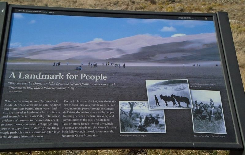
| 1 ► Colorado, Alamosa County, Great Sand Dunes National Park and Preserve — A Landmark for People — Great Sand Dunes National Park and Preserve — National Park Service, U.S. Department of the Interior — |
| Near Highway 150. | |||
| 2 ► Colorado, Alamosa County, Mosca — "Totally Unique and Unexpected" — Great Sand Dunes National Park and Preserve — National Park Service, U.S. Department of the Interior — |
| Near Highway 150 near Pinyon Circle. | |||
| 3 ► Colorado, Alamosa County, Mosca — Dimensions — Great Sand Dunes National Monument — |
| On State Highway 150. | |||
| 4 ► Colorado, Alamosa County, Mosca — Sangre de Cristo Ecosystem — Great Sand Dunes National Park and Preserve — |
| Near Highway 150. | |||
| 5 ► Colorado, Alamosa County, Mosca — Stepping into Wilderness — Great Sand Dunes National Park and Preserve — National Park Service, U.S. Department of the Interior — |
| Near Highway 150. | |||
| 6 ► Colorado, Alamosa County, Mosca — The Mountain Barrier — |
| Near Highway 150. | |||
| 7 ► Colorado, Alamosa County, Mosca — Understanding the Great Sand Dunes System: the Sand Sheet — |
| On Lane 6N, 1.2 miles west of State Highway 150, on the left when traveling west. | |||
| 8 ► Colorado, Archuleta County, Pagosa Springs — Pagosa Springs — |
| Near Hot Springs Blvd. | |||
| 9 ► Colorado, Delta County, Delta — Ute Council Tree — |
| On G96 Lane at 1550 Road, on the left when traveling west on G96 Lane. | |||
| 10 ► Colorado, Denver County, Denver, Central Business District — 6w — Rails and Mountains — Wall Street of the Rockies — Seventeenth Street Denver, Colorado — |
| On 17th Street at Arapahoe Street, on the right when traveling south on 17th Street. | |||
| 11 ► Colorado, Denver County, Denver, Central Business District — 18e — Top of the World — Wall Street of the Rockies — Seventeenth Street Denver, Colorado — |
| On 17th Street at Glenarm Place, on the left when traveling south on 17th Street. | |||
| 12 ► Colorado, Douglas County, Castle Rock — The Rock / Gray Gold — |
| On Wilcox Street close to 3rd Street, on the right when traveling south. | |||
| 13 ► Colorado, Douglas County, Larkspur — Southwest Rises The Summit of Pikes Peak — |
| On Southbound Rest Area (Interstate 25 at milepost 171), in the median. | |||
| 14 ► Colorado, El Paso County, Calhan — Geology — Paint Mines Interpretive Park — |
| Near Paint Mine Road, 1.5 miles east of North Calhan Highway. | |||
| 15 ► Colorado, El Paso County, Cascade — The Continental Divide — |
| On Pikes Peak Hwy. | |||
| 16 ► Colorado, El Paso County, Colorado Springs, Cascade — A Look From The Top — |
| On Pikes Peak Toll Road. | |||
| 17 ► Colorado, El Paso County, Colorado Springs, Cascade — Pike's Peak — |
| 18 ► Colorado, El Paso County, Colorado Springs, Cascade — Ute Pass — |
| On Pike's Peak Highway, on the left when traveling south. | |||
| 19 ► Colorado, El Paso County, Colorado Springs, West Colorado Springs — A Priceless Gift — |
| Near Garden Drive. | |||
| 20 ► Colorado, El Paso County, Colorado Springs, West Colorado Springs — A Priceless Gift — Garden of the Gods Park — |
| Near Garden Drive. | |||
| 21 ► Colorado, El Paso County, Colorado Springs, West Colorado Springs — Garden of the Gods Park — |
| On Gateway Road, on the right when traveling east. | |||
| 22 ► Colorado, El Paso County, Colorado Springs, West Colorado Springs — The Amazing Balanced Rock — |
| On Garden Drive, on the left when traveling north. | |||
| 23 ► Colorado, El Paso County, Colorado Springs, West Colorado Springs — The Garden of the Gods — |
| Near Garden Drive, on the right when traveling west. | |||
| 24 ► Colorado, El Paso County, Colorado Springs, West Colorado Springs — Time Frozen In Stone — Garden of the Gods Park — |
| Near Garden Drive. | |||
| 25 ► Colorado, Fremont County, Cañon City — 141 — Royal Gorge — |
| On County Road 3A, 4.5 miles south of U.S. 24, on the right when traveling south. | |||
| 26 ► Colorado, Garfield County, Glenwood Springs — Building Interstate 70 Through Glenwood Canyon — |
| Near Interstate 70 Frontage Road at milepost 121. | |||
| 27 ► Colorado, Garfield County, Glenwood Springs — The Glenwood Springs Hydroelectric Plant — |
| On East 6th Street at North River Street, on the right when traveling west on East 6th Street. | |||
| 28 ► Colorado, Garfield County, No Name — A Grand Boulevard — |
| Near Interstate 70 Frontage Road at milepost 119 east of No Name Lane (County Road 129). | |||
| 29 ► Colorado, Garfield County, No Name — The California Zephyr — |
| Near Interstate 70 Frontage Road at milepost 119 east of No Name Lane (County Road 129). | |||
| 30 ► Colorado, Gunnison County, Gunnison — Forming a Pinnacle — |
| On U.S. 50, on the right when traveling west. | |||
| 31 ► Colorado, Huerfano County, Walsenburg — 181 — Huerfano Butte — Beacon to Settlement — |
| On Interstate 25 at milepost 59,, 0.3 miles north of County Road 103, on the right when traveling north. | |||
| 32 ► Colorado, Jefferson County, Golden — Clear Creek — |
| On Washington Avenue. | |||
| 33 ► Colorado, Jefferson County, Golden — Golden and Clear Creek — |
| On Washington Avenue Bridge, on the right when traveling north. | |||
| 34 ► Colorado, Jefferson County, Golden — Late Jurassic Time — |
| 35 ► Colorado, Jefferson County, Golden — Rock Deformation — |
| 36 ► Colorado, Jefferson County, Golden — The Rocky Mountains — |
| Near Hog Back Road (State Highway 93) near West Alameda Parkway. | |||
| 37 ► Colorado, Jefferson County, Golden — Volcanic Ash — |
| 38 ► Colorado, Jefferson County, Golden, Lakota Hills — Our Changing Landscape-From Sea Floor to Mountain Top — |
| Near Lariat Loop Road. | |||
| 39 ► Colorado, Jefferson County, Golden, Lakota Hills — What You Can See From Here Today — |
| Near Lariat Loop Road. | |||
| 40 ► Colorado, Jefferson County, Morrison — Front Range Foothills — |
| Near Plains View Road. | |||
| 41 ► Colorado, Larimer County, Rocky Mountain National Park — Continental Divide — Milner Pass elev. 10,759 ft. — |
| On Trail Ridge Road (U.S. 34) 17.1 miles north of Western Road (County Road 49), on the right when traveling north. | |||
| 42 ► Colorado, Las Animas County, Trinidad — 192 — Welcome to Colorado - Trinidad Country / Trinidad - Army of the West — |
| On Nevada Avenue at North Animas Street, on the right when traveling south on Nevada Avenue. | |||
| 43 ► Colorado, Mesa County, Colorado National Monument — Ancient Environments — |
| 44 ► Colorado, Mesa County, Colorado National Monument — Canyon In A Canyon — |
| 45 ► Colorado, Mesa County, Colorado National Monument — The Grand View — |
| 46 ► Colorado, Mesa County, Colorado National Monument — The Shapes of Erosion — |
| 47 ► Colorado, Mineral County, South Fork — The Great Divide — |
| On U.S. 160, 0.2 miles County Road 402, on the left when traveling west. | |||
| 48 ► Colorado, Montrose County, Black Canyon of the Gunnison National Park — Pegmatite Dikes — |
| 49 ► Colorado, Montrose County, Black Canyon of the Gunnison National Park — The Painted Wall — |
| 50 ► Colorado, Montrose County, Montrose — So Bold, So Beautiful a Land — |
| Near Chipeta Road north of U.S. 550, on the right when traveling north. | |||
| 51 ► Colorado, Ouray County, Ouray — It's Our Fault — |
| Near Box Canyon Road south of 3rd Avenue. | |||
| 52 ► Colorado, Teller County, Florissant — The Big Stump — |
| Near County Route 1 south of County Route 421. | |||
| 53 ► Colorado, Teller County, Florissant — The Fossil Beds — Florissant Fossil Beds National Monument — |
| On Teller County Route 1. | |||
| 54 ► Colorado, Teller County, Florissant — What If? — |
| Near County Route 1 south of County Route 421. | |||
| 55 ► Colorado, Weld County, Rockport — Majestic Plains — |
| On U.S. 85, 0.3 miles south of County Road 126, on the right when traveling south. | |||