“We can see the Dunes and the Crestone Needles from all over our ranch. When we are lost, that’s what we navigate by.”
--local rancher
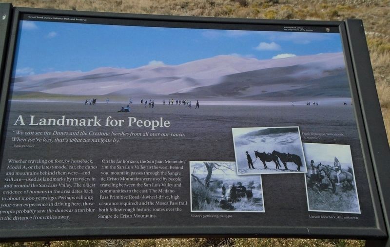
Whether traveling on foot, by horseback, Model A, or the . . . — — Map (db m71051) HM
"Totally Unique and Unexpected!"
—park visitor
Welcome to the high elevation desert that is Great Sand Dunes! Does this landscape strike you as amazing, bizarre or totally out of place. If so, you’re not . . . — — Map (db m71050) HM
The scale of the Great Sand Dunes can be difficult to judge. The dunes you see from here are only the front lines of a sea of dunes that covers many square miles.
How far do the dunes extend into the distance? The dunes are 8 miles (13km) . . . — — Map (db m104717) HM
Different Life Zones Exist in the Mountains
Imagine climbing the mountain in front of you. You might notice it gets cooler as you ascend. As the temperature drops, moisture in the air condenses, precipitation increases, and creates different . . . — — Map (db m71056) HM
You are about to step into the Great Sand Dunes Wilderness. Its mood changes with the seasons, from the spacious solitude of winter, to spring and summer fun and play. Whatever the season of your visit, this unexpected wilderness offers . . . — — Map (db m71057) HM
Mountains and passes were important in the formation
of the sand dunes.
You are looking at the Sangre de Cristo Mountains. Prevailing southwesterly winds carrying sand across the San Luis Valley were blocked by the mountains.
As the . . . — — Map (db m71055) HM
You are looking across a sandy grassland that is a vital part of the Great Sand Dunes geological system. The sand sheet lies between the dunefield and the sabkha. Its deepest portions may be remnants of an ancient lake system, but the surface is . . . — — Map (db m160700) HM
Pagosa Springs has a rich history, beginning with the Anasazi Indians. Later the Utes, Navajos and Apaches inhabited this beautiful corner of the Southwest. They also visited the great “Pagosah” hot springs which they believed had . . . — — Map (db m27527) HM
This ancient tree was once part of a grove of native cottonwoods under which the local Ute Indians would camp and hold council prior to 1881. An Indian trail passed nearby. It has been identified as the Ute Council Tree since 1930, when the local . . . — — Map (db m119897) HM
Down 17th Street, Longs Peak is visible over the roof of Union Station. Together, they symbolize two bases of Denver's economy. Since its founding in 1858, Denver has taken advantage of its location for freight and passenger transportation. . . . — — Map (db m135104) HM
Long’s Peak, visible at the end of 17th Street, is 14,255 feet in elevation.
The National Forest Service lists 54 peaks over 14,000 feet in elevation within the state of Colorado. Mt. Elbert at 14,433 feet it the highest peak in the Rocky . . . — — Map (db m135531) HM
A geologic phenomenon known as a “glowing avalanche” formed Castle Rock and the other buttes of Douglas County 36.7 million years ago. A volcanic eruption near Mount Princeton, about 95 miles southwest of here, spewed a frothy, gleaming . . . — — Map (db m46142) HM
This mountain, 14,110 feet above the sea and the most celebrated peak in America, is named for the explorer, Capt. Zubulon M. Pike, who saw it first in 1806. He attempted to climb it, failed and reported it unclimbable. Ascended in 1820 by Dr. . . . — — Map (db m4846) HM
Imagine standing here in a tropical hardwood forest 55 million years ago. The forest and ancient soils were later covered by white sandstone of uplifted and later eroded Pikes Peak Granite. The sandstone is known as the Dawson Arkose Formation. Its . . . — — Map (db m135458) HM
The Rocky Mountains are the longest chain of mountains in the world. They divide the United States watershed between the Atlantic and Pacific Oceans. Colorado has 53 peaks over 14,000 feet. One inch on the Horizon equals about 38 miles. — — Map (db m4838) HM
Pikes Peak
You are at 13,380 feet, 4,078 meters
Feeling Spacey? In the United States you can not get much closer to outer space than this! Are you dizzy and short of breath? No wonder, you are 2.5 miles (4 kilometers) above sea level! There is 40% . . . — — Map (db m45815) HM
Has been designated a Registered National Historic Landmark under the provisions of the Historic Sites Act of August 21, 1935 this site possesses exceptional value in commemorating and illustrating the history of the United States. US Department of . . . — — Map (db m45816) HM
Passage from prairie to high plains
If you had been standing on this spot for the last 10,000 years, you would have seen the history of Colorado progress below you. This ancient route through the Rocky Mountains is named for Colorado’s Ute . . . — — Map (db m45761) HM
In 1879, General William Jackson Palmer, the founder of Colorado Springs, convinced his friend, Charles Elliot Perkins to purchase land in Garden of the Gods. Perkins eventually bought a total of 480 spectacular acres surrounding the Gateway Rocks, . . . — — Map (db m135547) HM
In 1879, General William Jackson Palmer, founder of Colorado Springs, convinced his friend Charles Elliot Perkins to purchase land in Garden of the Gods. Perkins eventually bought a total of 480 spectacular acres surrounding the Gateway Rocks, . . . — — Map (db m135646) HM
The beauty of Garden of the Gods Park, with its dramatic red rock formations framing Pikes Peak, serves as a magnificent eastern gateway to Colorado’s Rocky Mountains. The park’s towering red sandstone rocks have long been recognized as a landmark. . . . — — Map (db m45983) HM
Around 300 million years ago, the Ancestral Rockies once stood here. Over time, the forces of wind and water eroded the magnificent peaks into swift streams full of sediments. These sediments were eventually pressed and cemented into solid rock. The . . . — — Map (db m45979) HM
Given to
the City of Colorado Springs
in 1909
by the children
of
Charles Elliott Perkins
In fulfilment of his wish
that it be kept forever
free to the public — — Map (db m135023) HM
This rock formation, called Sentinel Rock, is a geologic treasure. It is composed of two types of rock - a fine sandstone and a gravelly conglomerate. The various layers in this rock were deposited 275 million years ago. During that time, ancient . . . — — Map (db m135022) HM
Lt. Zubulon M. Pike and his men, who traveled through this area in November and December 1806, were the first American explorers to view the Arkansas River Canyon now known as the Royal Gorge. A small party from the Maj. Stephen H. Long expedition . . . — — Map (db m34858) HM
From Vision to Reality
Glenwood Canyon has been a critical link in the nation's ground transportation network ever since the completion of the Denver & Rio Grande Railroad in 1887. Later, Taylor State Road, a continuous wagon road between . . . — — Map (db m120263) HM
The Vision
The year was 1886. Walter Devereux, a wealthy silver mining venture capitalist from Aspen, turned his vision downvalley to Glenwood Springs to develop the next world
class resort. The area's climate, rich land, rivers and free . . . — — Map (db m120130) HM
In 1905, Colorado state senator Edward T. Taylor said, "I hope that someday our road will be a portion of a grand boulevard stretching across the nation." Taylor referred to the 12.5-mile gorge known as Glenwood Canyon. Today, the canyon road is the . . . — — Map (db m120136) HM
Glenwood Canyon inspired the finest hour in American rail travel. During World War II a railroad official rode through here in the cab of a diesel freight locomotive. The view from the panoramic windshield so impressed him that he began steps to rig . . . — — Map (db m120140) HM
The Dillon Pinnacles are one example of many spires found within Curecanti. Pinnacles are a product of erosion. Wind, rain, and ice are carving away at the landscape. This process happens everywhere, so why does the rock here form pinnacle shapes? . . . — — Map (db m158868) HM
Here, in the shadow of the Spanish Peaks and the Wet Mountains, stands El Huerfano - "the orphan." This stark and lonely volcanic outcrop, named in the late 1700s by an unknown Spanish trader, had for centuries guided earlier Hispanos and . . . — — Map (db m97717) HM
Clear Creek is one of the most popular and historic waterways of the Front Range. The Clear Creek watershed covers approximately 1550 square kilometers (600 square miles), includes five counties, and more than thirteen communities. From the . . . — — Map (db m49896) HM
The history of Golden reflects the history of Clear Creek. Eons ago, this creek, then a raging river, coursed its way through the mountains, cutting out the canyon and leaving behind fertile soil where an abundance of plants provided food for wild . . . — — Map (db m49908) HM
This is part of the Morrison Formation accumulated around 150 million
years ago. Monsoonal (seasonal) rains caused flooding which dotted the terrain
with small lakes, ponds, and braided streams. These served as watering holes
in the drier times. . . . — — Map (db m125152) HM
Mountain-building processes generate massive pressures in
the earth’s crust. Such pressures cause the rock layers to tilt, buckle,
or fold and sometimes to break or crack. In addition to the obvious tilting of rocks
along the Dakota Hogback, . . . — — Map (db m125154) HM
The high mountains west of here are the beginning of the Rocky Mountains.
They are made up of resistant Precambrian granite and gneiss. The prominent red rocks
in Red Rocks Park are the Fountain Formation, a series of sandstones and . . . — — Map (db m125055) HM
A volcano erupted hundreds of miles from here and ash from the volcano
blanketed this area, which was a swampy environment. Subsequent burial,
compaction, and chemical alteration led to this four inch white to rusty orange
colored claystone . . . — — Map (db m125321) HM
•Colorado’s geologic history dates back nearly two billion years. Several mountain ranges have been uplifted and eroded away before the rise of today’s Rocky Mountains. The landscape you see in front of you has undergone many dramatic changes. This . . . — — Map (db m46438) HM
•This diagram illustrates the features you can see from here. North and South table Mountains are remnants of ancient lava flows now separated and eroded by Clear Creek. The Dakota Hogbacks on the left and right sides of the image were one . . . — — Map (db m46439) HM
You are looking out over the edges of tilted and eroded layers of sandstone and shale that lie upon much older rocks in the mountains behind you. If the eroded layers were restored to where you stand they would be more than two miles thick. The . . . — — Map (db m57932) HM
The "great divide" separates drainage to the Atlantic
from drainage to the Pacific. It traverses America from
Alaska almost to Cape Horn.
Atlantic Ocean
«« drainage
Cache La Poudre Creek
drains into the Platte River
which flows to . . . — — Map (db m89106) HM
Panel 1
Welcome to Colorado
Colorado's vast plains, rugged mountains and grand plateaus, so magnificent in their beauty and variety seem at times to overshadow the state's history and people. But look closely. The . . . — — Map (db m97739) HM
The rocks that make up this landscape formed in environments that are very similar to ones we can observe on the earth's surface today as well as ones that occur beneath the surface where tectonic plates collide to form mountain ranges.
Kayenta . . . — — Map (db m159711) HM
While this might look like a glacial U-shaped valley, it is not. It is a canyon formed by flowing water. The story is one of different rocks responding to erosion in different ways.
Hanging Canyon
Notice how the profile of this canyon . . . — — Map (db m159762) HM
Take the short stroll to a spectacular and unique viewpoint to discover more about the Monument's geology and high flying birds.
Bird Habitat
The airspace above the protected canyons is the domain for a diverse variety of birds.
The Oldest . . . — — Map (db m159709) HM
Erosion produces unusual shapes on the landscape. As the protective Kayenta Formation layers erode from the ridge before you, the softer Wingate Formation beneath it is exposed and responds in a unique way. Early visitors throught these shapes . . . — — Map (db m159759) HM
Water! Every drop has a destiny via the continent’s backbone: the Continental Divide.
With a foot on each side of the bronze line below, you are symbolically straddling the spine of the Western Hemisphere. In North America the Divide follows . . . — — Map (db m71660)
Over a billion years ago, molten rock was squeezed into fissures forming the light-colored bands which thread Black Canyon's otherwise dark walls. You are standing on one of these bands. As the hot fluid slowly cooled and hardened, minerals formed . . . — — Map (db m158993) HM
At 2300 feet, Painted Wall is the highest cliff in Colorado. If the Empire State Building stood on the canyon floor, it would reach slightly more than halfway to the top of the cliff.
The patterns that inspired the name Painted Wall were created . . . — — Map (db m159001) HM
It took bold men to ride into a bold land—a land of raging rivers,
burning deserts, towering mountains, and rugged canyons.
The land of the Southwest through which Dominguez and
Escalante travelled in 1776 was awesome in beauty and . . . — — Map (db m120226) HM
You are standing at the Ouray Fault, the first step in the formation of Box Cañon Falls. Millions of years ago a deep crack in the earth caused the harder rocks to move upward, while the soft sedimentary rocks to the north moved downward. As you . . . — — Map (db m191376) HM
In front of you is one of the largest fossils in the park, a massive petrified redwood stump. The Big Stump is all that remains of a redwood tree that may have been more than 230 feet (70 meters) tall and 500-1,000 years old when the lahar buried . . . — — Map (db m240556) HM
Explosive volcanic eruptions, a quiet freshwater lake, towering redwoods. A picture of this valley 35 million years ago is revealed by studying the rocks that are here today. — — Map (db m93087) HM
Florissant Fossil Beds National Monument safeguards a buried treasure: one of the world's richest fossil deposits. Look around. This 6,000 acre open space belongs to all of us—and to future generations. But what if instead of a public resource, it . . . — — Map (db m240551) HM
On these widespread plains blown clean by the wind and rains large herds of buffalo roamed and gained in number. Then the warriors of Indian tribes hunted them for food and skins. Later white men came to trap beaver in the prairie channels and the . . . — — Map (db m119615) HM