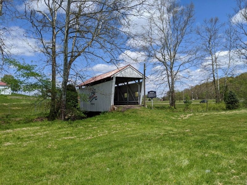
The Mill Branch Covered Bridge spanned the Mill Branch of the Little Hocking River, 0.3 mile East of Ohio 339 in Belpre Twp. This 19th Century "multiple king post" truss bridge
consisted of one span of 59', with 5' overhang at each end, 12' of . . . — — Map (db m149733) HM
As a shareholder of the United Library Association in Pomfret, Connecticut, General Israel Putnam amassed a large collection of books, which was called the Putnam Family Library. The collection was divided among his heirs after his death in 1790. . . . — — Map (db m20129) HM
Washington County Children’s Home, Ohio’s first, and in 1867 the nation’s first supported by taxes, was founded in 1858 by Catherine Fay Ewing at her farm home in Moss Run, Ohio. — — Map (db m103721) HM
The origin and disappearance of the prehistoric Moundbuilders has long been shrouded in mystery. "Conus" is the burial place of chieftains. The mounds and earthworks were constructed between 800 B.C. and 700 A.D. These early inhabitants . . . — — Map (db m314102) HM
Ephraim Cutler (1767-1853) arrived in Marietta from Connecticut in 1795. Prominent in southeast Ohio, Cutler was appointed judge of the court of common pleas and justice of the peace, surveyed land for the Ohio Company, and was a trustee of Ohio . . . — — Map (db m103728) HM
Hagerstown was bypassed in the great race westward between the Chesapeake and Ohio Canal and the Baltimore and Ohio Railroad. The City was left without a rail connection to the south or west. The “Washington County Railroad” was . . . — — Map (db m129270) HM
With a mission to protect citizens at home and abroad, the Ohio National Guard was originally established as the Northwest Territory Militia in Marietta on July 25, 1788 and has fought in every war since the War of 1812. Built in 1914, this Ohio . . . — — Map (db m224966) HM
Gettysburg • Mission Ridge • Shiloh • Corinth • Antietam
Erected in memory of the soldiers of Washington Co. Ohio, who lost their lives in the U.S. service in the war for the suppression of the rebellion of 1861.
Washington County was . . . — — Map (db m209287) WM
Coventry Township. The land on which Coventry Township is situated was ceded in 1785 to
the United States by the Delaware, Chippewa, Ottawa, and Wyandot tribes under the Treaty of Fort McIntosh. The area was a choice location for Native . . . — — Map (db m277653) HM
Underground Railroad Crossings
Underground Railroad crossings, agents, and conductors were common along the Ohio River between Washington County, Ohio and Wood County, Virginia. At Constitution, six miles upriver from Belpre, Judge Ephraim . . . — — Map (db m20130) HM
Muskingtum River Underground Railroad
People living in Marietta and along the Muskingum River shared a history of slavery opposition. Manasseh Cutler, from Massachusetts and an Ohio Land Company agent, helped draft the Ordinance of 1787 that . . . — — Map (db m21653) HM
The Fight for Freedom
The home of John and Susan Eells once stood at this location, 508 Putnam Street, in Marietta. The family moved into the house in 1856 bringing with them a strong hostility to the institution of slavery. Marietta's . . . — — Map (db m301939) HM
This exhibit was designed to honor the men and women who have dedicated their lives to the local surface coal mining industry and to recognize the remarkable and breathtaking achievements in mine reclamation that have taken place here.
For . . . — — Map (db m283628) HM
Side A
Richardson was born on May 25, 1824 in Washington County, PA. He graduated from Washington College in 1844 and moved to Ohio to be a teacher. In 1846 he enlisted In the Third Ohio Infantry and served in the Mexican War. He was . . . — — Map (db m143587) HM
Side 1
Cornelius D. Battelle, Methodist Circuit Rider
Cornelius D. Battelle was born July 13, 1807 in Washington County, Ohio. He entered the Methodist Episcopal Church on October 30, 1825 and the Pittsburgh Methodist Conference in . . . — — Map (db m78493) HM
On July 8, 1910 Deputy Marshal Carl Etherington was killed
for enforcing the County Option Law, which prohibited the
sale of alcohol in Licking County. The County Option Law
was a result of the Rose Law of 1908 and a precursor to
the National . . . — — Map (db m117887) HM
In recognition of the Patriotism of the People of Washington County who so generously purchased War Savings Stamps in 1918 this tablet is gratefully erected by the Ohio War Savings Committee — — Map (db m209240) HM
[Marker Front]:
The Lewis and Clark Expedition
Meriwether Lewis arrived in Marietta on September 13, 1803. His descent of the Ohio River aboard a keelboat began his expedition to explore the West. Included among his crew was 18-year . . . — — Map (db m20741) HM
Washington District 1776; the first governmental division ever named in honor of George Washington; Washington County 1777; Jonesborough established by N.C. Act of 1779 laid out 1780; Capital of State of Franklin 1784-1785; Judicial Capital . . . — — Map (db m83153) HM
Major Edward P. Byrne
Commander of the Confederate Artillery
A native Kentuckian, Byrne was living in Greenville, Washington County, Mississippi, when the war broke out. His first battery of six brass field pieces, their carriages, and . . . — — Map (db m133838) HM
During the first 18 months of the Civil War, President Abraham Lincoln chose not to act upon recommendations of Frederick Douglass, and others, to enlist Black men in the Union Army in the fight against the Confederacy. After the much-needed Union . . . — — Map (db m314862) HM
Production of grindstones was big business in Ohio during the 1800s and early 1900s, when they were shipped all over the world. The large grindstone here was cut from Permian-age sandstone in the vicinity of Marietta, Washington County. The best . . . — — Map (db m280882) HM
Side A:
A tavern and inn, for which Noble Landon (1783-1866) obtained a liquor license in 1835, formerly occupied the southeast corner of High and Main streets. In 1837 Landon and William Yantis laid out the town of New Albany in 50-by-100-foot . . . — — Map (db m14452) HM
In memory of
The Founders Of Cambridge
June Second 1806
and of the pioneers of this region.
Northwest Territory 1787 •
Washington County 1788 •
Survey of Military Lands 1796 •
This 4000 acre tract patented 1801 •
State of . . . — — Map (db m209849) HM
Born on September 28, 1769 in New Bedford, Massachusetts, Bathsheba Rouse is recognized as the first woman to teach in the Northwest Territory. Rouse arrived in the region along with other pioneers in 1788. The following year, the Belpre community . . . — — Map (db m20083) HM
The Kiwanis Club of Marietta
has provided this Lookout Point
so that you who visit here might
better view, understand, and
appreciate the scenic panorama.
of this beautiful and historic
community.
To our guests we extend a most
cordial . . . — — Map (db m209380) HM
A.A. Guthrie chairs the second State Abolition
Society Meeting in Granville, Ohio,
serving as society president. This
meeting also has to contend with
mob violence. — — Map (db m280752) HM
Sullivan County was established by the North Carolina Assembly’s October 1779 session; its north of the Holston River section formerly in Washington County, Virginia; and its south of the river section formerly in Washington County, North Carolina. . . . — — Map (db m69711) HM
Brothers George and Chester Marshall founded Marshall Brothers in 1887. Incorporated as Marshall Nurseries in 1916, the tree nursery survived for more than a century, bringing prosperity to Arlington and influencing horticulture throughout the . . . — — Map (db m287995) HM
The Birth Place
The birth of Ohio's petroleum industry began in south-
eastern Ohio in 1814 near the village of South Olive,
not too far from here. They weren't looking for oil... they
were drilling a well for brine (salt water). Pockets . . . — — Map (db m166303) HM
Have you ever wondered?
In a city with nearly equal numbers of Black and white residents, why is Ward 3's population 70% white and 8% Black?
Since at least the 1700's, Black people have lived and thrived in the area, . . . — — Map (db m259716) HM
Fort Cumberland was garrisoned from 1754 to 1765. During this period, there was bickering between Maryland and Virginia as to how the fort should be maintained and whose control it was under.
In early 1756, Colonel Washington favored a small . . . — — Map (db m17708) HM
At this intersection, President Abraham Lincoln spoke from a railroad car platform to Frederick residents assembled in the streets on October 4, 1862. He had just returned from viewing the battlefields of South Mountain and Antietam and had . . . — — Map (db m60166) HM
The mountains provided Gen. Robert E. Lee with cover. As his army of 75,000 men and 272 pieces of artillery rumbled north through Washington County, the U.S. Army commander did not know his whereabouts because South Mountain, to the east, shielded . . . — — Map (db m39310) HM
Sculpted for Marietta's Sesquicentennial by Gutzon Borglum
——————————
Dedicated July 1938 by President Franklin D. Roosevelt as a tribute to those farsighted pioneers who journeyed here . . . — — Map (db m20674) HM
It took a lot of clams (among other marine invertebrates) to make up the Ames Limestone bed, which extends westward into Ohio and eastward through Pennsylvania. Evidence of the vastness of the sea is shown in the speculative map.
This map at . . . — — Map (db m248323) HM
Prior to 1800 Beaver County did not exist as we know it today and was, at various times, part of several other much older counties.
On March 12, 1800, Beaver County was officially formed from parts of Allegheny and Washington Counties. The Borough . . . — — Map (db m176917) HM
On Thursday, November 24, 1864, the 14th and 20th Corps of Union Major General William T. Sherman's army began entering Washington County. By November
26th the 28,000 soldiers of the two corps arrived in Sandersville, marching on separate roads . . . — — Map (db m103235) HM
Pioneer Spirit
The westward movement was an enticement felt by many nineteenth century families, and the Lincolns were in the heart of it. A friend of the family was the infamous frontiersman Daniel Boone, and it has been reasoned that . . . — — Map (db m46249) HM
Cyrus Livingston Dunham left a promising political career to serve his country in the Civil War. He resigned his military commission November 18, 1863, his health broken
A Rural Upbringing
Cyrus Dunham was born and raised on a farm . . . — — Map (db m174108) HM
The Lewis & Clark Expedition, known as the Corps of Discovery Expedition, was the first American expedition to cross the northwestern portion of the United States. On May 14, 1804, the Corps – consisting of 33 men – departed from St. Louis for the . . . — — Map (db m210068) HM
The St. Stephens Historical Commission was chartered by the State of Alabama in 1988: The board is charged with "acquiring, maintaining, protecting, promoting, and preserving" Alabama's first capital, St. Stephens.
Washington . . . — — Map (db m294044) HM
Marvil Starlin, Sr. (1771-1852) received 100 acres of free land (Lot 6) in
the Allotment between Rainbow and Waterford in the Donation Tract.
A 1798 Waterford Township tax enumeration by Lt. Joseph Frye in
Special Collections at Marietta College . . . — — Map (db m313379) HM
To the memory of the soldiers of the American Revolution buried in Washington County, Ohio, whose graves are unknown.
Allen Asher (1746-1840) •
Hugh Allison (1747-1824) •
Robert Allison (1755-1812) •
John Amlin (Died 1816) •
Caleb Barstow . . . — — Map (db m313798) HM
Between June 9, 1856, and July 6, 1860, ten separate Handcart Companies left Iowa
City, Iowa, or Florence, Nebraska to their land of Zion in the Utah Territory. There were
653 handcarts and 50 wagons.
Nearly 3,000 souls, some with babes in . . . — — Map (db m59369) HM
Dedicated to the
Soldiers and Sailors of the
United States
Enlisting or Residing in
Washington County
———
Erected by the Citizens of
Washington County
1916
center panel
Minnesota
Alcorn James 2nd Cav. •
Barrisford . . . — — Map (db m72153) WM
Thin black lines indicate changes in relevance. Between each pair of lines entries are ordered geographically but all have the same relevance.
* Inflectional forms of words are their plurals, singulars, and possessives as well as gramatical tenses and similar variations.