783 entries match your criteria. Entries 101 through 200 are listed.⊲ Previous 100 — Next 100 ⊳
William G. Pomeroy Foundation Historical Markers
Since its inception, the Foundation has grown to six historic signage programs, funding over 1,000 markers & plaques in New York, Ohio and beyond, all the way to Alaska. Does not include the William G. Pomeroy Foundation Legends & Lore Series.
On Olive Street at North Beaumont Street, on the right when traveling east on Olive Street.
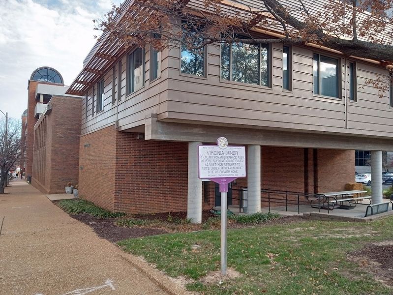
Pres., MO Woman Suffrage Assn. In 1875, Supreme Court ruled against her attempt to vote under 14th Amendment. Site of former home. — — Map (db m223347) HM
On South 4th Street just south of Lewis Avenue, on the right when traveling north.
Delphine Squires and the Mesquite Club sponsored suffrage speakers 1912-1914. Club met at the Las Vegas school on this site until 1915. — — Map (db m213132) HM
On Main Street (U.S. 50) at Virginia Hill, on the right when traveling west on Main Street.
Frances Williamson, a teacher, helped found and lead the Austin Equal Suffrage League and the Nevada Equal Suffrage Association in 1895. — — Map (db m213135) HM
On Main Street (U.S. 6/95) at Brougher Avenue, on the right when traveling north on Main Street.
Marjorie Moore Brown worked for Nevada's vote & the Nineteenth Amendment. Suffrage meetings held here at Mizpah Hotel 1912-1914. — — Map (db m223914) HM
On June 22, 1825, General Lafayette was received by the State Legislature in the State House. He returned on June 27, 1825 heading west. — — Map (db m236852) HM
On Portsmouth Avenue at Post Road (New Hampshire Route 151), on the left when traveling west on Portsmouth Avenue.
On Sept. 1, 1824, General Lafayette was received by the citizens of Greenland at a triumphal arch erected in front of the local hotel. — — Map (db m186251) HM
On Opera House Square at Pleasant Street (New Hampshire Route 11/12), in the median on Opera House Square.
On June 27, 1825, General Lafayette was greeted by crowds & 13 gun salute. He stayed at Stevens' Hotel, and left the next morning for VT. — — Map (db m230224) HM
On Sycamore Avenue (County Road 13A) at Broad Street (State Route 35), on the right when traveling east on Sycamore Avenue.
Shrewsbury Historic District has been placed on the National Register of Historic Places in 1978 by the United States Department of the Interior — — Map (db m209046) HM
On Halter Road just west of River Road (New York State Route 144), on the right when traveling west.
Former estate of Judge Elisha Powell Hurlbut. Wrote "Rights of Woman" essay in 1841. Served on state suffrage committee 1880-1882. — — Map (db m223915) HM
On Picard Road (County Road 307) 0.2 miles north of Tygert Road, on the left when traveling north.
Jacob Cooper farm site nearby robbed by Loyalists June 1779. Investigated here by Patriot Commissioners for Detecting and Defeating Conspiracies. — — Map (db m248676) HM
On North Main Street just north of Saxon Drive, on the right when traveling north.
Abigail Allen, 1824-1902. Early suffragist, reformer, & Alfred University educator declared "Be radical, radical to the core” in 1873 speech — — Map (db m171918) HM
Near Main Street (New York State Route 120) at Bartlett Road, on the right when traveling north.
Used as a burial ground for pioneer families: Lesuer, Tyler, Cowles, Kellogg, Mead, Daniels, Beers, Davie stones date from the 1820's. — — Map (db m88284) HM
On Main Street (New York State Route 417) 0.1 miles south of Foreman Hollow Road, on the right when traveling north.
Early settler Eli Lesuer bought this property 1834. Elected 1st town assessor 1825, school commissioner 1834, and path master 1846. — — Map (db m88283) HM
On Pine Street at Carroll Street, on the left when traveling west on Pine Street.
Alfred Dunk House has been placed on the National Register of Historic Places in 1985 by the United States Department of the Interior — — Map (db m198185) HM
On Court Street, on the right when traveling west.
Phelps Mansion Museum
has been placed on the
National Register of
Historic Places 1973
by the United States
Department of the Interior — — Map (db m92921) HM
On Main Street (New York State Route 17C) at Oak Street, on the left when traveling east on Main Street.
Trinity Memorial Episcopal Church has been placed on the National Register of Historic Places in 1998 by the United States Department of the Interior. — — Map (db m198201) HM
On New York State Route 26, on the left when traveling north.
Grist mill founded ca. 1830
by H.B. & Daniel Slosson.
Owned by A. Pitcher 1920-1949,
closed in 1955. Donated to
historical society in 1988. — — Map (db m132753) HM
Native American village near mouth of Big Choconut Creek. Destroyed by General Enoch Poor August 18, 1779, Clinton-Sullivan Campaign. — — Map (db m127570) HM
Pioneer Alfred Rounds and some of his descendants are buried in this stone-walled family cemetery on land son Jacob purchased in 1825. — — Map (db m127574) HM
On Vestal Parkway East, on the right when traveling east.
Built 1881 in Carpenter
Gothic style for D.L. & W.
Railroad. Moved to this site
in 1972. Restored and
reopened as museum in 1976. — — Map (db m128008) HM
Parkway style highway
built 1941. Completed 1951.
Led to rapid development
along what became Vestal's
"$50 Million Main Street." — — Map (db m133061) HM
Burials 1810-1934
David & Phebe Willis arrived
in Willow Point CA. 1796,
Elias Willis owned local tavern.
Buried here with family. — — Map (db m127997) HM
On Church Road, 0.1 miles south of Cherry Valley Road, on the right when traveling south.
Civil War private buried here. Died in 1863 from wounds rec'd at Chancellorsville. Subject of Walt Whitman's 1864 essay "A New York Soldier". — — Map (db m132668) HM
On Jefferson Street (U.S. 219) 0.2 miles south of Martha Street, on the left when traveling south.
Jefferson Street Cemetery has been placed on the National Register of Historic Places in 2012 by the United States Department of the Interior — — Map (db m89102) HM
On Salamanca-Sugartown Road (New York State Route 98) at Humphrey Road, on the right when traveling north on Salamanca-Sugartown Road.
Built ca 1856 at junction of Ellicottville-Great Valley Plank Road & road to Franklinville. Served as hotel, livery & post office — — Map (db m95789) HM
On U.S. 62, 0.1 miles north of Cherry Creek Hill Road (County Route 6), on the right when traveling south.
Leon Grange has been placed on the National Register of Historic Places in 2014 by the United States Department of the Interior — — Map (db m133013) HM
On U.S. 62 at Cherry Creek Hill Road (County Route 6), on the right when traveling south on U.S. 62.
Leon United Methodist Church has been placed on the National Register of Historic Places in 2000 by the United States Department of the Interior — — Map (db m133018) HM
On Court Street at 7th Street, on the right when traveling east on Court Street.
Bldg. dedicated Sept. 7, 1914 to honor the nearly 3,500 Cattaraugus County citizens who served in the Army and Navy during the Civil War. — — Map (db m132670) WM
On North Center Road, 0.1 miles north of Palmer Road, on the left when traveling north.
Early School The North Lyndon school was built ca. 1844 and remained in use until 1947. The school still retains many of its original features. — — Map (db m86611) HM
On East State Street (New York State Route 417) east of South Union Street, on the right when traveling east.
Harriot Stanton Blatch, Pres. NYS Women's Political Union held suffrage liberty torch rally here July 1915 for women's right to vote — — Map (db m153623) HM
On North Division Street at Beech Tree Road on North Division Street.
1941-1952 built by the
flying farmers: Leman Ingalls,
Hugh Darrow, Ralph Bower,
Frank Nugent. Offered
lessons and charter flights — — Map (db m133053) HM
On South Street (New York State Route 34) south of Grover Street, on the right when traveling south.
Dedicated Nov. 15, 1888 on land given to city by Seward family. Bronze statue depicts William H. Seward delivering "Higher Law" speech to Senate — — Map (db m226039) HM
On Genesee Street west of South Street (New York State Route 34), on the right when traveling east.
Headquarters of the Cayuga County Political Equality Club here 1914-1916. Founded 1891. Championed women's suffrage until won in New York in 1917. — — Map (db m226059) HM
On Chapman Road, 0.3 miles west of High Street, on the right when traveling south.
Early Aqueduct This towpath leads to the Richmond Aqueduct built 1849 second largest aqueduct carrying Erie Canal waters over the Seneca River. — — Map (db m83562) HM
On New York State Route 90, 0.1 miles north of Erie Street, on the left when traveling north.
Early Cemetery Old Montezuma Cemetery Revolutionary War veteran Richard Damewood buried here 1850. Served at seige of British at Yorktown. — — Map (db m83546) HM
On McDonald Road (County Route 114A) at Mentz Church Road (County Route 115), on the left when traveling east on McDonald Road.
First Methodist Episcopal Church Inc. 1825 with John Gilmore, Wm. Bell & James Weston, Trustees. Adjoining cemetery in use by 1813. — — Map (db m83525) HM
On High Street at Erie Street, on the left when traveling north on High Street.
Opened in 1828 Cayuga Seneca Canal Extended navigation of the Erie Canal to Finger Lakes Site of crossover bridge and Exchange Hotel — — Map (db m83547) HM
Town of Sodom was renamed in 1823 by man who climbed the ridgepole of the gristmill, christened it with whiskey, said village had new hope. — — Map (db m246510) HM
Port Byron native gifted bible to Pres. Abraham Lincoln in 1861. Received letter of thanks from John Nicolay, Lincoln’s private secretary. — — Map (db m230540) HM
On Turnpike Road (County Route 10B) 0.1 miles west of Lewis Road, on the right when traveling east.
Settlers used Owasco River power to run sawmills & gristmills as early as 1798. This site was one of the three dams built in Throop. — — Map (db m87937) HM
On Liberty Street, 0.1 miles east of S. Seneca Street, on the left when traveling east.
First Baptist Church of Weedsport has been placed on the National Register of Historic Places in 2003 by the United States Department of the Interior — — Map (db m157012) HM
On West Main Street (U.S. 20) at Highland Avenue, in the median on West Main Street.
Has been placed on the National Register of Historic Places in 1996 by the United States Department of the Interior.
Brocton Arch Erected 1913
With unprecedented growth of the village, the Village of Brocton and Town of Portland wanted . . . — — Map (db m96609) HM
Near Chautauqua Avenue (New York State Route 430) at Creek Road, on the right when traveling south.
Picnic and recreation area opened in 1898 by Jamestown & Lake Erie Rwy. Visitors came via steam train, then by electric interurbans 1914 - 1947. — — Map (db m207727) HM
On Button Valley Road, 1.5 miles west of Blockville-Watts Flats Road (County Route 35), on the left when traveling west.
Roll-O-Bowl On this site 1956-1960 Sunday jalopy races held on quarter mile dirt track. Built by McNitt brothers on their grandmother's farm. — — Map (db m105683) HM
On North Erie Street (New York State Route 394) at East Chautauqua Street (New York State Route 430), on the right when traveling north on North Erie Street.
Spoke at courthouse on this site Dec. 26, 1854 to organize first county women's suffrage convention for NY state Women's Rights committee. — — Map (db m172786) HM
On County Road 60, on the right when traveling west.
The Delaware village near this site included 30 to 40 buildings and farm fields burned by Continental troops on August 13, 1779. — — Map (db m242356) HM
Abolitionist Jervis Langdon
sold house to Daniel R. Pratt
in 1862. Once thought
destroyed, house was moved
here from E. Union St. ca. 1876. — — Map (db m127996) HM
On County Road 60, on the left when traveling west.
Delaware Captain who, with 20-40 Delaware men, defended their homes and land here on August 13, 1779 at the Battle of Chemung. — — Map (db m242357) HM WM
On East Main Street, on the right when traveling north.
Established in 1818 as the Universalist Church burying ground and now called East Side Cemetery. Many early settlers buried here. — — Map (db m230671) HM
On New York State Route 41 at New York State Route 206 on State Route 41.
Simon Jones' stone here was
carved by J.W Stewart 1818.
Local history suggests J.W. is
now known as Coffin Man for
carving many similar stones. — — Map (db m93286) HM
On New York State Route 26, 0.1 miles east of Pitcher Hill Road, on the left when traveling south.
First Congregational Church of Pitcher
has been placed on the
National Register of
Historic Places in 2001
by the United States
Department of the Interior — — Map (db m146742) HM
On Route 26, 0.1 miles east of Pitcher Hill Road, on the right when traveling south.
Pitcher Baptist Church
has been placed on the
National Register of
Historic Places in 2001
by the United States
Department of the Interior — — Map (db m146738) HM
On New York State Route 26 at Clarence Church Road, on the right when traveling north on State Route 26.
South Otselic Historic District has been placed on the National Register of Historic Places in 1983 by the United States Department of the Interior — — Map (db m231801) HM
1906-2012. Daughter of the
Charity of the Sacred Heart
of Jesus sailed from France
in 1905 to start the Academy.
"Tout pour la gloire de Dieu" — — Map (db m132721) HM
On New York State Route 9N, 0.2 miles east of Smith Street, on the right when traveling east.
Prominent for iron industry, one of region’s largest bloomery forges 1833-1890. Used ore from Arnold Hill, Palmer Hill and Winter Mine.
William G. Pomeroy Foundation 2019 • 537 — — Map (db m137824) HM
On North Ausable Street north of Main Street, on the left when traveling north.
Keeseville, Ausable Chasm, & Lake Champlain Railroad, a "peanut" line. Took mail, freight & passengers here to Port Kent from 1890-1924 — — Map (db m132697) HM
783 entries matched your criteria. Entries 101 through 200 are listed above. ⊲ Previous 100 — Next 100 ⊳