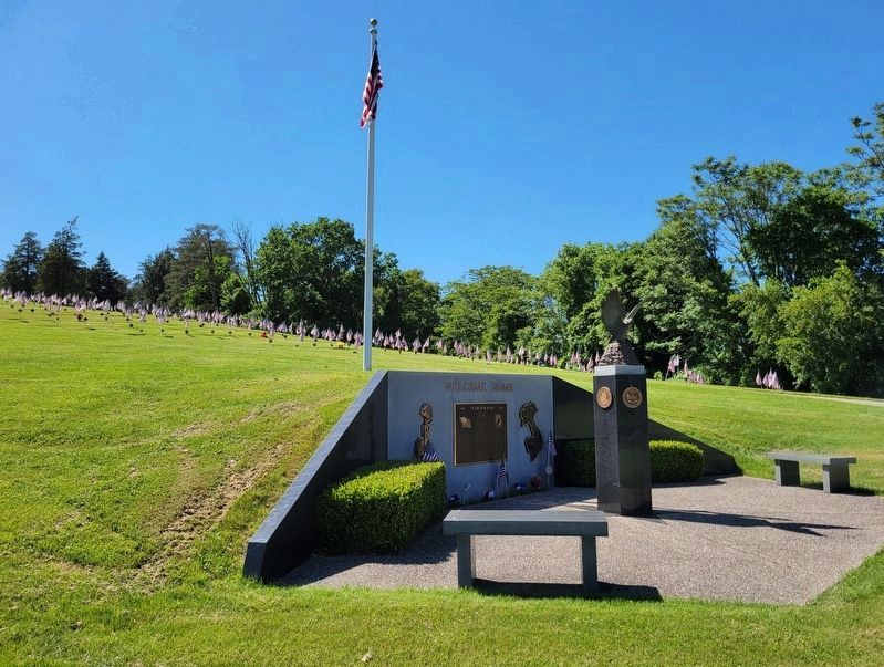
Near Park Avenue (Pennsylvania Route 18) 0.2 miles north of Williams Street, on the right when traveling east.
VIETNAM
1959 • 1975
Remember us - we were just kids - the most of us - not militant, not warriors, and certainly not men but trying just as hard as any can imagine to be so; just ordinary guys like you;
and had we made it home . . . — — Map (db m199325) WM
On South Main Street (Pennsylvania Route 18) at Cherry Way, on the right when traveling south on South Main Street.
Formed March 28, 1781 out of Westmoreland County and named for General George Washington. A scene of activity in the Whiskey Rebellion, 1791-1794. The county seat, Washington, was made a borough in 1810; then a city in 1924. On the National Road, . . . — — Map (db m40410) HM
On Murtland Avenue (U.S. 19) at North Avenue, on the right when traveling south on Murtland Avenue.
Laid out in 1781 by John and William Hoge. Site of Indian Catfish Camp. Boro charter, 1810; city, 1823. National Road center and rich in historic buildings and associations. Named for George Washington. — — Map (db m258) HM
On 2nd Street Extension at Grant Avenue, on the right when traveling west on 2nd Street Extension.
Jacob Rabe came from Maryland in 1770 to Western Pennsylvania while this area was claimed by Virginia. In 1774 he received a Virginia Certificate for 412 acres. Boundary dispute between Virginia and Pennsylvania was settled in 1781, with the . . . — — Map (db m69762) HM
On Franklin Farms Road 0.4 miles south of Franklin Farms Road and US 40, on the right when traveling south.
Here met, in August 1776, under Virginia’s claim to western Pennsylvania, the first court west of the Monongahela River. The site is .2 mile south and marked by a monument. — — Map (db m195504) HM
On 10 Mile Street at County Park Road, on the right when traveling east on 10 Mile Street.
Abraham (1718-1781) and Mary Parker Tegarden from Frederick County, Virginia 1753, made an 'improvement' opposite mouth of Tenmile Creek, Fayette County; Abraham, sutler for Colonel Bouquet 1759, fought in French and Indian War, Captain Virginia . . . — — Map (db m56944) HM
On West Lincoln Avenue (Pennsylvania Route 980) 0.1 miles west of 6th Avenue, on the right when traveling east.
Oil was first struck here in 1890, and in 1891 and 1892 the field yielded the highest levels of oil in the world. Second only in Pa. history to the Bradford Oil Field in both size and production, it was instrumental in achieving the state's highest . . . — — Map (db m58541) HM
On Mapleville Rd at Fahrney Church Rd., on the right when traveling north on Mapleville Rd.
Founder of the Fahrney family in Maryland. Born May 8, 1767, in Lancaster County Pennsylvania. Died April 9, 1837. Son of Doctor Jacob Fahrney who was born at Frankfort, Germany, studied medicine, and in the year 1756 came to American and settled in . . . — — Map (db m229241) HM
On Greencastle Pike (Route 63), on the right when traveling north. Reported missing.
The mountains provided Gen. Robert E. Lee with cover. As his army of 75,000 men and 272 pieces of artillery rumbled north through Washington County, the U.S. Army commander did not know his whereabouts because South Mountain, to the east, shielded . . . — — Map (db m39310) HM
On Fox Chapel Road, on the right when traveling north.
It took a lot of clams (among other marine invertebrates) to make up the Ames Limestone bed, which extends westward into Ohio and eastward through Pennsylvania. Evidence of the vastness of the sea is shown in the speculative map.
This map at . . . — — Map (db m248323) HM
Near Buchanan Drive (State Highway 29) at Fort Croghan Drive.
One of "Old 300" of Stephen F. Austin's first colony from Pennsylvania, took part in 1836 War for Texas Independence, he made and lost several stakes.
In 1851 bought a league and labor of Burnet County land, including site of Fort Croghan. . . . — — Map (db m29150) HM
Near Navasota Street at Inks Avenue, on the right when traveling north.
Served in the Army of Texas, 1836 · Born in Pennsylvania Aug. 18, 1818 · Died in Washington County, Texas March 18, 1883 His wife Mary V. (Cooper) Dallas · Born in Tennessee Jan. 22, 1826 · Died in Washington County, Texas June 6, 1875 — — Map (db m167064) HM
On Crockett Street 0.1 miles east of Gay Hill Street, on the right when traveling west.
Jabez Deming Giddings (1814-1878) of Pennsylvania bought this land in 1837. A lawyer, businessman, and civic leader, he built this residence of hand-hewn cypress boards before his marriage in 1843 to Ann Tarver (1822-1907). An unusual rooftop . . . — — Map (db m165316) HM
On Noblestown Road (Pennsylvania Route 980), on the right when traveling east.
The McDonald Oil Field
The "Great Oil Boom Excitement” of 1891
In the early 1890's, just about the time that the commercialization of oil was becoming big business, the Great McDonald Oil Field was the highest producing oil field in the . . . — — Map (db m178928) HM
Near Main Street north of Rices Landing Road (County Route 1010), on the left when traveling north.
Pennsylvania Railroad Company
Established in 1846, the Pennsylvania Railroad Company (PRR) was headquartered in Philadelphia, Pennsylvania. By 1882, it had become the largest railroad and transportation company in the world with a budget . . . — — Map (db m181582) HM
On Main Street (U.S. 40) at the Nemacolin Country Club driveway, on the right when traveling west on Main Street.
(South Face) N.S.D.A.R. Memorial to the Pioneer Mothers of the Covered Wagon Days.
(East Face) On this historic spot, the hunting ground of the friendly Indian Nemacolin, this monument is erected and dedicated to the memory of our pioneer . . . — — Map (db m501) HM
On South Main Street (U.S. 77) at East Richmond Street, on the right when traveling north on South Main Street.
County seat of Lee County. Named for Jabez D. Giddings (1814-78), of Washington County, one of four brothers from Pennsylvania who were Texas transportation pioneers and business leaders.
The town was established as a shipping point when . . . — — Map (db m150321) HM
On State Road 21 3.1 miles west of Old San Antonio Road, on the right when traveling east.
A fur trapper by trade, Daniel Larrison was an early Anglo Texas settler who received a Mexican Land Grant in 1833, which included the area later organized as Madison County. Born in Washington County, Pennsylvania, Larrison served under Zachary . . . — — Map (db m268125) HM
Near West Memorial Boulevard at South Potomac Street.
Jonathan Hager was the founder of the City of Hagerstown. He was born in Germany and immigrated to Pennsylvania in 1736. In 1739, he purchased 200 acres of land in what is now the western part of Hagerstown and engaged in numerous business ventures. . . . — — Map (db m107144) HM
On West Pike Street east of Iron Street, on the left when traveling west.
This home was built in 1895 by Canonsburg industrialist John Budke, 1852-1914. Budke became manager and later the owner of Canonsburg's first major industry. Canonsburg Iron and Steel Company, commonly known as the Budke Mill. He was a pioneer in . . . — — Map (db m198177) HM
On Virginia Creeper National Recreation Trail west of Mountain View Drive, on the left when traveling west.
The Virginia Carolina Railway which is now the Virginia Creeper Trail was originally built to haul timber cut from what is now the Mount Rogers National Recreation Area. It is estimated that between 1907 and 1930 approximately 15 million board feet . . . — — Map (db m211093) HM
On Tanger Boulevard 0.4 miles south of Racetrack Road, on the right when traveling south.
This flag dedicated to Veterans of Washington County who courageously served their country.
God bless America
Tanger Outlet Center
Washington, Pennsylvania
August 29, 2008 — — Map (db m225090) WM
On Rush Creek Road (Local Road 26) at Local Road 32, on the left when traveling east on Rush Creek Road.
Side A
Erected in 1828, the Randolph Mitchell House is a five-bay, Federal-style "I" house. Its facade features a doorway with an Adam-style fan and sidelights. The interior boasts a grand stairway in the foyer and fine woodwork . . . — — Map (db m224972) HM
On West Memorial Boulevard 0.1 miles west of South Potomac Street (Maryland Route 65), on the right when traveling east.
1896
The Hagerstown Railway trolley system begins operation. Service is expanded in 1904 to Frederick and into Pennsylvania, becoming the first inter-urban rural rail system in the country. The last car runs in 1947.
1898
America . . . — — Map (db m145993) HM
On South Mulberry Street south of East Antietam Street, on the right when traveling south.
This property is one of the earliest developed sites in Hagerstown. St. John's Episcopal Church stood here from the 1780s until around 1830, when a new church was constructed on South Jonathan Street (Summit Avenue). When that church burned in . . . — — Map (db m195378) HM
On East End Avenue, on the right when traveling north.
Prior to 1800 Beaver County did not exist as we know it today and was, at various times, part of several other much older counties.
On March 12, 1800, Beaver County was officially formed from parts of Allegheny and Washington Counties. The Borough . . . — — Map (db m176917) HM
On Mingo Church Road west of Route 88, on the left when traveling west.
The Whiskey Rebellion was a tax protest beginning in 1791 during the presidency of George Washington. The Mingo Creek Society, also known as the Whiskey Boys, was especially outraged at a federal tax levied on each gallon of whiskey they produced . . . — — Map (db m205334) HM
Near Panhandle Trail east of South McDonald Street.
Tillinghast Machine Shop
One of McDonald's first and longest enduring local industries. The shop was established in 1892 and operated through the late 1940s by Mr. B. D. Tillinghast, a highly acclaimed mechanical engineer and inventor. The . . . — — Map (db m297325) HM
Near Beechland Road (Kentucky Route 438) at Lincoln Park Road ( Route 528), on the left when traveling east.
President Abraham Lincoln’s great, great, great, great grandfather, Samuel Lincoln, left England in 1637, settling in Hingham, Massachusetts. The next four generations of Lincolns continued to move south and west — to New Jersey, then . . . — — Map (db m46301) HM
Robert Patterson owned a 25-acre tract on the west side of a Catoctin peak. This peak is known today as Bob's Hill. Robert was a free African American collier and pig farmer, one of 22 “mulattos”* listed in the 1870 United States Census for the . . . — — Map (db m260974) HM
On West Memorial Boulevard 0.1 miles west of South Potomac Street (Maryland Route 56), on the right when traveling west.
1912
Thomas Pangborn moves his sand-blast manufacturing business to Hagerstown.
1915
The Maryland Theatre is constructed. The Hagerstown Municipal Band plays its first concert that July in this theater.
1915
The . . . — — Map (db m146065) HM
Born in Pennsylvania in 1824, Margaret Greenawalt was raised in the Greencastle area. By the Civil War, she lived with her sister and brother-in-law, George and Catharine Bowman, in Hagerstown. The Bowmans operated a confectionary (bakery and candy . . . — — Map (db m256130) HM
On Log Cabin Drive, on the right when traveling north.
The Kennedy Log House, administered by the Washington County Historical Society, is just one example of an 18th
century log home. Built in 1848 by Peter Kennedy, the house was originally located at the corner of West Beau and
Franklin Streets in . . . — — Map (db m163712) HM
Thomas Sirls Terry was born in Bristol Township, Buicks County, Pennsylvania, on 3 Oct 1825 to Thomas Sirls and Mary Ann Murkins Terry. Thomas went to work at the age of 7 in a local cotton mill. At 17 he was apprenticed to learn the trade of . . . — — Map (db m14342) HM
On Lakeview Parkway near Shoosmith Road, on the left when traveling north.
During the first 18 months of the Civil War, President Abraham Lincoln chose not to act upon recommendations of Frederick Douglass, and others, to enlist Black men in the Union Army in the fight against the Confederacy. After the much-needed Union . . . — — Map (db m314862) HM
On W. State Street, on the right when traveling west.
Paleo-Indian (14,000 B.C.-8000 B.C.)
Located about 70 miles away,
Meadowcroft Rock Shelter in
Washington County, has suggested
through radiocarbon dating that there
has been occupation in Pennsylvania
as early as 14,000 B.C.
Archaic . . . — — Map (db m202325) HM
On Main Street (Pennsylvania Route 837) at 7th Street, on the left when traveling west on Main Street.
Main & Seventh Streets Monongahela, Pa
has been placed on the
National Register
of Historic Places
by the United States
Department of the Interior
Founded 1833
Steeple
Destroyed by lightning
Sept. 17, 1987 . . . — — Map (db m205834) HM
On Pine Street West at Third Street South (County Highway 23), on the left when traveling west on Pine Street West.
Dedicated to the
Soldiers and Sailors of the
United States
Enlisting or Residing in
Washington County
———
Erected by the Citizens of
Washington County
1916
center panel
Minnesota
Alcorn James 2nd Cav. •
Barrisford . . . — — Map (db m72153) WM
Thin black lines indicate changes in relevance. Between each pair of lines entries are ordered geographically but all have the same relevance.
* Inflectional forms of words are their plurals, singulars, and possessives as well as gramatical tenses and similar variations.