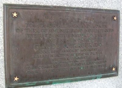
On West Street/Napoleon Road at Lincoln Highway (Ohio Route 696), on the left when traveling north on West Street/Napoleon Road.
Dedicated to those from Beaverdam
& vicinity who served their country in the
war for the liberty of the world
1941 - 1945
To honor all men and women
of this community who nobly served
their country in World War II
and in memory of . . . — — Map (db m29927) WM
On West Main Street (Ohio Route 696) just west of Mill Street, on the left when traveling west.
This memorial is dedicated to all the men an women
who served our country in times of war and peace
so that we might have the freedoms we all love.
Our flag does not fly because the wind moves it.
…It flies with the last breath of each . . . — — Map (db m196214) WM
On East Main Street (Ohio Route 696) at Church Street, on the right when traveling east on East Main Street.
War of 1812 (1812-1815)
Frederick Shull
Civil War (1861-1865)
Milton S. Athey • George W. Bailey • Leonidas Q. Barnhard • Charles W. Coates • John J. Conrad • Amos Criblez • August V. Criblez • Robert Crider • Julius Curtiss • Aaron . . . — — Map (db m282694) WM
On North Pevee Road, on the right when traveling north.
Upon this hallowed ground. Pleasant Hill Methodist Church stood for nearly a century (1887 - 1982) serving well the surrounding community of farm families, many of whose members lie at rest in the adjacent cemetery. — — Map (db m238508) HM
On Bentley Road south of Augsburger Road, on the right when traveling south.
Bluffton University gratefully acknowledges the generosity of the alumni and friends who provided financial support for the Alumni Field project to enhance Salzman Stadium with top-quality game and practice surfaces for student-athletes.
The . . . — — Map (db m248094) HM
On North Main Street north of Vine Street, on the left when traveling north.
First National Bank - 1892-1918
Day Barber Shop - 100+ years
Bluffton Post Office - 1904
Hamp Swank Restaurant - circa 1919
Carter Notion Store 5¢ to 10¢ - circa 1922
Moser-Bixel Ford Floor Mats - circa 1925
Kroger Store - circa 1925 . . . — — Map (db m196221) HM
On East Elm Street east of North Main Street, on the left when traveling east.
Bluffton, Ohio Est. 1861
Celebrating Our Heritage
This fair lady continues to bless our modern & diverse community.
Early explorers & surveyors paved the way for Mennonite homesteads.
Native peoples enjoying Nature's . . . — — Map (db m196224) HM
Near Bentley Road south of Augsburger Road, on the right when traveling south.
Bluffton University Memorial Field and this Circle of Remembrance honor and remember the 2007 Bluffton baseball team, and especially Zachary Arend, David Betts, Scott Harmon, Cody Holp and Tyler Williams, who lost their lives as a result of a . . . — — Map (db m248095) HM
Near Bentley Road south of Augsburger Road, on the right when traveling south.
Cody E. Holp grew up in Verona, Ohio. With a passion for life and family, his motto was to live life to its fullest. He loved all sports with a special passion for baseball and Soccer, and he received numerous awards for both. He was a natural . . . — — Map (db m248099) HM
Near Bentley Road south of Augsburger Road, on the right when traveling south.
David Joseph Betts lived life to the fullest and loved to play and compete. He loved God, his family, his friends and life. He grew up in Bryan, Ohio, and approached everything with his whole heart. A talented musician, he was an honor student and . . . — — Map (db m248097) HM
On West College Avenue south of Rosenberger Road, on the left when traveling north.
J.A. Amstutz, President of the Board • J.E. Lehman • H.J. Krehbiel • J.H. Tschantz • J.W. Leatherman • Gerhard Yogt • P.O. Suter • J.C. Mehl • P.E. Stucky
Reorganized as Bluffton College A. D. 1914 — — Map (db m248118) HM
On East College Avenue at Railroad Street, on the right when traveling east on East College Avenue.
As a freshman Ricky started as quarterback for the 2003 high school varsity football team. Ricky's smiling face and star athletic abilities touched everyone in the Bluffton school district.
Ricky gave us new meaning to "Friday Night Lights . . . — — Map (db m248119) HM
Near Bentley Road south of Augsburger Road, on the right when traveling south.
Tyler LaMar Williams, a young man with a billion-dollar smile, lived a life filled with activity, creativity, family and friends. He grew up in Lima, Ohio, where he excelled in many pursuits including music, sports and business. In high school, he . . . — — Map (db m248101) HM
Near Bentley Road south of Augsburger Road, on the right when traveling south.
Zachary Herman Arend grew up in Oakwood, Ohio, where from the time he was little, he loved playing baseball and being outdoors. He was competitive in sports, including baseball, football and basketball, but with a passion for baseball. In 2006, he . . . — — Map (db m248096) HM
On East Jefferson Street (Ohio Route 103) west of Huber Street, on the right when traveling east.
Dedicated to Jim, John & Fred Herrmann and all Bluffton Veterans of World War II
World War II Veterans that lived in Bluffton, Beaverdam and Richland Township when they served their Country.
Agin, Ivan • Althaus, Cleon • Althaus, . . . — — Map (db m239486) WM
Near Bentley Road south of Augsburger Road, on the right when traveling south.
Scott Graham Harmon was a scholar-athlete from Elida, Ohio, where he played football and baseball and earned district and regional honors in both sports. In high school, he was active in National Honor Society, Fellowship of Christian Athletes and . . . — — Map (db m248098) HM
On Lincoln Highway (U.S. 30) at George Street, on the right when traveling west on Lincoln Highway.
Memorial Park hosted the famous Kansas City Monarchs during a barnstorming tour on August 4, 1961. The home team was the Lima Metro League’s Cairo Merchants. Legendary pitcher Leroy “Satchel” Paige (1906-1982) appeared on the mound for the Monarchs. . . . — — Map (db m230339) HM
On South Conant Road, on the right when traveling south.
WWII 78,000+ Korea 8,000+ Vietnam 1,700+ Cold War 100+ Desert Storm-Iraq ? Thanks for Remembering the ones who haven't returned home When one American is not worth the effort to be found, we as Americans have lost. — — Map (db m235861) WM
On Lincoln Highway (Ohio Route 66) just west of North Main Street ( Route 66), on the left when traveling east.
Delphos
Delphos began and flourished as separate settlements: East Bredeick, West Bredeick, Howard, and Section
Ten (named after a section of the canal). In 1851, Father John Otto Bredeick, a Bavarian priest who had purchased and founded this . . . — — Map (db m159752) HM
On Lincoln Highway (Ohio Route 66) at North Main Street, on the right when traveling east on Lincoln Highway.
(Side 1)
Erected by
Reul Post No. 95 G.A.R.
And our patriotic people
1898
(Side 2)
Liberty and equal rights for all
Now and forever
(Side 3)
Dedicated to
Our country's defenders
and
Preservers
The . . . — — Map (db m166762) WM
On Lincoln Highway (Ohio Route 66) at North Main Street ( Route 66), on the right when traveling east on Lincoln Highway.
Hilary Allemeier •
Leonard Finlay •
Donald J. Pohlman •
Harry Ricker •
Charles E. Stocklin
"They will live in our hearts forever"
Hills of Snow
Fifty thousand were laid low
since we fought for hills of snow
did our best . . . — — Map (db m166748) WM
On Lincoln Highway (Ohio Route 66) at North Main Street ( Route 66), on the right when traveling east on Lincoln Highway.
The Purple Heart
A greater measure of service
Awarded to those wounded or killed in service to their country for military merit. — — Map (db m166764) WM
On Lincoln Highway (Ohio Route 66) at North Main Street ( Route 66), on the right when traveling east on Lincoln Highway.
…remember those who served, those who fought…
those still missing, and those who gave their last full
measure of devotion for our country.
-President Ronald Reagan — — Map (db m166769) WM
On Lincoln Highway (Ohio Route 66) at North Main Street ( Route 66), on the right when traveling east on Lincoln Highway.
David Bracker •
Robert King •
John Merschman •
Curtis Stocklin
"They answered the call"
It has always been the soldier
It is the soldier,
not the president who gives us democracy.
It is the soldier,
not the . . . — — Map (db m166750) WM
On Lincoln Highway (Ohio Route 66) at North Main Street ( Route 66), on the right when traveling east on Lincoln Highway.
Thomas Callahan •
George H. Hemme •
Raymond V. Patton •
Edwin C. Smith •
George J. Nolte •
Clifford Lambert •
Glenn Truesdale •
Claude L. Walterick •
Herman Weaver •
William A. Sheeter •
Ferrell R. Swink
"Their valor shall . . . — — Map (db m166760) WM
On Lincoln Highway (Ohio Route 66) at North Main Street ( Route 66), on the right when traveling east on Lincoln Highway.
Our fallen heroes
Gone but not forgotten
Evan H Jones Jr •
Jesse Black •
Thomas Bohnlein •
Richard Bryan •
Edward Burger •
Norman Clawson •
David Ditto •
Clement Falter •
Chaplain •
Harold Flanagan •
Walter French • . . . — — Map (db m166746) WM
On North Washington Street just north of East 2nd Street, on the right when traveling north.
Built prior to the Civil War, circa 1850's. The oldest brick house in Delphos, displaying Federal and Greek Revival style influences. Moved to the present site on July 10, 2000 by Historic Landmarks of Delphos. — — Map (db m184338) HM
On North Main Street (Ohio Route 66) just north of East 2nd Street, on the right when traveling north.
On this site once stood the original St. John the Evangelist Catholic Church
Built in 1844, the one and one-half story 18'×24' log structure served as a church, as a home for the founding pastor, the Rev. John Otto Bredeick, and as a school. . . . — — Map (db m184335) HM
Near West Main Street west of South Greenlawn Avenue, on the left when traveling west.
Sacred to the memory of
Abraham Doner
1795-1854
Founder of several Lutheran Congregations in Allen County, Ohio Buried with other Lutheran Pioneers on this site — — Map (db m196321) HM
On Allentown Road (Ohio Route 81) west of Poling Road, on the right when traveling west.
Settled by veterans
War 1812
Founded by
William Myers
and
George Povenmire
March 15 1834
Early settlers
of
Allentown Ohio
1828 - 1900
John Enslen •
George Myers •
Smith Cremean •
Charles G. Wright . . . — — Map (db m208370) WM
On North Wapakoneta Road 0.4 miles south of Allentown Road ( Route 81), on the left when traveling north.
To all Hermon, Rager, Freund and Plescher family members who have served in the U.S. military: We are very grateful for your contributions to our country. — — Map (db m196313) WM
On East Main Street at Roger Street, on the right when traveling east on East Main Street.
Elida, Ohio Village Solicitor
January, 1974 - December, 2008
Memorial
Husband, Father, Friend
World War II and Korean War veteran
Lawyer - Civic Leader - Church Leader
A quiet, soft spoken gentle man
ready to help make your life . . . — — Map (db m196320) HM
On Shawnee Road at Reed Road, on the right when traveling north on Shawnee Road.
"Our flag does not
fly because the wind
moves it. It flies with
the last breath of
each soldier who
died protecting it."
Unknown
Sponsors
Chained Eagles Of Ohio
Dav Chapter 19
Tom Ahl Auto
American Legion #96
Vfw . . . — — Map (db m298674) WM
On Reed Road at Shawnee Road, on the right when traveling west on Reed Road.
Acquired in the 1970s through President Nixon's Legacy of Parks initiative, this land lies near the historic site of a Shawnee council house and reservation. Now a beloved community park, it marks the western hub of the Rotary River Walk and Ottawa . . . — — Map (db m298310) HM
On Buckeye Road 2 miles east of Ft. Amanda Road, on the left when traveling east.
Originally built in 1983, this M1E1 Abrams Main Battle Tank was one of 14
prototypes used as engineering test vehicles.
This M1 was returned to the Lima Army Tank Plant in late 1993 for refurbishment
and permanent display. A team of U.S. . . . — — Map (db m196375) HM
This original alloy steel school bell rang for the children attending the Sharp School located on Delong Road. The Sharp School was built in 1870 and was one of eleven one-room school houses in Shawnee Township by 1874. In 1926, ten of the schools . . . — — Map (db m196047) HM
On Zurmehly Road at Beeler Road, on the right when traveling east on Zurmehly Road.
Shawnee High School students who have passed away during their high school years
Clyde Burtchin - Class of 1935 • Raymond Kerr Jr. - Class of 1939 • Carl Hegemier - Class of 1939 • Mildred Naum - Class of 1940 • William Conkle - Class of . . . — — Map (db m262982) HM
On Spencerville Road (Ohio Route 117), on the left when traveling west.
Shawnee Indian Reservation
1817-1831
Established by treaty with the Shawnee Indians September 29, 1817, following the War of 1812.
This 25 square mile reservation which adjoined the United States military reserve, was occupied by the . . . — — Map (db m196048) HM
On Buckeye Road east of Ft. Amanda Road, on the right when traveling east.
The many boulders you see represent the conflicts and
wars in which the United States of America has been
involved since
1776. Those conflicts and wars
are identified on
the gray plates at
the bottom of
each flag column. — — Map (db m196377) WM
On Buckeye Road east of Ft. Amanda Road, on the right when traveling east.
The monument is made of five pillars,
each twenty feet tall, bearing
porcelain tile or “brick plates". Each
red, white, or blue brick has the name
of a veteran, current service person, or
citizens who simply want to say,
"Thank You” to our . . . — — Map (db m196378) WM
On Buckeye Road east of Ft. Amanda Road, on the right when traveling east.
The concept of the Freedom flag Monument began in
2001 as a way to thank U.S. Veterans for their service.
Initiated and guided by the UAW from a small cardboard
model, plans were developed and ground was broken in
2004. The monument was . . . — — Map (db m196379) WM
On Buckeye Road east of Ft. Amanda Road, on the right when traveling east.
The Freedom Flag Monument stands in honor of all U.S. Veterans - past, present, and future. In addition to the five major branches of service, veterans of these services are also recognized:
Air National Guard •
U.S. Air Force Reserve • . . . — — Map (db m196380) WM
On Buckeye Road east of Ft. Amanda Road, on the right when traveling east.
Through the study of the development of the United
States flag, we better understand our American
heritage, learn an appreciation for the sacrifices of all
U.S. veterans and realize the need to continue strong
leadership, strong citizenship . . . — — Map (db m196381) HM
On Buckeye Road east of Ft. Amanda Road, on the right when traveling east.
Small amounts of soil collected from the major battlefields of the wars and conflicts to date have been collected and buried within the monument. Ongoing
soil collection is taking place. Samples of each are on display in the Freedom Flag Monument . . . — — Map (db m196382) WM
On Buckeye Road east of Ft. Amanda Road, on the right when traveling east.
Each of the five columns represents a branch of the Armed
Forces: Army, Navy, Marines, Air Force and Coast Guard.
The five pine trees behind the monuments also represent our
ever-ready Armed Forces. — — Map (db m196383) WM
On Buckeye Road east of Ft. Amanda Road, on the right when traveling east.
The Prisoners of War / Missing in Action Flag
is near, but not adjacent to the Freedom Flag
Monument, symbolizing that although not
within our reach, these
brave men and women
are always in our
thoughts and hearts.
They will never be . . . — — Map (db m196384) WM
On Reed Road at Shawnee Road, on the right when traveling west on Reed Road.
The Rotary Riverwalk/Ottawa River Bikeway has grown to become a vital link in the Lima- Allen County community.
Construction began in 1992 at Faurot Park in Lima and extended to Heritage Park in Shawnee Township. Lima continued the trail along . . . — — Map (db m298675) HM
On Lincoln Highway (U.S. 30), on the right when traveling west.
(red Welsh dragon logo)
A village settled by Watkins,
Roberts, and Nicholas families,
bringing with them their Welsh
traditions and establishing a
community in honor of their
native land. — — Map (db m94555) HM
On Lincoln Highway 0.5 miles west of Gomer Road, on the left when traveling west.
This historical bridge was built on this site in 1927 by the Allen County Engineers office. When opened, it carried the Delphos-Upper Sandusky Road, U.S. Route 30, commonly referred to as the Lincoln Highway, over the Ottawa River and served as an . . . — — Map (db m78696) HM
On Lincoln Highway 0.5 miles east of Gomer Road, on the left when traveling east.
On October 28, 1939, while being driven to Boston, Admiral Richard Byrd's polar exploration vehicle ran off the Lincoln Highway and crashed into Pike Run, drawing large crowds and putting Gomer in the national spotlight. — — Map (db m78695) HM
On Gomer Road 0.1 miles south of Lincoln Highway, on the left when traveling south.
This lintel stone originally placed over the door of the Bethel Welsh Congregational Church in 1904 at Leatherwood located 3 miles west of Goner, Ohio. The Bethel Church was closed in 1928 and was united with Gomer Welsh Congregational Church at . . . — — Map (db m196212) HM
On North Main Street at East 2nd Street, on the right when traveling north on North Main Street.
The M114A1 and M114A2 Towed Howitzer was designed to provide direct support for the Army's infantry. The M114 was produced in the 1940's and 1950's. Its minimum range is 2700 meters and the maximum range is 14,700 meters. The rate of fire is four . . . — — Map (db m196246) HM
Near 2nd Street at Main Street, on the left when traveling west.
Built at the Lima Locomotive Works
Lima, Ohio
for Tioga Lumber Company
Nicholas County, West Virginia
Purchased by the Auglaize Township
Historical Society in 1996 — — Map (db m29730) HM
On North Main Street at East 3rd Street, on the right when traveling north on North Main Street.
1861-1865
Est. 3,713,363 served
498,332 died in service
500,175 wounded
Bowersock Brothers
Veterans of Foreign Wars Post 6772
Spencerville, Ohio — — Map (db m196234) WM
[Front]
Dedicated to the memory of all
veterans of the Armed Forces of
the United States of America, who
unselfishly served their country
in time of peace or war. It is
because of this effort that we
enjoy the freedom that is
ours . . . — — Map (db m29732) WM
On East 3rd Street east of North Main Street, on the left when traveling east.
The M-60 Battle Tank entered service in 1960. it weighs 55 tons and
carries a crew of four. It is armed with a 105 mm main gun, capable of
fording 48" of water, and reaching a speed of 30 m.p.h. Chrysler (later
General Dynamics) produced . . . — — Map (db m196281) HM
On East 2nd Street east of North Main Street, on the right when traveling east.
The willingness with which
our young people
are likely to serve in any war
no matter how justified
hall be directly proportional
as to how they perceive
the veterans of earlier wars
were treated and
appreciated by their nation
. . . — — Map (db m196299) WM
On East 2nd Street east of N Main Street, on the left when traveling east.
Sunday, December 7, 1941, "A date that will live in
infamy” without warning, at 7:55 a.m.. approximately
355 aircraft from the Japanese Imperial Navy
attacked the American military installations and
the naval base at Pearl Harbor on the . . . — — Map (db m196290) HM WM
On East 2nd Street east of North Main Street, on the right when traveling east.
The UH-1 helicopier symbolized the war in Vietnam. Just the sound
of a Huey will cause any Vietnam Veteran to look skyward and
think back in time.
The frst production model Huey was put into service in 1859 and
was built by Bell . . . — — Map (db m196274) HM
On East 2nd Street east of North Main Street, on the right when traveling east.
The UH-1 "Huey” helicopter 1s commonly referred to as the workhorse of
the Vietnam War. It was responsible for life-saving medical evacuation,
troop and cargo movement, and when equipped as a gunship, could offer
very close and intense fire . . . — — Map (db m196277) HM WM
On North Main Street at East 3rd Street, on the right when traveling north on North Main Street.
To the memory of all sailors who served aboard the destroyer
USS Frank E. Evans DD754
May we never forget the ship
the crews who proudly sailed her
and those who paid the ultimate price
while serving their country
Some Gave All . . . — — Map (db m196228) WM
On North Main Street at East Third Street, on the right when traveling north on North Main Street.
(logo of ship)
USS Texas (CGN 39)
The USS Texas (CGN 39) was built by the Newport News Shipbuilding and
Drtdock Company and was commissioned September 10, 1977
The ship had an overall length of 585’ with an extreme beam of 63’. A
crew of 575 . . . — — Map (db m94569) WM
On 2nd Street at Main Street, on the left when traveling west on 2nd Street.
This caboose spent most of its working years in Lima and northwest Ohio and was renovated by the Auglaize Township Historical Society in 1994 — — Map (db m29723) HM
On Lafayette Road 0.1 miles north of Ada Road ( Route 81), on the right when traveling north.
Following the American Revolution, the British Crown sought to retain possession of the Ohio Country by sending chief British Indian Agent Alexander McKee and others to establish trading posts with Native Americans and resist American settlement. In . . . — — Map (db m238374) HM
On South Defiance Trail 0.5 miles north of Spencerville Road (Route 117), on the right when traveling north.
In 1829 "Johnny Appleseed" planted an apple nursery 900 feet east of here on a half acre of Jacob Harter's land leased for forty years in exchange for forty apple trees delivered in 1835. — — Map (db m196049) HM
On Defiance Trail North, on the left when traveling north.
Imagine what Ohio's early inhabitants thought when they first gazed across a vast ocean of tall grasses. What did the prairie hold in store for them? Early Native American tribes, like the Miami, Ottawa and Potawatomi, found the prairie to be a . . . — — Map (db m236507) HM
On Defiance Trail North north of Allentown Road ( Route 81), on the left when traveling north.
Our five acres of tallgrass prairie represents a collective part of Ohio's natural history. Beautiful prairies like these have attracted both wildlife and humans for centuries to their rich bounties of food, shelter and medicine.
Calvin R. . . . — — Map (db m236509) HM
On Defiance Trail North north of Allentown Road ( Route 81), on the left when traveling north.
American prairies began forming 25 to 50 million years ago after the Rocky Mountains were pushed up into existence. This new mountain range reduced the flow of moist Pacific air moving toward the east.
Over the centuries, moisture- dependent . . . — — Map (db m236508) HM
On High Street at Main Street, in the median on High Street.
Erected 1903 by the
Citizens of Jackson Tp. and
Dedicated to the
Memory of her soldiers of
1861. - 1865.
[Grand Army of the Republic emblem]
Ah! never shall the land forget.
How flowed the life blood of her brave
Gushed warm . . . — — Map (db m29718) HM
3218 entries matched your criteria. The first 100 are listed above. Next 100 ⊳